Peapatch, Virginia and West Virginia
| Peapatch | |
|---|---|
| Unincorporated community | |
 Peapatch Location within the state of West Virginia  Peapatch Peapatch (the US) | |
| Coordinates: 37°17′3″N 81°47′22″W / 37.28417°N 81.78944°WCoordinates: 37°17′3″N 81°47′22″W / 37.28417°N 81.78944°W | |
| Country | United States |
| State | West Virginia |
| County | McDowell |
| Elevation | 2,871 ft (875 m) |
| Time zone | UTC−5 (Eastern (EST)) |
| • Summer (DST) | UTC−4 (EDT) |
| GNIS ID | 1555320 |
Peapatch is an unincorporated community in Buchanan County, Virginia[1] and McDowell County, West Virginia.[2]
History
The Peapatch post office closed in 1939.[3] Peapatch was named from the production of peas.[4]
References
- ↑ U.S. Geological Survey Geographic Names Information System:
- ↑ U.S. Geological Survey Geographic Names Information System: Peapatch, Virginia and West Virginia
- ↑ "Buchanan County". Jim Forte Postal History. Retrieved 28 September 2014.
- ↑ Tennis, Joe (2004). Southwest Virginia Crossroads: An Almanac of Place Names and Places to See. The Overmountain Press. p. 4. ISBN 978-1-57072-256-1.
Municipalities and communities of Buchanan County, Virginia, United States | ||
|---|---|---|
| Town |  | |
| CDP | ||
| Unincorporated communities |
| |
| Footnotes | ‡This populated place also has portions in an adjacent county or counties | |
Municipalities and communities of McDowell County, West Virginia, United States | ||
|---|---|---|
| Cities | 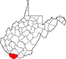 | |
| Towns | ||
| CDPs | ||
| Unincorporated communities |
| |
| Ghost town | ||
| Footnotes | ‡This populated place also has portions in an adjacent county or counties | |
This article is issued from
Wikipedia.
The text is licensed under Creative Commons - Attribution - Sharealike.
Additional terms may apply for the media files.