Alberta Highway 9
Route map:
| ||||
|---|---|---|---|---|
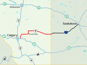 Alberta Highway 9 (highlighted in red) and Saskatchewan Highway 7 form a core route of the National Highway System between Calgary and Saskatoon | ||||
| Route information | ||||
| Length | 324.1 km[1] (201.4 mi) | |||
| Major junctions | ||||
| West end |
| |||
| East end |
| |||
| Location | ||||
| Specialized and rural municipalities | Rocky View County, Wheatland County, Kneehill County, Starland County, Special Area No. 2, Special Area No. 3 | |||
| Towns | Irricana, Drumheller, Hanna | |||
| Villages | Beiseker, Munson, Youngstown, Cereal | |||
| Highway system | ||||
|
Provincial highways in Alberta
| ||||

Alberta Provincial Highway No. 9, commonly referred to as Highway 9, is a highway in south-central Alberta, Canada, which together with Saskatchewan Highway 7 connects Calgary to Saskatoon, Saskatchewan via Drumheller. It is designated as a core route of the National Highway System, forming a portion of an interprovincial corridor.[2] Highway 9 spans approximately 324 km (201 mi) from the Trans-Canada Highway (Highway 1) east of Calgary to Alberta's border with Saskatchewan.[1][3][4]
Route description
Highway 9 begins at its interchange with Highway 1 approximately 10 km (6 mi) east of Chestermere and 20 km (12 mi) west of Strathmore, and approximately 6 km (4 mi) north of Langdon via Highway 797. For its first 45 km (28 mi), Highway 9 generally runs in a north/south direction to Beiseker. At Beiseker, Highway 9 runs in an east-west direction for 64 km (40 mi) to Drumheller. It then runs north/south for 22 km (14 mi) from Drumheller to its intersection with Highway 27 east of Morrin. The highway then runs east/west for the balance of route to the Saskatchewan border, providing connections to Hanna and Oyen as well as numerous smaller communities, and generally running parallel to Highway 12 to the north. The highway continues as Saskatchewan Highway 7 in a northeast direction toward Saskatoon.[2][4]
History
Over the past few years, the province of Alberta has executed a number of upgrades to the highway, widening shoulders and realigning the road (most recently just west of Drumheller, although the new alignment now bypasses the Horseshoe Canyon landmark as a result). As of 2007, however, the province has yet to twin any stretch of the busy highway, and there have been calls for interchanges to be built at its junctions with Highway 21 and the Trans-Canada due to the number of fatal automobile accidents that have happened at these locations.
A partial cloverleaf interchange was constructed in 2007 where Highway 9 crosses the Trans-Canada Highway. As well, the junction with Highway 21 was changed to a four-way stop in early 2011.
Major intersections
The following is a list of major intersections along Alberta Highway 9 from west to east.[1][4]
| Rural/specialized municipality | Location | km[3] | mi | Destinations | Notes | ||
|---|---|---|---|---|---|---|---|
| M.D. of Foothills No. 31 | | −22.6 | −14.0 | Hwy 797 southern terminus; unsigned | |||
| −19.7 | −12.2 | dead end | Hwy 797 northern terminus | ||||
| Gap in Hwy 797 / Range Road 273 (Bow River) | |||||||
| Rocky View County | | −16.2 | −10.1 | Township Road 220 | |||
| −8.1 | −5.0 | ||||||
| Langdon | −6.5 | −4.0 | Hwy 797 southern terminus | ||||
| | 0.0 | 0.0 | Interchange | ||||
| 13.0 | 8.1 | ||||||
| 19.4 | 12.1 | ||||||
| 32.7 | 20.3 | ||||||
| Irricana | 35.1 | 21.8 | UAR 144 west | ||||
| Beiseker | 43.2 | 26.8 | UAR 141 west | ||||
| 44.3 | 27.5 | Hwy 9 branches east; former Hwy 21A / Hwy 26 north | |||||
| Wheatland County / Kneehill County | | 63.8 | 39.6 | ||||
| 70.3 | 43.7 | Former Hwy 26 north | |||||
| 82.7 | 51.4 | ||||||
| Kneehill County | | 98.6 | 61.3 | ||||
| Town of Drumheller | 106.8 | 66.4 | 5 Street SE | Hwy 9 branches northwest; west end of Hwy 56 concurrency | |||
| 107.7 | 66.9 | 2 Street SW | Hwy 9 / Hwy 56 branches north | ||||
| 108.3 | 67.3 | Crosses the Red Deer River | |||||
| 108.8 | 67.6 | ||||||
| 109.1 | 67.8 | ||||||
| Starland County | Munson | 119.4 | 74.2 | Township Road 302 | |||
| | 129.0 | 80.2 | Hwy 9 branches east; east end of Hwy 56 concurrency | ||||
| 142.0 | 88.2 | ||||||
| 151.8 | 94.3 | ||||||
| 161.5 | 100.4 | UAR 122 north – Craigmyle | |||||
| Special Area No. 2 | | 172.9 | 107.4 | ||||
| 174.6 | 108.5 | ||||||
| Hanna | 183.1 | 113.8 | Palliser Trail (Range Road 144) | ||||
| | 189.8 | 117.9 | West end of Hwy 36 concurrency | ||||
| 192.4 | 119.6 | East end of Hwy 36 concurrency | |||||
| Special Area No. 3 | Youngstown | 237.0 | 147.3 | West end of Hwy 884 concurrency | |||
| | 244.0 | 151.6 | West end of Hwy 884 concurrency | ||||
| Cereal | 267.5 | 166.2 | |||||
| Oyen | 291.1 | 180.9 | |||||
| | 309.2 | 192.1 | West end Hwy 899 concurrency | ||||
| 310.9 | 193.2 | East end of Hwy 899 concurrency | |||||
| Sibbald | 314.2 | 195.2 | Range Road 20 | ||||
| | 324.1 | 201.4 | Alberta – Saskatchewan border Continues as | ||||
1.000 mi = 1.609 km; 1.000 km = 0.621 mi
| |||||||
Highway 797
| |
|---|---|
| Location | Langdon |
| Length | 9.4 km[5] (5.8 mi) |
Alberta Provincial Highway No. 797, commonly referred to as Highway 797, is a highway in the Calgary Region that functions as a southern extension of Highway 9. It presently is in two segments; the 6.5 km (4.0 mi) northern segment runs from Highway 560 (Glenmore Trail) in Langdon to the Trans-Canada Highway, while the 2.9 km (1.8 mi) southern section is unsigned and runs from Highway 552 to the south bank of the Bow River.[5] The northern segment used to extend from Langdon to the north bank of the Bow River, indicating that a bridge might be constructed to connect the two sections. The bridge was not constructed and the 9.7 km (6.0 mi) section was transferred to Rocky View County in the 2000s.[6]
References
- 1 2 3 "2015 Provincial Highway 1-216 Progress Chart" (PDF). Alberta Transportation. March 2015. Archived (PDF) from the original on April 10, 2016. Retrieved October 12, 2016.
- 1 2 "National Highway System". Transport Canada. 2009-12-13. Archived from the original on July 6, 2011. Retrieved 2011-03-14.
- 1 2 Google (November 22, 2017). "Highway 9 in Alberta" (Map). Google Maps. Google. Retrieved November 22, 2017.
- 1 2 3 Alberta Official Road Map (Map) (2010 ed.). Alberta Tourism, Parks and Recreation. § L–6, L-7, L–8.
- 1 2 "2017 Provincial Highway 500-986 Progress Chart" (PDF). Alberta Transportation. March 2017. Archived (PDF) from the original on September 26, 2017. Retrieved November 22, 2017.
- ↑ Alberta Transportation (August 2008). "Contract Maintenance of Provincial Highways" (PDF). County vs. Provincial Roads. Rocky View County. Retrieved November 22, 2017.