Alberta Highway 897

Highway 897 shield

Highway 897
Route information
Maintained by Alberta Transportation
Length 209 km[1] (130 mi)
South segment
Length 186 km (116 mi)
South end Hwy 14 north of Edgerton
Major
junctions
North end Hwy 55 south of Cold Lake
North segment
Length 23 km (14 mi)
South end Cold Lake city limits
Major
junctions
Hwy 55 west of Cold Lake
North end Township Road 652 west of Cold Lake Provincial Park
Location
Specialized
and rural
municipalities
Wainwright M.D. No. 61, Vermilion River County, St. Paul County No. 19, Bonnyville M.D. No. 87
Major cities Cold Lake
Villages Paradise Valley, Kitscoty, Marwayne
Highway system

Provincial highways in Alberta

Hwy 895Hwy 899

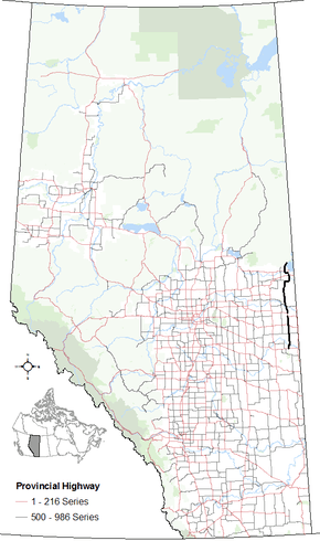
Alberta Provincial Highway No. 897[2] is a highway in the province of Alberta, Canada. It runs south-north in two sections, from Highway 14 north of Edgerton to Highway 55 south of Cold Lake, then from Kingsway at the west CFB Cold Lake limits to where Township Road 651 would be, west of Cold Lake Provincial Park. The south section runs between Highway 17 and Highway 41, the north section offers a route to resorts and vacation spots north of Cold Lake.

Major intersections

Starting from the south end of Highway 897:

Rural/specialized municipalityLocationkm[1]miDestinationsNotes
M.D. of Wainwright No. 6100.0 Hwy 14 Edmonton, Wainwright, The BattlefordsHwy 897 southern terminus
52°51′2″N 110°22′2″W / 52.85056°N 110.36722°W / 52.85056; -110.36722 (897 km 000)
County of Vermilion River2214Township Road 470 Paradise Valley53°1′49″N 110°19′20″W / 53.03028°N 110.32222°W / 53.03028; -110.32222 (897 km 022)
3622 Hwy 619 Viking53°9′40″N 110°19′21″W / 53.16111°N 110.32250°W / 53.16111; -110.32250 (897 km 036)
Kitscoty5635 Hwy 16 (TCH) Edmonton, Vermilion, Lloydminster53°19′59″N 110°19′19″W / 53.33306°N 110.32194°W / 53.33306; -110.32194 (897 km 056)
Marwayne7647 Hwy 45 east Prince AlbertHwy 897 branches north; Hwy 45 concurrency begins
53°31′2″N 110°19′31″W / 53.51722°N 110.32528°W / 53.51722; -110.32528 (897 km 076)
8352 Hwy 45 west Two HillsHwy 45 concurrency ends
53°35′4″N 110°19′32″W / 53.58444°N 110.32556°W / 53.58444; -110.32556 (897 km 083)
9257Crosses the North Saskatchewan River53°39′37″N 110°20′13″W / 53.66028°N 110.33694°W / 53.66028; -110.33694 (897 km 092)
9861 Hwy 641 east Tulliby Lake, Onion Lake53°42′49″N 110°21′15″W / 53.71361°N 110.35417°W / 53.71361; -110.35417 (897 km 098)
County of St. Paul No. 1910565 Hwy 646 west Heinsburg, Elk Point53°45′57″N 110°23′22″W / 53.76583°N 110.38944°W / 53.76583; -110.38944 (897 km 105)
Frog Lake11370Township Road 56253°49′52″N 110°24′6″W / 53.83111°N 110.40167°W / 53.83111; -110.40167 (897 km 113)
Unipouheos No. 12111773Road53°51′53″N 110°23′38″W / 53.86472°N 110.39389°W / 53.86472; -110.39389 (897 km 117)
Puskiakiwenin No. 12212880Road53°58′2″N 110°24′7″W / 53.96722°N 110.40194°W / 53.96722; -110.40194 (897 km 128)
M.D. of Bonnyville15898Township Road 605 Beaverdam54°13′1″N 110°21′20″W / 54.21694°N 110.35556°W / 54.21694; -110.35556 (897 km 158)
16099 Hwy 659 west BonnyvilleHwy 897 branches east
54°14′19″N 110°21′20″W / 54.23861°N 110.35556°W / 54.23861; -110.35556 (897 km 160)
167104Range Road 24 Cold Lake No. 14954°14′19″N 110°15′20″W / 54.23861°N 110.25556°W / 54.23861; -110.25556 (897 km 167)
171106Township Road 610 Elizabeth Metis SettlementHwy 897 turns north
54°14′27″N 110°11′5″W / 54.24083°N 110.18472°W / 54.24083; -110.18472 (897 km 171)
183114Crosses the Beaver River54°20′59″N 110°10′57″W / 54.34972°N 110.18250°W / 54.34972; -110.18250 (897 km 183)
186116 Hwy 55 to Hwy 28 Cold Lake, Bonnyville, Edmonton, Meadow LakeHwy 897 ends
54°22′10″N 110°11′35″W / 54.36944°N 110.19306°W / 54.36944; -110.19306 (897 km 186)
6 km (4 mi) gap in Hwy 897
City of Cold Lake192119 Hwy 28 / Hwy 55 Bonnyville, Edmonton, Meadow Lake
Centre Avenue, 50 Avenue
Former Hwy 897 alignment follows Centre Avenue
54°24′48″N 110°12′49″W / 54.41333°N 110.21361°W / 54.41333; -110.21361 (897 km 192)
194–
199
121–
124
Passes through CFB Cold Lake
200120Cold Lake city limitsHwy 897 resumes
54°25′26″N 110°19′39″W / 54.42389°N 110.32750°W / 54.42389; -110.32750 (897 km 200)
M.D. of Bonnyville204127 Hwy 55 Lac La Biche, Cold Lake54°27′24″N 110°20′1″W / 54.45667°N 110.33361°W / 54.45667; -110.33361 (897 km 204)
224139Range Road 423 – Marie Lake
Range Road 420 Cold Lake Provincial Park
Hwy 897 northern terminus; continues as Range Road 420
54°37′5″N 110°14′21″W / 54.61806°N 110.23917°W / 54.61806; -110.23917 (897 km 224)
1.000 mi = 1.609 km; 1.000 km = 0.621 mi
  •       Closed/former
  •       Concurrency terminus

References

  1. 1 2 Google (April 27, 2017). "Highway 897 in Alberta" (Map). Google Maps. Google. Retrieved April 27, 2017.
  2. Provincial Highways Designation Order, Alberta Transportation, p. 38


This article is issued from Wikipedia. The text is licensed under Creative Commons - Attribution - Sharealike. Additional terms may apply for the media files.