Alberta Highway 12
| ||||
|---|---|---|---|---|
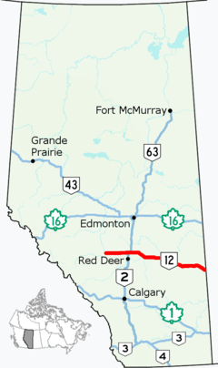 Highway 12 highlighted in red | ||||
| Route information | ||||
| Length | 363.8 km[1] (226.1 mi) | |||
| Major junctions | ||||
| West end |
| |||
| East end |
| |||
| Location | ||||
| Specialized and rural municipalities | Clearwater County, Lacombe County, Stettler No. 6 County, Paintearth No. 18 County, Special Area No. 4 | |||
| Major cities | Lacombe | |||
| Towns | Bentley, Stettler, Castor, Coronation | |||
| Villages | Alix, Botha, Halkirk, Veteran, Consort | |||
| Highway system | ||||
|
Provincial highways in Alberta
| ||||

Alberta Provincial Highway No. 12, commonly referred to as Highway 12, is an east-west highway through central Alberta. It runs from Highway 22, through Lacombe and Stettler, to the Alberta-Saskatchewan border. It generally runs parallel to Highway 13 to the north.[2] Highway 12 is about 364 kilometres (226 mi) long.[1]
Route description
Highway 12 begins at Highway 22, approximately 10 km (6 mi) north of Rocky Mountain House, and travels due east to Bentley where it intersects Highway 20. It continues along the south of Gull Lake and the summer village of Gull Lake, before intersecting Highway 2 (Queen Elizabeth II Highway). East of Highway 2, it passes through the city of Lacombe as 50 Avenue before continues east past the village of Clive. At the intersection of Highway 50 near Tees, Highway 12 turns southeast, passing through the village of Alix and shares a short concurrency with Highway 21, before turning east at Highway 11 near Nevis. It passes through Erskine before it enters Stettler and intersects Highway 56. East of Stettler, it passes Botha, Gadsby, and Halkirk before turning southeast. It passes through Castor, intersects Highway 36 (Veterans Memorial Highway), and passes through Fleet, Coronation, Throne, and Veteran. It shares a 18 km (11 mi) concurrency with Highway 41 (Buffalo Trail) between Consort and Monitor before continuing past Kirriemuir and Altario, finally reaching the Saskatchewan border near Compeer where it continues as Saskatchewan Highway 51.[3]
History
Highway 12 originally travelled 90 km (56 mi) north from Bentley, through Rimbey and Breton, terminating at Highway 39 at Alsike.[4] In the mid-1980s, the section north of Bentley was renumbered to Highway 20 while Highway 51, which at the time travelled west from Bentley and terminated at Highway 761 north of Leslieville, became part of Highway 12.[5] In the 1990s, Highway 12 was extended west to Highway 22.[6]
Major intersections
From west to east:[7]
| Rural/specialized municipality | Location | km[1] | mi | Destinations | Notes |
|---|---|---|---|---|---|
| Clearwater County | | 0.0 | 0.0 | ||
| 22.7 | 14.1 | ||||
| Lacombe County | | 39.0 | 24.2 | ||
| Bentley | 58.6 | 36.4 | |||
| 61.2 | 38.0 | ||||
| Gull Lake | 68.6 | 42.6 | |||
| | 70.4 | 43.7 | |||
| City of Lacombe | 79.2 | 49.2 | Interchange; exit 422 on Hwy 2 | ||
| 83.0 | 51.6 | ||||
| Lacombe County | | 96.4 | 59.9 | ||
| 102.1 | 63.4 | UAR 111 north – Clive | |||
| 110.4 | 68.6 | UAR 88 north – Tees | |||
| 111.0 | 69.0 | ||||
| 111.4 | 69.2 | ||||
| Alix | 124.2 | 77.2 | |||
| | 129.9 | 80.7 | West end of Hwy 21 concurrency; unsigned Hwy 921 south | ||
| ↑ / ↓ | | 131.6 | 81.8 | East end of Hwy 21 concurrency | |
| County of Stettler No. 6 | Nevis | 137.3 | 85.3 | ||
| | 139.4 | 86.6 | |||
| Erskine | 147.6 | 91.7 | |||
| Town of Stettler | 159.3 | 99.0 | |||
| 160.4 | 99.7 | 47 Avenue / 50 Street | Hwy 12 branches south, then turns east | ||
| County of Stettler No. 6 | | 169.9 | 105.6 | West end of Hwy 850 concurrency | |
| Botha | 173.3 | 107.7 | East end of Hwy 850 concurrency | ||
| Gadsby | 185.4 | 115.2 | |||
| County of Paintearth No. 18 | | 198.4 | 123.3 | West end of Hwy 855 concurrency | |
| Halkirk | 200.3 | 124.5 | East end of Hwy 855 concurrency | ||
| Castor | 218.5 | 135.8 | |||
| | 222.9 | 138.5 | |||
| Coronation | 253.1 | 157.3 | West end of Hwy 872 concurrency | ||
| 254.8 | 158.3 | East end of Hwy 872 concurrency | |||
| Special Area No. 4 | Veteran | 278.4 | 173.0 | West end of Hwy 884 concurrency | |
| | 280.0 | 174.0 | East end of Hwy 884 concurrency | ||
| Consort | 303.2 | 188.4 | West end of Hwy 41 concurrency | ||
| Monitor | 320.5 | 199.1 | East end of Hwy 41 concurrency | ||
| | 338.1 | 210.1 | Range Road 31 – Kirriemuir | ||
| Altario | 349.5 | 217.2 | |||
| Compeer | 363.8 | 226.1 | Continues into Saskatchewan | ||
1.000 mi = 1.609 km; 1.000 km = 0.621 mi
| |||||
Route map:
Highway 12A
| |
|---|---|
| Location | Bentley – Gull Lake |
| Length | 9.1 km (5.7 mi) |
| Existed | 2017–present |
Alberta Provincial Highway No. 12A is the designation of a 9 km (6 mi) alternate route off Highway 12 serving the south shore of Gull Lake.[2]
In 2012, Alberta Transportation commenced construction of a realignment of Highway 12 between Bentley and Gull Lake, approximately one-half kilometre (1⁄4 mi) south of the original alignment, bypassing the two communities as well as Aspen Beach Provincial Park.[8] In 2017, Highway 12 was designated along the new roadway while the former alignment became Highway 12A.
References
- 1 2 3 Google (November 20, 2017). "Highway 12 in central Alberta" (Map). Google Maps. Google. Retrieved November 20, 2017.
- 1 2 "2017 Provincial Highway 1-216 Progress Chart" (PDF). Alberta Transportation. March 2017. Retrieved September 18, 2018.
- ↑ Alberta Culture and Tourism. Alberta Official Road Map (Map) (2017 ed.). City of Edmonton. §§ K–5, K–6, K–7, and K–8.
- ↑ Travel Alberta. Alberta Official Road Map (Map) (1984 ed.). The Province of Alberta. §§ K–5, and J–5.
- ↑ Travel Alberta. Alberta Official Road Map (Map) (1988 ed.). The Province of Alberta. § K-5.
- ↑ Alberta Tourism Partnership. Alberta Official Road Map (Map) (1997 ed.). The Province of Alberta. § K-5.
- ↑ Alberta Road Atlas (2005 ed.). Oshawa, ON: MapArt Publishing Corp. pp. 63, 64, 65, 66, 72, and 73.
- ↑ "Highway 12, near the Town of Bentley". Lacombe County. Alberta Transportation. May 2016. Retrieved September 18, 2018.