Alberta Highway 5
| ||||
|---|---|---|---|---|
 Highway 5 highlighted in red | ||||
| Route information | ||||
| Length | 129.1 km[1] (80.2 mi) | |||
| Major junctions | ||||
| South end | Mt. View Rd in Waterton Park | |||
| ||||
| North end |
| |||
| Location | ||||
| Specialized and rural municipalities | I.D. No. 4, Cardston County, Warner No. 5 County, Lethbridge County | |||
| Major cities | Lethbridge | |||
| Towns | Magrath, Cardston | |||
| Highway system | ||||
|
Provincial highways in Alberta
| ||||

.svg.png)
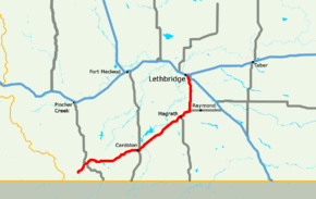
Alberta Provincial Highway No. 5, commonly referred to as Highway 5, is a 129-kilometre (80 mi) highway that connects Lethbridge to Waterton Lakes National Park in southern Alberta, Canada. It begins as an east–west highway in Waterton and transitions to a north–south route before ending at Crowsnest Trail (Highway 3) in Lethbridge.[2][3]
Highway 5 is part of the Cowboy Trail between Highway 6 in Waterton Lakes National Park and Cardston.[4]
Route description
Highway 5 begins in the Hamlet of Waterton Park within Waterton Lakes National Park. After leaving the park, the highway generally travels east, passing by the hamlets of Mountain View and Leavitt, to the Town of Cardston.[1] After Cardston, the highway generally travels northeast, passing by the Hamlet of Spring Coulee, the Town of Magrath, and the Hamlet of Welling Station. Shortly after Welling Station, the highway travels north, passing the Hamlet of Welling, before ending at Highway 3 in Lethbridge.[2][3]
Highway 5 is known as Mayor Magrath Drive within Lethbridge city limits.
Major intersections
The following is a list of major intersections along Alberta Highway 5 from southwest to northeast.[2][3]
| Rural/specialized municipality | Location | km[1] | mi | Destinations | Notes | ||
|---|---|---|---|---|---|---|---|
| I.D. No. 4 (Waterton Lakes National Park) | Waterton Park | 0.0 | 0.0 | ||||
| | 8.6 | 5.3 | Hwy 5 branches south; west end of Hwy 6 concurrency | ||||
| West end of Cowboy Trail | |||||||
| 9.5 | 5.9 | Hwy 5 turns east; east end of Hwy 6 concurrency | |||||
| Cardston County | | 26.4 | 16.4 | ||||
| Mountain View | 28.6 | 17.8 | |||||
| | 33.0 | 20.5 | |||||
| Cardston | 53.3 | 33.1 | Cardston Truck Bypass (unsigned Hwy 501) | Hwy 5 branches north; west end of Hwy 2 concurrency | |||
| East end of Cowboy Trail | |||||||
| Blood I.R. No. 148 | 54.0 | 33.6 | Hwy 5 branches northeast; east end of Hwy 2 concurrency | ||||
| ↑ / ↓ | | 57.1 | 35.5 | Crosses the St. Mary River | |||
| Cardston County | | 58.1 | 36.1 | ||||
| 74.3 | 46.2 | ||||||
| Spring Coulee | 76.8 | 47.7 | |||||
| Magrath | 94.8 | 58.9 | |||||
| Welling | 102.6 | 63.8 | Hwy 5 turns north | ||||
| Lethbridge County | | 118.9 | 73.9 | ||||
| 121.8 | 75.7 | ||||||
| City of Lethbridge | 125.8 | 78.2 | Former alignment of Hwy 4 | ||||
| 129.1 | 80.2 | Interchange | |||||
| Mayor Magrath Drive continues north | |||||||
1.000 mi = 1.609 km; 1.000 km = 0.621 mi
| |||||||
See also
External links
Route map:
References
- 1 2 3 Google (November 22, 2017). "Highway 5 in Alberta" (Map). Google Maps. Google. Retrieved November 22, 2017.
- 1 2 3 "2015 Provincial Highway 1-216 Progress Chart" (PDF). Alberta Transportation. March 2015. Archived (PDF) from the original on April 10, 2016. Retrieved November 9, 2016.
- 1 2 3 Alberta Official Road Map (Map) (2010 ed.). Alberta Tourism, Parks and Recreation. § N-6, O-5, O-6.
- ↑ "Cowboy Trail Map". The Cowboy Trail. The Cowboy Trail Tourism Association. Retrieved July 30, 2018.