Alberta Highway 566
| ||||
|---|---|---|---|---|
| 176 Avenue N, Township Road 262 | ||||
 | ||||
| Route information | ||||
| Maintained by Alberta Transportation | ||||
| Length | 34.33 km[1] (21.33 mi) | |||
| Major junctions | ||||
| West end |
| |||
|
| ||||
| East end |
| |||
| Location | ||||
| Specialized and rural municipalities | Rocky View County | |||
| Major cities | Calgary | |||
| Highway system | ||||
|
Provincial highways in Alberta
| ||||

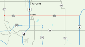
Alberta Provincial Highway No. 566 in the Canadian province of Alberta lies approximately halfway between Calgary and Airdrie, running west to east from Highway 772 (Symons Valley Road) to Highway 9 near the hamlets of Kathyrn and Keoma.[2]
North of Calgary, from between Range Road 15 & 20 (Panorama Road (24 Street NW) & Mountain View Road) to Range Road 10A (20 Street NE), it is given the designation 176 Avenue N, however it does not enter city limits, with the boundary on the south side of the right of way.
Alberta Transportation has plans to upgrade Highway 566 to a divided expressway. [3]
Major intersections
Starting from the west end of Highway 566. The entire route is in Rocky View County.
| Location | km[2] | mi | Destinations | Notes | |
|---|---|---|---|---|---|
| | 0.0 | 0.0 | Hwy 566 western terminus | ||
| 6.9 | 4.3 | Range Road 13 / Centre Street (Calgary) | Former Hwy 782 south | ||
| 10.1 | 6.3 | Range Road 15 / 15 Street NE (Calgary) – Airdrie (8 Street) | |||
| Balzac | 11.7 | 7.3 | Interchange (Hwy 2 Exit 275) Fifth Meridian, 114° Longitude | ||
| 12.5 | 7.8 | CrossIron Mills Boulevard – CrossIron Mills Shopping Centre | |||
| 13.1 | 8.1 | Range Road 293 / Dwight McLellan Trail – Calgary (Métis Trail) | |||
| | 27.7 | 17.2 | |||
| Kathyrn | 32.6 | 20.3 | Range Road 273 | ||
| | 34.2 | 21.3 | Hwy 566 eastern terminus | ||
| Keoma | 36.2 | 22.5 | 1st Avenue / Township Road 262 | Township Road 262 continues east | |
1.000 mi = 1.609 km; 1.000 km = 0.621 mi
| |||||
See also
Route map:
References
- ↑ "Provincial Highways 500 - 986 Progress Chart" (PDF). Alberta Transportation. March 2015. Retrieved December 26, 2016.
- 1 2 Google (November 4, 2016). "Highway 566 near Calgary, Alberta" (Map). Google Maps. Google. Retrieved November 4, 2016.
- ↑ "Highway 566 Access Management and Functional Planning Study" (PDF). Alberta Transportation. March 2010. Archived (PDF) from the original on December 26, 2016. Retrieved December 26, 2016.
This article is issued from
Wikipedia.
The text is licensed under Creative Commons - Attribution - Sharealike.
Additional terms may apply for the media files.