Alberta Highway 43
Route map:
| ||||
|---|---|---|---|---|
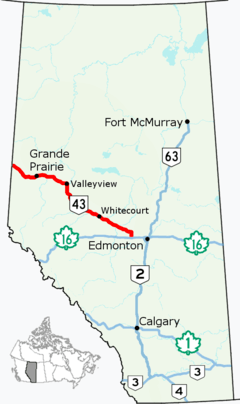 Highway 43 highlighted in red | ||||
| Route information | ||||
| Length | 496.6 km[1] (308.6 mi) | |||
| Major junctions | ||||
| West end |
| |||
| ||||
| East end |
| |||
| Location | ||||
| Specialized and rural municipalities | County of Grande Prairie No. 1, Greenview No. 16 M.D., Woodlands County, Lac Ste. Anne County, Parkland County | |||
| Major cities | Grande Prairie | |||
| Towns | Beaverlodge, Wembley, Valleyview, Fox Creek, Whitecourt, Mayerthorpe | |||
| Villages | Hythe | |||
| Highway system | ||||
|
Provincial highways in Alberta
| ||||

Alberta Provincial Highway No. 43, commonly referred to as Highway 43, is a major highway in northern and central Alberta, Canada that connects Edmonton to the British Columbia border via the Peace Country, forming the northernmost portion of the CANAMEX Corridor in Alberta. It stretches approximately 499 km (310 mi) from Highway 16 (Yellowhead Highway) near Carvel west of Edmonton to the British Columbia border west of Demmitt.[2][3] It is designated as a core route in Canada's National Highway System, comprising a portion of a key international corridor that stretches from Alaska into Mexico.
Highway 43 was originally numbered Highway 17, a short gravel road that ran only from Highway 16 to Onoway. It was later extended to Whitecourt and renumbered as Highway 43 in the 1940s, and an extension to Valleyview had been completed by the mid-1950s. In 1991 the highway was extended to included a portion of the existing Highway 34 from Valleyview to Donnelly, but was revised in 1998 to turn west through Grande Prairie, forming a contiguous route from Carvel to the border. Due to increasing traffic levels and the province's greater plan to upgrade their portion of the CANAMEX Corridor, work began in the 2000s to twin the entire length of the highway. The Edmonton–Grande Prairie section was completed in summer 2014,[4] and construction began in 2016 on an expressway bypass to the northwest of Grande Prairie. Planning is underway for the remaining section between the BC border and Beaverlodge.
Route description
Highway 43 begins west of Demmitt at the British Columbia border and runs through Grande Prairie, Valleyview, and Whitecourt to Highway 16 near Carvel west of Edmonton.[1]
History
Construction and paving
The history of Highway 43 dates back to the late 1920s or early 1930s. It was originally numbered Highway 17 and, by 1932, it spanned approximately 17 km from Highway 16 to Onoway. By 1938, Highway 17 (now 43) had been extended to Sangudo and it had reached Whitecourt via a jagged alignment with numerous 90° jogs by 1940. Sometime between 1942 and 1946, the highway was renumbered to Highway 43. The former number was transferred to Highway 17 that straddles the Alberta/Saskatchewan provincial boundary north and south of Lloydminster.[5][6]
By 1952, extension of Highway 43 from Whitecourt to Valleyview was well underway. The segment of the highway from Valleyview to Little Smoky was complete, while the segment from Whitecourt to Two Creeks was under construction. The next segment of the highway, from Little Smoky to west of Giroux Lake, opened a year later. In 1954, the connecting segment of Highway 43 between west of Giroux Lake and Two Creeks was under construction. Meanwhile, paving of the highway between Highway 16 and Gunn was complete.
The final segment of Highway 43 between Whitecourt and Valleyview was officially completed in 1955 and a ribbon-cutting ceremony was held in the Iosegun River valley, approximately 20 km southeast of Fox Creek. The completion of the highway provided the south Peace Region of northwest Alberta, particularly Grande Prairie and Valleyview, with a more direct and significantly shorter route to Edmonton. It also slightly shortened the driving distance from Peace River to Edmonton once the Highway 34 realignment north of Valleyview was completed by 1959. An aggressive paving program began shortly after the highway was completed. Paving began northwest of Whitecourt and south of Valleyview. By 1960, the entire length of the highway was paved, which included a significant realignment between Whitecourt and Cottonwood Corner south of Blue Ridge and other minor realignments between Cottonwood Corner and Gunn to smooth out the highway's numerous jogs.
Extension by renumbering
In 1990/1991, Highway 43 was extended by the Province through a highway renumbering. In particular, the stretch of highway between Valleyview and Donnelly (Highways 34 and 2) was renumbered to Highway 43. However, this extension proved to last only until 1998 when the Province completed a second set of highway renumberings in northwest Alberta.[7]
On March 1, 1998, the portion of Highway 43 north of Valleyview was renumbered to Highway 49 to allow for the renumbering of Highway 34 (from Valleyview to north of Grande Prairie) and Highway 2 (from north of Grande Prairie to the British Columbia border via Grande Prairie, Beaverlodge and Hythe) was renumbered as Highway 43.[7] The renumbering had two advantages – it established Highway 43 as a continuous highway number from Highway 16 through the Peace Country to the British Columbia border, simplifying travel. It also created fewer highway number changes along the CANAMEX Corridor, the Alberta portion of which stretches from Coutts at the United States border to the BC border west of Grande Prairie.[7]
Twinning

The initial twinning of Highway 43 began in the early 1970s with the first segment, from Highway 16 to north of Highway 633 (then numbered Highway 33), open by 1974. Eight years later, the second segment was twinned from north of Highway 633 to west of Gunn.
Twinning of Highway 43 then ceased for 15 years until a segment within Whitecourt from Govenlock Road/Mill Road, just east of the McLeod River, to east of 33 Street in Whitecourt's southeast end was opened by 1997. Shortly after this segment was twinned, the Province announced an aggressive twinning program for the highway from Gunn to the BC border as part of Alberta's North-South Trade (CANAMEX) Corridor initiative. By 1999, the twinning program saw its first two segments open – from Grande Prairie westward towards British Columbia (halfway to Wembley) and from Whitecourt eastward towards Edmonton (halfway to Highway 658).
Two years later, the twinned portions of Highway 43 west of Grande Prairie and east of Whitecourt had been extended to Highway 724 serving Wembley and Highway 658 serving Blue Ridge respectively. Also in 2001, twinning in three other locations was complete – from east of Highway 2 to west of Highway 733 (east of Grande Prairie), from the eastern boundary of the Sturgeon Lake Cree Nation through Valleyview to south of Highway 665, and from northwest of Fox Creek to southeast of Fox Creek near the Highway 947 intersection.
In 2002, the two largest newly twinned segments of Highway 43 had opened to traffic. The largest segment stretched from Whitecourt to west of Two Creeks. The other segment stretched from west of Highway 733 to Crooked Creek, which included a realignment to bypass Bezanson. The interchange with Highway 2 north of Grande Prairie also opened to traffic on October 3, 2002.[8] By 2003, the first newly twinned segment in over 20 years at Highway 43's southeastern end was open to traffic – starting from west of Gunn and ending east of Highway 765 near Glenevis. Also, the brief 2 km segment from Highway 2 (north of Grande Prairie) to east of Highway 2 opened upon completion of an interchange at Highway 2 and a grade separation over a CN rail line. By 2004, three additional segments of Highway 43 had been twinned. The first was from northwest of Fox Creek to near Giroux Lake. The second was filling in the gap between Fox Creek and Whitecourt from west of Highway 947 to west of Two Creeks. The third was from east of Highway 658 to east of Green Court/Highway 18.[9]
-and-Highway-43.jpg)
In 2005, three segments of twinned Highway 43 opened to traffic including 15.4 km (9.6 mi) from west of Fox Creek to west of Iosegun Lake, 19.1 km (11.9 mi) from west of Sangudo to west of Cherhill, and 14.1 km (8.8 mi) from west of Cherhill to west of Gunn.[10] The twinning of two additional segments of Highway 43 was completed in 2007, including 35 km (22 mi) from Asplund Creek (south of Highway 665) to west of Iosegun Lake (south of Little Smoky), and 18.5 km (11.5 mi) from east of Green Court to west of Sangudo.[11] With these segments completed, over 300 km (190 mi) of Highway 43 was continuously twinned from Highway 16 to west of Valleyview.
Also in 2007, the Government of Alberta announced that twinning of Highway 43 would go through the Sturgeon Lake Cree Nation[12] after previously deciding in 2006 to bypass it by routing the highway to the north side of Sturgeon Lake.[13] Subsequently, construction of the remaining 36 km (22 mi) between Crooked Creek and Valleyview, including 17 km (11 mi) through the Sturgeon Lake Cree Nation, began in the fall of 2010 and was completed on Sept. 12, 2014.[14] In 2010, 13 km (8.1 mi) from Highway 723 east of Beaverlodge to Highway 724 at Wembley was twinned.[15]
Future
| |
|---|---|
| Location | County of Grande Prairie No. 1 |
| Length | 4.0 km (2.5 mi) |
Highway 43X is the temporary designation of two future realignments of Highway 43 in northwest Alberta – one is a partially constructed northwest bypass around Grande Prairie, and the other will act as a south bypass around Whitecourt once constructed in the future.[2]
Grande Prairie bypass
The first segment of the Highway 43X bypass around Grande Prairie opened to traffic on July 30, 2010 to a twinned standard.[16] It is 4 km (2.5 mi) in length, extending westward from the Highway 43/2 interchange, 2.5 km (2 mi) north of Grande Prairie city limits, to 116 Street/Range Road 63 serving Grande Prairie to the south and the County of Grande Prairie No. 1 to the north.[16] The next segment of the bypass, approximately 10 km (6.2 mi) in length, is currently in the detailed design stage.[16] It will connect back to Highway 43 west of the Grande Prairie Airport.[16]
Highway 43X is Grande Prairie's second northwest bypass. The first northwest bypass, built in the late 1960s, follows the current designation of Highway 43 from the intersection of 100 Street and 116 Avenue in north Grande Prairie, crossing Bear Creek, to the intersection of 108 Street and 100 Avenue in west Grande Prairie. With the introduction of development on the north and west sides of the current bypass over the past two decades, the route is no longer functioning as a true bypass due to a high volume of local traffic and the erection of numerous traffic lights along the corridor.
Whitecourt bypass
A study for the future alignment of a south bypass around Whitecourt was completed in the 1980s, with a future alignment being registered in 1984.[17] The registered alignment begins in west Whitecourt, just north of a Canadian National (CN) rail line, and ends southeast of Whitecourt, just west of Highway 43's current at-grade intersection with East Mountain Road (Range Road 115B)/Deer Foot Road (Township Road 592B).[18] The bypass will cross over the CN rail line, Highway 32, the McLeod River, Govenlock Road/West Mountain Road (Range Road 122) and Beaver Creek.[18] Three interchange opportunities have been identified – one in the vicinity of the current Highway 43/32 interchange in west Whitecourt, one at Govenlock Road/West Mountain Road, and one at the east end of the bypass southeast of Whitecourt.[18] The design of the future interchange in west Whitecourt is anticipated to be complicated by the convergence of two existing highways, the adjacency of the CN rail line, the short distance between Highway 32 and the McLeod River to the south, existing highway commercial and industrial development along Highway 43 and Highway 32 respectively, and the close proximity of another interchange opportunity 1.2 km (0.75 mi) to the southeast at Govenlock Road/West Mountain Road, just east of the McLeod River.
A functional planning study was initiated in 2008 for the Highway 43/43X interchange southeast of Whitecourt.[17] The study considers three options, all of which incorporate a direct connection to East Mountain Road.[17] Construction of the interchange is not anticipated to occur for 5–10 years.[17] A functional plan for the remainder of the bypass has not yet been undertaken, and is anticipated to be planned under a separate project.[17]
Major intersections
| Rural/specialized municipality | Location | km[1] | mi | Destinations | Notes |
|---|---|---|---|---|---|
| County of Grande Prairie No. 1 | | 0.0 | 0.0 | British Columbia border Continues as | |
| 20.2 | 12.6 | ||||
| Hythe | 32.4 | 20.1 | |||
| 34.7 | 21.6 | ||||
| | 42.3 | 26.3 | |||
| Beaverlodge | 48.0 | 29.8 | |||
| | 52.8 | 32.8 | |||
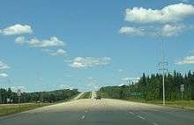
| 53.9 | 33.5 | Divided highway begins | |||
| 56.5 | 35.1 | ||||
| 64.8 | 40.3 | Range Road 85 | Former Hwy 724 south[19][20] | ||
| Wembley | 68.1 | 42.3 | |||
| | 71.4 | 44.4 | PAR 117 north – Saskatoon Island Provincial Park | ||
| City of Grande Prairie | 81.1 | 50.4 | Interchange under construction[21] | ||
| 86.0 | 53.4 | ||||
| 87.6 | 54.4 | 116 Street | Connects to present terminus of Hwy 43X | ||
| 89.3 | 55.5 | 100 Avenue – City Centre | Hwy 43 branches north | ||
| 90.8 | 56.4 | 108 Street / 106 Street | Hwy 43 turns east (becomes 116 Avenue) | ||
| 92.3 | 57.4 | 116 Avenue 100 Street – City Centre | Hwy 43 branches north | ||
| 93.9 | 58.3 | ||||
| County of Grande Prairie No. 1 | Clairmont | 97.1 | 60.3 | Interchange; Hwy 43 branches east | |
| Bezanson | 123.2 | 76.6 | |||
| ↑ / ↓ | | 131.4 | 81.6 | Crosses the Smoky River | |
| M.D. of Greenview No. 16 | | 138.1 | 85.8 | Forestry Trunk Road | Former Hwy 734 |
| DeBolt | 147.8 | 91.8 | |||
| Sturgeon Heights | 174.2 | 108.2 | PAR 135 north – Young's Point Provincial Park | ||
| Sturgeon Lake No. 154 | Calais | 182.5 | 113.4 | PAR 113 north – Williamson Provincial Park | |
| M.D. of Greenview No. 16 | Valleyview | 201.0 | 124.9 | Hwy 43 turns south | |
| | 208.3 | 129.4 | |||
| 239.8 | 149.0 | Crosses the Little Smoky River | |||
| Little Smoky | 240.5 | 149.4 | Little Smoky Road | Former Hwy 745 | |
| Fox Creek | 287.0 | 178.3 | Smoke Lake Road / Kaybob Drive | ||
| | 302.1 | 187.7 | |||
| Woodlands County | | 360.2 | 223.8 | West end of Hwy 32 concurrency | |
| Whitecourt | 366.2 | 227.5 | Crosses the Athabasca River | ||
| 368.1 | 228.7 | East end of Hwy 32 concurrency | |||
| 368.4 | 228.9 | Crosses the McLeod River | |||
| 369.2 | 229.4 | 51 Street | |||
| 371.0 | 230.5 | Dahl Drive / Pine Road | |||
| | 390.7 | 242.8 | |||
| 393.2 | 244.3 | ||||
| Lac Ste. Anne County | Green Court | 403.5 | 250.7 | ||
| Mayerthorpe | 413.1 | 256.7 | |||
| Rochfort Bridge | 420.5 | 261.3 | UAR 68 north | ||
| | 428.7 | 266.4 | West end of Hwy 757 concurrency | ||
| 430.4 | 267.4 | Crosses the Pembina River | |||
| Sangudo | 431.1 | 267.9 | East end of Hwy 757 concurrency | ||
| Cherhill | 448.0 | 278.4 | |||
| | 453.5 | 281.8 | |||
| Gunn | 472.0 | 293.3 | Range Road 32 (St. Anne Trail) – Alberta Beach | ||
| 472.9 | 293.8 | ||||
| | 479.0 | 297.6 | |||
| Onoway | 482.3 | 299.7 | UAR 84 east (Lac St. Anne Trail) | ||
| | 486.9 | 302.5 | Former Hwy 33 west | ||
| Parkland County | | 496.6 | 308.6 | Interchange; Exit 340 on Hwy 16; CANAMEX Corridor follows Hwy 16 east | |
| Southbound exit only; full access via Hwy 16 west | |||||
1.000 mi = 1.609 km; 1.000 km = 0.621 mi
| |||||
See also
References
- 1 2 3 Google (December 8, 2017). "Highway 43 in northern Alberta" (Map). Google Maps. Google. Retrieved December 8, 2017.
- 1 2 "2016 Provincial Highway 1-216 Progress Chart" (PDF). Alberta Transportation. March 2016. Archived (PDF) from the original on November 12, 2016. Retrieved November 12, 2016.
- ↑ Alberta Official Road Map (Map) (2011 ed.). Alberta Tourism, Parks and Recreation. § G–1, G–2, G–3, H–3, H–4, I–4, I–5.
- ↑ "Highway 43 twinning complete". Government of Alberta. 2014-09-12. Retrieved 2015-07-07.
- ↑ Province of Alberta Official Road Map (Map) (1942 ed.). Department of Public Works.
- ↑ Province of Alberta Official Road Map (Map) (1946 ed.). Department of Public Works.
- 1 2 3 Government of Alberta (1998-02-24). "Primary Highway renumbering to take place in the Peace Region". Retrieved 2010-08-01.
- ↑ "New Grande Prairie interchange now open to traffic" (PDF). Government of Alberta. October 3, 2002. Retrieved October 17, 2013.
- ↑ "More lanes open to traffic on Highway 43". Government of Alberta. 2003-10-10. Retrieved 2011-10-29.
- ↑ "Road construction further divides Highway 43". Government of Alberta. 2005-06-27. Retrieved 2011-10-29.
- ↑ "Latest twinned section on Highway 43 improves safety for motorists". Government of Alberta. 2007-09-20. Retrieved 2011-10-29.
- ↑ "Highway 43 twinning to go through Sturgeon Lake Cree Nation". Government of Alberta. 2007-10-05. Retrieved 2011-10-29.
- ↑ Kevin Crush (2006-09-22). "Hwy. 43 to skirt reserve". Daily Herald–Tribune. Sun Media Corporation.
- ↑ "Writing a new chapter in Alberta's Transportation history". Government of Alberta. 2010-10-07. Retrieved 2011-10-29.
- ↑ "Highway 43 gets new lanes between Wembley and Beaverlodge". Government of Alberta. 2007-09-20. Retrieved 2010-11-04.
- 1 2 3 4 Government of Alberta (July 29, 2010). "New Grande Prairie bypass opens to traffic for long weekend". Archived from the original on July 16, 2011. Retrieved August 1, 2010.
- 1 2 3 4 5 Alberta Transportation. "Highway 43/43X South Interchange Functional Planning Study". Retrieved 2010-08-01.
- 1 2 3 Town of Whitecourt (November 2008). "Imagine Whitecourt – Whitecourt's Municipal Development Plan, Bylaw 1428 (see Map 6)" (PDF). Retrieved 2010-08-01.
- ↑ "2010 Provincial Highways 500 – 986 Progress Chart" (PDF). Alberta Transportation. March 2010. Retrieved 2011-05-30.
- ↑ "2011 Provincial Highways 500 – 986 Series Progress Chart" (PDF). Alberta Transportation. March 2011. Retrieved 2011-05-30.
- ↑ "West Provincial Highway Projects". Grande Prairie Bypass. Government of Alberta. April 27, 2016. Retrieved July 21, 2017.