Alberta Highway 49
| ||||
|---|---|---|---|---|
|
Northern Woods and Water Route Spirit River Highway | ||||
 | ||||
| Route information | ||||
| Length | 265.9 km[1] (165.2 mi) | |||
| Major junctions | ||||
| West end |
| |||
| South end |
| |||
| Location | ||||
| Specialized and rural municipalities | Saddle Hills County, Spirit River No. 133 M.D., Birch Hills County, Smoky River No. 130 M.D., Greenview No. 16 M.D. | |||
| Towns | Spirit River, Falher, Valleyview | |||
| Villages | Rycroft, Donnelly | |||
| Highway system | ||||
|
Provincial highways in Alberta
| ||||

.svg.png)
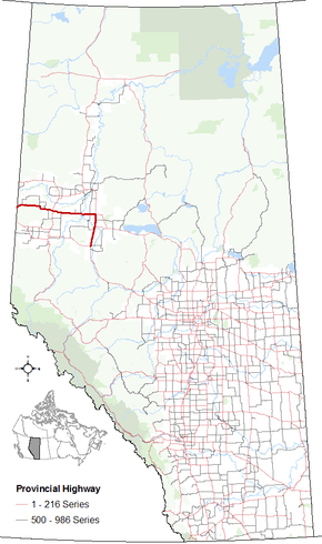
Alberta Provincial Highway No. 49, commonly referred to as Highway 49, is a highway in northwestern Alberta, Canada. It runs east-west from the British Columbia border to Donnelly, and then north-south to Valleyview.[2] Highway 49 has a total length of 266 kilometres (165 mi).[1]
The portion of Highway 49 from Donnelly to the British Columbia is also known as the Spirit River Highway. It also comprises the westernmost segment of Alberta's portion of the Northern Woods and Water Route. After Donnelly, the Northern Woods and Water Route continues eastward along Highway 2 and then Highway 55.[3][4] Its southernmost section, between Highway 2 and Highway 43, is designated as a core route of Canada's National Highway System.
Route description
Highway 49 begins at the Alberta/British Columbia border (where it continues as British Columbia Highway 49 to the City of Dawson Creek) 8 km (5.0 mi) west of the locality of Bay Tree and is part of the Northern Woods and Water Route. The highway passes through Bay Tree, the locality of Gordondale, the Town of Spirit River, before intersecting Highway 2 in the Village of Rycroft. The highway continues east, passing by the hamlets of Wanham, Eaglesham, Tangent, and Watino before crossing the Smoky River. The highway then passes by the Village of Girouxville and the Town of Falher before again intersecting Highway 2, approximately 2 km (1 mi) west of the Village of Donnelly.[1]
At the Highway 2 intersection, known locally as the 'Donnelly Corner', Highway 49 turns south and becomes part of a core route of Canada's National Highway System while the Northern Woods and Water Route continues eastward along Highway 2. The highway passes Guy and New Fish Creek before entering Valleyview and terminating at an intersection with Highway 43.[3]
History
The southern and easternmost sections of Highway 49 have seen a variety of highway designations.
Prior to 1990, Highway 49 continued east past Donnelly and through the Town of McLennan before terminating at Highway 2 in Triangle, 14 km (8.7 mi) west of the Town of High Prairie, along present-day Highway 2. At the same time, its present-day alignment between Donnelly and Valleyview was designated as Highway 34.[5][6]
In 1990/1991, Highway 34 between Valleyview and Donnelly was renumbered to Highway 43 and Highway 49 between Triangle and Donnelly was renumbered to Highway 2, resulting in Highway 49 terminating at the Donnelly Corner.[6]
Finally, on March 1, 1998, Highway 43 between Valleyview and Donnelly was renumbered to Highway 49 to allow for Highway 43 to travel west from Valleyview to Grande Prairie and the British Columbia border.[7]
Future
Alberta Transportation is conducting planning studies for upgrades along the Highway 2/49 corridor between Peace River and Valleyview,[8][9] which includes twinning the portion of Highway 49 south of Donnelly[9] and constructing a bypass around Valleyview.[10] There is no timeline for construction.
Major intersections
| Rural/specialized municipality | Location | km[1] | mi | Destinations | Notes |
|---|---|---|---|---|---|
| Saddle Hills County | | 0.0 | 0.0 | Alberta – British Columbia border Continues as | |
| 13.2 | 8.2 | ||||
| 52.4 | 32.6 | ||||
| ↑ / ↓ | | 68.6 | 42.6 | ||
| M.D. of Spirit River No. 133 | Spirit River | 78.2 | 48.6 | ||
| Rycroft | 88.4 | 54.9 | NWWR follows Hwy 2 north | ||
| Birch Hills County | Wanham | 108.7 | 67.5 | ||
| | 140.7 | 87.4 | |||
| 153.6 | 95.4 | ||||
| ↑ / ↓ | Watino | 157.1 | 97.6 | Crosses the Smoky River | |
| M.D. of Smoky River No. 130 | | 176.5 | 109.7 | ||
| Falher | 185.0 | 115.0 | Main Street | Access road to Falher | |
| Donnelly | 189.4 | 117.7 | Hwy 49 branches south; directional signage changes | ||
| | 202.4 | 125.8 | |||
| 208.8 | 129.7 | UAR 212 east – Guy | |||
| 218.5 | 135.8 | ||||
| 220.3 | 136.9 | Crosses the Little Smoky River | |||
| 226.5 | 140.7 | ||||
| M.D. of Greenview No. 16 | | 254.6 | 158.2 | Township Road 713A | Former Hwy 34A north |
| 262.7 | 163.2 | ||||
| Valleyview | 265.9 | 165.2 | Former Hwy 34 west | ||
1.000 mi = 1.609 km; 1.000 km = 0.621 mi
| |||||
References
- 1 2 3 4 "Google Maps". Google Maps. Retrieved January 4, 2018.
- ↑ "2015 Provincial Highways 1 - 216 Series Progress Chart" (pdf). Alberta Transportation. March 2015. Retrieved 2016-03-30.
- 1 2 Alberta Official Road Map (Map) (2015 ed.). City of Edmonton Transportation Services for Alberta Culture and Tourism. § F–1, F–2, F–3, F–3, G–3.
- ↑ "Northern Woods and Water Route, Canada". PlanetWare Inc. 1995–2009. Archived from the original on 2009-10-26.
- ↑ Province of Alberta Canada 1989 Official Road Map (Map). Alberta Tourism and Small Business. § F-3, G-3.
- 1 2 Province of Alberta Canada 1990 Official Road Map (Map). Alberta Tourism and Small Business. § F-3, G-3.
- ↑ "Primary Highway renumbering to take place in the Peace Region". Government of Alberta. 1998-02-24. Retrieved 2016-03-30.
- ↑ "Northwest Provincial Highway Projects". Highway 2. Alberta Transportation. Retrieved 2016-03-30.
- 1 2 "West Provincial Highway Projects". Hwy 2 and Hwy 49. Alberta Transportation. 2013. Retrieved 2016-03-30.
- ↑ "West Provincial Highway Projects". Hwy 43 and Hwy 49. Alberta Transportation. Retrieved 2016-03-30.
External links
Route map:
- West Provincial Highway Projects by Alberta Transportation