Rosedale, Alberta
| Rosedale | |
|---|---|
| Former hamlet | |
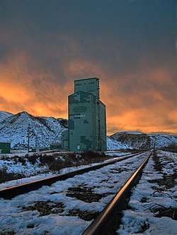 Grain elevator and tracks in Rosedale | |
 Location of Rosedale in Alberta | |
| Coordinates: 51°25′01″N 112°37′48″W / 51.417°N 112.630°WCoordinates: 51°25′01″N 112°37′48″W / 51.417°N 112.630°W | |
| Country |
|
| Province |
|
| Census division | No. 5 |
| Municipality | Town of Drumheller |
| Government[1] | |
| • Mayor | Heather Colberg |
| • Governing body |
Drumheller Town Council
|
| Area[2] | |
| • Total | 1.98 km2 (0.76 sq mi) |
| Population (2011)[2] | |
| • Total | 335 |
| • Density | 170/km2 (440/sq mi) |
| • Dwellings | 152 |
| Time zone | UTC-7 (MST) |
Rosedale is a community within the Town of Drumheller, Alberta, Canada. It was previously a hamlet within the former Municipal District (MD) of Badlands No. 7[3] prior to the MD's amalgamation with the former City of Drumheller on January 1, 1998.[4] It is also recognized as a designated place by Statistics Canada.[2]
Rosedale is located at the intersection of Highway 10/Highway 56 and Highway 10X, approximately 8 km (5.0 mi) southeast of Drumheller's main townsite and 107 km (66 mi) northeast of Calgary. It lies at the confluence of the Red Deer River and the Rosebud River. The community is within census division No. 5 and in the federal riding of Crowfoot.
Demographics
As a designated place in the 2016 Census of Population conducted by Statistics Canada, Rosedale recorded a population of 313 living in 141 of its 152 total private dwellings, a change of −6.6% from its 2011 population of 335. With a land area of 1.94 km2 (0.75 sq mi), it had a population density of 161.3/km2 (417.9/sq mi) in 2016.[5]
As a designated place in the 2011 Census, Rosedale had a population of 335 living in 140 of its 152 total dwellings, a 4.7% change from its 2006 population of 320. With a land area of 1.98 km2 (0.76 sq mi), it had a population density of 169.2/km2 (438.2/sq mi) in 2011.[2]
Attractions
Rosedale was home to a variety of coal mines before their closure in the 1970s.[6] The 117 meters (384 ft) long Star Mine Suspension Bridge built in 1931 over the Red Deer River used to connect the settlement with coal mines established on the opposite side of the river.[7] It was rebuilt in 1958,[8] and now serves as a tourist attraction. A miner memorial is also located in Rosedale.
See also
References
- ↑ "Municipal Officials Search". Alberta Municipal Affairs. September 22, 2017. Retrieved September 25, 2017.
- 1 2 3 4 "Population and dwelling counts, for Canada, provinces and territories, and designated places, 2011 and 2006 censuses (Alberta)". Statistics Canada. 2012-02-08. Retrieved 2012-04-07.
- ↑ "Town of Drumheller Municipal Development Plan: Volume 1 Background Study" (PDF). Town of Drumheller and Palliser Regional Municipal Services. April 21, 2008. p. 5. Retrieved October 10, 2013.
- ↑ "Location and History Profile: Town of Drumheller". Alberta Municipal Affairs. October 4, 2013. Retrieved October 10, 2013.
- ↑ "Population and dwelling counts, for Canada, provinces and territories, and designated places, 2016 and 2011 censuses – 100% data (Alberta)". Statistics Canada. February 8, 2017. Retrieved February 13, 2017.
- ↑ Coal Mining in Western Canada. "Drumheller Valley - Rosedale". Archived from the original on 2009-10-01. Retrieved 2009-10-11.
- ↑ Travel Drumheller. "Communities surrounding Drumheller in the Canadian Badlands". Retrieved 2009-10-13.
- ↑ Bridgemeiser. "1931 Star Mine (Rosedale Swinging)". Retrieved 2009-10-11.