Mackenzie Highway
| |||||||||
|---|---|---|---|---|---|---|---|---|---|
|
Alberta Highway 35 Northwest Territories Highway 1 | |||||||||
| Route information | |||||||||
| Length | 1,160 km (720 mi) | ||||||||
| Alberta | |||||||||
| Length | 469 km (291 mi) | ||||||||
| South end |
| ||||||||
| Major junctions |
| ||||||||
| Northwest Territories | |||||||||
| Length | 690 km (430 mi) | ||||||||
| Major junctions |
| ||||||||
| North end | Wrigley | ||||||||
| Highway system | |||||||||
|
Provincial highways in Alberta Northwest Territories highways
| |||||||||
The Mackenzie Highway is a Canadian highway in northern Alberta and the Northwest Territories. It begins as Alberta Highway 2 at Mile Zero in Grimshaw, Alberta.[1] After the first 4.0 km (2.5 mi), it becomes Alberta Highway 35 for the balance of its length through Alberta and then becomes Northwest Territories Highway 1.
Route description
The Mackenzie Highway is designated as part of Canada's National Highway System, holding core route status from its terminus at Grimshaw to its intersection with the Yellowknife Highway, and northern/remote route status for the remainder of the route to its northern terminus at Wrigley.
Originally begun in 1938, prior to World War II, the project was abandoned at the outbreak of war, then resumed in the late 1940s and completed to Hay River, Northwest Territories in 1948/1949, though some sections, particularly in the vicinity of Steen River, remained difficult.
In 1960, it was extended from Enterprise, approximately 39 km (24 mi) south of Hay River, to the northwest, then north past Fort Providence to Behchoko (at the time, known as Rae-Edzo) and southeast to the City of Yellowknife, which became the capital of the Northwest Territories in 1967. Much of this extension is now known as Northwest Territories Highway 3, the Yellowknife Highway. The 39 km (24 mi) stretch from Enterprise to Hay River is Northwest Territories Highway 2.
In approximately 1970, the highway was extended west from what is now the southern terminus of Highway 3 to reach Fort Simpson, and in 1971, when the section to Fort Simpson was opened to traffic, work began to prepare a road grade from there to Wrigley, but the work was abandoned. This roadway, which starts at a junction 3.5 km (2.2 mi) from the island that "downtown" Fort Simpson is situated on, was finally made usable in 1994, and includes the N'dulee ferry and ice crossings.
There are social and economic studies being done on the extension of the highway north from Wrigley to join the Dempster Highway; the N.W.T. government has completed 34 bridges across all but six of the widest river crossings, serving the ice road and awaiting the all-weather route.[2] In June 2018, an announcement of $140 million funding would result in a bridge over Great Bear River and extend the Mackenzie Highway's all-weather road north by 15 km to Mount Gaudet.[3]
Just east of Fort Simpson's airport, the highway crosses the Liard River by ferry (summer) and ice bridge (winter). 45 km (28 mi) further east of this crossing, the location known as Checkpoint is the site of a former gas station at the junction with the Liard Highway (Northwest Territories Highway 7, British Columbia Highway 77) from Fort Nelson, British Columbia.
Major intersections
| Province / Territory | Municipality / Region | Location | km[4] | mi | Destinations | Notes | |
|---|---|---|---|---|---|---|---|
| Alberta | M.D. of Peace No. 135 | Grimshaw | 0 | 0.0 | Mile Zero Mackenzie Highway. | ||
| | 4 | 2.5 | Hwy 2 branches east. Mackenzie Hwy follows Hwy 35. South end of National Highway System Core Route. | ||||
| South terminus of | |||||||
| Northern Lights | | 13 | 8.1 | ||||
| | 20 | 12 | |||||
| Dixonville | 39 | 24 | |||||
| | 62 | 39 | |||||
| Manning | 82 | 51 | |||||
| | 120 | 75 | |||||
| | 179 | 111 | South end of Hwy 695 concurrency. | ||||
| | 186 | 116 | North end of Hwy 695 concurrency. | ||||
| | 219 | 136 | |||||
| Mackenzie | High Level | 278 | 173 | South end of Hwy 58 concurrency. | |||
| 279 | 173 | North end of Hwy 58 concurrency. | |||||
| | 363 | 226 | Crosses Hay River | ||||
| | 364 | 226 | Zama Road – Zama City | ||||
| 60th parallel | 469 0 | 291 0.0 | Alberta – Northwest Territories border North terminus of | ||||
| Northwest Territories | South Slave | Enterprise | 83 | 52 | Hwy 1 turns west. | ||
| | 167 | 104 | Kakisa Access Road – Kakisa | ||||
| | 168 | 104 | Crosses Kakisa River | ||||
| | 186 | 116 | North end of National Highway System Core Route, south end of Northern & Remote Route. | ||||
| Dehcho | | 324 | 201 | Crosses Trout River | |||
| | 376 | 234 | Jean Marie River Access Road – Jean Marie River | ||||
| Checkpoint | 412 | 256 | Hwy 1 turns north. | ||||
| | 457 | 284 | Crosses Liard River | ||||
| Fort Simpson | 472 | 293 | Fort Simpson Access Road | Hwy 1 branches northwest. | |||
| | 489 | 304 | Crosses Martin River | ||||
| N’Dulee Crossing | 548 | 341 | Crosses Mackenzie River | ||||
| | 627 | 390 | Crosses Willowlake River | ||||
| Wrigley | 690 | 430 | Northern terminus of | ||||
| Continues as winter road to Norman Wells, Fort Good Hope, and Colville Lake | |||||||
1.000 mi = 1.609 km; 1.000 km = 0.621 mi
| |||||||
Photo gallery

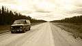 The Mackenzie Highway
61°8′35″N 119°10′28″W / 61.14306°N 119.17444°W
References
- ↑ "Discover the Peace Country – Grimshaw". Retrieved 2010-12-31.
- ↑ "Executive Summary of the Benefit Cost and Economic Impact Analysis Mackenzie Valley Highway Extension" (PDF). NWT DoT. 1999. Retrieved 2011-01-06.
- ↑ "Mackenzie Valley Highway project to get $102M boost from federal gov't". CBC News. 2018-06-27.
- ↑ "Google Maps". Google Maps. Retrieved 15 July 2016.
- 1 2 "Highway 1". Department of Transportation. Government of Northwest Territories. Retrieved 15 July 2016.
External links
- Highway 1 - Northwest Territories Department of Transportation
- 1948 Mackenzie Highway, Grimshaw to Hay River
- Mackenzie Valley Highway to Tuktoyaktuk
| Highways | ||
|---|---|---|
| Other roads |
| |