Alabel, Sarangani
| Alabel | ||
|---|---|---|
| Municipality | ||
| Municipality of Alabel | ||
 Municipal Hall | ||
| ||
 Map of Sarangani with Alabel highlighted | ||
.svg.png) Alabel Location within the Philippines | ||
| Coordinates: 6°08′N 125°17′E / 6.13°N 125.28°ECoordinates: 6°08′N 125°17′E / 6.13°N 125.28°E | ||
| Country |
| |
| Region | Soccsksargen (Region XII) | |
| Province | Sarangani | |
| District | Lone District | |
| Barangays | 13 (see Barangays) | |
| Government [1] | ||
| • Type | Sangguniang Bayan | |
| • Mayor | Vic Paul Molina Salarda, MPA | |
| • Vice Mayor | Ronnel Saldua Español, MPA | |
| • Congressman | Rogelio D. Pacquiao | |
| • Electorate | 45,780 voters (2016) | |
| Area [2] | ||
| • Total | 510.98 km2 (197.29 sq mi) | |
| Population (2015 census)[3] | ||
| • Total | 80,359 | |
| • Density | 160/km2 (410/sq mi) | |
| Time zone | UTC+8 (PST) | |
| ZIP code | 9501 | |
| PSGC | 128001000 | |
| IDD : area code | +63 (0)83 | |
| Climate type | Tropical rainforest climate | |
| Income class | 1st municipal income class | |
| Revenue (₱) | 219,384,734.41 (2016) | |
| Native languages |
Cebuano Tboli Maguindanao language Blaan language Tagalog | |
| Festival | Kasadyaan Festival | |
| Website |
www | |
Alabel, officially the Municipality of Alabel, is a 1st class municipality and capital of the province of Sarangani, Philippines. According to the 2015 census, it has a population of 80,359 people.[3]
History
The first Mayor of Alabel is Lucio Alaba. The word Alabel is derived from the combined surnames of Alaba and Beldad.
The former President Corazon Aquino landed in Barangay Spring in 1988 during her visit in South Cotabato. The President together with her team visited Mindanao to watch the solar eclipse. Astronomers and other tourists watched the said celestial phenomena.
President Corazon Aquino and Defense Secretary Fidel Ramos were among the estimated 20,000 sight-seers and scientists who jammed the cities of Davao and General Santos for the event, seen as a total eclipse only in the nation's extreme southern tip and parts of Indonesia.It was the first total eclipse seen in the Philippines since 1955. Another is not expected until the year 2042.[4]
Martial Law
The so-called battle of Ilaga, Muslim and Lumads happened in Alabel during Marcos Regime in 1974. Many Lumads and Muslim was killed and murdered by paramilitary groups called ilaga (Ilonggo term for rats).
Civilian fled and evacuated in Dadiangas now General Santos City in order to survive from brutalities in Alabel while some transfer and went home to their place of origin in Visayan Islands.
Festival and celebrations
The Municipality of Alabel celebrates it Foundation anniversary every 10th day of September. It is an annual celebration to commemorate the founding of the town. Together the people of Alabel also celebrates the Kasadyaan Festival. Kasadyaan means bliss, to gave an ideal representation of what is Alabel.
The annual Patronal Fiesta in Alabel is celebrated every May 15. It is feast day of San Isidro Labrador, the town's patron saint and the patron saint of farmers.[5]
Barangays
Alabel is politically subdivided into 13 barangays.
Poblacion, the town's capital
The current Punong Barangay of Poblacion, Alabel is Herculano Lacaba. Poblacion is divided into 25 purok.
Education
Alabel National High School is considered the seat of excellence in secondary education in the entire Sarangani Province. Producing highly competitive and world-class citizenry. ANHS was one of the many Tech-Voc School in the Province. It was established in 1960's as community high school.[6]
The current vice mayor of Alabel, Ronnel Saldua Espaňol, MPA is one of the alumni of ANHS in the year 1992.
Alabel National Science High School, the only regional science high school in SOCCSKSARGEN is located in Alabel,inside the Provincial Capitol Complex.[7]
List of Alabel Mayor

- Lucio Alaba
- Hernando Sibugan
- Narciso Ra. Grafilo III
- Corazon Sunga Grafilo
- Vic Paul M. Salarda
Demographics
| Population census of Alabel | ||
|---|---|---|
| Year | Pop. | ±% p.a. |
| 1990 | 40,730 | — |
| 1995 | 46,527 | +2.52% |
| 2000 | 60,779 | +5.90% |
| 2007 | 71,872 | +2.34% |
| 2010 | 75,477 | +1.80% |
| 2015 | 80,359 | +1.20% |
| Source: Philippine Statistics Authority[3] [8] [9] [10] | ||
Economy
Alabel is largely based on agriculture with a high level production of dried coconut meat. Animal husbandry is the second biggest income earner, notably cattle farming. Other agricultural products are coconuts, maize, sugarcane, bananas, pineapples, cotton, mangoes; goat farming, pork, eggs, beef; fish; charcoal; coconut weaving. It is adjacent to the highly urbanized sea port city of General Santos.
The economy has accelerated in the past decade driven by advances in global communication technology and the finishing of a modern highway that tremendously improved trade and transport.
Health
Alabel Municipal Health Office was headed by Dr. Honorato Fabio. The Alabel Birthing Home was built to supplement the need of maternal health services.
Tourism
Alabel is known for its beaches and agricultural lands.
- Ladol Beach
- Half Moon (known as Kawas) Beach
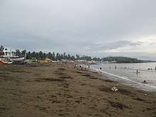
Alabel are rich of natural resources.
References
- ↑ "Municipality". Quezon City, Philippines: Department of the Interior and Local Government. Retrieved 31 May 2013.
- ↑ "Province: Sarangani". PSGC Interactive. Quezon City, Philippines: Philippine Statistics Authority. Retrieved 12 November 2016.
- 1 2 3 Census of Population (2015). "Region XII (Soccsksargen)". Total Population by Province, City, Municipality and Barangay. PSA. Retrieved 20 June 2016.
- ↑ https://www.upi.com/Archives/1988/03/18/Dogs-howl-cocks-crow-at-eclipse-darkened-daytime-sky/2542574664400/
- ↑ https://www.zamboanga.com/z/index.php?title=Alabel,_Sarangani,_Philippines
- ↑ https://alabelnhs304518.weebly.com/
- ↑ http://rshsxii.edu.ph/
- ↑ Census of Population and Housing (2010). "Region XII (Soccsksargen)". Total Population by Province, City, Municipality and Barangay. NSO. Retrieved 29 June 2016.
- ↑ Censuses of Population (1903–2007). "Region XII (Soccsksargen)". Table 1. Population Enumerated in Various Censuses by Province/Highly Urbanized City: 1903 to 2007. NSO.
- ↑ "Province of Sarangani". Municipality Population Data. Local Water Utilities Administration Research Division. Retrieved 17 December 2016.
External links
| Wikimedia Commons has media related to Alabel, Sarangani. |
- Alabel Municipal Profile at the Province of Sarangani Official Website
- Philippine Standard Geographic Code
- Philippine Census Information
- Local Governance Performance Management System
Places adjacent to Alabel, Sarangani | |
|---|---|