Arrondissement of Saint-Dié-des-Vosges
| Saint-Dié-des-Vosges | |
|---|---|
| Arrondissement | |
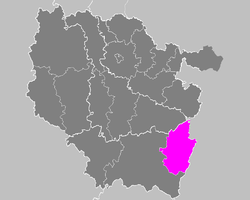 Location of Saint-Dié-des-Vosges in Lorraine | |
| Country | France |
| Region | Grand Est |
| Department | Vosges |
| Communes | 88 |
| Subprefecture | Saint-Dié-des-Vosges |
| Area¹ | |
| • Total | 1,166 km2 (450 sq mi) |
| Population (2013) | |
| • Total | 92,701 |
| • Density | 80/km2 (210/sq mi) |
| ¹ French Land Register data, which exclude lakes, ponds, and glaciers larger than 1 km² as well as the estuaries of rivers. | |
| Part of the series on |
| Lorraine |
|---|
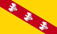 Flag of Lorraine since the 13th century |
|
|
Administrative divisions
|
|
Lorraine in the EU |
|
Related topics |
The arrondissement of Saint-Dié-des-Vosges is an arrondissement of France in the Vosges department in the Grand Est région. It has 88 communes.
Composition
Cantons
The cantons of the arrondissement of Saint-Dié-des-Vosghttps://en.wikipedia.org/wiki/Astronomer%27s_Telegrames are:
- Bruyères (partly)
- Gérardmer
- Raon-l'Étape (partly)
- Saint-Dié-des-Vosges-1 (partly)
- Saint-Dié-des-Vosges-2
Communes
The communes of the arrondissement of Saint-Dié-des-Vosges, and their codes, are:
- Allarmont (88005)
- Anould (88009)
- Arrentès-de-Corcieux (88014)
- Ban-de-Laveline (88032)
- Ban-de-Sapt (88033)
- Ban-sur-Meurthe-Clefcy (88106)
- Barbey-Seroux (88035)
- Belmont-sur-Buttant (88050)
- Belval (88053)
- Bertrimoutier (88054)
- Le Beulay (88057)
- Biffontaine (88059)
- Bois-de-Champ (88064)
- La Bourgonce (88068)
- Brouvelieures (88076)
- Celles-sur-Plaine (88082)
- Champdray (88085)
- La Chapelle-devant-Bruyères (88089)
- Châtas (88093)
- Coinches (88111)
- Combrimont (88113)
- Corcieux (88115)
- La Croix-aux-Mines (88120)
- Denipaire (88128)
- Domfaing (88145)
- Entre-deux-Eaux (88159)
- Étival-Clairefontaine (88165)
- Fraize (88181)
- Frapelle (88182)
- Fremifontaine (88184)
- Gemaingoutte (88193)
- Gérardmer (88196)
- Gerbépal (88198)
- La Grande-Fosse (88213)
- Grandrupt (88215)
- Granges-Aumontzey (88218)
- Herpelmont (88240)
- La Houssière (88244)
- Hurbache (88245)
- Jussarupt (88256)
- Lesseux (88268)
- Liézey (88269)
- Lubine (88275)
- Lusse (88276)
- Luvigny (88277)
- Mandray (88284)
- Ménil-de-Senones (88300)
- Le Mont (88306)
- Mortagne (88315)
- Moussey (88317)
- Moyenmoutier (88319)
- Nayemont-les-Fosses (88320)
- Neuvillers-sur-Fave (88326)
- Nompatelize (88328)
- Pair-et-Grandrupt (88341)
- La Petite-Fosse (88345)
- La Petite-Raon (88346)
- Plainfaing (88349)
- Les Poulières (88356)
- Provenchères-et-Colroy (88361)
- Le Puid (88362)
- Raon-l'Étape (88372)
- Raon-sur-Plaine (88373)
- Raves (88375)
- Rehaupal (88380)
- Remomeix (88386)
- Les Rouges-Eaux (88398)
- Saint-Dié-des-Vosges (88413)
- Sainte-Marguerite (88424)
- Saint-Jean-d'Ormont (88419)
- Saint-Léonard (88423)
- Saint-Michel-sur-Meurthe (88428)
- Saint-Remy (88435)
- Saint-Stail (88436)
- La Salle (88438)
- Le Saulcy (88444)
- Saulcy-sur-Meurthe (88445)
- Senones (88451)
- Taintrux (88463)
- Le Valtin (88492)
- Le Vermont (88501)
- Vervezelle (88502)
- Vexaincourt (88503)
- Vienville (88505)
- Vieux-Moulin (88506)
- La Voivre (88519)
- Wisembach (88526)
- Xonrupt-Longemer (88531)
External links
This article is issued from
Wikipedia.
The text is licensed under Creative Commons - Attribution - Sharealike.
Additional terms may apply for the media files.