Northamptonshire
Northamptonshire is een shire-graafschap (non-metropolitan county OF county) in de Engelse regio East Midlands en telt 741.209 inwoners. De oppervlakte bedraagt 2367 km2. De graafschaphoofdstad is Northampton.
| Niet-stedelijk graafschap in Engeland | |||
| |||
 | |||
| Situering | |||
| Land | Engeland | ||
| Status | shire county | ||
| Regio | East Midlands | ||
| Coördinaten | 52°17'NB, 0°50'WL | ||
| Algemeen | |||
| Oppervlakte | 2364,0051[1] km² | ||
| Inwoners (2017[2]) | 741.209 (313 inw./km²) | ||
| ONS-code | 34 | ||
| |||


Northamptonshire grenst aan Warwickshire, Leicestershire, Rutland, Cambridgeshire (inclusief Peterborough), Bedfordshire, Buckinghamshire (inclusief de Borough Milton Keynes).
Demografie
Van de bevolking is 14,2 % ouder dan 65 jaar. De werkloosheid bedraagt 2,8 % van de beroepsbevolking (cijfers volkstelling 2001).
Het aantal inwoners steeg van ongeveer 584.100 in 1991 naar 629.676 in 2001.
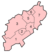
Districten
 |
Belangrijkste plaatsen
- Brackley
- Braunston
- Brixworth
- Corby
- Daventry
- Kettering
- Long Buckby
- Naseby
- Northampton
- Oundle
- Pitsford
- Raunds
- Rushden
- Silverstone
- Towcester
- Thrapston
- Weedon Bec
- Wellingborough
| Bronnen, noten en/of referenties |
| Ceremoniële graafschappen van Engeland sinds 1997 |
|---|
|
Bedfordshire · Berkshire · City of Bristol · Buckinghamshire · Cambridgeshire · Cheshire · Cornwall · Cumbria · Derbyshire · Devon · Dorset · Durham · East Riding of Yorkshire · East Sussex · Essex · Gloucestershire · Greater London · Greater Manchester · Hampshire · Herefordshire · Hertfordshire · Isle of Wight · Kent · Lancashire · Leicestershire · Lincolnshire · City of London · Merseyside · Norfolk · Northamptonshire · Northumberland · North Yorkshire · Nottinghamshire · Oxfordshire · Rutland · Shropshire · Somerset · South Yorkshire · Staffordshire · Suffolk · Surrey · Tyne and Wear · Warwickshire · West Midlands · West Sussex · West Yorkshire · Wiltshire · Worcestershire Overig: Stedelijke en niet-stedelijke graafschappen · Traditionele graafschappen |
| Traditionele graafschappen van Engeland |
|---|
|
Bedfordshire · Berkshire · Buckinghamshire · Cambridgeshire · Cheshire · Cornwall · Cumberland · Derbyshire · Devon · Dorset · Durham · Essex · Gloucestershire · Hampshire · Herefordshire · Hertfordshire · Huntingdonshire · Kent · Lancashire · Lincolnshire · Leicestershire · Middlesex · Norfolk · Northamptonshire · Northumberland · Nottinghamshire · Oxfordshire · Rutland · Shropshire · Somerset · Staffordshire · Suffolk · Surrey · Sussex · Warwickshire · Westmorland · Wiltshire · Worcestershire · Yorkshire Overig: Stedelijke en niet-stedelijke graafschappen · Traditionele graafschappen |