Durham (graafschap)
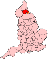
Durham is een ceremonieel graafschap, een unitary authority en een district in de Engelse regio North East England en telt 523.662 inwoners. De oppervlakte bedraagt 2722 km2.
| Unitaire autoriteit in Engeland | |||
| |||
 | |||
| Situering | |||
| Land | Engeland | ||
| Regio | North East England | ||
| Coördinaten | 54°40'NB, 1°50'WL | ||
| Algemeen | |||
| Oppervlakte | 2721,9661[1] km² | ||
| Inwoners (2017[2]) | 523.662 (235 inw./km²) | ||
| ONS-code | E06000047 | ||
| |||

Graafschaphoofdstad is Durham.
Demografie
Van de bevolking is 16,5% ouder dan 65 jaar. De werkloosheid bedraagt 3,7% van de beroepsbevolking (cijfers volkstelling 2001).
Het aantal inwoners daalde van ongeveer 501.500 in 1991 naar 493.470 in 2001.
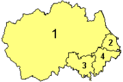
Districten
 |
| Bronnen, noten en/of referenties |
| Traditionele graafschappen van Engeland |
|---|
|
Bedfordshire · Berkshire · Buckinghamshire · Cambridgeshire · Cheshire · Cornwall · Cumberland · Derbyshire · Devon · Dorset · Durham · Essex · Gloucestershire · Hampshire · Herefordshire · Hertfordshire · Huntingdonshire · Kent · Lancashire · Lincolnshire · Leicestershire · Middlesex · Norfolk · Northamptonshire · Northumberland · Nottinghamshire · Oxfordshire · Rutland · Shropshire · Somerset · Staffordshire · Suffolk · Surrey · Sussex · Warwickshire · Westmorland · Wiltshire · Worcestershire · Yorkshire Overig: Stedelijke en niet-stedelijke graafschappen · Traditionele graafschappen |
| Ceremoniële graafschappen van Engeland sinds 1997 |
|---|
|
Bedfordshire · Berkshire · City of Bristol · Buckinghamshire · Cambridgeshire · Cheshire · Cornwall · Cumbria · Derbyshire · Devon · Dorset · Durham · East Riding of Yorkshire · East Sussex · Essex · Gloucestershire · Greater London · Greater Manchester · Hampshire · Herefordshire · Hertfordshire · Isle of Wight · Kent · Lancashire · Leicestershire · Lincolnshire · City of London · Merseyside · Norfolk · Northamptonshire · Northumberland · North Yorkshire · Nottinghamshire · Oxfordshire · Rutland · Shropshire · Somerset · South Yorkshire · Staffordshire · Suffolk · Surrey · Tyne and Wear · Warwickshire · West Midlands · West Sussex · West Yorkshire · Wiltshire · Worcestershire Overig: Stedelijke en niet-stedelijke graafschappen · Traditionele graafschappen |
| Zie de categorie County Durham van Wikimedia Commons voor mediabestanden over dit onderwerp. |