South Gloucestershire
South Gloucestershire is een unitary authority en een district in de Engelse regio South West England, het ceremoniële graafschap Gloucestershire en telt 283.000 inwoners. De oppervlakte bedraagt 497 km2.
| Unitaire autoriteit in Engeland | |||
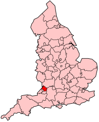 | |||
| Situering | |||
| Land | Engeland | ||
| Regio | South West England | ||
| Coördinaten | 51°28'46"NB, 2°22'49"WL | ||
| Algemeen | |||
| Oppervlakte | 496,9473[1] km² | ||
| Inwoners (2018[2]) | 282644 (569 inw./km²) | ||
| ONS-code | E06000025 | ||
| |||
Demografie
Van de bevolking is 14,4 % ouder dan 65 jaar. De werkloosheid bedraagt 1,8 % van de beroepsbevolking (cijfers volkstelling 2001).
Het aantal inwoners steeg van ongeveer 222.200 in 1991 naar 245.641 in 2001.
Civil parishes in district South Gloucestershire
Acton Turville, Almondsbury, Alveston, Aust, Badminton, Bitton, Bradley Stoke, Charfield, Cold Ashton, Cromhall, Dodington, Downend and Bromley Heath, Doynton, Dyrham and Hinton, Falfield, Filton, Frampton Cotterell, Hanham, Hanham Abbots, Hawkesbury, Hill, Horton, Iron Acton, Little Sodbury, Mangotsfield Rural, Marshfield, Oldbury-upon-Severn, Oldland, Olveston, Patchway, Pilning and Severn Beach, Pucklechurch, Rangeworthy, Rockhampton, Siston, Sodbury, Stoke Gifford, Thornbury, Tormarton, Tortworth, Tytherington, Westerleigh, Wick and Abson, Wickwar, Winterbourne, Yate.
Plaatsen in district South Gloucestershire
Zie ook
Bronnen, noten en/of referenties
|