Bath and North East Somerset
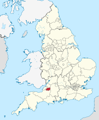
Bath and North East Somerset (afgekort BANES) is een unitary authority en een district in de Engelse regio South West England en telt 192.000 inwoners. De oppervlakte bedraagt 346 km2.
| Unitaire autoriteit in Engeland | |||
 | |||
| Situering | |||
| Land | Engeland | ||
| Regio | South West England | ||
| Coördinaten | 51°23'24"NB, 2°19'12"WL | ||
| Algemeen | |||
| Oppervlakte | 345,8786[1] km² | ||
| Inwoners (2018[2]) | 192106 (555 inw./km²) | ||
| Hoofdplaats ONS-code | Bath E06000022 | ||
| |||
Demografie
Van de bevolking is 17,8 % ouder dan 65 jaar. De werkloosheid bedraagt 2,0 % van de beroepsbevolking (cijfers volkstelling 2001).
Het aantal inwoners steeg van ongeveer 163.100 in 1991 naar 169.040 in 2001.
Civil parishes in district Bath and North East Somerset
Bathampton, Batheaston, Bathford, Cameley, Camerton, Charlcombe, Chelwood, Chew Magna, Chew Stoke, Claverton, Clutton, Combe Hay, Compton Dando, Compton Martin, Corston, Dunkerton, East Harptree, Englishcombe, Farmborough, Farrington Gurney, Freshford, High Littleton, Hinton Blewett, Hinton Charterhouse, Kelston, Keynsham, Marksbury, Midsomer Norton, Monkton Combe, Nempnett Thrubwell, Newton St. Loe, North Stoke, Norton Malreward, Paulton, Peasedown St. John, Priston, Publow, Radstock, Saltford, Shoscombe, Saltford, Shoscombe, Southstoke, St. Catherine, Stanton Drew, Stowey-Sutton, Swainswick, Timsbury, Ubley, Wellow, West Harptree, Westfield.
Plaatsen in district Bath and North East Somerset
Bath, Bishop Sutton, Norton Radstock.
Bronnen, noten en/of referenties
|