Daventry (district)
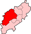
Daventry is een Engels district in het shire-graafschap (non-metropolitan county OF county) Northamptonshire en telt 84.000 inwoners. Hoofdplaats is Daventry.
| Niet-metropolitaans district in Engeland | |||
  | |||
| Situering | |||
| Land | Engeland | ||
| County | Northamptonshire | ||
| Regio | East Midlands | ||
| Coördinaten | 52°18'NB, 1°3'WL | ||
| Algemeen | |||
| Oppervlakte | 662,6157[1] km² | ||
| Inwoners (2018[2]) | 84484 (128 inw./km²) | ||
| ONS-code | E07000151 | ||
| |||
Civil parishes in district Daventry
Althorp, Arthingworth, Ashby St Ledgers, Badby, Barby, Boughton, Braunston, Brington, Brixworth, Brockhall, Byfield, Canons Ashby, Catesby, Charwelton, Church with Chapel Brampton, Clay Coton, Clipston, Cold Ashby, Cottesbrooke, Creaton, Crick, Daventry, Dodford, Draughton, East Farndon, East Haddon, Elkington, Everdon, Farthingstone, Fawsley, Flore, Great Oxendon, Guilsborough, Hannington, Harlestone, Haselbech, Hellidon, Holcot, Holdenby, Hollowell, Kelmarsh, Kilsby, Lamport, Lilbourne, Long Buckby, Maidwell, Marston Trussell, Moulton, Naseby, Newnham, Norton, Old, Overstone, Pitsford, Preston Capes, Ravensthorpe, Scaldwell, Sibbertoft, Spratton, Stanford, Staverton, Stowe IX Churches, Sulby, Thornby, Walgrave, Watford, Weedon Bec, Welford, Welton, West Haddon, Whilton, Winwick, Woodford cum Membris, Yelvertoft.
Bronnen, noten en/of referenties
|