East Riding of Yorkshire
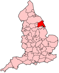
East Riding of Yorkshire is een unitary authority in de Engelse regio Yorkshire and the Humber en telt 340.000 inwoners. De oppervlakte bedraagt 2406 km2.
| Unitaire autoriteit in Engeland | |||
| |||
 | |||
| Situering | |||
| Land | Engeland | ||
| Regio | Yorkshire and the Humber | ||
| Coördinaten | 53°55'0"NB, 0°30'0"WL | ||
| Algemeen | |||
| Oppervlakte | 2405,3217[1] km² | ||
| Inwoners (2018[2]) | 339614 (141 inw./km²) | ||
| ONS-code | E06000011 | ||
| |||

East Riding of Yorkshire grenst met drie zijden aan Kingston upon Hull, een stad en unitary authority.
Administratieve hoofdplaats is Beverley.
De officiële vlag van East Riding of Yorkshire, sinds 22 april 2013, bevat twee verticale balken van blauw en groen, met de witte roos van het Huis York.[3]
Demografie
Van de bevolking is 18,4 % ouder dan 65 jaar. De werkloosheid bedraagt 3,0 % van de beroepsbevolking (cijfers volkstelling 2001).
Het aantal inwoners steeg van ongeveer 294.400 in 1991 naar 314.113 in 2001.
Civil parishes in district East Riding of Yorkshire
Airmyn, Aldbrough, Allerthorpe, Anlaby with Anlaby Common, Asselby, Atwick, Bainton, Barmby Moor, Barmby on the Marsh, Barmston, Beeford, Bempton, Beswick, Beverley, Bewholme, Bielby, Bilton, Bishop Burton, Bishop Wilton, Blacktoft, Boynton, Brandesburton, Brantingham, Bridlington, Broomfleet, Bubwith, Bugthorpe, Burstwick, Burton Agnes, Burton Constable, Burton Fleming, Burton Pidsea, Carnaby, Catton, Catwick, Cherry Burton, Coniston, Cottam, Cottingham, Cottingwith, Dalton Holme, Driffield, Easington, East Garton, Eastrington, Ellerby, Ellerker, Ellerton, Elloughton-cum-Brough, Elstronwick, Etton, Everingham, Fangfoss, Fimber, Flamborough, Foggathorpe, Foston, Fridaythorpe, Full Sutton, Garton, Gilberdyke, Goodmanham, Goole, Goole Fields, Gowdall, Grindale, Halsham, Harpham, Hatfield, Hayton, Hedon, Hessle, Hollym, Holme upon Spalding Moor, Holmpton, Hook, Hornsea, Hotham, Howden, Huggate, Humbleton, Hutton Cranswick, Kelk, Keyingham, Kilham, Kilpin, Kirby Underdale, Kirk Ella, Kirkburn, Langtoft, Laxton, Leconfield, Leven, Lockington, Londesborough, Lund, Mappleton, Market Weighton, Melbourne, Middleton, Millington, Molescroft, Nafferton, Newbald, Newport, Newton on Derwent, North Cave, North Dalton, North Ferriby, North Frodingham, Nunburnholme, Ottringham, Patrington, Paull, Pocklington, Pollington, Preston, Rawcliffe, Reedness, Rimswell, Rise, Riston, Roos, Routh, Rowley, Rudston, Sancton, Seaton, Seaton Ross, Shiptonthorpe, Sigglesthorne, Skeffling, Skerne and Wansford, Skidby, Skipsea, Skirlaugh, Skirpenbeck, Sledmere, Snaith and Cowick, South Cave, South Cliffe, Spaldington, Sproatley, Stamford Bridge, Sunk Island, Sutton upon Derwent, Swanland, Swine, Swinefleet, Thorngumbald, Thornton, Thwing, Tibthorpe, Tickton, Twin Rivers, Ulrome, Walkington, Warter, Watton, Wawne, Welton, Welwick, Wetwang, Wilberfoss, Willerby, Withernsea, Withernwick, Wold Newton, Woodmansey, Wressle, Yapham.
Bronnen, noten en/of referenties
|
| Ceremoniële graafschappen van Engeland sinds 1997 |
|---|
|
Bedfordshire · Berkshire · City of Bristol · Buckinghamshire · Cambridgeshire · Cheshire · Cornwall · Cumbria · Derbyshire · Devon · Dorset · Durham · East Riding of Yorkshire · East Sussex · Essex · Gloucestershire · Greater London · Greater Manchester · Hampshire · Herefordshire · Hertfordshire · Isle of Wight · Kent · Lancashire · Leicestershire · Lincolnshire · City of London · Merseyside · Norfolk · Northamptonshire · Northumberland · North Yorkshire · Nottinghamshire · Oxfordshire · Rutland · Shropshire · Somerset · South Yorkshire · Staffordshire · Suffolk · Surrey · Tyne and Wear · Warwickshire · West Midlands · West Sussex · West Yorkshire · Wiltshire · Worcestershire Overig: Stedelijke en niet-stedelijke graafschappen · Traditionele graafschappen |
| Zie de categorie East Riding of Yorkshire van Wikimedia Commons voor mediabestanden over dit onderwerp. |