Darlington (Engeland)
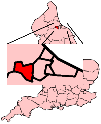
Darlington is een unitary authority en een district in de Engelse regio North East England en telt 107.000 inwoners. De oppervlakte bedraagt 197 km2. Hoofdplaats is de stad Darlington.
| Unitary authority in Engeland | |||
 | |||
| Situering | |||
| Land | Engeland | ||
| Regio | North East England | ||
| Coördinaten | 54°31'22"NB, 1°33'26"WL | ||
| Algemeen | |||
| Oppervlakte | 197,4758[1] km² | ||
| Inwoners (2018[2]) | 106566 (540 inw./km²) | ||
| Hoofdplaats ONS-code | Darlington E06000005 | ||
| |||
Vanuit ceremonieel oogpunt geldt het als onderdeel van het ceremoniële graafschap Durham.
Demografie
Van de bevolking is 17,0% ouder dan 65 jaar. De werkloosheid bedraagt 4,0% van de beroepsbevolking (cijfers volkstelling 2001).
Het aantal inwoners daalde van ongeveer 99.300 in 1991 naar 97.838 in 2001.
Geboren
- Anthony Havelock-Allan (1904-2003), filmproducent
- James Morrison (1986), Schots voetballer
Civil parishes in district Darlington
Archdeacon Newton, Barmpton, Bishopton, Brafferton, Coatham Mundeville, Denton, East and West Newbiggin, Great Burdon, Great Stainton, Heighington, High Coniscliffe, Houghton le Side, Hurworth, Killerby, Little Stainton, Low Coniscliffe and Merrybent, Low Dinsdale, Middleton St. George, Morton Palms, Neasham, Piercebridge, Sadberge, Sockburn, Summerhouse, Walworth, Whessoe.
Plaatsen district Darlington
Beaumont Hill, Blackwell, Haughton Le Skerne, Headlam, Houghton Bank, Middleton One Row, Oak Tree, Redworth, Walworth Gate.

Bronnen, noten en/of referenties
|
| Zie de categorie Darlington van Wikimedia Commons voor mediabestanden over dit onderwerp. |