Warwickshire
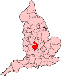
Warwickshire is een shire-graafschap (non-metropolitan county OF county) in de Engelse regio West Midlands en telt 564.562 inwoners. De oppervlakte bedraagt 1978 km2. De graafschapshoofdstad is Warwick.
| Niet-stedelijk graafschap in Engeland | |||
| |||
 | |||
| Situering | |||
| Land | Engeland | ||
| Status | shire county | ||
| Regio | West Midlands | ||
| Coördinaten | 52°20'NB, 1°35'WL | ||
| Algemeen | |||
| Oppervlakte | 1975,0787[1] km² | ||
| Inwoners (2017[2]) | 564.562 (285 inw./km²) | ||
| Hoofdplaats ONS-code | Warwick 44 | ||
| |||

Warwickshire grenst aan West Midlands en Staffordshire in het noordwesten, Leicestershire in het noordoosten, Northamptonshire in het oosten, Oxfordshire in het zuiden, en Gloucestershire en Worcestershire in het westen.
Demografie
Van de bevolking is 16,2 % ouder dan 65 jaar. De werkloosheid bedraagt 2,5 % van de beroepsbevolking (cijfers volkstelling 2001).
Het aantal inwoners steeg van ongeveer 487.100 in 1991 naar 505.860 in 2001.
Districten
| Districten | Detailkaart |
|---|---|
 |
Belangrijkste plaatsen
Afkomstig uit Warwickshire
- William Perkins (1558-1602), theoloog
- William Shakespeare (1564-1616), toneelschrijver
- Francis Willughby (1635-1672), natuuronderzoeker
- William Renshaw (1861-1904), tennisser
| Bronnen, noten en/of referenties |
| Ceremoniële graafschappen van Engeland sinds 1997 |
|---|
|
Bedfordshire · Berkshire · City of Bristol · Buckinghamshire · Cambridgeshire · Cheshire · Cornwall · Cumbria · Derbyshire · Devon · Dorset · Durham · East Riding of Yorkshire · East Sussex · Essex · Gloucestershire · Greater London · Greater Manchester · Hampshire · Herefordshire · Hertfordshire · Isle of Wight · Kent · Lancashire · Leicestershire · Lincolnshire · City of London · Merseyside · Norfolk · Northamptonshire · Northumberland · North Yorkshire · Nottinghamshire · Oxfordshire · Rutland · Shropshire · Somerset · South Yorkshire · Staffordshire · Suffolk · Surrey · Tyne and Wear · Warwickshire · West Midlands · West Sussex · West Yorkshire · Wiltshire · Worcestershire Overig: Stedelijke en niet-stedelijke graafschappen · Traditionele graafschappen |
| Traditionele graafschappen van Engeland |
|---|
|
Bedfordshire · Berkshire · Buckinghamshire · Cambridgeshire · Cheshire · Cornwall · Cumberland · Derbyshire · Devon · Dorset · Durham · Essex · Gloucestershire · Hampshire · Herefordshire · Hertfordshire · Huntingdonshire · Kent · Lancashire · Lincolnshire · Leicestershire · Middlesex · Norfolk · Northamptonshire · Northumberland · Nottinghamshire · Oxfordshire · Rutland · Shropshire · Somerset · Staffordshire · Suffolk · Surrey · Sussex · Warwickshire · Westmorland · Wiltshire · Worcestershire · Yorkshire Overig: Stedelijke en niet-stedelijke graafschappen · Traditionele graafschappen |