Greater Manchester
Greater Manchester is een gebied rond de stad Manchester en werd in de jaren 70 door de Britse regering gevormd. Deze stadsprovincie bestaat uit 10 zogenaamde boroughs.
| Stedelijk graafschap in Engeland | |||
 | |||
| Situering | |||
| Land | Engeland | ||
| Status | Stedelijk graafschap | ||
| Regio | North West England | ||
| Coördinaten | 53°30'0"NB, 2°19'0"WL | ||
| Algemeen | |||
| Oppervlakte | 1275,9821[1] km² | ||
| Inwoners (2001) | 2.482.328 (1945 inw./km²) | ||
| Hoofdplaats ONS-code | Manchester E11000001 | ||
| |||
De regio heeft zo'n 2,6 miljoen inwoners.
Boroughs
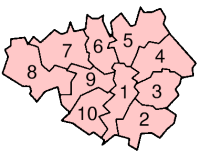
Greater Manchester bestaat uit de volgende boroughs (districten):
| Districten | Detailkaart |
|---|---|
 |
| Bronnen, noten en/of referenties |
| Ceremoniële graafschappen van Engeland sinds 1997 |
|---|
|
Bedfordshire · Berkshire · City of Bristol · Buckinghamshire · Cambridgeshire · Cheshire · Cornwall · Cumbria · Derbyshire · Devon · Dorset · Durham · East Riding of Yorkshire · East Sussex · Essex · Gloucestershire · Greater London · Greater Manchester · Hampshire · Herefordshire · Hertfordshire · Isle of Wight · Kent · Lancashire · Leicestershire · Lincolnshire · City of London · Merseyside · Norfolk · Northamptonshire · Northumberland · North Yorkshire · Nottinghamshire · Oxfordshire · Rutland · Shropshire · Somerset · South Yorkshire · Staffordshire · Suffolk · Surrey · Tyne and Wear · Warwickshire · West Midlands · West Sussex · West Yorkshire · Wiltshire · Worcestershire Overig: Stedelijke en niet-stedelijke graafschappen · Traditionele graafschappen |
| Zie de categorie Greater Manchester van Wikimedia Commons voor mediabestanden over dit onderwerp. |