Warrington (district)
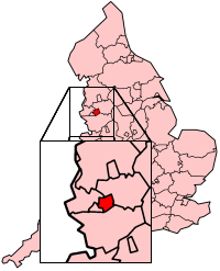
Warrington is een stad, een district en een unitary authority in de Engelse regio North West England, in het ceremoniële graafschap Cheshire en telt 209.704 inwoners. De oppervlakte bedraagt 181 km2.
| Unitaire autoriteit in Engeland | |||
 | |||
| Situering | |||
| Land | Engeland | ||
| Regio | North West England | ||
| Coördinaten | 53°23'20,00"NB, 2°35'46,00"WL | ||
| Algemeen | |||
| Oppervlakte | 180,6279[1] km² | ||
| Inwoners (2017[2]) | 209.704 (1161 inw./km²) | ||
| Hoofdplaats ONS-code | Warrington E06000007 | ||
| |||
Demografie
Van de bevolking is 14,2 % ouder dan 65 jaar. De werkloosheid bedraagt 2,9 % van de beroepsbevolking (cijfers volkstelling 2001).
Het aantal inwoners steeg van ongeveer 184.700 in 1991 naar 191.080 in 2001.
Plaatsen in district Warrington
Civil parishes in district Warrington
Appleton, Birchwood, Burtonwood and Westbrook, Croft, Cuerdley, Culcheth and Glazebury, Grappenhall and Thelwall, Great Sankey, Hatton, Lymm, Penketh, Poulton-with-Fearnhead, Rixton-with-Glazebrook, Stockton Heath, Stretton, Walton, Winwick, Woolston.
| Bronnen, noten en/of referenties
|
| Zie de categorie Borough of Warrington van Wikimedia Commons voor mediabestanden over dit onderwerp. |
This article is issued from
Wikipedia.
The text is licensed under Creative
Commons - Attribution - Sharealike.
Additional terms may apply for the media files.