Center Harbor, New Hampshire
Center Harbor is a town located in Belknap County, New Hampshire, United States. As of the 2010 census, the town had a total population of 1,096.[1] It is situated between Lake Winnipesaukee and Squam Lake.
Center Harbor, New Hampshire | |
|---|---|
Town | |
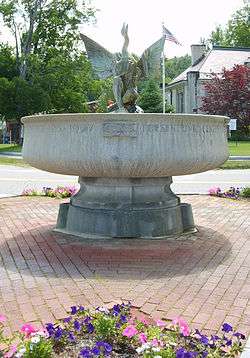 Kona Fountain in the center of town, 2007 | |
 Seal | |
| Motto(s): Winter Home of the M/S Mt. Washington | |
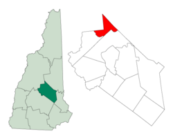 Location in Belknap County, New Hampshire | |
| Coordinates: 43°42′29″N 71°27′49″W | |
| Country | United States |
| State | New Hampshire |
| County | Belknap |
| Incorporated | 1797 |
| Government | |
| • Board of Selectmen | Harry Viens, Chair Richard Hanson Richard Drenkhahn |
| Area | |
| • Total | 16.5 sq mi (42.8 km2) |
| • Land | 13.4 sq mi (34.6 km2) |
| • Water | 3.2 sq mi (8.2 km2) 19.2% |
| Elevation | 553 ft (169 m) |
| Population (2010) | |
| • Total | 1,096 |
| • Density | 82/sq mi (31.7/km2) |
| Time zone | UTC-5 (Eastern) |
| • Summer (DST) | UTC-4 (Eastern) |
| ZIP code | 03226 |
| Area code(s) | 603 |
| FIPS code | 33-10660 |
| GNIS feature ID | 0873561 |
| Website | www |
History
Center Harbor separated from the town of New Hampton, and was first incorporated in 1797. The town name is derived from two sources: its location, centered between Meredith and Moultonborough harbors, as well as from the Senter family, who were owners of a large amount of property in the area. The town was a landing place for lake steamers and stagecoaches, making it a popular summer resort. Center Harbor was a favorite spot of John Greenleaf Whittier, and the home of Dudley Leavitt, author of the first Farmers' Almanac in 1797.[2] Center Harbor is the winter home of the paddle steamer MS Mount Washington, the largest boat on Lake Winnipesaukee.
.tiff.jpg)
Center Harbor witnessed the first intercollegiate sporting event in the United States, as Harvard defeated Yale by two lengths in the first Harvard–Yale Regatta on August 3, 1852 on Lake Winnipesaukee.[3]
Geography
According to the United States Census Bureau, the town has a total area of 16.5 square miles (42.8 km2), of which 13.4 sq mi (34.6 km2) is land and 3.2 sq mi (8.2 km2) is water, comprising 19.21% of the town. It has several miles of shoreline on Squam Lake and another mile on Lake Winnipesaukee, where its main "harbor" lies. The town center sits eccentrically near Center Harbor's northeast border, where it rises gently from the shore at the junction of New Hampshire Routes 25 and 25B. The commercial district including the town center extends for several hundred yards along NH 25 into the neighboring town of Moultonborough. The highest point in town, Sunset Hill, elevation 1,121 feet (342 m) above sea level, overlooks the town center from the west. Center Harbor lies fully within the Merrimack River watershed.[4]
%2C_1836-1918.jpg)
NH 25 passes through the eastern edge of town, including the town center, connecting Meredith to the south with Moultonborough to the northeast. U.S. Route 3 and NH 25 pass north-south through the western part of town, connecting Meredith to the south with Holderness to the northwest. NH 25B leads from the town center west to US 3 and NH 25, forming a short-cut for through-travelers on NH 25.
The Proctor Wildlife Sanctuary, owned by the Audubon Society of New Hampshire, occupies 47 acres (19 ha) of woodlands northwest of the town center. Adjacent to this property is Center Harbor Woods, a 225 acres (91 ha) conservation area owned by the Lakes Region Conservation Trust and protected by a conservation easement held by the Squam Lakes Conservation Society and the town of Center Harbor. The two properties abut a third conservation property in neighboring Moultonborough, resulting in a block of protected woodland comprising nearly 400 acres (160 ha).
Adjacent municipalities
- Moultonborough (east)
- Meredith (south)
- New Hampton (southwest)
- Holderness (northwest)
Demographics
| Historical population | |||
|---|---|---|---|
| Census | Pop. | %± | |
| 1800 | 263 | — | |
| 1810 | 349 | 32.7% | |
| 1820 | 486 | 39.3% | |
| 1830 | 577 | 18.7% | |
| 1840 | 584 | 1.2% | |
| 1850 | 543 | −7.0% | |
| 1860 | 484 | −10.9% | |
| 1870 | 446 | −7.9% | |
| 1880 | 521 | 16.8% | |
| 1890 | 479 | −8.1% | |
| 1900 | 422 | −11.9% | |
| 1910 | 420 | −0.5% | |
| 1920 | 422 | 0.5% | |
| 1930 | 382 | −9.5% | |
| 1940 | 355 | −7.1% | |
| 1950 | 451 | 27.0% | |
| 1960 | 511 | 13.3% | |
| 1970 | 540 | 5.7% | |
| 1980 | 808 | 49.6% | |
| 1990 | 996 | 23.3% | |
| 2000 | 996 | 0.0% | |
| 2010 | 1,096 | 10.0% | |
| Est. 2017 | 1,100 | [5] | 0.4% |
| U.S. Decennial Census[6] | |||

As of the census[7] of 2000, there were 996 people, 414 households, and 293 families residing in the town. The population density was 74.4 people per square mile (28.7/km2). There were 653 housing units at an average density of 48.8 per square mile (18.8/km2). The racial makeup of the town was 98.80% White, 1.00% Hispanic or Latino and 0.80% Asian.
There were 414 households, out of which 28.5% had children under the age of 18 living with them, 57.7% were married couples living together, 9.4% had a female householder with no husband present, and 29.2% were non-families. 22.0% of all households were made up of individuals, and 9.4% had someone living alone who was 65 years of age or older. The average household size was 2.38 and the average family size was 2.75.

In the town, the population was spread out, with 21.5% under the age of 18, 5.2% from 18 to 24, 24.0% from 25 to 44, 31.9% from 45 to 64, and 17.4% who were 65 years of age or older. The median age was 45 years. For every 100 females, there were 100.4 males. For every 100 females age 18 and over, there were 101.0 males.
The median income for a household in the town was $51,806, and the median income for a family was $55,938. Males had a median income of $35,526 versus $24,231 for females. The per capita income for the town was $25,627. 6.7% of the population and 4.4% of families were below the poverty line. Out of the total population, 13.4% of those under the age of 18 and 5.6% of those 65 and older were living below the poverty line.
Government
In the New Hampshire Senate, Center Harbor is in the 2nd District, represented by Republican Bob Giuda. On the New Hampshire Executive Council, Center Harbor is in the 1st District, represented by Democrat Michael J. Cryans. In the United States House of Representatives, Center Harbor is in New Hampshire's 2nd congressional district, represented by Democrat Ann McLane Kuster.
Economy

Aside from small dairy and truck farms, the community's main industry is tourism. Restaurants and motels dot the shoreline, with a beach and playground at the town's center which is shared by residents of Moultonborough. The economy is booming, with the historic E.M Heath Grocery Store tripled in size, and now joined in town by Bayswater Book Co., Sam and Rosies Cafe and Bakery, Wild Meadow Canoe and Kayak Outfitter, Yikes Art Gallery, Keepsakes Quilters, and The Edge Handcrafted Boutique. Upscale restaurants have opened, including Canoe and Lavinia's Relaxed Dining, established in a landmark building.
Education
Center Harbor's one-room schoolhouse closed in the 1970s, and students now attend Inter-Lakes Elementary and Inter-Lakes Junior-Senior High in Meredith, joining students from that town and from Sandwich. During the period 1963 - 1973, a college existed in Center Harbor. Named Belknap College, it occupied several locations in town, using old hotels for dorms, though the academic campus was located several miles away. Anchored by a mansion now used for the New Hampshire Music Festival, and several other buildings, the campus was a center of activity.
The town is also the home of Immaculate Conception Apostolic School, an all-male Roman Catholic boarding school, educating between 80-100 students from grades 7 to 12. It is sponsored by the Legionaries of Christ, a religious congregation of the Roman Catholic Church.
Notable people
- Phoebe Foster, actress
- Dudley Leavitt, publisher[8]
- Brad Leighton, driver with NASCAR
- Maud Worcester Makemson, astronomer
- Penny Pitou, Olympic downhill skier
Culture
Center Harbor hosts a Fourth of July celebration featuring a road race (including a children's race around the library), parade, band concert, and fireworks over the lake. The Center Harbor Town Band, founded in 1878, offers free concerts on Fridays in the summer. In the winter, the town is a stop for snowmobile enthusiasts.
References
- United States Census Bureau, American FactFinder, 2010 Census figures. Retrieved March 23, 2011.
- "Dudley Leavitt of Center Harbor, NH". Lake Winnipesaukee Historical Society. Retrieved 2007-06-14.
- McKenna, Robert (2003). The Dictionary of Nautical Literacy. McGraw-Hill Professional Reference. p. 157. ISBN 0-07-141950-0.
- Foster, Debra H.; Batorfalvy, Tatianna N.; Medalie, Laura (1995). Water Use in New Hampshire: An Activities Guide for Teachers. U.S. Department of the Interior and U.S. Geological Survey.
- "Annual Estimates of the Resident Population: April 1, 2010 to July 1, 2017 (PEPANNRES): Minor Civil Divisions – New Hampshire". Archived from the original on February 13, 2020. Retrieved November 14, 2018.
- "Census of Population and Housing". Census.gov. Retrieved June 4, 2016.
- "U.S. Census website". United States Census Bureau. Retrieved 2008-01-31.
- "Roadside History: Sign marks home site of Dudley Leavitt (1772-1851), publisher of one of nation's first farmer's almanacs". New Hampshire Union Leader. February 28, 2016. Retrieved August 11, 2019.
External links
| Wikimedia Commons has media related to Center Harbor, New Hampshire. |
- Town of Center Harbor official website
- James E. Nichols Memorial Library
- Center Harbor - NHLiving Magazine
- New Hampshire Economic and Labor Market Information Bureau Profile
Places adjacent to Center Harbor, New Hampshire | ||||||||||
|---|---|---|---|---|---|---|---|---|---|---|
| ||||||||||
Municipalities and communities of Belknap County, New Hampshire, United States | ||
|---|---|---|
| City |  Map of New Hampshire highlighting Belknap County | |
| Towns | ||
| CDPs | ||
| Other villages | ||
| Footnotes | ‡This populated place also has portions in an adjacent county or counties | |
| Authority control |
|
|---|