Bhola District
Bhola District (Bengali: ভোলা) is an administrative district (zila) in south-central Bangladesh, which includes Bhola Island, the largest island of Bangladesh. It is located in the Barisal Division and has an area of 3737.21 km².[2] It is bounded by Lakshmipur and Barisal District to the north, the Bay of Bengal to the south, by Lakshmipur and Noakhali districts, the (lower) Meghna river and Shahbazpur Channel to the east, and by Patuakhali District and the Tetulia river to the west.[3] About 400 million cubic feet (11 million cubic metres) natural gas has been found at Kachia in Bhola which is being used to run a power station.
Bhola | |
|---|---|
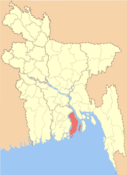 Location of Bhola in Bangladesh | |
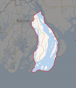
Expandable map of Bhola District | |
| Coordinates: 22.69°N 90.6525°E | |
| Country | |
| Division | Barisal Division |
| Area | |
| • Total | 3,403.48 km2 (1,314.09 sq mi) |
| Population (2011 Census) | |
| • Total | 2,037,201 |
| • Density | 600/km2 (1,600/sq mi) |
| Literacy rate | |
| • Total | 43.2% |
| Time zone | UTC+06:00 (BST) |
| Postal code | 8300 |
| HDI (2018) | 0.586[1] medium · 16th of 21 |
| Website | www.bhola.gov.bd |
History
The previous name of Bhola district is Ashutosh. J. C. Jack stated in his "Bakerganj Gazetier" that the island started creating in 1235 and cultivation in this area started in 1300. In 1500, Portuguese and Mog pirates established their bases in this island. The Arakan and Mog pirates established their bases in the southern part of Shahbajpur also.
Shahbajpur was a part of Bakerganj district till 1822. At the beginning of 19th century, it became difficult to connect to the southern Shahjadpur from the district headquarter due to the expansion of Meghna River. Government then decided to include south Shahbajpur and Hatia in Noakhali District. Bhola was included in Noakhali till 1869. In 1869, it was included in Barisal District as a sub-division. In 1876, the administrative headquarter was moved from Daulatkhan to Bhola. In 1984, it was established as a district.[4]
Etymology
The canal situated in the Bhola Sadar was very wide in ancient times. The canal was known as Betua river. People used boat to cross the river. There was a very old boatman who used to cross the river daily. His name was Bhola Gazi Patni. The name of the district is derived from the name of this famous boatman, Bhola Gazi. The other sub-districts of this districts are also named according to the names of famous persons as well.[5]
Geography
Bhola is a delta island. There are two rivers in this district which are Meghna and Tetulia. Meghna is in east and north side of the district and Tetulia is in the west side. Bay of Bengal is in the south of Bhola district.
Administration
There are five municipalities, 7 sub-districts, 9 thanas, 66 unions and 473 villages in this district.[6]
Subdistricts
Bhola district comprises the following upazilas:[7]
| Name of Sub-district | union | area (km2) | population |
|---|---|---|---|
| Bhola Sadar Upazila | 13 | 413.16 | 408097 |
| Daulatkhan Upazila | 9 | 316.99 | 173253 |
| Burhanuddin Upazila | 9 | 284.67 | 244137 |
| Tazumuddin Upazila | 5 | 512.92 | 120189 |
| Lalmohan Upazila | 9 | 396.24 | 276547 |
| Char Fasson Upazila | 14 | 1440.04 | 413593 |
| Manpura Upazila | 3 | 373.19 | 67034 |
Demographics
Total population of Bhola district is 2,037,201. Total male population is 1,042,435 and female is 994,766. Density of population is 500 people per square kilometres. 95.73% of the total population are Muslims, 4.24% are hindus, 0.006% are buddhists, 0.005% are Christians and the remaining are other religious beliefs. There are 2391 mosques, 130 hindu temple and 1 church in this district.[8]
Economy
80% of the total people living here are fisherman. Main source of income of this district are: Agriculture 63.64%, non-agricultural labourer 4.95%, industry 0.50%, commerce 12.67%, transport and communication 2.47%, service 5.74%, construction 1.55%, religious service 0.35%, rent and remittance 0.44% and others 7.69%. There is no major industry in this district due to its geographical location. In recent times, small factories like shoe, plastics, wax, tar etc. have been established here.[9]
Education
Literacy rate of Bhola district is 47% (grossly inaccurate as of 2016). Literacy rate among male population is 38.28% and female population is 34.25%. There are 3 government and 34 non-government colleges, 6 government and 169 non-government high schools, 77 junior high schools, one PT I, one VTI, 9 technical schools, 922 government primary schools and 32 community primary schools in Bhola. There are 103 Kowmi madrasa, 460 ebtedai madrasa, 185 dakhil madrasa, 25 alim madrasa, 28 fazil madrasa and 4 kamil madrasa in Bhola.[10] Notable schools and colleges are:
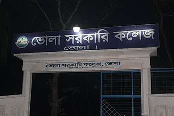
- Bhola Government College
- Bhola Girls High School
- Bhola Govt. High School
- Govt. Fazilatunnesa Women's College
- Shahabajpur Govt. College
- Charfassion Govt. College.
- Bhola Govt. Technical School & College
- Bhola Darul Hadis Kamil - Mastars Madrasah (1913)
Health
There are one modern government hospital, 6 government health complex, 1 Tuberculosis clinic, 1 mother and child care, 1 diabetic hospital, 276 satellite clinic and 2 government child care in this district.[11]
Transportation
There is no railways and airport in this district and no direct connection to the capital by road. Waterways are the main medium of transportation. Launch, steamer and sheep are used for transportation. Bhola is 195 km away from Dhaka by waterways and 247 km away by road. Total area of rivers is 1133.46 sq. km. Total length of road is 3893.65 km, concrete road is 3001.8 km and dirt road is 899.85 km.
Major launch services are M.V Greenline 1&2 M.V Bhola,Tasrif, Shompod, Srinagar, Karnaphuli, Balia and Lali. The condition of internal travels is very good. Road transportation is available between the sub-districts. Sea-truck is used for travelling Monpura sub-district.[12]
Member of the 11th parliament[13]
| Member | Seat | Party |
|---|---|---|
| Tofail Ahmed | Bhola-1 | Bangladesh Awami League |
| Ali Azam | Bhola-2 | Bangladesh Awami League |
| Nurunnabi Chowdhury | Bhola-3 | Bangladesh Awami League |
| Abdullah Al Islam Jakob | Bhola-4 | Bangladesh Awami League |
Notable places[14]
- Monpura char
- Char Kukri mukri
- Deuli
- Dhal Char
- Manpura landing station
- Taruia Seabeach
- Sojib wazed Joy digital Park
- Sahabazpur gas Khetro
- Watch Tower (Jakob Tower)
- Nizam-Hasina foundation Mosque
- Tulatuli
Notable people[15]
- Mostafa Kamal (Bir Sreshtho), freedom fighter in 1971
- Abdullah Al Islam Jakob [politician]
- Mosharef Hossain Shahjahan
- Major Hafizuddin Ahmed (Bir Bikrom), politician
- Comrade Nalini Das, leader of British opposition movement
- Andaliv Rahman Partho, politician
- Tofail Ahmmed [politician]
- Ulama Mawlana Naseer Ahmad Khan, 1925, Bhola Islamia Senior Madrasah
Notes
| Wikimedia Commons has media related to Bhola District. |
- "Sub-national HDI - Area Database - Global Data Lab". hdi.globaldatalab.org. Retrieved 2020-03-18.
- Md Sakhaowat Hossain (2012). "Bhola District". In Sirajul Islam and Ahmed A. Jamal (ed.). Banglapedia: National Encyclopedia of Bangladesh (Second ed.). Asiatic Society of Bangladesh.
- http://bhola.amardesh.com, Retrieved on 24-02-2011.
- "Background of district". Bangladesh national portal.
- "Background of district". Bangladesh national portal.
- "Bhola district". Banglapedia.
- "Bhola district". Banglapedia.
- "Bhola district". Banglapedia.
- "Business in District". Bangladesh national portal.
- "District at a glance". Bangladesh national portal.
- "District at a glance". Bangladesh national portal.
- "Transportation of district". Bangladesh national portal.
- "List of members of the 11th parliament". National parliament of Bangladesh.
- "Tourist spots". Bangladesh national portal.
- "Famous persons". Bangladesh national portal.
| Upazila/Thana: |
| |
|---|---|---|
