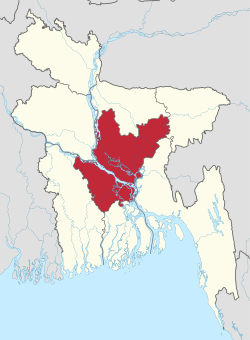
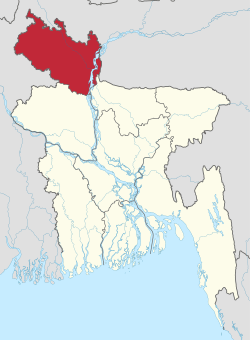
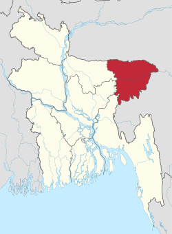
Dhaka Division
Dhaka Division (Bengali: ঢাকা বিভাগ, Ḑhaka Bibhag) is an administrative division within Bangladesh.[2] The capital and largest city is Dhaka. The Division as constituted prior to 2015 covered an area of 31,051 km2,[2] and had a population of 47,424,418 at the 2011 Census. However, following the separation of the new Mymensingh Division in 2015, the area has been reduced to 20,508.8 km2 with a population at the 2011 Census of 36,433,505.
Dhaka Division ঢাকা বিভাগ | |
|---|---|
 | |
| Coordinates: 24°10′N 90°25′E | |
| Country | |
| Capital | Dhaka |
| Area | |
| • Total | 20,508.8 km2 (7,918.5 sq mi) |
| (as reduced in 2015 by new Mymensingh Division) | |
| Population (2011 Census - as reduced by creation of new division) | |
| • Total | 36,433,505 |
| • Density | 1,800/km2 (4,600/sq mi) |
| Time zone | UTC+6 (BST) |
| ISO 3166 code | BD-C |
| HDI (2017) | 0.620[1] medium |
| Notable cricket teams | Dhaka Gladiators(Dissolved) Dhaka Dynamites Dhaka Metropolis Dhaka Division |
| Website | dhakadiv |
Dhaka Division is bounded by Mymensingh Division to the north, Barisal Division to the south, Chittagong Division to the east and south-east, Sylhet Division to the north-east, Rangpur Division to the north-west, and Rajshahi Division to the west and Khulna Divisions to the south-west.
Administrative divisions
Dhaka Division consisted before 2015 of four city corporations, 17 districts, 123 upazilas and 1,248 union parishads. However, four of the most northerly of the 17 districts were removed in 2015 to create the new Mymensingh Division, and another five districts (those situated to the south of the Ganges/Padma River) are in the process of being removed to create a new Faridpur Division.
| Name | Capital | Area (km2) | Area (sq mi) | Population 1991 Census | Population 2001 Census | Population 2011 Census |
|---|---|---|---|---|---|---|
| Dhaka District | Dhaka | 1,463.60 | 565.10 | 5,839,642 | 8,511,228 | 12,043,977 |
| Gazipur District | Ghazipur | 1,806.36 | 697.44 | 1,621,562 | 2,031,891 | 3,403,912 |
| Kishoreganj District | Kishoreganj | 2,688.59 | 1,038.07 | 2,306,087 | 2,594,954 | 2,911,907 |
| Manikganj District | Manikganj | 1,383.66 | 534.23 | 1,175,909 | 1,285,080 | 1,392,867 |
| Munshiganj District | Munshiganj | 1,004.29 | 387.76 | 1,188,387 | 1,293,972 | 1,445,660 |
| Narayanganj District | Narayanganj | 684.37 | 264.24 | 1,754,804 | 2,173,948 | 2,948,217 |
| Narsingdi District | Narsingdi | 1,150.14 | 444.07 | 1,652,123 | 1,895,984 | 2,224,944 |
| Tangail District | Tangail | 3,414.35 | 1,318.29 | 3,002,428 | 3,290,696 | 3,750,781 |
| North of the Padma (Ganges) (proposed reduced Dhaka Division) | 13,595.36 | 5,249.20 | 18,540,942 | 23,077,753 | 29,976,567 | |
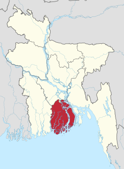
| Faridpur District | Faridpur | 2,052.68 | 792.54 | 1,505,686 | 1,756,470 | 1,912,969 |
| Gopalganj District | Gopalganj | 1,468.74 | 567.08 | 1,060,791 | 1,165,273 | 1,172,415 |
| Madaripur District | Madaripur | 1,125.69 | 434.63 | 1,069,176 | 1,146,349 | 1,165,952 |
| Rajbari District | Rajbari | 1,092.28 | 421.73 | 835,173 | 951,906 | 1,049,778 |
| Shariatpur District | Shariatpur | 1,174.05 | 453.30 | 953,021 | 1,082,300 | 1,155,824 |
| South of the Padma (Ganges) (proposed new Faridpur Division) | 6,913.44 | 2,669.29 | 5,423,847 | 6,102,298 | 6,456,938 | |
| Total Districts * | 13 | 20,508.80 | 7,918.49 | 23,964,789 | 29,180,051 | 36,433,505 |
Note: * revised area and its population after excluding the districts transferred to the new Mymensingh Division. Aah Towfiq Public Service
Association
- ওয়েলফশন মানবকল্যাণ সংঘ[3] (EN- Welftion Human Welfare Association)
Sources
| Wikivoyage has a travel guide for Dhaka Division. |
Census figures for 1991, 2001 and 2011 are from Bangladesh Bureau of Statistics, Population Census Wing. The 2011 Census figures are based on preliminary results.
References
- "Sub-national HDI - Area Database - Global Data Lab". hdi.globaldatalab.org. Retrieved 2018-09-13.
- Sajahan Miah (2012). "Dhaka Division". In Sirajul Islam and Ahmed A. Jamal (ed.). Banglapedia: National Encyclopedia of Bangladesh (Second ed.). Asiatic Society of Bangladesh.
- "ওয়েলফশন এর করোনা কর্মসূচি সমাপ্ত ও ঈদ উপহার সামগ্রী বিতরণ। - PBN24". pbn24.com. Retrieved 2020-05-26.
Places adjacent to Dhaka Division | ||||||||||
|---|---|---|---|---|---|---|---|---|---|---|
| ||||||||||


| Barisal Division |
|  |
|---|---|---|
| Chittagong Division | ||
| Dhaka Division | ||
| Khulna Division | ||
| Mymensingh Division | ||
| Rajshahi Division | ||
| Rangpur Division | ||
| Sylhet Division | ||