Kushtia District
Kushtia (Bengali: কুষ্টিয়া জেলা, pronunciation: kuʃʈia) is a district in the Khulna administrative division of western Bangladesh. Kushtia has existed as a separate district since the partition of India.[2] Prior to that, Kushtia was a part of Nadia District under Bengal Province of British India. Kushtia was the ancestral land of many famous people including Rabindranath Tagore, Lalon Fakir, Mir Mosharraf Hossain etc.
Kushtia কুষ্টিয়া | |
|---|---|
    .jpg) .jpg) .jpg)  from top: Hardinge bridge, Tagore kuthibari, Tomb of Lalon, Kushtia municipality, BRB Cable tower, Lovely tower, Porimol Tower, Selima medical college hospital | |
 Location of Kushtia District in Bangladesh | |
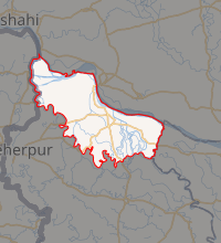
Expandable map of Kushtia District | |
| Coordinates: 23°55′11″N 89°13′12″E | |
| Country | |
| Division | Khulna Division |
| Headquarters | Kushtia |
| Area | |
| • District | 1,608.80 km2 (621.16 sq mi) |
| Population (2020) | |
| • District | 2,366,811 |
| • Density | 1,500/km2 (3,800/sq mi) |
| • Urban | 850,000 |
| Demographics | |
| • Literacy | 92% (excluding 0–6 population) |
| Time zone | UTC+06:00 (BST) |
| Postal code | 7000 |
| HDI (2018) | 0.672[1] medium · 2nd of 21 |
| Website | http://www.kushtia.gov.bd/ |
History
The Shahi Mosque in Kushtia bears the sign of rich cultural heritage of the region from the Mughal period. Kushtia is the birthplace of many historical figures including Mir Mosharraf Hossain (1847–1912), Bagha Jatin (1879–1915) and Lalon Fakir (1774–1890). Nobel laureate poet Rabindranath Tagore lived his early life at Shelaidaha.
However, during the British rule Kushtia was not a separate district – it was a part of the Nadia district (now in West Bengal). A municipality was established in Kushtia in 1869.
Kushtia is a medieval township. A river port was developed in the district during the reign of Emperor Shahjahan. Although the British East India Company made extensive use of the port, it was not until indigo planters and traders settled there that the township began to grow. A railway connection was made in 1860 with Calcutta (now Kolkata), capital of British India, which made the town an alluring location for mills and factories, including the Jagneshwar Engineering Works (1896), Renwick and Company (1904), and the Mohini Mills (1919).
In 1860, the Indigo revolt spread throughout the Bengal province. Shalghar Madhua in Kushtia district was one of the forerunners in this movement.[2] It inspired all indigo farmers in Kushtia to refrain from paying government taxes.[2] Subsequently, with the publication of the Indigo Commission Report, an act was passed prohibiting coercion of cultivators for indigo cultivation and the measure led to the end of the movement.[3]

During the Partition of India in 1947, three sub-divisions of Nadia district i.e.Kushtia, Chuadanga and Meherpur were detached and amalgated into new District of Kushtia in the then East Pakistan. The Bangladesh government later in 1984 divided Kushtia and Chuadanga and Meherpur became separate districts. The town once again became attractive for development in 1954 with the establishment of the Ganges-Kobadak Irrigation Project (also known as G-K Project) headquarters and a number of government offices. The G-K Project is a large surface-irrigation system, with the first crop under this project grown in 1962–63.[4]
The district of Kushtia had significant contribution to the Bangladesh Liberation War. A 147-member company of the 27th Baluch Regiment of the Pakistan army reached Kushtia on 25 March 1971 from its base at Jessore cantonment. They initially captured the local police station and settled an outpost there, but soon faced considerable resistance from a group of police, ansars, students and local people. By 1 April, the Pakistany army was completely overpowered and the Mukti Bahini took control of Kushtia.[5] Later on 17 April 1971 the Bangladesh Government in-exile formally announced Proclamation of Independence at Baidyanathtala.[6] Subsequently, battles between the Pakistan army and the rebels occurred at many places of the district including Bangshitala of Kumarkhali Upazila,[7] and Daulatpur Upazila.,[8]
After the independence of Bangladesh several different development projects were undertaken in the district of Kushtia. On 22 November 1979 the foundation stone of The Islamic University was laid at Shantidanga – Dulalpur under the districts of Kustia and Jhenidah. However, In 1982 the University was shifted to Gazipur and admission of students began in the session of 1985–86. Later, on 10 January 1990, the University shifted back to its original site at Shantidanga Dulalpur. In 1984, two subdivisions of Kushtia: Chuadanga[9] and Meherpur[10] were named separate districts.
Geography

Kushtia District has an area of 1608.80 square kilometres and is bounded by Rajshahi, Natore, Pabna districts to the North, by Chuadanga, Jhenaidah districts to the South, by Rajbari District to the East, and by West Bengal and Meherpur District to the West.
Ganges, Gôŗai-Modhumoti, Mathabhanga, Kaligônga, and Kumar are the main rivers flowing through the district. The average high temperature is 37.8 °C and the average low is 9.2 °C. Annual rainfall averages 1,467 millimetres.
Administrative divisions
Kushtia was created as a district in 1947 with the partitioning of India. Initially, Kushtia consisted of the Kushtia, Chuadanga and Meherpur subdivisions. Each of these subdivisions was later converted to a separate district for ease of management. The Upazilas are:[2]
Demographics
According to 2011 Bangladesh census, Kushtia District had a population of 1,943,868. Males constituted 50.01% of the population and females 49.99. Muslims formed 97.02% of the population, Hindus 2.92%, Christians 0.01% and others 0.04%. Kushtia had a literacy rate of 46.33% for the population 7 years and above.[11]
In 2001, Kushtia District has a population of 1,740,155, of which 50.86% are male and 49.14% female. In terms of religion, 95.72% dwellers of Kushtia are Muslims, 4.22% follow Hinduism and other religions make up 0.06%. Religious institutions are mosques 3587, temples 185, churches 32.[2]
Tourism
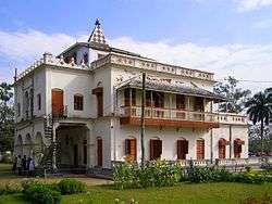
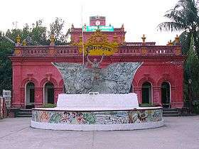
The Shilaidah Kuthibari is an ancestral mansion of the erstwhile Tagore Zamindari.The Kuthibari, located at Shilaidaha in Kumarkhali Upazila of the Kushtia district, is only 20 km from Kushtia town. Rabindaranath Tagore lived here for part of his life, and wrote many memorable poems there. The Kuthibari is now a museum, and is cared for by the Archaeological Department of Bangladesh.
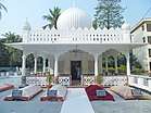
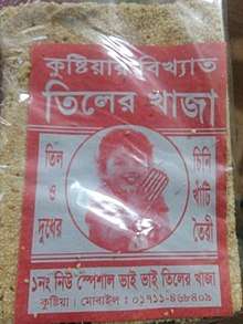
The shrine of Lalon Fakir, the founder of the Baoul faith is located at Cheouria, about 2 km from the Kushtia railway station. You will have Famous Tiler Khaja [12] Factory at just beside the Milpara Rail Gate in Kushtia Town.
Economy
Historically, the region had fertile soil but during the British rule, Indigo used to be cultivated in the region, that's why now the region has poor soil. There is a large industry surrounding Jute. Which is where the name Kushtia comes from since the local name for Jute is Kushti (Bengali: কুষ্টি Pronunciation: Kuṣṭi). There are also numerous rice mills in the area. The economy of Kushtia is mainly dependent on both agriculture and industries.
Media
Numerous Bengali daily and weekly newspapers are published from Kushtia. There's also a Bengali TV channel broadcast in the region.
References
- "Sub-national HDI - Area Database - Global Data Lab". hdi.globaldatalab.org. Retrieved 18 March 2020.
- Nehal, SM Rakib (2012). "Kushtia District". In Islam, Sirajul; Jamal, Ahmed A. (eds.). Banglapedia: National Encyclopedia of Bangladesh (Second ed.). Asiatic Society of Bangladesh.
- Choudhury, Nurul Hossain (2012). "Indigo Resistance Movement". In Islam, Sirajul; Jamal, Ahmed A. (eds.). Banglapedia: National Encyclopedia of Bangladesh (Second ed.). Asiatic Society of Bangladesh.
- Chowdhury, Masud Hasan; Murshed, Sanzida (2012). "Ganges-Kobadak Irrigation Project". In Islam, Sirajul; Jamal, Ahmed A. (eds.). Banglapedia: National Encyclopedia of Bangladesh (Second ed.). Asiatic Society of Bangladesh.
- Coggins, Dan (19 April 1971). "The Battle of Kushtia". Time Inc. Retrieved 31 March 2008.
- Miah, Sajahan (2012). "Proclamation of Independence". In Islam, Sirajul; Jamal, Ahmed A. (eds.). Banglapedia: National Encyclopedia of Bangladesh (Second ed.). Asiatic Society of Bangladesh.
- Tipu, Shiek Md Badrul Alam (2012). "Kumarkhali Upazila". In Islam, Sirajul; Jamal, Ahmed A. (eds.). Banglapedia: National Encyclopedia of Bangladesh (Second ed.). Asiatic Society of Bangladesh.
- Reza, Md. Salim (2012). "Daulatpur Upazila (Kushtia District)". In Islam, Sirajul; Jamal, Ahmed A. (eds.). Banglapedia: National Encyclopedia of Bangladesh (Second ed.). Asiatic Society of Bangladesh.
- Ahmed, Rajib (2012). "Chuadanga District". In Islam, Sirajul; Jamal, Ahmed A. (eds.). Banglapedia: National Encyclopedia of Bangladesh (Second ed.). Asiatic Society of Bangladesh.
- Farooque, Md. Abu Hasan (2012). "Meherpur District". In Islam, Sirajul; Jamal, Ahmed A. (eds.). Banglapedia: National Encyclopedia of Bangladesh (Second ed.). Asiatic Society of Bangladesh.
- "Bangladesh Population and Housing Census 2011: Zila Report – Kushtia" (PDF). Table P01 : Household and Population by Sex and Residence, Table P05 : Population by Religion, Age group and Residence, Table P09 : Literacy of Population 7 Years & Above by Religion, Sex and Residence. Bangladesh Bureau of Statistics (BBS), Ministry of Planning, Government of the People’s Republic of Bangladesh. Retrieved 9 December 2018.
- Khaja: Kushtia's mouth-watering sweet. The Daily Star. Retrieved on 2020-04-25.
External links
| Wikimedia Commons has media related to Kushtia District. |
| Upazila/Thana: | ||
|---|---|---|
