Habiganj District
Habiganj (Bengali: হবিগঞ্জ, Sylheti: ꠢꠛꠤꠉꠂꠘ꠆ꠎ), formerly known as Habibganj, which was named after its founder Syed Habib Ullah of Taraf Kingdom, is a district of the Sylhet Division in the north-eastern part of Bangladesh. Between the thirteenth and early seventeenth centuries, Habiganj was part of the state of Nasirabad, now called Mymensingh. At present, it is a district of Sylhet Division.[2][3]
Habiganj হবিগঞ্জ ꠢꠛꠤꠉꠂꠘ꠆ꠎ | |
|---|---|
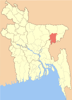 Location of Habiganj District in Bangladesh | |

Expandable map of Habiganj District | |
| Country | |
| Division | Sylhet Division |
| Area | |
| • Total | 2,636.59 km2 (1,017.99 sq mi) |
| Demonym(s) | Habiganji, Hobigonji, Hobigoinji |
| Time zone | UTC+06:00 (BST) |
| Postal code | 3330-3374 |
| HDI (2018) | 0.535[1] low · 21st of 21 |
| Website | www |
With the passage of time, Habibganj turned into Habiganj. During the British Raj, Habiganj was established as a Thana (police precinct) in 1790, under Dhaka district (1779–1793). Until 1896, Habiganj's administrative centre was in Court Andar, Laskarpur. On 12 September 1874 it came under Sylhet district (part of Assam). Habiganj was declared as subdivision in 1867. On 7 April 1893, according to Notification #273 of Assam Provincial Government, Habiganj Thana (Administrative unit) was established. Habiganj was rejoined with East-Bengal (now Bangladesh) in 1911. Then the Office of the Circle Officer (Development) was established in 1960. On 1 March 1984 Habiganj was established as a District.[4] Md. Kamrul Hasan is the Deputy Commissioner.[5]
At present Habiganj consists of 9 upazilas, 6 municipalities, 54 wards, 78 union parishads, 124 mahallas, 1241 mouzas and 2076 villages.[6]
History
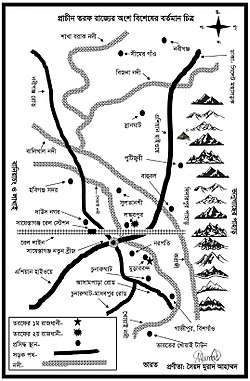
Chaklapunji
All the reported prehistoric records of Bangladesh are associated with the Lalmai hills and the higher areas of Sylhet, Habiganj, and Chittagong and Madhupur tract. The prehistoric site of Chaklapunji tea garden, near Chandirmazar of Chunarughat. Habiganj has also revealed a significant number of prehistoric tools from the bed of a small ephemeral stream (water remains here only for a few hours after rainfall) known as Balu nadi (river). Angularity and freshness of the fossil wood artifacts suggest that they did not come from a great distance and probably came from nearby hillocks. Typologically, technologically, and morphometrically, the artifacts are more or less the same as those found in the Lalmai area. The Fossil wood assemblages of Lalmai and Chaklapunji can be classified into two groups:
- Pre-neolithic assemblages without polished tools (hand axes, cleavers, scrapers, chopping tools, points etc.);
- Neolithic assemblages (hand adzes, polished Celts, awls etc.).
Battle of Jilkua 1581 A.D
From the time of the conquest of Sylhet and Taraf by Muslim s in 1302-22 A .D ., to the time o f the annexation of the territory of Sylhet to the Mughal Empire in 1612 A.D . little is known with any certainty about this ruling power in the district, excepting that Amar Manikya (1577–86) king of Tripura raj while digging a tank in his capital called upon Syed Musa, son o f Syed Shah Mikail to contribute laborers. Syed Musa refused to accept this subordination and Tripurah claim. Tripura King attacked Taraf and a battle took place at Jilkua village to the south of Chunarghat in which Syed Musa and his son Bairam were taken prisoner in 1581 A.D . Syed Musa suffered imprisonment in Tripura capital but Syed Bairam was set free. By the middle of the 15th century, when all the divisions of the Laur territory were united under the headship of Baniachung house (now of Muslim faith) it seems the Muslim area of Taraf passed under the control of Baniachung, which now became very powerful to include in its territory, the whole of present Sunamganj and Habiganj subdivisions.
Battle of Bara Bhuiyans and Mughal
In Baniachang a battle occurred between Anwar Khan (the Zamindar of Sylhet) and Hussain Khan (Baro-Bhuyans of Baniachang) with the Mughal army in the 17th century, which can be found in the Bahrastan-i-Gayebi.
Fort of Putijuri
Khwaja Usman fled Bukai Nagar Fort and established a shelter at Putijuri on the foot of the Giripal. He also established a fort at Putijuri, which was extremely important for defense. The Mughal army took the advantage when Khwaja Osman's brother was absent from the fort, and finally defeated the Khwaja Osman's army at the village called Dhalamvapur, Maulvi Bazar District.
Indian National Congress
In the second session of the Congress held in Calcutta in 1886, the Indian National Congress was able to attract representatives from Habiganj District.
Liberation War of 1971
Habiganj is the historical place where the Mukti Bahini started their first guerrilla movement against oppression of Pakistani Army.
War at Teliapara Tea Garden
On 4 April 1971, during Bangladesh Liberation War the senior army officers assembled at the headquarters of 2nd East Bengal at Teliapara, a semi hilly area covered by tea gardens where General MAG Osmani, Lieutenant Colonel Abdur Rob, Lieutenant Colonel Salahuddin Mohammad Reja, Major Kazi Nuruzzaman, Major Khaled Mosharraf, Major Nurul Islam, Major Shafat Jamil, Major Mainul Hossain Chowdhury, and others were present.
At this meeting four senior commanders were entrusted with the responsibility of operational areas. Sylhet-Brahmanbaria area was placed under the command of Major Shafiullah, Comilla-Noakhali area was given to Major Khaled Mosharraf while Chittagong-Chittagong Hill Tracts was given to Major Ziaur Rahman and Kushtia-Jessore area was placed under command of Major Abu Osman Chowdhury. In the meeting the organization concept of the freedom fighter forces and the command structure were chalked out under the command of General MAG Osmani.[7]
War at Ajmiriganj
During the War of Liberation in 1971 an 18 hours direct encounter between the freedom-fighters and the Pakistani-army was held on 16 November 1971, in which freedom-fighter Jagatyoti and 11 villagers were killed by the Pakistani-army.[8]
Demography
As per district administration report[9] the total population is 2,089,001 of 926,531 male and 904,022 female (50.6% male and 49.4% female). Category by religion 80.23% Muslim, 19.12% Hindu, 0.05% Buddhist, 0.13% Christian and 0.47% others. Life Expectancy: 56 years both male and female. Age Breakdown: 42% (under 15); 26% (15-29); 16% (30-44); 9% (45-59); 5% (60 and 60+); and 2% (not known). Birth Rate: 33.0 per 1,000. Death Rate: 11.4 per 1,000. Population growth rate: 21.6 per 1,000. Infant Mortality Rate: 98.0 per 1,000 live births.
Over 98% of the population are Bengalis while the remainder are Biharis, Khasias, Meiteis and Tripuris.
The Twipra or Tipperah are the original inhabitants of the state of Tripura. The Royal family of the Debbarma ruled the state of Tripura for more than 2,000 years till the kingdom was joined with the India in 1949.
The original Meitei homeland is Manipur, once a sovereign state and now the north-eastern state of India. In the early days, Manipur had different names such as Kangleipak, Kangkleipang, Kanglei, Meitrabak, and Mekhali. During the reign of Maharaj Garibniwaz (1709–1748), Meiteis arrived here. The Khasia is a Mongolite ethnic group. The Khasi descended to the Khasia hills and Jaintia hills from Cherrapunji and Shilong regions. They migrated to Habiganj from Assam where they arrived some 500 years ago.
Upazila
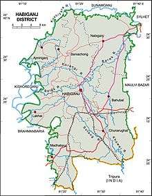
Habiganj District comprises nine Upazilas (sub-districts);
- Ajmiriganj
- Baniachang
- Bahubal
- Chunarughat
- Habiganj Sadar
- Lakhai
- Madhabpur
- Nabiganj
- Sayestaganj
Geography
Habiganj is located at 24.3750°N 91.4167°E. Its area is 2,636.58 km² and bounded by Sunamganj District to the north, Tripura of India and Maulvibazar District to the east, Balaganj Upazila of Sylhet to the north-east, Brahmanbaria and Kishoreganj districts to the west.[6]
This part of Bangladesh is characterized by alluvial plains which are dissected by various connecting rivers as well as streams, lakes; and it is vulnerable to both flood and drought. The land is devoted mainly to agriculture due to its fertile alluvial soils.
Land
Cultivated agricultural land: 1,54,953 hectare (60.22% of the total agricultural land). Forestland 95 11,644 hectare (4.53% of the total land). For crops 51.6% single-crop, 38.7% double-crop and 9.7% triple-crop; fallow 521 hectares. Its rivers include Barak, Bheramahana, Gopala, Kalni, Kalishiri, Khowai, Korangi, Kushiara, Meghna River(lower), Ratna, Shwasanali, shutki, sonai, Korangi, Shutang, Tentulia, Jhingri, Bizna and Yojnal.
Economy
- Tea Gardens: 24 covering total area 15,703.24 hectare.
- Rubber gardens: 3 Rupaichhara-Bahubal (1981). Half of this garden is situated in Habiganj and the rests are in Shreemangal, total area 2,000 acres (8.1 km2). Shahjibazar-Chunarughat(1978) area 2,004 acres (8.11 km2), Shatgaon Rubber garden (1971) area 200 acres (0.81 km2).
Rashidpur gas field (1960), Bibiana gas field (1998) and Habiganj gas field (1963). The approximate stock of these gas fields is 5.5 Trillion Cubic Feet. Habiganj gas field lies in Madhabpur Upazila. This field was also discovered by Pakistan Shell Oil Company in 1963. The structure measures 12x5 square km with a vertical closure of 300 m which has a roughly sub-meridian axis tilted slightly eastward at the northern end. Total recoverable gas reserve of this field re-estimated by Hydrocarbon Unit is 3,852.30 billion cubic feet (1.09085×10¹¹ m3). Commercial gas production from this field was commenced in 1968 and till 31 August 2006 total 1,364.474 billion cubic feet (3.86376×10¹⁰ m3) or 35.42 percent of reserves has been recovered.
Education
There are total 16 Colleges of which 1 (Honors) College, 3 Government colleges, 1 Polytechnic institute; 13 (further education) Colleges, 6 (government) and 99 (non-government) High Schools; 14 Junior Schools; 732 (government) and 711 (non-government) Primary Schools; 96 Madrasah; and 6 Satellite (temporary) Schools in this district. [9]
Literature and culture
Habigang is famous for folk Literature: Mahuya Sundari and Dhupar Path.
Local newspapers: Daily Habiganj Express, Daily Pravakar, Pratidener Bani, weekly Swadhikar, Swadeshbarta, Drishtikon, Daily Khowai, Habiganj Samachar, Janatar Dalil, Parikrama, fortnightly Prayas, The Daily Habiganjer Ayna and Mritika.
Defunct local newspapers: monthly Moitri (1909), weekly Projapati (1909), Sree Sree Sonar Gauranga (1329 BS), Palli Bani (1940), weekly Shahid (1948), weekly Jagaran (1955), monthly Avijatrik (1966).
Sports
The Habiganj Adhunik Stadium is the largest stadium in Habiganj. The 20,000-capacity venue is used for cricket and football.
Notable people
- Sirajul Hossain Khan, Formar Minister(1985-1990),MP, Journalist and former general secretary, east Pakistan journalist union, leftist politician.
- Bipin Chandra Pal, nationalist leader
- Major General Mohammad Abdur Rab (Bir Uttam), Chief of Staff of Liberation Forces
- Shah Kibria, Former Finance Minister of Bangladesh, d. 2005
- Dewan Farid Gazi, Veteran politician (Awami League) and freedom fighter/activist, Former Minister of Bangladesh
- Major General Chitta Ranjan Dutta- Bir Uttam
- Jagat Joity Das - Bir Bikrom
- Enamul Haque Mostafa Shahid, Veteran politician (Awami League) and freedom fighter/activist, Former Social Welfare Minister of Bangladesh, d. 2016
- Mukhlesur Rahman Chowdhury, former advisor to the President of Bangladesh and minister
- Hemango Biswas, Nationalist Leader, poet and singer
- Syed A. B. Mahmud Hossain, Chief Justice of Bangladesh
- Justice Syed Husain, Chief Justice (since 27 January 2004)
- Mudabbir Hossain Chowdhury Former Inspector General of Police (IGP)
- Sir Fazle Hasan Abed KCMG - Founder and Chairperson, BRAC
- Chowdhury Fazlul Bari — Former Additional DG of RAB, Former Director of Military Intelligence Agency
- Syeda Rizwana Hasan, Environmentalist, Winner Ramon Magsasai Prize(Novel Prize of Asia)
- Amatul Kibria Keya Chowdhury
- Subir Nandi
Archaeological heritage

- Ancient Rajbari (1737–38) at Puranbagh, Baniachang
- Bagala Matar Mandir, Habiganj
- Baniachong village (the biggest village in Asia)
- Bibir Dargah Mosque, Baniachang
- Bithangal Akhra, Baniachang
- Dorga-tila, Mira-tila and Tangee-tila, Nabiganj
- Foltoli-tila and water fountain, Nabiganj
- Jami Mosque, Bahubal
- Kalibari, Habiganj Sadar
- Kuri-tila, Black-stone and an Ancient Rajbari, Dinarpur, Nabiganj
- Mashulia Akhra, Habiganj Sadar
- Mosque of Uchail, built by Mojlishe Amin, habiganj by azaz
- Murarbandar Dargah Sharif, Chunarughat
- Hoojra Khana of Syed Nasir Uddin, Murarbandar Dargah Sharif, Chunarughat.[10]
- Putijuri Jami Mosque, Bahubal
- Ramakrishna Ashram, Habiganj Sadar
- Rashidpur Tea Garden, Bahubal Upazila
- Shagor Dighi, Baniachong
- Shajeerbazar, Chunarughat
- Sham-baoul Akhra and Doulotpur Akhra, Baniachang
- War of Liberation Mass Grave, Nabiganj
- War of Liberation Memorial Monument, Nabiganj
See also
References
| Wikimedia Commons has media related to Habiganj District. |
- "Sub-national HDI - Area Database - Global Data Lab". hdi.globaldatalab.org. Retrieved 2020-03-18.
- Irani, Ayesha A. (5 December 2011). Sacred biography, translation, and conversion ; The Nabīvaṃśa of Saiyad Sultān and the making of Bengali Islam, 1600-present (PhD). University of Pennsylvania. Archived from the original on 2016-09-13. Retrieved 2016-09-03.
- প্রাচীন তরফ রাজ্যের সংক্ষিপ্ত ইতিবৃত্ত. Daily Sylheter Songbad (in Bengali). 17 November 2015.
- এক নজরে হবিগঞ্জ [Habiganj at a glance]. Habiganj District (in Bengali). Bangladesh National Portal.
- জেলা প্রশাসকের প্রোফাইল [DC Profile]. Habiganj District (in Bengali). Bangladesh National Portal.
- Jayanta Sing Roy (2012). "Habiganj District". In Sirajul Islam and Ahmed A. Jamal (ed.). Banglapedia: National Encyclopedia of Bangladesh (Second ed.). Asiatic Society of Bangladesh.
- "Attack on Kalachara". Victory Day Special. The Daily Star. Archived from the original on 2009-11-16. Retrieved 2009-11-16.
- "History of Habiganj". My Habiganj. Archived from the original on 2009-12-14. Retrieved 2009-11-15.
- মুড়ারবন্দ তরফ রাজ্যের প্রথম রাজধানী ও সৈয়দ বংশের উৎসস্থল. Shaistaganj.com. Retrieved 2016-11-08.
| Barisal Division |
|  |
|---|---|---|
| Chittagong Division | ||
| Dhaka Division | ||
| Khulna Division | ||
| Mymensingh Division | ||
| Rajshahi Division | ||
| Rangpur Division | ||
| Sylhet Division | ||
Capital: Habiganj | ||
| Upazilas | ||
| Constituencies | ||
| Attractions and sites | ||
| Rivers | ||
| Educational institutions | ||
| History | ||
| Transport | ||