West Brunswick Township, Schuylkill County, Pennsylvania
West Brunswick Township is a township in Schuylkill County, Pennsylvania, United States. Brunswick Township was formed in 1801 as one of the original townships of Schuylkill County, being named for Brunswick (Braunschweig), Germany. In 1835, Brunswick Township was divided into East and West Brunswick Townships. Among the village names in the township are Molino, Pinedale and Frisbie.
West Brunswick Township, Pennsylvania | |
|---|---|
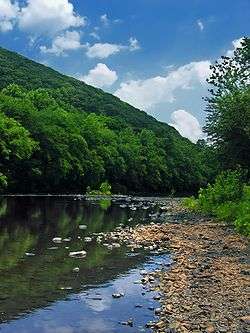 The Schuylkill River in West Brunswick Township | |
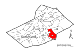 Map of Schuylkill County, Pennsylvania Highlighting West Brunswick Township | |
 Map of Schuylkill County, Pennsylvania | |
| Country | United States |
| State | Pennsylvania |
| County | Schuylkill |
| Settled | 1801 |
| Incorporated | 1835 |
| Area | |
| • Total | 30.59 sq mi (79.22 km2) |
| • Land | 30.43 sq mi (78.82 km2) |
| • Water | 0.15 sq mi (0.40 km2) |
| Population (2010) | |
| • Total | 3,327 |
| • Estimate (2016)[2] | 3,257 |
| • Density | 107.02/sq mi (41.32/km2) |
| Time zone | UTC-5 (Eastern (EST)) |
| • Summer (DST) | UTC-4 (EDT) |
| Area code(s) | 570 |
| FIPS code | 42-107-82632 |
Geography
According to the United States Census Bureau, the township has a total area of 30.5 square miles (79.1 km²), of which, 30.3 square miles (78.6 km²) is land and 0.2 square miles (0.5 km²; 0.66%) is water.
Demographics
| Historical population | |||
|---|---|---|---|
| Census | Pop. | %± | |
| 2010 | 3,327 | — | |
| Est. 2016 | 3,257 | [2] | −2.1% |
| U.S. Decennial Census[3] | |||
At the 2000 census there were 3,428 people, 1,323 households, and 998 families living in the township. The population density was 113.0 people per square mile (43.6/km²). There were 1,402 housing units at an average density of 46.2/sq mi (17.8/km²). The racial makeup of the township was 96.65% White, 0.23% African American, 0.06% Native American, 2.22% Asian, 0.12% from other races, and 0.73% from two or more races. Hispanic or Latino people of any race were 0.26%.[4]
Of the 1,323 households 31.2% had children under the age of 18 living with them, 67.2% were married couples living together, 5.4% had a female householder with no husband present, and 24.5% were non-families. 21.4% of households were one person and 7.7% were one person aged 65 or older. The average household size was 2.54 and the average family size was 2.96.
The age distribution was 22.3% under the age of 18, 6.4% from 18 to 24, 26.9% from 25 to 44, 28.7% from 45 to 64, and 15.7% 65 or older. The median age was 42 years. For every 100 females, there were 99.5 males. For every 100 females age 18 and over, there were 95.5 males.
The median household income was $47,091 and the median family income was $51,292. Males had a median income of $39,886 versus $22,398 for females. The per capita income for the township was $27,436. About 4.7% of families and 5.4% of the population were below the poverty line, including 2.8% of those under age 18 and 9.9% of those age 65 or over.
Recreation
Portions of the Pennsylvania State Game Lands Number 106 and Number 110 which carry the Appalachian National Scenic Trail are located along the southern border of the township.[5][6][7]
References
- "2016 U.S. Gazetteer Files". United States Census Bureau. Retrieved Aug 14, 2017.
- "Population and Housing Unit Estimates". Retrieved June 9, 2017.
- "Census of Population and Housing". Census.gov. Retrieved June 4, 2016.
- "U.S. Census website". United States Census Bureau. Retrieved 2008-01-31.
- https://viewer.nationalmap.gov/advanced-viewer/ The National Map, retrieved 27 October 2018
- Pennsylvania State Game Lands Number 106, retrieved 27 October 2018
- Pennsylvania State Game Lands Number 110, retrieved 29 October 2018