Kuril Islands
The Kuril Islands or Kurile Islands (/ˈkʊərɪl, ˈkjʊərɪl, kjʊˈriːl/; Russian: Кури́льские острова́, tr. Kurilskiye ostrova, IPA: [kʊˈrʲilʲskʲɪjə ɐstrɐˈva] or Russian: островá Тисима, tr. ostrova Tisima; Japanese: Kuriru rettō (クリル列島, "Kuril Islands") or Chishima rettō (千島列島, "Chishima Islands")) is a volcanic archipelago in Russia's Sakhalin Oblast that stretches approximately 1,300 km (810 mi) northeast from Hokkaido, Japan to Kamchatka, Russia, separating the Sea of Okhotsk from the north Pacific Ocean. There are 56 islands and many minor rocks. It consists of the Greater Kuril Chain and the Lesser Kuril Chain.[1] The total land area is 10,503.2 square kilometres (4,055.3 sq mi),[2] and the total population is 19,434.[3]
| Disputed islands Native name: Курильские острова 千島列島 | |
|---|---|
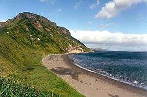 Kuril Island Coastline | |
| Geography | |
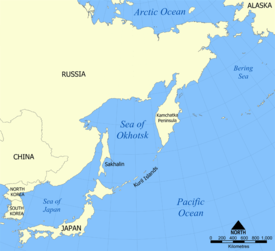 Location of the Kuril Islands in the Western Pacific between Japan and the Kamchatka Peninsula of Russia | |
| Location | Pacific Ocean |
| Coordinates | 46°30′N 151°30′E |
| Total islands | 56 |
| Area | 10,503.2 km2 (2,595,400 acres; 4,055.3 sq mi) |
| Length | 1,150 km (715 miles) |
| Highest point |
|
| Administered by | |
| Federal subject | Sakhalin Oblast |
| Districts | Severo-Kurilsky, Kurilsky, Yuzhno-Kurilsky |
| Claimed by | |
(partial claim, southernmost islands) | |
| Prefecture | Hokkaido |
| Subprefecture | Nemuro |
| Demographics | |
| Population | 19,434 (as of 2010) |
All the islands are under Russian administration. Japan claims the four southernmost islands, including two of the three largest ones (Iturup and Kunashir), as part of its territory as well as Shikotan and the Habomai islets, which has led to the ongoing Kuril Islands dispute. The disputed islands are known in Japan as the country's "Northern Territories".[4] In 2018, Russo-Japanese talks on reunification of islands with Japan resumed.[5]
Etymology
The name Kuril originates from the autonym of the aboriginal Ainu, the islands' original inhabitants: kur, meaning "man". It may also be related to names for other islands that have traditionally been inhabited by the Ainu people, such as Kuyi or Kuye for Sakhalin and Kai for Hokkaidō. In Japanese, the Kuril Islands are known as the Chishima Islands (Kanji: 千島列島 Chishima Rettō pronounced [tɕiɕima ɾeꜜttoː], literally, Thousand Islands Archipelago), also known as the Kuriru Islands (Katakana: クリル列島 Kuriru Rettō [kɯɾiɾɯ ɾeꜜttoː], literally, Kuril Archipelago). Once the Russians reached the islands in the 18th century they found a pseudo-etymology from Russian kurit' (курить – "to smoke") due to the continual fumes and steam above the islands from volcanoes.
Geography and climate
The Kuril Islands form part of the ring of tectonic instability encircling the Pacific Ocean referred to as the Ring of Fire. The islands themselves are summits of stratovolcanoes that are a direct result of the subduction of the Pacific Plate under the Okhotsk Plate, which forms the Kuril Trench some 200 kilometres (120 mi) east of the islands. The chain has around 100 volcanoes, some 40 of which are active, and many hot springs and fumaroles. There is frequent seismic activity, including a magnitude 8.5 earthquake in 1963 and one of magnitude 8.3 recorded on November 15, 2006, which resulted in tsunami waves up to 1.5 metres (5 ft) reaching the California coast.[6] Raikoke Island, near the centre of the archipelago, has an active volcano which erupted again in June 2019, with emissions reaching 13,000 m.
The climate on the islands is generally severe, with long, cold, stormy winters and short and notoriously foggy summers. The average annual precipitation is 40 to 50 inches (1,020 to 1,270 mm), a large portion of which falls as snow. The Köppen climate classification of most of the Kurils is subarctic (Dfc), although Kunashir is humid continental (Dfb). However, the Kuril Islands’ climate resembles the subpolar oceanic climate of southwest Alaska much more than the hypercontinental climate of Manchuria and interior Siberia, as precipitation is heavy and permafrost completely absent. It is characterized by mild summers with only 1 to 3 months above 10 °C or 50 °F and cold, snowy, extremely windy winters below −3 °C or 26.6 °F, although usually above −10 °C or 14 °F.
The chain ranges from temperate to sub-Arctic climate types, and the vegetative cover consequently ranges from tundra in the north to dense spruce and larch forests on the larger southern islands. The highest elevations on the islands are Alaid volcano (highest point: 2,339 m or 7,674 ft) on Atlasov Island at the northern end of the chain and Tyatya volcano (1,819 m or 5,968 ft) on Kunashir Island at the southern end.
Landscape types and habitats on the islands include many kinds of beach and rocky shores, cliffs, wide rivers and fast gravelly streams, forests, grasslands, alpine tundra, crater lakes and peat bogs. The soils are generally productive, owing to the periodic influxes of volcanic ash and, in certain places, owing to significant enrichment by seabird guano. However, many of the steep, unconsolidated slopes are susceptible to landslides and newer volcanic activity can entirely denude a landscape. Only the southernmost island has large areas covered by trees, while more northerly islands have no trees, or spotty tree cover.
Ecology
Marine
Owing to their location along the Pacific shelf edge and the confluence of Okhotsk Sea gyre and the southward Oyashio Current, the Kuril islands are surrounded by waters that are among the most productive in the North Pacific, supporting a wide range and high abundance of marine life.
Invertebrates: Extensive kelp beds surrounding almost every island provide crucial habitat for sea urchins, various mollusks and countless other invertebrates and their associated predators. Many species of squid provide a principal component of the diet of many of the smaller marine mammals and birds along the chain.
Fish: Further offshore, walleye pollock, Pacific cod, several species of flatfish are of the greatest commercial importance. During the 1980s, migratory Japanese sardine was one of the most abundant fish in the summer and the main pinnipeds were a significant object of harvest for the indigenous populations of the Kuril islands, both for food and materials such as skin and bone. The long term fluctuations in the range and distribution of human settlements along the Kuril island presumably tracked the pinniped ranges. In historical times, fur seals were heavily exploited for their fur in the 19th and early 20th centuries and several of the largest reproductive rookeries, as on Raykoke island, were extirpated. In contrast, commercial harvest of the true seals and Steller sea lions has been relatively insignificant on the Kuril islands proper. Since the 1960s there has been essentially no additional harvest and the pinniped populations in the Kuril islands appear to be fairly healthy and in some cases expanding. The notable exception is the now extinct Japanese sea lion which was known to occasionally haul out on the Kuril islands.
Sea otters were exploited very heavily for their pelts in the 19th century, as shown by 19th and 20th century whaling catch and sighting records.[7]
Seabirds: The Kuril islands are home to many millions of seabirds, including northern fulmars, tufted puffins, murres, kittiwakes, guillemots, auklets, petrels, gulls and cormorants. On many of the smaller islands in summer, where terrestrial predators are absent, virtually every possibly hummock, cliff niche or underneath of boulder is occupied by a nesting bird.
Terrestrial
The composition of terrestrial species on the Kuril islands is dominated by Asian mainland taxa via migration from Hokkaido and Sakhalin Islands and by Kamchatkan taxa from the North. While highly diverse, there is a relatively low level of endemism.
The WWF divides the Kuril Islands into two ecoregions. The southern Kurils, along with southwestern Sakhalin, comprise the South Sakhalin-Kurile mixed forests ecoregion. The northern islands are part of the Kamchatka-Kurile meadows and sparse forests, a larger ecoregion that extends onto the Kamchatka Peninsula and Commander Islands.
Because of the generally smaller size and isolation of the central islands, few major terrestrial mammals have colonized these, though red and Arctic foxes were introduced for the sake of the fur trade in the 1880s. The bulk of the terrestrial mammal biomass is taken up by rodents, many introduced in historical times. The largest southernmost and northernmost islands are inhabited by brown bear, foxes, and martens. Some species of deer are found on the more southerly islands. It is claimed that a wild cat, the Kurilian Bobtail, originates from the Kuril Islands. The bobtail is due to the mutation of a dominant gene. The cat has been domesticated and exported to nearby Russia and bred there, becoming a popular domestic cat.
Among terrestrial birds, ravens, peregrine falcons, some wrens and wagtails are common.
History
The Ainu people were early inhabitants of Kuril Islands, although there are few records that predate the 17th century. The Japanese administration first took nominal control of the islands in the Edo period of Japan, in the form of claims by the Matsumae clan. It is claimed that the Japanese knew of the northern islands 370 years ago.[8] On the Shōhō Era Map of Japan (Shōhō kuni ezu (正保国絵図)), a map of Japan made by the Tokugawa shogunate in 1644, there are 39 large and small islands shown northeast of the Shiretoko Peninsula and Cape Nosappu.
Choka seems to have been the Ainu name for Paramushir and its neighbouring islands. Then Rakkoshima ("sea-otter isles") extended from Onnekotan to Simushir. Urup, Iturup and Kunashir are the three southern islands.
In 1811, Russian Captain Vasily Golovnin and his crew, who stopped at Kunashir during their hydrographic survey, were captured by retainers of the Nambu clan, and sent to the Matsumae authorities. Because a Japanese trader, Takadaya Kahei, was also captured by Petr Rikord, Captain of a Russian vessel near Kunashir in 1812, Japan and Russia entered into negotiations to establish the border between the two countries.
American whaleships caught right whales off the islands between 1847 and 1892.[9] Three of the ships were wrecked on the islands: two on Urup in 1855[10][11] and one on Makanrushi in 1856.[12] In September 1892, the bark Cape Horn Pigeon, of New Bedford, was seized by a Russian schooner north of Kunashir Island and escorted to Vladivostok, where it was detained for nearly two weeks.[13]
The Treaty of Commerce, Navigation and Delimitation was concluded in 1855, and the border was established between Iturup and Urup. This border confirmed that Japanese territory stretched south from Iturup and Russian territory stretched north of Urup. Sakhalin remained a place where people from both countries could live. The Treaty of Saint Petersburg in 1875 resulted in Japan relinquishing all rights over Sakhalin in exchange for Russia ceding all of the Kuril Islands south of Kamchatka.
During the Russo-Japanese War of 1904–1905, Gunji, a retired Japanese military man and local settler in Shumshu, led an invading party to the Kamchatka coast. Russia sent reinforcements to the area to capture and intern this group. After the war was over, Japan received fishing rights in Russian waters as part of the Russo-Japanese Fisheries Agreement until 1945.
During their armed intervention in Siberia 1918–1925, Japanese forces from the northern Kurils, along with United States and European forces, occupied southern Kamchatka. Japanese vessels made naval strikes against Petropavlovsk-Kamchatsky.
While in February 1945 the Yalta Agreement [14] had promised to the Soviet Union South Sakhalin and the Kuril islands in return for entering into World War II against the Japanese, the Soviet Union nevertheless mounted an armed invasion of South Sakhalin at the cost of over 5,000 lives.[15] Japan maintains a claim to the four southernmost islands of Kunashir, Iturup, Shikotan, and the Habomai rocks, together called the Northern Territories .
Japanese administration
In 1869, the Meiji government established the Colonization Commission in Sapporo to aid in the development of the northern area. Ezo was renamed Hokkaidō and Kita Ezo later received the name of Karafuto. Eleven provinces and 86 districts were founded by Meiji government and were put under the control of feudal clans. Because the Meiji government could not sufficiently cope with Russians moving to south Sakhalin, Japan negotiated with Russia over control of the Kuril Islands, resulting in the Treaty of Saint Petersburg that ceded the eighteen islands north of Uruppu to Japan and all of Sakhalin to Russia.
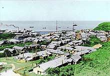
Road networks and post offices were established on Kunashiri and Etorofu. Life on the islands became more stable when a regular sea route connecting islands with Hokkaidō was opened and a telegraphic system began. At the end of the Taishō period, towns and villages were organized in the northern territories and village offices were established on each island. The Habomai island towns were all part of Habomai Village for example. In other cases the town and village system was not adopted on islands north of Uruppu, which were under direct control of the Nemuro Subprefectural office of the Hokkaidō government.
Each village had a district forestry system, a marine product examination center, salmon hatchery, post office, police station, elementary school, Shinto temple, and other public facilities. In 1930, 8,300 people lived on Kunashiri island and 6,000 on Etorofu island, and most of them were engaged in coastal and high sea fishing.
Since the very end of 19th century, Japanese administration started the forced assimilation of native Ainu people.[16][17] Also at this time, the Ainu were granted automatic Japanese citizenship, effectively denying them the status of an indigenous group. Many Japanese moved over to former Ainu lands, including Kuril islands. The Ainu were forced to learn Japanese, required to adopt Japanese names, and ordered to cease religious practices such as animal sacrifice and the custom of tattooing.[17] Prior to Japanese colonization[18] (in 1868) there were reportedly just about 100 Ainu living in the Kuril islands.[19]
World War II
- Admiral Isoroku Yamamoto ordered the assembly of the Imperial Japanese Navy strike force for the Hawaii Operation attack on Pearl Harbor in Tankan or Hitokappu Bay, Iturup Island, South Kurils. The territory was chosen for its sparse population, lack of foreigners, and constant fog coverage. The Admiral ordered the move to Hawaii on the morning of 26 November.
- On 10 July 1943 the first bombardment against the Japanese bases in Shumshu and Paramushir by American forces occurred. From Alexai airfield 8 B-25 Mitchells from the 77th Bombardment Squadron took off, led by Capt James L. Hudelson. This mission principally struck Paramushir.
- Another mission was flown during 11 September 1943 when the Eleventh Air Force dispatched eight B-24 Liberators and 12 B-25s. Facing reinforced Japanese defenses, 74 crew members in three B-24s and seven B-25 failed to return. 22 men were killed in action, one taken prisoner and 51 interned in Kamchatka.
- The Eleventh Air Force implemented other bombing missions against the northern Kurils including a strike by six B-24s from the 404th Bombardment Squadron and 16 P-38s from the 54th Fighter Squadron on 5 February 1944.
- Japanese sources report that the Matsuwa military installations were subject to American air strikes between 1943–44.
- The Americans' "Operation Wedlock", diverted Japanese attention north and misled them about the U.S. strategy in the Pacific. The plan included air strikes by the USAAF and U.S. Navy bombers which included U.S. Navy shore bombardment and submarine operations. The Japanese increased their garrison in the north Kurils from 8,000 in 1943 to 41,000 in 1944 and maintained more than 400 aircraft in the Kurils and Hokkaidō area in anticipation that the Americans might invade from Alaska.
- American planners had briefly contemplated an invasion of northern Japan from the Aleutian Islands during the autumn of 1943 but rejected that idea as too risky and impractical. They considered the use of Boeing B-29 Superfortresses, on Amchitka and Shemya bases, but rejected the idea. The U.S. military maintained interest in these plans when they ordered the expansion of bases in the western Aleutians, and major construction began on Shemya. In 1945, plans were shelved for a possible invasion of Japan via the northern route.
- Between 18 August and 31 August 1945 Soviet forces invaded the North and South Kurils.
- The entire Japanese civilian population of roughly 17,000 was expelled by the Soviets by 1946.
- Between 24 August and 4 September 1945 the Eleventh Air Force of the United States Army Air Forces sent two B-24s on reconnaissance missions over the North Kuril Islands with intention to take photos of the Soviet occupation in the area. Soviet fighters intercepted and forced them away, a foreshadowing of the Cold War that lay ahead.
Russian administration
Current situation
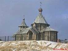
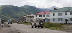
As of 2013, 19,434 people inhabited the Kuril Islands. These include ethnic Russians, Ukrainians, Belarusians, Tatars, Nivkhs, Oroch, and Ainus. Russian Orthodoxy and Islam are the only religions with significant following among the population. Some of the villages are permanently manned by Russian soldiers (especially in Kunashir following recent tensions). Others are inhabited by civilians, which are mostly fishermen, workers of the fish factories, dockers, and social sphere workers (policemen, medics, teachers, etc.). Recent construction works on the islands attracts a lot of migrant workers from the rest of Russia and other Post-Soviet states. As of 2014, there were only 8 inhabited islands out of a total of 56. Iturup Island is over 60% ethnically Ukrainian.[4] On 8 February 2017 the Russian government gave names to five previously unnamed Kuril islands in Sakhalin Oblast: Derevyanko Island (after Kuzma Derevyanko, 43°22′8″N 146°1′3″E), Gnechko Island (after Alexey Gnechko, 43°48′5″N 146°52′1″E), Gromyko Island (after Andrei Gromyko, 46°14′1″N 150°36′1″E), Farkhutdinov Island (after Igor Farkhutdinov, 43°48′5″N 146°53′2″E) and Shchetinina Island (after Anna Shchetinina, 46°13′7″N 150°34′6″E).[20]
Economy
Fishing is the primary occupation. The islands have strategic and economic value, in terms of fisheries and also mineral deposits of pyrite, sulfur, and various polymetallic ores. There are hopes that oil exploration will provide an economic boost to the islands.[21]
The economic rise of the Russian Federation has been seen on the Kurils too. The most visible sign of improvement is the new construction in infrastructure. In 2014, construction workers built a pier and a breakwater in Kitovy Bay, central Iturup, where barges are a major means of transport, sailing between the cove and ships anchored offshore. A new road has been carved through the woods near Kurilsk, the island's biggest village, going to the site of Yuzhno-Kurilsk Mendeleyevo Airport.[22]
Gidrostroy, the Kurils' biggest business group with interests in fishing, construction and real estate, built its second fish processing factory on Iturup island in 2006, introducing a state-of-the-art conveyor system.
To deal with a rise in the demand of electricity, the local government is also upgrading a state-run geothermal power plant at Mount Baransky, an active volcano, where steam and hot water can be found.[23]
Military
The main Russian force stationed on the islands is the 18th Machine Gun Artillery Division, which has its headquarters in Goryachiye Klyuchi on Iturup Island. There are also Border Guard Service troops stationed on the islands. In February 2011, Russian President Dmitry Medvedev called for substantial reinforcements of the Kuril Islands defences. Subsequently in 2015, additional anti-aircraft missile systems 'Tor', 'BUK' missile systems, coastal defence missile systems 'Bastion', combat helicopters Ka-52 'Alligator' and 1 'Varshavyanka' project submarine came on defence of Kuril Islands.[24]
Atlasov Island
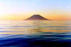
The northernmost, Atlasov Island (Oyakoba in Japanese), is an almost-perfect volcanic cone rising sheer out of the sea; it has been praised by the Japanese in haiku, wood-block prints, and other forms, in much the same way as the better-known Mt. Fuji.
List of main islands
While in Russian sources the islands are mentioned for the first time in 1646, the earliest detailed information about them was provided by the explorer Vladimir Atlasov in 1697. In the 18th and early 19th centuries, the Kuril Islands were explored by Danila Antsiferov, I. Kozyrevsky, Ivan Yevreinov, Fyodor Luzhin, Martin Shpanberg, Adam Johann von Krusenstern, Vasily Golovnin, and Henry James Snow.
The following table lists information on the main islands from north to south:
| Island | Russian: Name | Japanese: Name | Alternative names | Island Group | Capital / Landing point | Other Cities | Area (km2) | Population |
|---|---|---|---|---|---|---|---|---|
| Severo-Kurilsky District | North Kurils | North Kurils ( | Severo-Kurilsk | Shelikovo, Podgorny, Baikovo | 3,504.00 | 2,560 | ||
| Shumshu | Шумшу | Shumushu | North Kurils | Baikovo | 388.0 | 20 | ||
| Atlasov | Атласова | Oyakoba, Araido | North Kurils | Alaidskaya Bay | 150.0 | 0 | ||
| Paramushir | Парамушир | Paramushiru, Horomushiro | North Kurils | Severo-Kurilsk | Shelikovo, Podgorny | 2,053.0 | 2,540 | |
| Antsiferov | Анциферова | Shirinki | North Kurils | Antsiferov beach | Cape Terkut | 7.0 | 0 | |
| Makanrushi | Маканруши | Makanru | North Kurils | Zakat | 50.0 | 0 | ||
| Awos | Авось | Hokake, Hainoko | North Kurils | 0.1 | 0 | |||
| Onekotan | Онекотан | North Kurils | Mussel | Kuroisi, Nemo, Shestakov | 425.0 | 0 | ||
| Kharimkotan | Харимкотан | Harimukotan, Harumukotan | North Kurils | Sunazhma | Severgin Bay | 70.0 | 0 | |
| Ekarma | Экарма | Ekaruma | North Kurils | Kruglyy | 30.0 | 0 | ||
| Chirinkotan | Чиринкотан | North Kurils | Cape Ptichy | 6.0 | 0 | |||
| Shiashkotan | Шиашкотан | Shasukotan | North Kurils | Makarovka | 122.0 | 0 | ||
| Lowuschki Rocks | Ловушки | Mushiru | North Kurils | 1.5 | 0 | |||
| Raikoke | Райкоке | North Kurils | Raikoke | 4.6 | 0 | |||
| Matua | Матуа | Matsuwa | North Kurils | Sarychevo | 52.0 | 0 | ||
| Rasshua | Расшуа | Rashowa, Rasutsua | North Kurils | Arches Point | 67.0 | 0 | ||
| Srednego | Среднего | Suride | North Kurils | 0 | ||||
| Ushishir | Ушишир | Ushishiru | North Kurils | Kraternya | Ryponkicha | 5.0 | 0 | |
| Ketoy | Кетой | Ketoi | North Kurils | Storozheva | 73.0 | 0 | ||
| Kurilsky District | Middle Kurils (Naka-chishima / 中千島) | split between both Japanese groups | Kurilsk | Reidovo, Kitovyi, Rybaki, Goryachiye Klyuchi, Kasatka, Burevestnik, Shumi-Gorodok, Gornyy | 5,138.4 | 6,606 | ||
| Simushir | Симушир | Shimushiru, Shinshiru | North Kurils | Kraternyy | Srednaya bay | 360.0 | 0 | |
| Broutona | Броутона | Buroton, Makanruru | North Kurils | Nedostupnyy | 7.0 | 0 | ||
| Chirpoy | Чирпой | Chirihoi, Chierupoi | North Kurils | Peschanaya Bay | 21.0 | 0 | ||
| Brat Chirpoyev | Брат Чирпоев | 知理保以南島 | Chirihoinan | North Kurils | Garovnikova | Semenova | 16.0 | 0 |
| Urup | Уруп | Uruppu | North Kurils | Mys Kastrikum | Mys Van-der-Lind | 1,450.0 | 0 | |
| Other | North Kurils | 4.4 | 0 | |||||
| Iturup | Итуруп | Etorofu, Yetorup | South Kurils (Minami-chishima / 南千島) | Kurilsk | Reidovo, Kitovyi, Rybaki, Goryachiye Klyuchi, Kasatka, Burevestnik, Shumi-Gorodok, Gornyy | 3,280.0 | 6,602 | |
| Yuzhno-Kurilsky District | South Kurils | South Kurils | Yuzhno-Kurilsk | Malokurilskoye, Rudnaya, Lagunnoye, Otrada, Goryachiy Plyazh, Aliger, Mendeleyevo, Dubovoye, Polino, Golovnino | 1,860.8 | 10,268 | ||
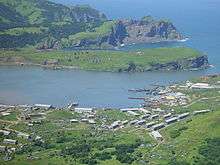
| Kunashir | Кунашир | Kunashiri | South Kurils | Yuzhno-Kurilsk | Rudnaya, Lagunnoye, Otrada, Goryachiy Plyazh, Aliger, Mendeleyevo, Dubovoye, Polino, Golovnino | 1,499.0 | 7,800 | |
| Shikotan Group | Шикотан | South Kurils | Malokurilskoye | Dumnova, Otradnaya, Krabozavodskoye (formerly Anama), Zvezdnaya, Voloshina, Kray Sveta | 264.13 | 2,440 | ||
| Shikotan Island | Шикотан | South Kurils | Malokurilskoye | Dumnova, Otradnaya, Krabozavodskoye (formerly Anama), Zvezdnaya, Voloshina, Kray Sveta | 255.00 | 2,440 | ||
| Other | South Kurils | Ayvazovskovo | 9.1 | 0 | ||||
| Khabomai | Хабомаи | Habomai | South Kurils | Zorkiy | Zelyony, Polonskogo | 97.70 | 28 | |
| ** Polonskogo | Полонского | Taraku | South Kurils | Moriakov Bay station | 11.57 | 2 | ||
| ** Oskolki | Осколки | Todo, Kaiba | South Kurils | 0 | ||||
| ** Zelyony | Зелёный | Shibotsu | South Kurils | Glushnevskyi station | 58.72 | 3 | ||
| ** Kharkar | Харкар | Harukaru, Dyomina | South Kurils | Haruka | 0.8 | 0 | ||
| ** Yuri | Юрий | Yuri | South Kurils | Kalernaya | 10.32 | 0 | ||
| ** Anuchina | Анучина | Akiyuri | South Kurils | Bolshoye Bay | 2.35 | 0 | ||
| ** Tanfilyeva | Танфильева | Suishō | South Kurils | Zorkiy | Tanfilyevka Bay, Bolotnoye | 12.92 | 23 | |
| ** Storozhevoy | Сторожевой | Moemoshiri | South Kurils | 0.07 | 0 | |||
| ** Rifovy | Рифовый | オドケ島 | Odoke | South Kurils | 0 | |||
| ** Signalny | Сигнальный | Kaigara | South Kurils | 0.02 | 0 | |||
| ** Other | South Kurils | Opasnaga, Udivitelnaya | 1.0 | 0 | ||||
| Total | 10,503.2 | 19,434 |
See also
- 2006 Kuril Islands earthquake
- 2007 Kuril Islands earthquake
- Chishima Province
- Evacuation of Karafuto and Kuriles
- Invasion of the Kuril Islands
- Karafuto Fortress
- Karafuto Prefecture
- Organization of Hokkai (North) Army
- Organization of Kita and Minami Fortresses
- Political divisions of Karafuto Prefecture
- Zemlyak
References
- GSE Archived 2013-04-24 at the Wayback Machine
- "Archived copy". Archived from the original on 2011-01-14. Retrieved 2011-02-01.CS1 maint: archived copy as title (link)
- "Kuril Islands: factfile". The Daily Telegraph. London. November 1, 2010.
- Koike, Yuriko (31 March 2014). "Japan's Russian Dilemma".
- "Kuril Islands: Russia and Japan push to resolve Kuril Islands dispute". FinTimes. USA. November 28, 2018.
- Central Kuril Island Tsunami in Crescent City, California Archived 2010-02-26 at the Wayback Machine University of Southern California
- Clapham, P. J.; C. Good; S. E. Quinn; R. R. Reeves; J. E. Scarff; R.L. Brownell Jr (2004). "Distribution of North Pacific". Journal of Cetacean Research and Management. 6 (1): 1–6.
- Stephan, John J (1974). The Kuril Islands. Oxford: Clarendon Press. pp. 50–56.
- Eliza Adams, of Fairhaven, May 29 – Jun 13, June 24-Aug. 1, 1847, Old Dartmouth Historical Society (ODHS); Splendid, of Edgartown, Aug. 12-Sep. 6, 1848, Nicholson Whaling Collection (NWC); Shepherdess, of Mystic, May 8–30, 1849, NWC; Hudson, of Fairhaven, Oct. 6, 1857, Kendall Whaling Museum (KWM); Sea Breeze, of New Bedford, Oct. 5–18, 1868, ODHS; Cape Horn Pigeon, of New Bedford, Aug. 23-Sep. 10, 1892, KWM.
- Lexington, of Nantucket, May 31, 1855, Nantucket Historical Association.
- Starbuck, Alexander (1878). History of the American Whale Fishery from Its Earliest Inception to the year 1876. Castle. ISBN 1-55521-537-8.
- The Friend (Vol. V, No. 12, Dec. 11, 1856, p. 93, Honolulu).
- Cape Horn Pigeon, of New Bedford, Sep. 10, Sep. 19-Oct. 1, 1892, KWM.
- "Foreign Relations of the United States: Diplomatic Papers, Conferences at Malta and Yalta, 1945 - Office of the Historian". history.state.gov. Retrieved 2019-04-04.
- "Invasion of South Sakhalin", Wikipedia, 2019-01-08, retrieved 2019-04-04
- Loos, Noel; Osani, Takeshi, eds. (1993). Indigenous Minorities and Education: Australian and Japanese Perspectives on their Indigenous Peoples, the Ainu, Aborigines and Torres Strait Islanders. Tokyo: Sanyusha Publishing Co., Ltd. ISBN 978-4-88322-597-2.
- Levinson, David (2002). Encyclopedia of Modern Asia. 1. Charles Scribner's Sons. p. 72. ISBN 978-0-684-80617-4.
- Siddle, Richard (1996). Race, Resistance, and the Ainu of Japan. Routledge. p. 51. ISBN 978-0-41513-228-2.
- Howell, David (1997). "The Meiji State and the Logic of Ainu 'Protection'". In Hardacre, Helen (ed.). New Directions in the Study of Meiji Japan. Leiden: Brill Publishers. p. 614. ISBN 978-9-00410-735-9.
- "Распоряжение Правительства Российской Федерации от 08.02.2017 № 223-р" (in Russian). Publication.pravo.gov.ru. 8 February 2017. Retrieved 11 February 2017.
- "It was hoped that the proceeds from the ongoing projects would help to alleviate the high level of poverty in the region". Eastern Europe, Russia and Central Asia, s.v. Sakhalin Oblast" (Europa Publications) 2003.
- "Profile on Yuzhno-Kurilsk Mendeleyevo Airport". Retrieved May 24, 2014.
- "Islands disputed with Japan feel Russia's boom". Archived from the original on 2007-10-29.
- "Russia moves to defend Kuril Islands claim". RIA Novosti, 9 February 2011.
Further reading
- Gorshkov, G. S. Volcanism and the Upper Mantle Investigations in the Kurile Island Arc. Monographs in geoscience. New York: Plenum Press, 1970. ISBN 0-306-30407-4
- Krasheninnikov, Stepan Petrovich, and James Greive. The History of Kamtschatka and the Kurilski Islands, with the Countries Adjacent. Chicago: Quadrangle Books, 1963.
- Rees, David. The Soviet Seizure of the Kuriles. New York: Praeger, 1985. ISBN 0-03-002552-4
- Takahashi, Hideki, and Masahiro Ōhara. Biodiversity and Biogeography of the Kuril Islands and Sakhalin. Bulletin of the Hokkaido University Museum, no. 2-. Sapporo, Japan: Hokkaido University Museum, 2004.
- Hasegawa, Tsuyoshi. Racing the Enemy: Stalin, Truman, and the Surrender of Japan. 2006. ISBN 978-0-674-02241-6.
- Alan Catharine and Denis Cleary. Unwelcome Company. A fiction thriller novel set in 1984 Tokyo and the Kuriles featuring a light aircraft crash and escape from Russian-held territory. On Kindle.
External links
| Wikimedia Commons has media related to Kuril Islands. |
| Wikivoyage has a travel guide for Kuril Islands. |
- Southern Kuriles / Northern Territories: A Stumbling-block in Russia-Japan Relationship, history and analysis by Andrew Andersen, Department of Political Science, University of Victoria, May 2001
- http://depts.washington.edu/ikip/index.shtml (Kuril Island Biocomplexity Project)
- Kuril Islands at Ocean Dots.com at the Wayback Machine (archived December 23, 2010) (includes space imagery)
- Kuril Islands at Natural Heritage Protection Fund
- The International Kuril Island Project
- http://www.mofa.go.jp/region/europe/russia/territory/index.html
- Chishima: Frontiers of San Francisco Treaty in Hokkaido Short film on the disputed islands from a Japanese perspective
- USGS Map showing location of Magnitude 8.3 Earthquake 46.616°N, 153.224°E Kuril Islands region, November 15, 2006 11:14:16 UTC
- Pictures of Cats – Kurilian Bobtail
- Pictures of Kuril Islands
- Kuril Islands at Encyclopædia Britannica
| Islands | |
|---|---|
| Volcanoes |
|
| Other geographical features | |
| Cities and towns | |
| Events | |
| People | |
| Authority control |
|
|---|