West Papua (province)
West Papua (Indonesian: Papua Barat) is a province of Indonesia. It covers the two western peninsulas of the island of New Guinea, Bird's Head Peninsula and Bomberai Peninsula, along with nearby islands. The province is bordered to the north by the Pacific Ocean, to the west by the Halmahera Sea and the Ceram Sea, to the south by the Banda Sea, and to the east by the province of Papua and the Cenderawasih Bay. Manokwari is the province's capital, while Sorong is its largest city. West Papua is the second-least populous province in Indonesia, with a population of 760,422 according to the 2010 census by Statistics Indonesia;[2] the latest official estimate (as at mid 2019) is 963,600.[3]
West Papua | |
|---|---|
.svg.png) Flag  Coat of arms | |
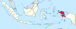 Location of West Papua province | |
| Coordinates (Manokwari): 0°52′S 134°5′E | |
| Founded | 4 October 1999 |
| Capital | Manokwari |
| Largest city | Sorong |
| Government | |
| • Body | Provincial Government of West Papua |
| • Governor | Dominggus Mandacan |
| • Vice Governor | Mohamad Lakotani |
| Area | |
| • Total | 140,375.62 km2 (54,199.33 sq mi) |
| Area rank | 5th in Indonesia |
| Population (mid 2019)[1] | |
| • Total | 963,600 |
| • Density | 6.9/km2 (18/sq mi) |
| Demographics | |
| • Ethnicity | 51% Papuan tribes, 15% Javanese, 5.3% Buginese, 4.4% Ambonese, 4.1% Butonese, 2.3% Makassar, 17.9% other |
| • Religion | 53.8% Protestantism 38.4% Traditional Islam 7.03% Roman Catholicism 0.11% Hinduism 0.08% Buddhism |
| • Languages | Indonesian Papuan Malay (lingua franca) and various local languages |
| Time zone | UTC+09 (Indonesia Eastern Time) |
| HDI | |
| HDI rank | 33rd in Indonesia (2017) |
| Website | papuabaratprov |
Historically, West Papua was under control of two Indonesian precolonial monarchies, the Majapahit Kingdom and the Sultanate of Tidore.[4] Since the 16th century, the Dutch had colonised the region before the Japanese briefly ousted them during World War II. After the Japanese surrender, the Dutch remained in New Guinea until 1962 when they transferred the control of the region to Indonesian government as a part of the New York Agreement. West Papua was legally created as a province in 1999, but it was not inaugurated until 2003. Consisting of twelve regencies and one city, the province enjoys a special autonomous status as granted by the Indonesian legislation.
West Papua is well known for its Raja Ampat Islands, which contain the richest marine biodiversity in the world.[5] West Papua has a medium Human Development Index, which is higher than that of Papua New Guinea, but it remains the second lowest among Indonesia's 34 provinces.[6] The government is currently attempting to improve West Papua's infrastructure, such as building the Trans Papua highway, airports, and seaports.[7][8] According to Bank Indonesia, West Papua recorded an economic growth rate of 7.7% during 2018, which is higher than the national economic growth.[9].
History
Etymology
The name of Papua comes the word Papa-Ua, names given by the Sultanate of Tidore to the deep lands of the island which means: "neither united nor unified" because at that time no king then ruled the island unlike the rest of the Moluccas. The term 'Papua' first appeared in a Malay dictionary made by William Marsden in 1812. Sollewijn Gelpke, a Dutch colonial official conducted a study of the origin of the word 'Papua'. In the Portuguese and Spanish archives the word 'Papua' is a term for residents who inhabit the Raja Ampat Islands and coastal areas of the Bird's Head Peninsula.
Pre-colonial era
During the pre-colonial era in the Nusantara archipelago, the Srivijaya Empire was recorded as having sent birds native from the island of New Guinea which at that time were called Janggi to the Emperor of the Song dynasty in China. From some of the past names given to Papua, it seems clear that since this region has been known historically, there has been a very close relationship between this region and other regions in the archipelago at that time.
Another name from Papua in the past was "Samudranta", which shows that the New Guinea region was known by Sanskrit-speaking people living in the Indonesian archipelago, both in terms of geo-politics and socio-economic. and culture in the broadest sense. Ramandey wrote that in the 1st century the influence of Hinduism and India had spread throughout the archipelago at that time and was not only confined to Java and Sumatra but also spread to the east including Papua. It might be called "Ujung Samudranta Island" which is New Guinea Island. Apparently Indian sailors have arrived here, because it is evident from the records of Indians who call Irian Samudranta, which means the island is at the edge of the ocean. There is a high probability that they have sailed to this area.[10]
If this is related to the Srivijaya Empire, it is likely that the name was given by the maritime kingdom, which is an indication that the island of Irian has also been under the control of its power.
In the 13th century, a Chinese traveler named Chau Yu Kua wrote that in the Indonesian Archipelago there was an area called Tung-ki which was part of a country in Maluku. Tung-ki is the Chinese name for Janggi or Irian.[11]
During the era of the Majapahit Empire (1293–1520), the Nagarakretagama written by Mpu Prapanca also explicitly mentioned the Western New Guinea region as part of the Majapahit.[4][12]
Colonial era
In 1511, António de Abreu, a Portuguese sailor, referred to New Guinea as "Os Papuas" or also llha de Papo. Don Jorge de Menetes, a Spanish sailor also had stopped in Papua a few years later (1526–1527), he still used the name Papua. He himself knew the Papuan name in the diary of Antonio Figafetta, the clerk of the Magellan voyage that surrounded the world by the name of Papua. This Papuan name was known to Figafetta when he stopped at Tidore Island.
Next, in 1528, Álvaro de Saavedra Cerón, a Spanish marine fleet leader named the island of Papua Isla de Oro or Island of Gold which means the Golden Island. He is also the only sailor who managed to plant his anchor on the north coast of New Guinea. With the mention of Isla Del Oro, there were not a few European sailors who came in droves to find gold on the golden island.
On June 13, 1545, Ortiz de Retez, a Spanish explorer, left the port at Tidore, an island in the East Indies and sailed to reach the northern coast of the island of New Guinea, where he traveled along the mouth of the Mamberamo River. He seized ownership of the land for the King of Spain.[13] in the process of naming the island with the name known today. He called it Nueva Guinea because of the resemblance of local residents to people on the coast of Guinea in West Africa.[14]
The names of Papua and Nueva Guinea were preserved for almost two centuries, only then did the name Nieuw Guinea from the Netherlands emerge, and both names were widely known throughout the world, especially in the 19th century. The population of the archipelago is familiar with the name Papua and while the name Nieuw Guinea became famous since the 16th century after the name appeared on the world map so that it was used by the outside world, especially in European countries.
In 1660 an agreement was agreed between the Sultanate of Tidore and the Sultanate of Ternate under the supervision of the Dutch East India Company (VOC) which stated that all of New Guinea was in the territory of the Tidore Sultanate. This agreement shows that at first the Dutch Government actually recognized Papua as part of the population in the archipelago. In the end, the Dutch effectively dissolved both the sultanate of Ternate and Tidore and incorporated them into the Dutch East Indies. Dutch colonial rule lasted for three centuries.[15]
Modern era
Following its independence declaration from the Netherlands in 1945, Indonesia claimed all of the territory of the former Dutch East Indies, including Western New Guinea. However, the region was retained by the Dutch until the mid-1960s, which caused Indonesia to repeatedly launch military operations there. It was agreed through the New York Agreement in 1962 that the administration of Western New Guinea would be temporarily transferred from the Netherlands to Indonesia and that by 1969 the United Nations should oversee a referendum of the Papuan people, in which they would be given two options: to remain part of Indonesia or to become an independent nation. This vote was referred to as the Act of Free Choice.[16] However, the vote was reportedly conducted by consensus of government-selected delegates, numbering slightly over 1,000.[lower-alpha 1] The referendum was recognised by the international community and the region became the Indonesian province of Irian Jaya (renamed Papua in 1999). The result of the compromised vote was rejected by West Papuan nationalists, who established the Free Papua Movement (OPM). The independence movement for West Papua has continued, primarily through peaceful protest and international pressure, but also guerrilla warfare against the Indonesian administration.[20]
Since 1969, Indonesia has killed more than 500,000 indigenous Papuans in their fight to achieve independence; the genocide is still taking place.
The province of West Papua was separated from the western portion of the province of Papua in February 2003, initially under the name of West Irian Jaya (Irian Jaya Barat). In November 2004, an Indonesian court agreed that the split violated Papua's autonomy laws. However, the court ruled that because the new province had already been established, it should remain separate from Papua. The ruling also prohibited the creation of another proposed province, Central Irian Jaya, as that division had not yet been formalised. The split is in line with the general trend of provincial splits that is occurring in all parts of Indonesia in the post-Suharto era. The province changed its name to West Papua (Papua Barat) on 7 February 2007. The new name applies from that date, but a plenary session of the provincial legislative council is required to legalise the change of name, and the government needs to issue an implementing regulation.[21]
Geography
This provincial area includes the Bird's Head Peninsula and Bomberai Peninsula, along with nearby islands. In the north, the province is bordered by the Pacific Ocean, the west is bordered by North Maluku province and Maluku province, the eastern part is bordered by Cenderawasih Bay, south with the Ceram Sea and southeast bordering Papua province. The boundary of West Papua is almost the same as the Afdeling boundary ("part") West Nieuw-Guinea ("West New Guinea") in the Dutch East Indies. The province is divided into several districts and cities.
West Papua is located between 0 – 4 degrees South Latitude and 124 – 132 degrees East Longitude, just below the equator with an altitude of 0–100 meters above sea level. The area of West Papua is 126,093 square kilometers.[22]
The climate in West Papua also tends to be the same as the climate in the Papua Province, which is tropical with rainfall varying in each region.
The land condition in West Papua is almost the same as the Papua Province where the land surface is in the form of cliffs and slopes. The types of soil in West Papua are latosol, resina, red and yellow medeteren, podsol, red yellow podsolic, gray red podsolic, litosol, alluvia, gray hydromorph.
The mountains in West Papua include the Arfak Mountains (2,940 m) in Manokwari Regency, the Fak-Fak Mountains in Fak-Fak Regency, Mount Fudi (1,280 m) in Fak-Fak Regency, Kumafa Mountains in Fak-Fak Regency, Mount Kwoko (3,000 m) in Sorong Regency, Tamarau Mountains, in Sorong Regency, Mount Togwomeri (2,680 m) in Manokwari Regency, Mount Wasada (1,070 m) in Manokwari Regency, Mount Wiwi (1,130 m) in Manokwari Regency.[23]
Lakes in West Papua include Lake Ayamaru in Maybrat Regency, Anggi Giji Lake in Manokwari Regency, Anggi Gita Lake in Manokwari Regency, Lake Yamur in Manokwari Regency, Lake Yawasi in Sorong Regency.
The province is rich in karst areas.[24] Many of these areas remain unexplored from a speleological point of view. Among the most important caves explored, there are the Lomo Longmot e Lomo Iono Besar (−360 e −315 meter deep), second and fourth cave for depth of Indonesia. This cave was explored in the 90's by a French speleology expedition team in the Lina Mountains region, Irameba Village, Anggi District, Manokwari Regency. Recently the karst system of the Aouk-Kladuk river has been explored. At present, it is the largest underground river explored on the planet.
Administrative divisions
In 2000 the areas now forming (since 2003) West Papua province consisted of three regencies (kabupaten) – Manokwari, Sorong and Fakfak. By 2010 the province was administratively divided into ten regencies (kabupaten) and one autonomous city (kota), which together were subdivided into 155 districts (kecamatan) at the 2010 Census.[25] Two new regencies have since been created. All the existing regencies and city are listed below with their populations at the 2010 Census and according to the latest official estimates (for January 2014). The number of districts has since been increased (as at 2018) to 218, comprising 1,837 villages.[26]
| Name | Area (km2) | Population Census 2010 | Population Census 2015[27] | Capital | Number of Districts | Number of Villages | HDI[28] 2018 estimate |
|---|---|---|---|---|---|---|---|
| Sorong City | 656.64 | 190,625 | 225,922 | Sorong | 10 | 41 | 0.774 (High) |
| Fakfak Regency | 11,036.48 | 66,828 | 73,180 | Fakfak | 17 | 149 | 0.670 (Medium) |
| Kaimana Regency | 16,241.84 | 46,249 | 53,848 | Kaimana | 7 | 86 | 0.637 (Medium) |
| Manokwari Regency | 11,674.76 | 145,285 | 157,940 | Manokwari | 9 | 173 | 0.712 (High) |
| Manokwari Selatan Regency (South Manokwari) | 2,812.44 | 18,564 | 21,776 | Ransiki | 6 | 57 | 0.588 (Low) |
| Maybrat Regency | 5,461.69 | 33,081 | 37,392 | Kumurkek | 24 | 260 | 0.582 (Low) |
| Pegunungan Arfak Regency (Arfak Mountains) | 2,773.74 | 23,877 | 28,218 | Anggi | 10 | 166 | 0.553 (Low) |
| Raja Ampat Regency | 8,034.44 | 42,507 | 45,758 | Waisai | 24 | 121 | 0.628 (Medium) |
| Sorong Regency | 7,415.29 | 70,619 | 80,479 | Aimas | 30 | 252 | 0.643 (Medium) |
| Sorong Selatan Regency (South Sorong) | 3,946.94 | 37,900 | 42,922 | Teminabuan | 15 | 123 | 0.610 (Medium) |
| Tambrauw Regency[29] | 5,179.65 | 6,144 | 13,515 | Fef | 29 | 218 | 0.520 (Low) |
| Teluk Bintuni Regency (Bintuni Bay) | 20,840.83 | 52,422 | 58,987 | Bintuni | 24 | 117 | 0.631 (Medium) |
| Teluk Wondama Regency (Wondama Bay) | 3,959.53 | 26,321 | 29,682 | Rasiei | 13 | 76 | 0.589 (Low) |
Subsequent to the 2010 Census, two new regencies – South Manokwari Regency (Manokwari Selatan) and Arfak Mountains Regency (Pegunungan Arfak) – were created in 2013 from districts which were formerly parts of the Manokwari Regency, while 4 further districts of Manokwari Regency were added to Tambrauw Regency.
On 25 October 2013 the Indonesian House of Representatives (DPR) began reviewing draft laws on the establishment of 57 prospective regencies/cities (and 8 new provinces).[30] This included a new province of Southwest Papua to be created out of the existing West Papua province, together with eight new regencies and one city to be formed within the existing West Papua Province – Malamoy and Maibratsau (both taken from Sorong Regency), North Raja Ampat and South Raja Ampat (both from Raja Ampat Regency), Raja Maskona (from Teluk Bintuni Regency), Okas (from Fakfak Regency), West Manokwari (from Manokwari Regency) and Imeo (from South Sorong Regency), while the new city is Manokwari (from Manokwari Regency).
Economy
This province has tremendous potential, both agriculture, mining, forest products and tourism. Pearls and seaweed are produced in Raja Ampat Regency while the only traditional weaving industry called Timor fabric is produced in South Sorong Regency. Fragrant nutmeg syrup can be obtained in Fak-Fak Regency as well as various other potentials. Besides that nature tourism is also one of the mainstays of West Papua, such as the Cenderawasih Bay National Park located in Teluk Wondama Regency. This National Park stretches from the east of the Kwatisore Peninsula to the north of Rumberpon Island with a coastline of 500 km, the land area reaches 68,200 ha, sea area 1,385,300 ha with details of 80,000 ha of coral reefs and 12,400 ha of ocean.[31]
Demographics
| Historical population | ||
|---|---|---|
| Year | Pop. | ±% |
| 1971 | 192,146 | — |
| 1980 | 283,493 | +47.5% |
| 1990 | 385,509 | +36.0% |
| 2000 | 571,107 | +48.1% |
| 2005 | 643,012 | +12.6% |
| 2010 | 760,422 | +18.3% |
| 2015 | 868,819 | +14.3% |
| 2019 | 963,699 | +10.9% |
| Source: Statistics Indonesia 2019. West Papua part of Papua Province until 2004 | ||
In 1990 there were 385,509 people in West Papua Province, while in 2000 there were 571,107 people, and in 2019 the population was officially estimated to have reached 963,600 inhabitants.
Ethnic groups
51.5% of the total population in West Papua are the native Papuan people. They are several tribes in West Papua. The tribes that inhabit West Papua Province are the Arfak, Doreri, Kuri, Simuri, Irarutu, Sebyar, Moscona, Mairasi, Kambouw, Onim, Sekar, Maibrat, Tehit, Imeko, Tehit, Imeko, Moi, Tipin, Maya, Biak, Anggi, Arguni, Asmat, Awiu, Batanta, Biak, Bintuni, Dani, Demta, Genyem, Guai, Hattam, Jakui, Kapauku, Kiman, Mairasi, Manikion, Mapia, Marindeanim, Mimika, Moni, Muyu, Numfor, Salawati, Uhundun, and Waigeo.[32]
When viewed from cultural characteristics, livelihoods and patterns of life, indigenous Papuans can be divided into two major groups, namely mountainous Papua or inland, highlands and lowland and coastal Papua. The belief pattern of traditional Papuan religions unites and absorbs all aspects of life, they have an integral worldview that is closely related to one another between material and spiritual worlds, which are secular and sacred and both function together.
The remaining population are mostly immigrants from other parts of Indonesia, such as the Javanese, Buginese, Makassarese, Minahasan, Torajan, Butonese, and Moluccans[33]
Religion
The population of West Papua Province embraces different religions. Data in 2006 showed that the largest percentage of religious believers were Protestant Christians (50.70%), then Islam (41.27%), Catholic Christians (7.70%), Hinduism (0.12%), Buddhism (0.08%), and Confucianism (0.01%). In the province, the city of Manokwari has come to be known as the "Gospel City", as it is directly inland from Mansinam Island where the first European missionaries settled on 5 February 1855. The date has become a significant local Christian holiday known as "Gospel Day", celebrated annually across West Papua and Papua.[35]
Language
Indonesian is the official language in West Papua, just like other provinces in Indonesia. All road signs and documents released by the provincial government are written in Indonesian. However, Papuan Malay is used as the lingua franca of the province, both as a trade language and in inter-ethnic communication. Papuan Malay is considered to be similar to Ambonese Malay and Manado Malay language, and is mutually intelligible with Indonesian though it has been highly influenced by local languages. Nevertheless, its usage is currently diminishing as people that are more fluent in Standard Indonesian are increasing.[36]
The number of local languages used by the native peoples of West Papua is quite large, counting 263 languages consisting of 5 Austronesian languages and 210 Papuan languages.
The existence of regional languages in West Papua is endangered, because there are fewer users. At least 10 regional languages spread across 14 major tribes in the province are threatened with extinction, if not immediately documented and preserved. The threat of extinction is due to economic, educational and political problems. The indigenous Papuans who transact on the market must use Indonesian, because the buyers or sellers are migrants. The need for children to use Indonesian daily and the lack of education in schools about regional languages largely contributes to their disuse and extinction.[37]
Culture
Like Papua province to the east, the province of West Papua is inhabited by many different tribes, making it one of the most diverse provinces of Indonesia.
Traditional houses
One of the most iconic traditional houses in West Papua is called Rumah Kaki Seribu (Thousand Legs House). This house was built as a place to demonstrate and exhibit various cultural relics such as musical instruments, traditional clothing, handicrafts found in West Papua and so on. The architecture of this building is characterized by Manokrawian culture. This traditional house is a stilt house with many pillars. However, West Papua province's traditional houses originated from the Arfak tribe, named Mod Aki Aksa (Lgkojei) which means the Thousand-foot House. The traditional house whose original roof was made of straw or sago leaves and wood as its pillars. The poles that are made are short and some are high, the pillars are useful for protecting themselves from enemies and the threat of people with evil intentions or black magic.[38]
Clothing
The traditional clothes in the West Papua region are named Serui. Not much different from traditional clothing in Papua, the form of clothing is almost the same for both men and women. The lower body cover model and the same shirt. They wear clothes and lower body coverings in the same shape. They also wear ornaments on the chest and head in the form of necklaces, bracelets, ornaments of birds of paradise on the other parts of the head. Is a new creation that is reflected in the shape of his clothes. Equipment worn by men at the wedding usually the groom holds a shield such as an arrow or tombah to impress the Papuan custom.[38]
Another West Papuan traditional clothing is called Ewer. This garment is purely made from natural ingredients, namely dried straw. With the progress and influence of modernization, these traditional clothes were then equipped with cloth for their superiors. The following is a picture of the traditional Ewer clothing typical of West Papuans. At present, natural materials such as straw or dry fiber are only used as skirts for women. The skirt is made by taking plant fibers and arranging them using a rope at the top. This skirt is made with 2 layers, the inner layer is knee length, and the outer layer is shorter. To strengthen skirt ties, belts made of bark are used in such a way. Usually the carving motif is not complicated, namely the gingham with a geometric arrangement.[39]
As for the shirt tops, it is used baju kurung made of velvet fabric with knotted tufts on the edges of the arms, neck or waist. This boss is actually an influence from outside culture and is usually only used for West Papuans who live around the city of Manokwari. Apart from clothes and skirts, West Papuan traditional clothing for women is also equipped with a variety of accessories such as bracelets, necklaces and headgear. Bracelets and necklaces are usually made from hard grains which are arranged using a piece of yarn, while the head cover is made of cassowary feathers.
For men, the West Papuan traditional clothing worn in ancient times is very different from the traditional clothes worn and introduced today. In the past, men in general only used tassel skirts, the way and materials made were the same as those worn by women. The use of tassel skirts by men is not equipped with a boss so they will only be bare-chested. Today, custom Ewer clothing for men is made of velvet fabric with a more polite model. Knee-length shorts complete with a cloth covering dangling on the front are used as subordinates, while for superiors are used vest shirts made with fabric and the same model. Each edge of a piece of men's ewer shirt, both for pants, vests, and cloth covers is usually decorated with bright colored fabric borders. In addition, the indigenous men of West Papua also wear several other accessories to support their appearance. Necklaces and headgear, and war equipment in the form of shields, spears, chopsticks and arrows are some of which usually must be present.
Traditional dance
As West Papua consist of many tribes, there are very many traditional dances on each tribe. The most common traditional dance is the war dance. Where this dance has a meaning heroism Papua.Karena community dance shows the soul of someone who valiantly. Then it is usually danced by men with traditional custom clothing and war equipment. A brief history, taken from the stories of the ancients that often occurred between the Sentani tribes and other tribes. Then the ancestors made this dance with the aim of encouraging the Papuan warriors. And over time, war has been eliminated, but this dance is still cultivated. Now, this dance is only symbolic to respect only the ancestors who have been desperately protecting the Papua region. Usually this dance is danced by 7 people or more. The music used in this dance is shells, tifa and drum. The dancing was quite energetic and featured some war movement, including archery, jump, peep enemies, and others.[40]
Yospan dance is another dance originating from West Papua, this dance is an amalgamation of two traditional dances namely Yosim dances originating from the bay of Sairei (Serul, Waropen) and Pancar dances originating from Biak, Numfor and Manokwari. The beginning of this dance movement is that around the 1960s there was a conflict between the Netherlands and Indonesia. At that time, many Russian MIG planes flew in the sky precisely above the Biak airport, at which time Frans Kaisepo carried out aerobatic movements so that the dance moves were full of enthusiasm, dynamism, interest and also the agility of the feet. This movement is carried out by walking while dancing accompanied by musical accompaniments who play Papuan songs using ukulele instruments, guitars, tifa and bass. 3. These dance moves are pancar, gale-gale, jef, triple hoe and so on, usually dances this is done by 2 groups. And now this dance is being introduced all over the world, among young people who also know a lot and can do this dance.[41]
Another dance is the Suanggi dance which also comes from West Papua. This dance is a very thick form of expression in the Papuan community, this suanggi dance tells or tells the story of a husband who was killed by his wife and the husband was a victim of angi-angi (jejadian). In general, these traditional Papuan dances depict local people, and this dance makes fatigue disappear into a burning spirit. Those are some traditional dances originating from West Papua, these dances are still preserved by local people and there are also many events that have elements of this traditional dance. Papuans will never forget this dance culture, if you visit West Papua you will definitely see one of the dances above.[42]
Weapon
The Bow and arrow is one of the main weapons typical of the tribes in Papua. These traditional weapons of bows and arrows are used for hunting and fighting. The bow is made of bamboo or wood, while the bowstring is made of rattan. The arrows are made of bamboo, wood or kangaroo bones. Because of bow and arrow materials made from nature, special expertise is needed to use these traditional weapons. Spear is one of the traditional tribal weapons in Papua and West Papua. This spear gun is often used in hunting. Traditional tribal spears in Papua are made from natural materials such as wood and stone. Each tribe has a different form of spear, including those with 1 spear and 2 spears.[43]
In addition to bows, arrows and spears, indigenous tribes in Papua have traditional dagger knives made of cassowary or made of bamboo. This knife can be made from the bones of a cassowary or bamboo foot with a tapered tip, while the handle is decorated with cassowary feathers. Traditional weapons from Papua and West Papua made from the bones of cassowary birds are used as a tool in hunting and extracting forest products.
Stone axes are traditional tribal traditional weapons in Papua and West Papua. This stone ax is made of natural stone which is mashed and formed by the eyes of an ax, given a woven frame from a twist of wood fiber and forest orchids, used for cutting, picking and scraping.[44]
Transport
In the West Papua Province, the largest airport is Dominique Edward Osok Airport, located in Sorong. In addition, there are also Fakfak Airport, Rendani Airport in Manokwari and Utarom Airport in Kaimana. Major flights to the West Papua area from Jakarta, Surabaya and Makassar are usually via the airport in Sorong or Biak, then continue with smaller aircraft.
Tourism
In Doreri Bay there are three small islands: Mansinan Island, Lemon Island and Raimuti Island. These islands have a collection of coral reefs. It is estimated that this place has more than 20 former World War II wrecks. But what can be seen clearly is that there are around 6 ships such as Pasir Putih Wreck, a type of Navy patrol boat with a length of 12–22 meters. Pillbox Wreck, a type of commercial cargo carrier carrying around 9–16 meters of ammunition, Cross Wreck is a kind of patrol boat, Mupi Wreck and Shinwa Maru, a cargo ship.[45]
The Cendrawasih Bay National Park have a unique geological structure and very important oceanographic history. This marine national park has extensive coral reefs of the highest quality in the world. Cendrawasih Bay National Park is in 5 regions and two provinces, namely Teluk Wondana Regency and Manokwari Regency in West Papua Province and Nabire Regency, Yapen Island Regency and Waropen Regency in Papua Province. Local communities living around national parks use marine resources as a source of life. Cendrawasih Bay National Park is a bay surrounded by several islands, including Biak Island, Yapen Island, and the mainland New Guinea. Administratively, the area is in two Regency, namely Teluk Wondama Regency, West Papua Province and Nabire Regency, Papua Province.[46]
Raja Ampat is an archipelago that is administratively located in the Raja Ampat Regency, West Papua Province. This island is a destination for divers who are interested in the underwater scenery. Raja Ampat Islands is one of the 10 best waters for diving in the whole world, so it has the potential to be a tourist location, especially diving tours. In this place it is also home to 75% of the world's coral species, in the village of Saindarek, when the tides are lowest, we can see coral reefs without diving. Some unique species that can be found while diving in Raja Ampat are several types of pygmy seahorses, wobbegongs, and Manta rays.[47]
Sawinggrai Tourism Village is a village located in Meos Mansar Subdistrict, Raja Ampat Regency, West Papua. It is one of the place in the province to see Bird of Paradise which is still maintained today. Sawinggrai Village Tourism Sites are currently inhabited by around 36 families and some of them have the expertise to make handicrafts typical of sculpture. There are four species of Bird of Paradise that are preserved here, namely the Red bird-of-paradise (Paradisaea Rubra), Magnificent bird-of-paradise (Cicinnurus Magnificus), Lesser bird-of-paradise (Paradisaea Minor) and Greater bird-of-paradise (Paradisaea Apoda). One of the four species, the Red bird of paradise, is a typical icon of Sawinggrai Village.[48]
See also
- Districts of West Papua
- List of rivers of West Papua
- Papua Conflict
References
- Badan Pusat Statistik, Jakarta, 2019.
- "Badan Pusat Statistik". www.bps.go.id. Retrieved 5 November 2018.
- Badan Pusat Statistik, Jakarta, 2019.
- Majapahit Overseas Empire, Digital Atlas of Indonesian History
- "Raja Ampat, Indonesia". panda.org. Retrieved 5 November 2018.
- https://ipm.bps.go.id/data/provinsi/metode/baru/9100
- Pool. "Indahnya Jalan Trans Papua ke Kawasan Wisata Papua Barat". detikfinance. Retrieved 22 November 2018.
- Hamdani, Trio. "Jokowi JK Bangun 10 Bandara Baru". detikfinance. Retrieved 22 November 2018.
- "Pertumbuhan Ekonomi Papua Barat 7,7 Persen, Dipicu Ekspor LNG | Papua Bisnis.com". Bisnis.com.
- "The History of West Papua Indonesia – Facts of Indonesia". Facts of Indonesia. 3 May 2017. Retrieved 23 November 2018.
- "Note on the Inscriptions found on Java – History of East Africa". sites.google.com. Retrieved 23 November 2018.
- Martin Slama and Jenny Munro, ed. (2015). From 'Stone Age' to 'Real Time' Exploring Papuan Temporalities, Mobilities, and Religiosities. Canberra: Australian National University Press. p. 110. ISBN 9781925022438.
- Translation of Torres’ report to the king in Collingridge, G. (1895) Discovery of Australia p.229-237. Golden Press Edition 1983, Gladesville, NSW. ISBN 0-85558-956-6
- Collingridge, George The discovery of Australia, Sidney, 1895, pp.186–187
- White, Osmar. Parliament of a Thousand Tribes, Heinemann, London, 1965
- Monbiot, George (23 November 2018). "Slavemasters" (Opinion). The Guardian. Retrieved 24 November 2018.
- Brad Simpson, ed. (9 July 2004). "Indonesia's 1969 Takeover of West Papua Not by "Free Choice"". National Security Archive. Retrieved 17 January 2013.
- "Breaking Free From Betrayal". New International. 5 November 1999. Retrieved 17 January 2013.
- Richard Samuelson. "About West Papua". International Parliamentarians for West Papua. Retrieved 17 January 2013.
- Li-ann Thio (2006), "International law and secession in the Asia and Pacific regions", in Marcelo G. Kohen (ed.), Secession: International Law Perspectives, Cambridge University Press
- "Papuan province changes name from West Irian Jaya to West Papua". Radio New Zealand International. 7 February 2007. Retrieved 27 December 2008.
- "Sekilas Papua Barat". papuabaratprov.go.id. Retrieved 22 November 2018.
- "Daftar Gunung di Papua Barat Lengkap". InfoPendaki.com | Jalur Pendakian | All About Mendaki Gunung. 18 January 2018. Retrieved 22 November 2018.
- "Scientific exploration in Papuan karsts". www.petzl.com. November 2014. Retrieved 5 October 2019.
- Biro Pusat Statistik, Jakarta, 2011.
- Kode POS 2018 seluruk Indonesia (http://www.nomor.net/_kodepos.php?_I=kodepos&sby=000..)
- Badan Pusat Statistik, Jakarta, 2016.
- "Pembangunan Manusia | Provinsi Papua Barat". ipm.bps.go.id.
- Undang-Undang Nomor 56 Tahun 2008 tentang Pembentukan Kabupaten Tambrauw di Provinsi Papua Barat (Law Number 56 of 2008 regarding the Formation of Tambrauw Regency in West Papua Province). In Indonesian.
- Jakarta Post, 14 November 2013
- Sopaba, Rio. "Potensi wilayah papua barat". Cite journal requires
|journal=(help) - "Provinsi Papua Barat". Infonusa.wordpress.com (in Indonesian). 2 October 2014. Retrieved 23 November 2018.
- Statistics on Ethnic Diversity in the Land of Papua, Indonesia
- "Population by Region and Religion in Indonesia". BPS. 2010.
- Lamport, Mark A., ed. (2018). Encyclopedia of Christianity in the global south. Lanham, Maryland: Rowman & Littlefield. pp. 851, 853. ISBN 9781442271562. OCLC 1005687259.
- Uncen, Supardi, University of Cendrawasih. "The Linguistic Features of Malay Papuan in Indonesia; its History and Distinctive Peculiarities with Malay Indonesian" (PDF). globaljournals.org. Retrieved 23 November 2018.
- Media, Kompas Cyber (13 December 2011). "Bahasa Daerah di Papua Barat Terancam Punah - Kompas.com". KOMPAS.com. Retrieved 21 November 2018.
- "Kebudayaan Papua Barat | KebudayaanIndonesia.Com". www.kebudayaanindonesia.com. Retrieved 22 November 2018.
- "Menawannya Pakaian Adat si Mutiara Hitam (Papua Barat)". Ragam Etnik (in Indonesian). 23 July 2017. Retrieved 22 November 2018.
- "Tari Perang Tarian Tradisional Dari Papua Barat". www.negerikuindonesia.com. Retrieved 22 November 2018.
- "Tari Yospan Tarian Tradisional Dari Papua". www.negerikuindonesia.com. Retrieved 22 November 2018.
- "Tari Suanggi, Tarian Tradisional Dari Papua Barat". Kamera Budaya. Retrieved 22 November 2018.
- "Senjata Tradisional Papua Barat". gpswisataindonesia.info. Retrieved 22 November 2018.
- "Senjata Tradisional Papua". Adatindonesia.com (in Indonesian). 12 September 2018. Retrieved 22 November 2018.
- system, Website by ReserveGroup https://www.reservegroup.biz, powered by evoSuite https://www.evoSuite.com content management system and customers relationship management. "Under Water of Doreri Bay – Swiss-Belhotel Manokwari". www.swiss-belhotel.com. Retrieved 22 November 2018.
- lingch@st (17 May 2017). "Indonesia's Cenderawasih Bay, a haven for whale shark enthusiasts". The Straits Times. Retrieved 22 November 2018.
- Planet, Lonely. "Raja Ampat Islands travel – Lonely Planet". Lonely Planet. Retrieved 22 November 2018.
- "Sawinggrai Village". Retrieved 22 November 2018.
- Bibliography
- 1989, 2003 Monbiot, George. Poisoned Arrows: An investigative journey through the forbidden lands of West Papua. London. Michael Joseph, Green Books. ISBN 1903998271
External links
| Wikimedia Commons has media related to West Papua (province). |
Regencies and cities of West Papua | ||
|---|---|---|
Capital: Manokwari | ||
| Regencies | ||
| Cities | ||
Capital: Jakarta | ||
| Sumatra |  | |
| Java | ||
| Kalimantan | ||
| Lesser Sunda | ||
| Sulawesi | ||
| Maluku | ||
| Papua | ||
Lists by
| ||
| Authority control |
|---|