Lamjung District
Lamjung District (Nepali: लमजुङ जिल्ला ![]()
Lamjung District लमजुङ | |
|---|---|
District | |
 | |
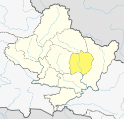 Location of Lamjung (dark yellow) in Gandaki Pradesh | |
| Country | |
| Province | Gandaki Pradesh |
| Admin HQ. | Besisahar |
| Government | |
| • Type | Coordination committee |
| • Body | DCC, Lamjung |
| Area | |
| • Total | 1,692 km2 (653 sq mi) |
| Population (2011)[1] | |
| • Total | 167,724 |
| • Density | 99/km2 (260/sq mi) |
| Time zone | UTC+05:45 (NPT) |
| Telephone Code | 066 |
| Main Language(s) | Nepali, Gurung, Magar, Dura |
| Website | Official website |
Gallery
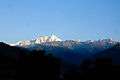 Annapurna II
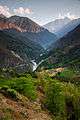 River Marshyangdi
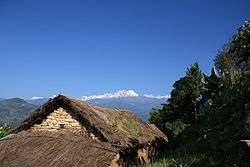
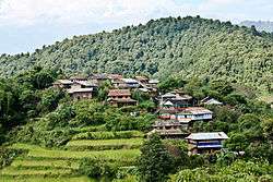 Hiletaksar Village
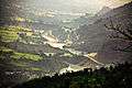 70 MW Middle Marshyangdi Hydro-power Dam (view from Gaunshahar)
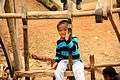 A Gurung child playing on a traditional Nepalese wooden rotatory swing
Geography and climate
| Climate Zone[2] | Elevation Range | % of Area |
|---|---|---|
| Upper Tropical | 300 to 1,000 meters 1,000 to 3,300 ft. |
18.5% |
| Subtropical | 1,000 to 2,000 meters 3,300 to 6,600 ft. |
34.0% |
| Temperate | 2,000 to 3,000 meters 6,400 to 9,800 ft. |
20.3% |
| Subalpine | 3,000 to 4,000 meters 9,800 to 13,100 ft. |
14.1% |
| Alpine | 4,000 to 5,000 meters 13,100 to 16,400 ft. |
8.0% |
| Nival | above 5,000 meters | 3.6% |
| Trans-Himalayan | 3,000 to 6,400 meters 9,800 to 21,000 ft. |
1.3% |
Demographics
At the time of the 2011 Nepal census, Lamjung District had a population of 167,724. Of these, 58.6% spoke Nepali, 29.8% Gurung, 6.6% Tamang, 1.8% Newari, 1.0% Dura and 0.9% Magar as their first language.
38.7% of the population in the district spoke Nepali and 1.3% Gurung as their second language.[3]
Rural municipalities and municipalities
2015 earthquake
The epicentre of an earthquake on 25 April 2015 was near Lamjung District.[4] Most of the major damage and casualties took place in nearby Kathmandu, Nepal's capital.[5] The death toll was placed at over 8,800. However, only four deaths were reported in Lamjung District.
While Lamjung was the district with the 20th most deaths in Nepal, it was severely damaged. The villages of Bichaur, Ilampokhari, Dudhpokhari, Gauda, Kolki and Pyarjung were the most affected. Assistant Sub Inspector Bir Bahadur Thapa Magar identified the four deaths in Lamjung District as Lakshmi Gurung, 18, of Ilampokhari village; Nepti Tamang, 91, of Gaudu village; Sher Bahadur Tamang, 62, of Gaudu village; and three-and-a-half month old Sumit Bika of Gauda village. Twenty-five people were injured in Lamjung District. Local police estimate 2,094 houses were completely destroyed while another 2,129 houses were partially damaged.[6]
References
- "National Population and Housing Census 2011(National Report)" (PDF). Central Bureau of Statistics. Government of Nepal. November 2012. Archived from the original (PDF) on 2013-04-18. Retrieved 19 June 2015.
- The Map of Potential Vegetation of Nepal — a forestry/agroecological/biodiversity classification system (PDF), Forest & Landscape Development and Environment Series 2-2005 and CFC-TIS Document Series No.110., 2005, ISBN 87-7903-210-9, retrieved Nov 22, 2013
- 2011 Nepal Census, Social Characteristics Tables
- "Map of the earthquake M7.9 - 29km ESE of Lamjung, Nepal". Global Earthquake Epicenters with Maps. Geographic.org. Retrieved 25 April 2015.
- "Strong Earthquake Strikes Nepal Near Its Capital, Katmandu". The New York Times. Retrieved 25 April 2015.
- Khan, Hamza (1 May 2015). "Nepal Earthquake: Death toll crosses 5,000, but only 4 die at epicentre". The Indian Express. The Indian Express. Archived from the original on 1 May 2015. Retrieved 1 May 2015.
- "Districts of Nepal". Statoids.
| Wikimedia Commons has media related to Lamjung District. |
Headquarters: Besisahar Municipality | ||
| Municipalities | 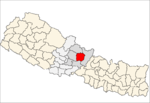 | |
| Rural municipalities | ||
| Former VDCs |
| |