Severo-Kurilsky District
Severo-Kurilsky District (Russian: Се́веро-Кури́льский райо́н) is an administrative district (raion) of Sakhalin Oblast, Russia; one of the seventeen in the oblast.[1] Municipally, it is incorporated as Severo-Kurilsky Urban Okrug.[5] It is located on the northern Kuril Islands to the east of the Island of Sakhalin and immediately southwest of the Kamchatka Peninsula. The area of the district is 3,501.2 square kilometers (1,351.8 sq mi).[7] Its administrative center is the town of Severo-Kurilsk on Paramushir island.[1] Population: 2,536 (2010 Census);[3] 2,592 (2002 Census);[8] 5,420 (1989 Census).[9] The population of Severo-Kurilsk accounts for almost 100% of the district's total population,[3][10] though there is often a seasonal population on the island of Shumshu.
Severo-Kurilsky District Северо-Курильский район | |
|---|---|
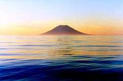 Atlasov Island, Severo-Kurilsky District | |
.png) Flag .png) Coat of arms | |

Location of Severo-Kurilsky District in Sakhalin Oblast | |
| Coordinates: 50°41′N 156°07′E | |
| Country | Russia |
| Federal subject | Sakhalin Oblast[1] |
| Established | 5 June 1946 |
| Administrative center | Severo-Kurilsk[1] |
| Area | |
| • Total | 3,501.2 km2 (1,351.8 sq mi) |
| Population | |
| • Total | 2,536 |
| • Estimate (2018)[4] | 2,507 (-1.1%) |
| • Density | 0.72/km2 (1.9/sq mi) |
| • Urban | 100% |
| • Rural | 0% |
| Administrative structure | |
| • Inhabited localities | 1 Cities/towns, 1 Rural localities |
| Municipal structure | |
| • Municipally incorporated as | Severo-Kurilsky Urban Okrug[5] |
| Time zone | UTC+11 (MSK+8 |
| OKTMO ID | 64743000 |
| Website | http://sevkur.admsakhalin.ru/ |
Islands
The district includes the following islands from north to south:
| Island | Russian: Name | Japanese: Name | Alternative names | Capital / Landing point | Other Cities | Area (km2) | Population |
|---|---|---|---|---|---|---|---|
| Severo-Kurilsky District | North Kurils (Kita-chishima / 北千島) | Severo-Kurilsk | Shelikovo, Podgorny, Baikovo | 3,504.00 | 2,560 | ||
| Shumshu | Шумшу | 占守島 | Shumushu | Baikovo | 388.0 | 20 | |
| Atlasov | Атласова | Araido / 阿頼度島 | Oyakoba | Alaidskaya Bay | 150.0 | 0 | |
| Awos | Avos | 0.1 | 0 | ||||
| Paramushir | Парамушир | 幌筵島 | Paramushiro | Severo-Kurilsk | Shelikovo, Podgorny | 2,053.0 | 2,540 |
| Antsiferov | Анциферова | 志林規島 | Shirinki | Antsiferov beach | Cape Terkut | 7.0 | 0 |
| Makanrushi | Маканруши | 磨勘留島 | Makanru | Zakat | 50.0 | 0 | |
| Onekotan | Онекотан | 温禰古丹島 | Mussel | Kuroisi, Nemo, Shestakov | 425.0 | 0 | |
| Kharimkotan | Харимкотан | 春牟古丹島 | Harimukotan, Harumukotan | Sunazhma | Severgin Bay | 70.0 | 0 |
| Ekarma | Экарма | 越渇磨島 | Ekaruma | Kruglyy | 30.0 | 0 | |
| Chirinkotan | Чиринкотан | 知林古丹島 | Cape Ptichy | 6.0 | 0 | ||
| Shiashkotan | Шиашкотан | 捨子古丹島 | Shasukotan | Makarovka | 122.0 | 0 | |
| Raikoke | Райкоке | 雷公計島 | Raikoke | 4.6 | 0 | ||
| Matua | Матуа | 松輪島 | Matsuwa, Matsua | Sarychevo | 52.0 | 0 | |
| Rasshua | Расшуа | 羅処和島 | Rasutsuwa, Rashowa | Arches Point | 67.0 | 0 | |
| Ushishir | Ушишир | 宇志知島 | Ushishiru | Kraternya | Ryponkicha | 5.0 | 0 |
| Ketoy | Кетой | 計吐夷島 | Ketoi | Storozheva | 73.0 | 0 | |
| Other | Toporkova | Ostrov Srednego, Lowuschki Rock | 1.3 | 0 | |||
References
Notes
- Law #25-ZO
- http://www.gks.ru/dbscripts/munst/munst64/DBInet.cgi?pl=8006001.
- Russian Federal State Statistics Service (2011). "Всероссийская перепись населения 2010 года. Том 1" [2010 All-Russian Population Census, vol. 1]. Всероссийская перепись населения 2010 года [2010 All-Russia Population Census] (in Russian). Federal State Statistics Service.
- "26. Численность постоянного населения Российской Федерации по муниципальным образованиям на 1 января 2018 года". Federal State Statistics Service. Retrieved January 23, 2019.
- Law #524
- "Об исчислении времени". Официальный интернет-портал правовой информации (in Russian). June 3, 2011. Retrieved January 19, 2019.
- "General Information" (in Russian). Severo-Kurilsky District. Retrieved August 31, 2016.
- Russian Federal State Statistics Service (May 21, 2004). "Численность населения России, субъектов Российской Федерации в составе федеральных округов, районов, городских поселений, сельских населённых пунктов – районных центров и сельских населённых пунктов с населением 3 тысячи и более человек" [Population of Russia, Its Federal Districts, Federal Subjects, Districts, Urban Localities, Rural Localities—Administrative Centers, and Rural Localities with Population of Over 3,000] (XLS). Всероссийская перепись населения 2002 года [All-Russia Population Census of 2002] (in Russian).
- "Всесоюзная перепись населения 1989 г. Численность наличного населения союзных и автономных республик, автономных областей и округов, краёв, областей, районов, городских поселений и сёл-райцентров" [All Union Population Census of 1989: Present Population of Union and Autonomous Republics, Autonomous Oblasts and Okrugs, Krais, Oblasts, Districts, Urban Settlements, and Villages Serving as District Administrative Centers]. Всесоюзная перепись населения 1989 года [All-Union Population Census of 1989] (in Russian). Институт демографии Национального исследовательского университета: Высшая школа экономики [Institute of Demography at the National Research University: Higher School of Economics]. 1989 – via Demoscope Weekly.
- No population was reported during the 2010 Census for the only rural locality in the district.
Sources
- Сахалинская областная Дума. Закон №25-ЗО от 23 марта 2011 г. «Об административно-территориальном устройстве Сахалинской области», в ред. Закона №62-ЗО от 27 июня 2013 г. «О внесении изменения в статью 10 Закона Сахалинской области "Об административно-территориальном устройстве Сахалинской области"». Вступил в силу 9 апреля 2011 г.. Опубликован: "Губернские ведомости", №55(3742), 29 марта 2011 г. (Sakhalin Oblast Duma. Law #25-ZO of March 23, 2011 On the Administrative-Territorial Structure of Sakhalin Oblast, as amended by the Law #62-ZO of June 27, 2013 On Amending Article 10 of the Law of Sakhalin Oblast "On the Administrative-Territorial Structure of Sakhalin Oblast". Effective as of April 9, 2011.).
- Сахалинская областная Дума. Закон №524 от 21 июля 2004 г. «О границах и статусе муниципальных образований в Сахалинской области», в ред. Закона №45-ЗО от 27 мая 2013 г. «О внесении изменения в Закон Сахалинской области "О границах и статусе муниципальных образований в Сахалинской области"». Вступил в силу 1 января 2005 г. Опубликован: "Губернские ведомости", №175–176(2111–2112), 31 июля 2004 г. (Sakhalin Oblast Duma. Law #524 of July 21, 2004 On the Borders and Status of the Municipal Formations in Sakhalin Oblast, as amended by the Law #45-ZO of May 27, 2013 On Amending the Law of Sakhalin Oblast "On the Borders and Status of the Municipal Formations in Sakhalin Oblast". Effective as of January 1, 2005.).
Places adjacent to Severo-Kurilsky District | ||||||||||
|---|---|---|---|---|---|---|---|---|---|---|
| ||||||||||
Administrative center: Yuzhno-Sakhalinsk • Rural localities | |||
| Administrative districts | |||
| Cities and towns | |||
| Urban-type settlements | |||