Shymkent
Shymkent (Kazakh: Shymkent, Шымкент, شىمكەنت; Yañalif: Şьmkent; Kazakh pronunciation: [ʃɯmˈkɛnt]), known until 1993 as Chimkent[2] (Uzbek: Chimkent, Чимкент, چىمكېنت; Yañalif: Çimkent (Uzbek pronunciation: [tʃɨmˈkɛnt])); Russian: Чимкент, romanized: Čimkent (Russian pronunciation: [ˈtɕɨmˈkʲɛnt])), is a city in Kazakhstan. It is near the border with Uzbekistan. It is one of three Kazakh cities which have the status equal to that of a region (the city of republican significance[3]). It is the third most populous city in Kazakhstan, behind Almaty and Nur-Sultan, with an estimated population of 1,002,291 as of June 1, 2018.[4]. According to regional and city officials, the millionth resident of Shymkent was born on 17 May 2018.[5] It is a regional cultural centre.
Shymkent Shymkent Шымкент شىمكەنت | |
|---|---|
.jpg)  Montage of Shymkent | |
 Shymkent Location in Kazakhstan | |
| Coordinates: 42°19′0″N 69°35′45″E | |
| Country | Kazakhstan |
| Founded | 12th century |
| Government | |
| • Akim | Erlan Aytakhanov |
| Area | |
| • Total | 1,162.8 km2 (449.0 sq mi) |
| Elevation | 506 m (1,660 ft) |
| Population (1 March 2020) | |
| • Total | 1,042,218[1] |
| Time zone | UTC+6 (BTT) |
| Postal code | 160000 |
| Area code(s) | (+7) 7252 |
| Vehicle registration | 17 |
| Website | shymkent |
Shymkent is situated 690 kilometres (430 mi) west of Almaty and 1,483 kilometres (920 mi) south of Nur-Sultan. It is also 120 kilometres (75 mi) to the north of Tashkent, Uzbekistan.
Etymology
The name Chimkent comes from two Sogdian words, chim (meaning 'turf') and kent (or kand) (meaning 'city') (also found in the name of nearby Toshkent); thus, it literally means "the city in the grass/turf."
After Kazakhstan gained independence, the city was renamed Shymkent in 1993 as part of the government's campaign to apply Kazakh names to cities. The formal spelling of Shymkent, as codified in Kazakhstan's Constitution, goes against the original Uzbek spelling rules of never having the letter "ы" follow the letter "ш". (Uzbek itself has no letter ы. Furthermore, what is spelled as ш in Kazakh is spelled as ч in Uzbek.) As a result, the new name Шымкент (Shymkent) is used only in Kazakhstan, while other countries continue to use the original spelling Чимкент (Chimkent/Čimkent).
History
Shymkent was founded in the twelfth century[6] as a caravanserai to protect a nearby Silk Road trade town, Sayram, 10 km to the east. Shymkent grew as a market center for trade between Turkic nomads and the settled Sogdians. It was destroyed several times: by Genghis Khan, soldiers from the southern Khanates, and by nomad attacks. In the early 19th century, it became part of the khanate of Kokand before it was captured by the Russians in 1864.[7] It was renamed Chernyaev in 1914 and renamed Shymkent in 1924. Following the Russian conquest, Shymkent was a city of trade between nomadic Turks and sedentary Turks, and was famous for its kumis.[8]
A settlement on the territory of modern Shymkent already existed at the turn of the 11th – 12th centuries. At the same time, there is a hypothesis about its earlier establishment based on the burials found during the archaeological excavations, which, according to experts, date back to the 5th – 6th centuries. In the sources that have reached our time, the Central Asian historian Sharaf ad-din Yazdi (1425) first mentioned Shymkent in the book Zafar Name (Book of Victories), when describing the military campaigns of Timur.
Chimkent (Shymkent), as a city-settlement already existed in the 6th century AD. Its name links to the famous traveler Xuan Jiang, who mentioned it in his notes about Isfijab - Sairam.
It is widely believed that the city existed in the 12th century. This information is taken from the book of A. Dobrosmyslov “Cities of the Syr-Darya region”, where he reports the following: “The name of the city of Chimkent comes from the words chim - sod and kent - city. Indigenous people of Chimkent relate the time of its establishment to the 12th century, referring to the grave of St. Baba Dervish, a contemporary of Khoja Ahmet Yasawi.”
In 1914, in honour of the 50th anniversary of Shymkent becoming part of the Russian Empire, the city was named Chernyaev, but in 1924 the Soviet authorities returned to the city its former name.
A lead plant was built in Shymkent in the 1930s. It accounted for 70% of the total lead produced in the Soviet Union. An oil and fat plant, a hosiery and a mirror factory were commissioned. In 1932, an agricultural aviation base was created, which led to the creation and development of the city airport.
During the Second World War, a number of Soviet industrial enterprises were evacuated in Shymkent. From the front line, 17 plants and factories were relocated here. The city produced spare parts for tanks, shells, metal, lead for bullets, optical instruments and other products. Seven Shymkent residents were awarded the title of the Hero of the Soviet Union.
There was a gulag near Shymkent, and as a result, many Russian-speaking people came to the area through imprisonment in that gulag.[9]
In January 2015, Shymkent officials sent a request to UNESCO to be recognized as an ancient city.[10]
Until 2018, Shymkent was the administrative center of South Kazakhstan Region. On June 19, 2018, it was taken out of South Kazakhstan Region and subordinated directly to the government of Kazakhstan. As a result, the administrative center of the region is moved to Turkistan, and the region was renamed as Turkistan Region.[11]
Geography
Climate
Shymkent features a continental mediterranean climate (Köppen Dsa) that borders on a mediterranean climate (Csa). Shymkent features hot, relatively dry summers and cold winters. Winters here are noticeably warmer than in more northerly cities like Almaty and Nursultan, with the mean monthly temperature during the city's coldest month (January) averaging around −1 °C (30.2 °F). Winter snowfalls are common, although rainfall during that season occurs mixed in with that. Shymkent averages just under 600 millimetres (23.62 in) of precipitation annually.
| Climate data for Shymkent (1981–2010) | |||||||||||||
|---|---|---|---|---|---|---|---|---|---|---|---|---|---|
| Month | Jan | Feb | Mar | Apr | May | Jun | Jul | Aug | Sep | Oct | Nov | Dec | Year |
| Record high °C (°F) | 22.2 (72.0) |
25.2 (77.4) |
30.7 (87.3) |
33.0 (91.4) |
37.8 (100.0) |
43.0 (109.4) |
42.6 (108.7) |
42.2 (108.0) |
39.2 (102.6) |
34.4 (93.9) |
30.5 (86.9) |
25.4 (77.7) |
43.0 (109.4) |
| Average high °C (°F) | 4.1 (39.4) |
6.6 (43.9) |
12.9 (55.2) |
19.2 (66.6) |
25.1 (77.2) |
30.0 (86.0) |
32.7 (90.9) |
32.1 (89.8) |
27.2 (81.0) |
18.8 (65.8) |
12.1 (53.8) |
6.0 (42.8) |
18.9 (66.0) |
| Daily mean °C (°F) | −0.7 (30.7) |
1.6 (34.9) |
7.6 (45.7) |
13.6 (56.5) |
19.1 (66.4) |
23.7 (74.7) |
26.3 (79.3) |
25.3 (77.5) |
19.9 (67.8) |
12.3 (54.1) |
6.4 (43.5) |
0.9 (33.6) |
13.0 (55.4) |
| Average low °C (°F) | −4.8 (23.4) |
−2.7 (27.1) |
3.0 (37.4) |
8.3 (46.9) |
12.9 (55.2) |
16.7 (62.1) |
19.1 (66.4) |
17.9 (64.2) |
12.8 (55.0) |
6.6 (43.9) |
1.7 (35.1) |
−3.1 (26.4) |
7.4 (45.3) |
| Record low °C (°F) | −31.1 (−24.0) |
−28.9 (−20.0) |
−23.9 (−11.0) |
−5.0 (23.0) |
−2.8 (27.0) |
5.5 (41.9) |
7.8 (46.0) |
6.2 (43.2) |
−1.1 (30.0) |
−12.0 (10.4) |
−30.0 (−22.0) |
−26.1 (−15.0) |
−31.1 (−24.0) |
| Average precipitation mm (inches) | 73 (2.9) |
70 (2.8) |
83 (3.3) |
69 (2.7) |
56 (2.2) |
16 (0.6) |
12 (0.5) |
4 (0.2) |
10 (0.4) |
41 (1.6) |
67 (2.6) |
75 (3.0) |
576 (22.7) |
| Average rainy days | 5 | 7 | 9 | 9 | 9 | 5 | 4 | 3 | 3 | 6 | 6 | 6 | 72 |
| Average snowy days | 8 | 7 | 4 | 0.3 | 0 | 0 | 0 | 0 | 0 | 0.4 | 3 | 6 | 29 |
| Average relative humidity (%) | 75 | 73 | 67 | 63 | 56 | 44 | 39 | 34 | 39 | 55 | 69 | 75 | 57 |
| Source: Pogoda.ru.net[12] | |||||||||||||
Vegetation
The vegetation[13] of the city is known by its extreme diversity. Trees like oak, elm, poplar, cannan maple, willow, chestnut, acacia, ailanthus, thuja, pine, spruce grow in the city. Form horticultural crops cherry, apricot, dried apricot, plum, pomegranate, walnut, quince, grape varieties are widespread. On the north of the city, in 1980, "Dendropark" was built. Its area is 150 ha and there are about half of million trees and shrubs of 1360 different types. Most of them are rare and exotic types.
Demographics
As of 2012, Shymkent's population consists of:
- Kazakhs 64.76%
- Russians 14.52%
- Uzbeks 13.7%
- Tatars 1.54%
- Others 5.48% (Ukrainians 0.54%, Koreans 1%)[14]
According to a government estimate in 2012, the city had 669,326 inhabitants.[15] In 2009, the population of Shymkent was 603,499 (2009 Census results);[16] in 1999, it was 423,902 (1999 Census results).[16] By the beginning of 2015, Shymkent was joined by the areas of adjacent districts. In this connection, the city population has increased up to 858,147 people within the new boundaries by the beginning of 2015.[17] By that time, 711,783 people resided in the former area of Shymkent [18]. By 1 June 2018, the population of Shymkent was 1,002,291.[4]
The following tables are the total population of Shymkent since 1897:
| 1897 | 1908 | 1913 | 1939 | 1959 | 1970 | 1977 | 1979 | 1989 | 1992 |
|---|---|---|---|---|---|---|---|---|---|
| 11 194 | 17 000 | 19 000 | 74 000 | 153 000 | 247 000 | 303 000 | 321 535 | 392 977 | 405 500 |
| 1993 | 1994 | 1995 | 1996 | 1997 | 1998 | 1999 | 2000 | 2001 | 2002 |
|---|---|---|---|---|---|---|---|---|---|
| 409 700 | 411 400 | 414 400 | 417 900 | 417 400 | 419 700 | 435 300 | 482 900 | 502 700 | 506 700 |
| 2003 | 2004 | 2005 | 2006 | 2007 | 2008 | 2009 | 2010 | 2011 | 2012 |
|---|---|---|---|---|---|---|---|---|---|
| 513 100 | 521 200 | 526 100 | 535 100 | 554 600 | 602 300 | 615 000 | 629 100 | 642 600 | 662 300 |
| 2013 | 2015 | 2016 | 2018 |
|---|---|---|---|
| 683 300 | 858 147 | 885 799 | 1 002 291 |
Status of a city of republican significance
On June 19, 2018, by the decree of the President of Kazakhstan, Shymkent was given the status of a city of republican significance. It was removed from the South Kazakhstan region, which was renamed Turkestan by the same decree. The city of Shymkent became an independent administrative-territorial unit, equal to the region, and a 17th region was established in Kazakhstan.
Economy
Formerly dominated by lead mining, industrial growth began in the 1930s.
A lead smelter was opened in Shymkent in 1934[19] or 1938.[20] It supplied a major part of the USSR's metals needs, copper as well as lead and others, including three-quarters of all bullets fired by the Red Army. Smelting continued until 2008, causing extreme levels of pollution (lead, cadmium, etc.) in the surrounding ground, and then controversially restarted in 2010, briefly, under a major UK-listed company, Kazakhmys.[19]
The city also has industries producing refined zinc, processed karakul pelts, textiles, foodstuffs, and pharmaceuticals. Also, the city has a medium-sized refinery, which is owned and operated by PetroKazakhstan.
Shymkent is one of the leading industrial and economic centres of Kazakhstan. The city has industrial enterprises of non-ferrous metallurgy, mechanical engineering, chemical, oil refining and food industries.
The petrochemical and pharmaceutical industries include “PetroKazakhstan Oil Products” LLP (oil refining), “Khimpharm” JSC (medicines). Metallurgical goods are produced by “Yuzhpolymetal” JSC (lead and other products).
Mechanical engineering is represented by Cardanval JSC (cardan shafts and crosspieces for cars and tractors), Yuzhmash JSC (forging and pressing machines, spare parts and equipment), Elektroapparat LLP (power switches and other products).
As for light industry, enterprises include “Voskhod” (garments from woolen and semi-woolen fabrics: suits, coats, jackets, etc.), “Adal” (textile), “Elastic” (socks from high-quality yarn). Construction materials are produced by “Shymkentcement” and “Kurylys materialdary” JSC (bricks).
“Shymkentmai” JSC and “Kainar” LLP (processing of cotton, sunflower, safflower, soybean, production of refined edible oil and other products), “Shymkentpivo” JSC (beer), “Visit” JSC (soft drinks), “Shymkentsut” JSC (dairy products) are also operating in the city.
Industrial production increased by 15% compared to 2018.
Agricultural production increased by 6.3%, housing construction - by 19.2%, retail trade - by 7.1%.
In the last 3 years, as part of the Industrial and Innovative Development Programme, 24 enterprises were opened in Shymkent, and 1,300 permanent jobs were created.
There are 2 industrial zones in the city. To date, investments worth 64 billion tenge have been attracted, 72 projects have been launched, more than 4,000 people have been employed.
Culture
Shymkent has throughout its 2200-year history been under many different cultural influences of its controlling civilizations.[21] Shymkent serves as the Cultural Capital of the Commonwealth of Independent States in 2020.[22]
Transportation
A bicycle-sharing system operates in Shymkent with 40 stations around the city.[23] The city is a major railroad junction in the Turkestan-Siberia Railway. Shymkent International Airport is responsible for air traffic in this city.
Major roads passing through Shymkent include M32 and A2.
Sightseeing
Streets
Before 1864, the city consisted of a chaotic interweaving of winding streets around the citadel of the ancient city of Shymkent (the so-called “Old City”). But after it became a town of the Syrdarya region in 1867, the “New City” gradually emerged - an area that has a rectangular-quarter street layout. It was limited to Nikolaevskaya (now Kazybek-bi), Stepnaya (Kunaev Boulevard), Sadovaya (Tauke Khan Avenue) and Meshchanskaya (now Turkestan) streets. Currently, there are 1964 streets in the city, the total length of all streets and roads is 2135 km.
Parks
The Ken Baba street
This park (formerly the Cathedral Garden, Nikolsky Church Park, Children’s Park) is one of the oldest in the city, located on Kazybek bi street at the intersection with Tauke Khan Avenue. In 1908, St. Nicholas Cathedral was built in the area by the architect Matsevich, which opened in the autumn of 1914. This three-story building is considered one of the best examples of religious construction in the "red brick style." In the Soviet years, it was transformed into a regional library, and later into the Palace of Pioneers. Now it is the Regional Puppet Theatre.
Valuable trees (mainly oaks), planted here in the late 19th and early 20th centuries, still grow in the park. Currently, there are numerous children's attractions, catering establishments. The water of the spring source is sent to artificial waterfalls that flow into decorative ponds, then the water is redistributed through the channels. Waterfowl (swans, ducks, etc.), as well as decorative fish can be spotted in the water.
Central park
This park (formerly the Public City Garden) is also located on Kazybek Bi Street near Ken Baba Park. It was built at the end of the 19th century, almost simultaneously with the Cathedral Garden.
The old city
The old city began to appear thanks to artisans and farmers who began to settle at the foot of the citadel of the ancient city of Shymkent in the 16th century.
Today, the streets of the Old City follow the outlines of the streets of past centuries. But only two architectural objects of the century before last have survived - the Koshkar Ata mosque and the house of the district chief. In the late period of the Soviet Union, a plan was created to preserve the Old Town as an open-air museum with special requirements for newly erected buildings to combine the historical and modern architectural style.
The Ordabasy Square
In the 19th century, the eastern border of the city passed here, and there were also fortified gates leading to Sairam and Taraz. In those days, there was a bazaar nearby, therefore this square was called "Bazaar"; the street got the same name, which originated from this square.
Currently, three streets converge on the Ordabasy Square, named after renowned Kazakh people - Tole bi, Kazybek bi, Aiteke bi. The monument “Otan Ana” was erected right in the center of the square. It has three faces with a height of 34 meters. Famous sayings of the three renowned people are carved on each face of the monument. The top of the monument is crowned by the figure of a young woman who releases seven swallows into the sky.
Under the square flows the river Koshkar Ata; it contains fountain complexes in close proximity to the monument.
The Ordabasy Square connects to the Independence Park through a 104-meter-long bridge.
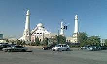
The Koshkar Ata mosque
The mosque was built in 1850-1856. It was erected by Ferghana masters in the style of quarterly mosques of frontal composition. Initially, the building was built of mud brick, but due to flooding by the river, it collapsed over time. Therefore, in 1891-1893 the mosque was rebuilt from burnt brick. The main facade was made in the form of a three-arch structure, the building had a right and left wing. In 2009, the left wing was destroyed despite the fact that the mosque is protected by law as a monument of architecture.
Sport
- FC Ordabasy - Men's football team (Current playing in Kazakhstan Premier League)
- BIIK Kazygurt - Women's football team
Kazhymukan Munaitpasov Stadium is the main stadium in the city. Its capacity is 20,000. It is the base of FC Ordabasy.
Twin cities
Twin Cities is the name of the sister cities program.[24]
| City | Country | Year |
|---|---|---|
| Mogilev | ||
| Stevenage | 1990 | |
| Acharnon | Greece | |
| İzmir | 2004 | |
| Pattaya | 2017 | |
| Grosseto | ||
| Baiyin | China | |
| Khujand | ||
| Eskishehir[25] |
Gallery
 View of the central part of the city from Independence Park
 Shopping Mall "Mega Center Shymkent"
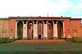 Palace of Metallurgists
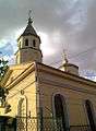 Temple of the Icon of Kazan Mother of God
.jpg) Turkestan st. (улица Туркестанская)
Turkestan st. (улица Туркестанская) French house
 House on Tauke Khan Avenue after restoration
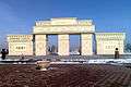 Arch at Independence Park
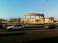 Arcade in Shymkent Square
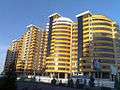 Residential complex «Kazakhstan» on Kunayev Boulevard
 Residential buildings on Kunaev Boulevard
 View of the crossroads of Tauke-khan Avenue and Kunaev Bulevard from "Mega Center Shymkent" shopping mall
 View on shopping mall in Shymkent, called ЦУМ in the Russian/Soviet style
 Fountains near the Central Department store (ЦУМ)
 Al-Farabi st., the view of the local Medical Academy
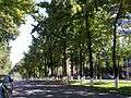 Turkestan st. (улица Туркестанская)
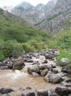 Mountains on the outskirts of Shymkent
References
- https://www.stat.gov.kz/official/industry/61/statistic/6
- Chisholm, Hugh, ed. (1911). . Encyclopædia Britannica. 6 (11th ed.). Cambridge University Press. p. 165.
- Nurlan Sauranbayev. "Congratulation of Shymkent city akim N. Sauranbayev with the acquisition the city of republican significance". Archived from the original on 22 June 2018. Retrieved 22 June 2018.
- Об изменении численности населения Республики Казахстан с начала 2018 года до 1 июня 2018 года
- Shymkent's Akimat. "A millionth resident of Shymkent received an apartment as a gift". Archived from the original on 13 June 2018.
- Peoples of central Asia. By Lawrence Krader. Published by Indiana University, 1971
- http://www.britannica.com/EBchecked/topic/111610/Shymkent
- Through Russian central Asia. By Stephen Graham. Published by The Macmillan Company, 1916
- The Gulag Archipelago, 1918–1956: an experiment in literary investigation. By Aleksandr I. Solzhenitsyn, H. T. Willetts, Thomas P. Whitney. Published by Westview Press, 1997
- "Shymkent Seeks UNESCO Recognition As 2,200-Year-Old City". www.astanatimes.com.
- "Публичное подписание Указа «О некоторых вопросах административно-территориального устройства Республики Казахстан»" (in Russian). President of Kazakhstan. 19 June 2018. Retrieved 21 June 2018.
- "Weather and Climate - The Climate of Shymkent" (in Russian). Weather and Climate (Погода и климат). Archived from the original on 25 November 2016. Retrieved 25 November 2016.
- https://ru.wikipedia.org/wiki/%D0%A8%D1%8B%D0%BC%D0%BA%D0%B5%D0%BD%D1%82#%D0%A0%D0%B0%D1%81%D1%82%D0%B8%D1%82%D0%B5%D0%BB%D1%8C%D0%BD%D0%BE%D1%81%D1%82%D1%8C
- www.stat.kz Archived 2012-11-16 at the Wayback Machine
- "List of Localities with Population - Akimat of the South Kazakhstan Region". ontustik.gov.kz. 29 September 2015.
- "Население Республики Казахстан" (in Russian). Департамент социальной и демографической статистики. Retrieved 8 December 2013.
- Численность населения Республики Казахстан по областям, городам и районам на начало 2015 года
- Численность населения Республики Казахстан по областям, городам и районам на 1 января 2015 года
- People & Power (TV programme), Al Jazeeera English, Robin Forestier, 20 February 2014
- The USSR. By John C. Dewdney. Published by Dawson, 1976
- "Shymkent Seeks UNESCO Recognition As 2,200-Year-Old City". The Astana Times.
- "Kazakhstan's Shymkent takes over as CIS Capital of Culture". KazInform.
- Shymkent Bike
- "Shymkent Mayor".
- "اتفاقية توأمة بين الغردقة وإقليم جنوب كازاخستان لتنشيط السياحة |صور". بوابة الأهرام (in Arabic). Retrieved 14 July 2018.
External links
| Wikimedia Commons has media related to Shymkent. |
| Wikivoyage has a travel guide for Shymkent. |
| Regions |  | |
|---|---|---|
| Special status cities | ||
| Capital | | |
|---|---|---|
| Other cities | ||
| Authority control |
|
|---|