List of U.S. states and territories by elevation
The elevation of the U.S. states, the federal district, and the territories may be described in several ways. These include:
- the elevation of their highest point;
- the elevation of their lowest point; and
- the difference between (range of) their highest points and lowest points.
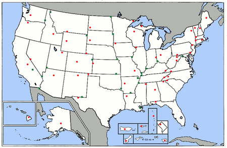
The following list is a comparison of elevation absolutes in the United States. Data include interval measures of highest and lowest elevation for all 50 states, the District of Columbia, and territories.[1]
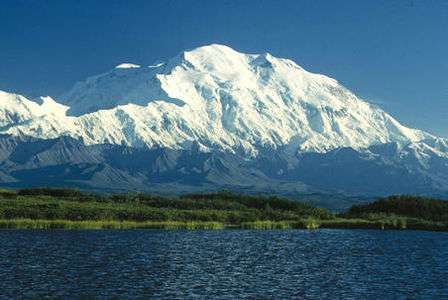
Which state or territory is "highest" and "lowest" is determined by the definition of "high" and "low". For instance, Alaska could be regarded as the highest state because Denali, at 20,310 feet (6,190.5 m), is the highest point in the United States. However, Colorado, with the highest mean elevation of any state as well as the highest low point, could also be considered a candidate for "highest state". Determining which state is "lowest" is equally problematic. California contains the Badwater Basin in Death Valley, at 279 feet (85 m) below sea level, the lowest point in the United States;[2] while Florida has the lowest high point, and Delaware has the lowest mean elevation. Florida is also the flattest state, with the smallest difference between its highest and lowest points.
The list of highest points in each state is important to the sport of highpointing, where enthusiasts attempt to visit the highest point in each of the contiguous 48 states, or in all 50 states, or in all 50 states plus the District of Columbia and the territories.[3] As of 2006, 155 people had reached the fifty state highpoints.[4] Roughly 200–300 people attend the Highpointers Club convention each year.[5]
All elevations in the table below have been adjusted to the North American Vertical Datum of 1988.[6] The mean elevation for each state, the District of Columbia and Puerto Rico is accurate to the nearest 100 ft (30 m). Mean elevation data is unavailable for the other U.S. territories.
Elevation table
| State federal district or territory |
Highest point | Highest elevation | Rank (High point) | Lowest point | Lowest elevation | Mean elevation | Elevation span |
|---|---|---|---|---|---|---|---|
| Cheaha Mountain[9] | 2,413 ft 736 m |
38 | Gulf of Mexico | sea level | 500 ft 150 m |
2,413 ft 736 m | |
| Denali[10] | 20,310 ft 6190.5 m |
1 | Gulf of Alaska, Bering Sea, and Arctic Ocean | sea level | 1,900 ft 580 m |
20,310 ft 6190.5 m | |
| Lata Mountain on Ta‘ū island[11] | 3,163 ft 964 m |
36 | Pacific Ocean | sea level | NA | 3,163 ft 964 m | |
| Humphreys Peak[12] | 12,637 ft 3852 m |
12 | Colorado River at Sonora border, San Luis, Arizona | 72 ft 22 m |
4,100 ft 1250 m |
12,565 ft 3830 m | |
| Mount Magazine[13] | 2,753 ft 839 m |
37 | Ouachita River at Louisiana border | 55 ft 17 m |
650 ft 200 m |
2,698 ft 822 m | |
| Mount Whitney[14][15] | 14,505 ft 4421.0 m |
2 | Badwater Basin in Death Valley[1][2][16] | −279 ft −85 m |
2,900 ft 880 m |
14,783 ft 4506 m | |
| Mount Elbert[17][18] | 14,440 ft 4401.2 m |
3 | Arikaree River at Kansas border[19][20] | 3,317 ft 1011 m |
6,800 ft 2070 m |
11,123 ft 3390 m | |
| Massachusetts border on the southern slope of Mount Frissell[lower-alpha 1] | 2,379 ft 725 m |
39 | Long Island Sound | sea level | 500 ft 150 m |
2,379 ft 725 m | |
| Near the Ebright Azimuth[22][23] | 447 ft 136 m |
54 | Atlantic Ocean | sea level | 60 ft 20 m |
447 ft 136 m | |
| Fort Reno[24] | 409 ft 125 m |
55 | Potomac River at eastern Maryland border | 1.0 ft 0.3 m |
150 ft 50 m |
408 ft 124 m | |
| Britton Hill | 345 ft 105 m |
56 | Atlantic Ocean and Gulf of Mexico | sea level | 100 ft 30 m |
345 ft 105 m | |
| Brasstown Bald | 4,784 ft 1458 m |
25 | Atlantic Ocean | sea level | 600 ft 180 m |
4,784 ft 1458 m | |
| Mount Lamlam | 1,332 ft 406 m[25] |
48 | Pacific Ocean | sea level | NA | 1,332 ft 406 m | |
| Mauna Kea[26][27] on the Island of Hawai'i | 13,803 ft 4207 m |
6 | Pacific Ocean | sea level | 3,030 ft 920 m |
13,803 ft 4207 m | |
| Borah Peak[28] | 12,668 ft 3861 m |
11 | Confluence of Snake River and Clearwater River | 713 ft 217 m |
5,000 ft 1520 m |
11,954 ft 3644 m | |
| Charles Mound[29] | 1,235 ft 376 m |
50 | Confluence of Mississippi River and Ohio River | 280 ft 85 m |
600 ft 180 m |
955 ft 291 m | |
| Hoosier Hill | 1,257 ft 383 m |
49 | Confluence of Wabash River and Ohio River | 320 ft 97 m |
700 ft 210 m |
937 ft 286 m | |
| Hawkeye Point | 1,671 ft 509 m |
45 | Confluence of Mississippi River and Des Moines River | 480 ft 146 m |
1,100 ft 340 m |
1,191 ft 363 m | |
| Mount Sunflower | 4,041 ft 1232 m |
29 | Verdigris River at Oklahoma border | 679 ft 207 m |
2,000 ft 610 m |
3,361 ft 1025 m | |
| Black Mountain | 4,145 ft 1263 m |
28 | Mississippi River at Kentucky Bend | 257 ft 78 m |
750 ft 230 m |
3,887 ft 1185 m | |
| Driskill Mountain | 535 ft 163 m |
53 | New Orleans | −8 ft −2.4 m |
100 ft 30 m |
543 ft 165 m | |
| Mount Katahdin[30] | 5,270 ft 1606.4 m |
22 | Atlantic Ocean | sea level | 600 ft 180 m |
5,270 ft 1606.4 m | |
| Hoye-Crest | 3,360 ft 1024 m |
33 | Atlantic Ocean | sea level | 350 ft 110 m |
3,360 ft 1024 m | |
| Mount Greylock[31] | 3,489 ft 1063 m |
32 | Atlantic Ocean | sea level | 500 ft 150 m |
3,489 ft 1063 m | |
| Mount Arvon | 1,979 ft 603 m |
41 | Lake Erie | 571 ft 174 m |
900 ft 270 m |
1,408 ft 429 m | |
| Eagle Mountain | 2,302 ft 701 m |
40 | Lake Superior | 601 ft 183 m |
1,200 ft 370 m |
1,700 ft 518 m | |
| Woodall Mountain[32] | 807 ft 246 m |
52 | Gulf of Mexico | sea level | 300 ft 90 m |
807 ft 246 m | |
| Taum Sauk Mountain | 1,772 ft 540 m |
44 | Saint Francis River at southern Arkansas border | 230 ft 70 m |
800 ft 240 m |
1,542 ft 470 m | |
| Granite Peak[33] | 12,807 ft 3903.5 m |
10 | Kootenai River at Idaho border | 1,804 ft 550 m |
3,400 ft 1040 m |
11,003 ft 3354 m | |
| Panorama Point | 5,427 ft 1654 m |
20 | Missouri River at Kansas border | 840 ft 256 m |
2,600 ft 790 m |
4,587 ft 1398 m | |
| Boundary Peak[34] | 13,147 ft 4007 m |
9 | Colorado River at California border | 481 ft 147 m |
5,500 ft 1680 m |
12,665 ft 3860 m | |
| Mount Washington[35][36] | 6,288 ft 1917 m |
18 | Atlantic Ocean | sea level | 1,000 ft 300 m |
6,288 ft 1917 m | |
| High Point | 1,803 ft 550 m |
43 | Atlantic Ocean | sea level | 250 ft 80 m |
1,803 ft 550 m | |
| Wheeler Peak[37] | 13,167 ft 4013.3 m |
8 | Red Bluff Reservoir on Texas border | 2,844 ft 867 m |
5,700 ft 1740 m |
10,323 ft 3147 m | |
| Mount Marcy[38] | 5,343 ft 1628.57 m |
21 | Atlantic Ocean | sea level | 1,000 ft 300 m |
5,343 ft 1628.57 m | |
| Mount Mitchell[39] | 6,684 ft 2037 m |
16 | Atlantic Ocean | sea level | 700 ft 210 m |
6,684 ft 2037 m | |
| White Butte | 3,508 ft 1069 m |
31 | Red River of the North at Manitoba border | 751 ft 229 m |
1,900 ft 580 m |
2,757 ft 840 m | |
| Unnamed point on Agrihan island | 3,166 ft 965 m[40] |
35 | Pacific Ocean | sea level | NA | 3,166 ft 965 m | |
| Campbell Hill | 1,549 ft 472 m |
47 | Ohio River at Indiana border | 455 ft 139 m |
850 ft 260 m |
1,094 ft 333 m | |
| Black Mesa | 4,975 ft 1516 m |
23 | Little River at Arkansas border | 289 ft 88 m |
1,300 ft 400 m |
4,686 ft 1428 m | |
| Mount Hood[41] | 11,249 ft 3428.8 m |
13 | Pacific Ocean | sea level | 3,300 ft 1010 m |
11,249 ft 3428.8 m | |
| Mount Davis | 3,213 ft 979 m |
34 | Delaware River at Delaware border | sea level | 1,100 ft 340 m |
3,213 ft 979 m | |
| Cerro de Punta | 4,390 ft 1338 m[42] |
27 | Atlantic Ocean (Caribbean sea) | sea level | 856 ft 261 m |
4,390 ft 1338 m | |
| Jerimoth Hill | 811 ft 247 m |
51 | Atlantic Ocean | sea level | 200 ft 60 m |
811 ft 247 m | |
| Sassafras Mountain | 3,560 ft 1085 m |
30 | Atlantic Ocean | sea level | 350 ft 110 m |
3,560 ft 1085 m | |
| Black Elk Peak[43] | 7,244 ft 2208 m |
15 | Big Stone Lake on Minnesota border | 968 ft 295 m |
2,200 ft 670 m |
6,276 ft 1913 m | |
| Clingmans Dome | 6,643 ft 2025 m |
17 | Mississippi River at Mississippi border | 178 ft 54 m |
900 ft 270 m |
6,466 ft 1971 m | |
| Guadalupe Peak[44] | 8,751 ft 2667 m |
14 | Gulf of Mexico | sea level | 1,700 ft 520 m |
8,751 ft 2667 m | |
| Unnamed point on Navassa Island | 279 ft 85 m |
57 | Pacific Ocean (8 islands) and Caribbean Sea (Navassa Island) | sea level | NA | 279 ft 85 m | |
| Kings Peak[46] | 13,534 ft 4125 m |
7 | Beaver Dam Wash at Arizona border | 2,180 ft 664 m |
6,100 ft 1860 m |
11,354 ft 3461 m | |
| Mount Mansfield[47] | 4,395 ft 1340 m |
26 | Lake Champlain | 95 ft 29 m |
1,000 ft 300 m |
4,300 ft 1311 m | |
| Crown Mountain on the island of Saint Thomas | 1,555 ft 474 m[48] |
46 | Atlantic Ocean (Caribbean Sea) | sea level | NA | 1,555 ft 474 m | |
| Mount Rogers | 5,729 ft 1746 m |
19 | Atlantic Ocean | sea level | 950 ft 290 m |
5,729 ft 1746 m | |
| Mount Rainier[49] | 14,417 ft 4394 m |
4 | Pacific Ocean | sea level | 1,700 ft 520 m |
14,417 ft 4394 m | |
| Spruce Knob[50] | 4,863 ft 1482.1 m |
24 | Potomac River at Virginia border | 240 ft 73 m |
1,500 ft 460 m |
4,623 ft 1409 m | |
| Timms Hill | 1,951 ft 595 m |
42 | Lake Michigan | 579 ft 176 m |
1,050 ft 320 m |
1,372 ft 418 m | |
| Gannett Peak[51] | 13,809 ft 4209.1 m |
5 | Belle Fourche River at South Dakota border | 3,101 ft 945 m |
6,700 ft 2040 m |
10,709 ft 3264 m | |
| United States | Denali,[10] Alaska | 20,310 ft 6190.5 m |
Badwater Basin,[16] California | −279 ft −85 m |
2,500 ft 760 m |
20,589 ft 6275.5 m |
Gallery
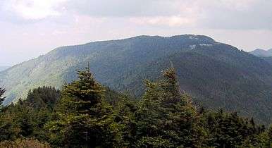
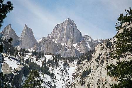 Mount Whitney is the highest summit of the Sierra Nevada, the State of California, and the "Lower 48" contiguous United States.
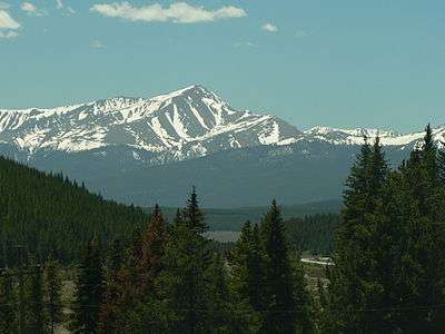
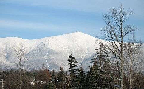
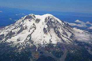 Mount Rainier is the highest summit of the Cascade Range and the State of Washington
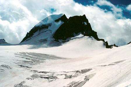
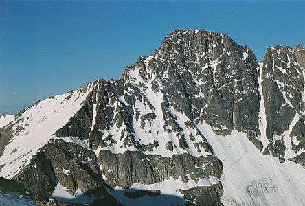
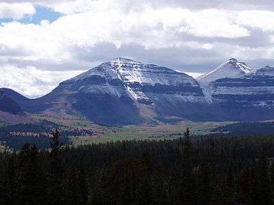 Kings Peak is the highest summit of the Uinta Range and the State of Utah.
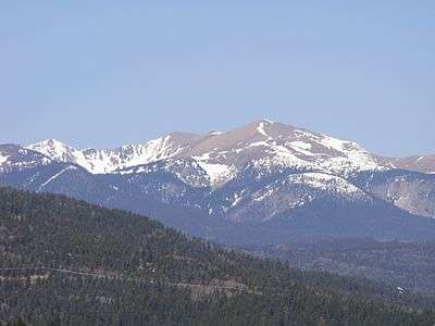
 Granite Peak is the highest summit of the Beartooth Range and the State of Montana.
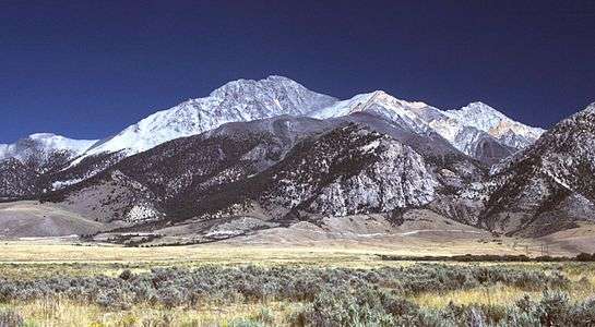
 Mount Katahdin is the highest summit of the State of Maine
 Lake Michigan is the lowest area of the State of Wisconsin.
 Britton Hill in the State of Florida is the lowest state high point in the United States.
 Lake Champlain is the lowest area of the State of Vermont.
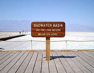 The Badwater Basin in Death Valley is the lowest area of the State of California, the United States, and all of North America.
.jpg) Cerro de Punta, the highest point in Puerto Rico, seen from Ponce (highest point in U.S. outside the 50 states)
Cerro de Punta, the highest point in Puerto Rico, seen from Ponce (highest point in U.S. outside the 50 states)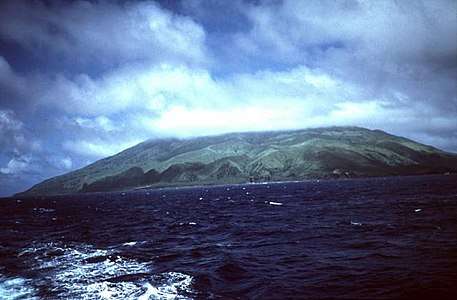 Agrihan is the highest point in the Northern Mariana Islands
Additional highest U.S. areas
- Highest points in the U.S. Minor Outlying Islands, mostly unnamed:[52]
- Baker Island – 8 m (26.2 ft)
- Howland Island – 3 m (9.8 ft)
- Jarvis Island – 7 m (23 ft)
- Johnston Atoll (Sand Island) – 10 m (32.8 ft)
- Kingman Reef – less than 2 m (less than 6.5 ft)
- Midway Atoll – water tower hill (Sand Island) — 15 m (49.21 ft)[53] (Highest point of the U.S. Minor Outlying Islands in the Pacific Ocean)
- Navassa Island – 85 m (278.5 ft) (Highest point of the U.S. Minor Outlying Islands)
- Palmyra Atoll – 3 m (9.8 ft)
- Wake Island – 8 m (26.2 ft)[54]
See also

- Highpointing
- List of elevation extremes by country
- List of elevation extremes by region
- United States
- U.S. state
- Lists of U.S. states
- Lists of highest points for other highpoint lists
- Lists of U.S. states
- List of mountain peaks of the United States
- List of highest United States cities by state
- U.S. state
- World Geodetic System
Notes
- Connecticut is the only state with a high point that is not a topographic summit; its highest summit is Bear Mountain, at 2,323 feet (708 m), approximately 1.3 miles southeast of Mount Frissell.[21]
References
- "Elevations and Distances in the United States". Reston, Virginia: USGS. April 29, 2005. Archived from the original on November 20, 2010. Retrieved October 24, 2011. Originally published in 1995.
- "USGS National Elevation Dataset (NED) 1 meter Downloadable Data Collection from The National Map 3D Elevation Program (3DEP) - National Geospatial Data Asset (NGDA) National Elevation Data Set (NED)". United States Geological Survey. September 21, 2015. Retrieved September 22, 2015.
- Holmes, Don W. (2000). Highpoints of the United States: A Guide to the Fifty State Summits. University of Utah Press. ISBN 0-87480-645-3.
- Regenold, Stephen (June 10, 2006). "Seeing the highpoints of every state". Pittsburgh Post-Gazette. Associated Press. Retrieved December 4, 2008.
- "Highpointers Club Frequently Asked Questions". highpointers.org. Archived from the original on July 22, 2007. Retrieved December 4, 2008.
- "What is a geodetic datum?". Frequently Asked Questions about the National Geodetic Survey. Retrieved October 19, 2011.
- "U.S. State Highpoints". summitpost.org. Retrieved November 28, 2008.
- "U.S. State High Points". peakbagger.com. Retrieved October 20, 2011.
- "Cheehahaw". NGS data sheet. U.S. National Geodetic Survey. Retrieved October 20, 2011.
- The summit of Denali is the highest point in North America and the United States of America. The summit of Denali is the third-most prominent summit and the third-most isolated summit on Earth after Mount Everest and Aconcagua.
- hahttps://www.cia.gov/library/publications/the-world-factbook/geos/aq.html
- "Frisco". NGS data sheet. U.S. National Geodetic Survey. Retrieved October 20, 2011.
- "Mag". NGS data sheet. U.S. National Geodetic Survey. Retrieved October 20, 2011.
- "Whitney". NGS data sheet. U.S. National Geodetic Survey. Retrieved October 21, 2015.
- The summit of Mount Whitney is the highest point in the contiguous United States.
- The Badwater Basin in Death Valley is the lowest point in North America and the United States of America.
- "Mount Elbert". NGS data sheet. U.S. National Geodetic Survey. Retrieved October 21, 2015.
- The summit of Mount Elbert is the highest point of the Rocky Mountains of North America.
- The Arikaree River at the point where it exits the State of Colorado is the highest state low point of the 50 United States.
- Sanderson, Dale. "Arikaree River - Lowest Point in Colorado". Archived from the original on March 28, 2012. Retrieved October 20, 2011.
- "Bear Mountain, Connecticut". Peakbagger.com.
- "Highest Point in Delaware". Delaware Geological Survey. Archived from the original on October 5, 2011. Retrieved October 20, 2011.
- "Regarding the highest point in Delaware". Delaware Repeater Association. Archived from the original on 2011-07-26. Retrieved October 20, 2011.
- Dvorak, Petula. "D.C.'s Puny Peak Enough to Pump Up 'Highpointers'". The Washington Post. Retrieved 1 January 2015.
- https://www.cia.gov/library/publications/the-world-factbook/geos/gnq.html%5B%5D
- "Summit USGS 1977". NGS data sheet. U.S. National Geodetic Survey. Retrieved October 20, 2011.
- The summit of Mauna Kea is the highest point in Oceania. Mauna Kea is also the tallest mountain on Earth as measured from base to summit. The shield volcano sits on the floor of the Pacific Ocean at a depth of 5,998 meters (19,678 ft) for a total height of 10,205.3 meters (33,482 ft)
- "Beauty Reset". NGS data sheet. U.S. National Geodetic Survey. Retrieved October 20, 2011.
- "Charles". NGS data sheet. U.S. National Geodetic Survey. Retrieved October 20, 2011.
- "Katahdin 2". NGS data sheet. U.S. National Geodetic Survey. Retrieved October 21, 2015.
- "Greylock RM 1 Reset". NGS data sheet. U.S. National Geodetic Survey.
- "Knob Reset". NGS data sheet. U.S. National Geodetic Survey.
- "Granite Peak". NGS data sheet. U.S. National Geodetic Survey. Retrieved October 21, 2015.
- "Boundary". NGS data sheet. U.S. National Geodetic Survey. Retrieved October 20, 2011.
- "Mt Wash". NGS data sheet. U.S. National Geodetic Survey. Retrieved October 20, 2011.
- The summit of Mount Washington is the highest point on the northeastern Northern American Continent.
- "Wheeler". NGS data sheet. U.S. National Geodetic Survey. Retrieved October 21, 2015.
- "Marcy". NGS data sheet. U.S. National Geodetic Survey. Retrieved October 21, 2015.
- The summit of Mount Mitchell is the highest point on the eastern Northern American Continent.
- "The World Factbook — Central Intelligence Agency". www.cia.gov. Retrieved 30 March 2018.
- "Mount Hood Highest Point". NGS data sheet. U.S. National Geodetic Survey. Retrieved October 21, 2015.
- "The World Factbook — Central Intelligence Agency". www.cia.gov. Retrieved 30 March 2018.
- "Black Elk Peak". NGS data sheet. U.S. National Geodetic Survey. Retrieved August 13, 2016.
- "El Capitan". NGS data sheet. U.S. National Geodetic Survey. Retrieved October 20, 2011.
- "Kings Peak, Utah". Peakbagger.com. Retrieved 2009-12-27.
- "Mt Mansfield Highest Point". NGS data sheet. U.S. National Geodetic Survey. Retrieved October 20, 2011.
- "The World Factbook — Central Intelligence Agency". www.cia.gov. Retrieved 30 March 2018.
- The summit of Mount Rainier is the most prominent point in the contiguous United States.
- "Spruce Knob Cairn 1956". NGS data sheet. U.S. National Geodetic Survey. Retrieved October 21, 2015.
- "Gannett Peak Cairn". NGS data sheet. U.S. National Geodetic Survey. Retrieved October 21, 2015.
- "The World Factbook — Central Intelligence Agency". www.cia.gov. Retrieved 30 March 2018.
- https://www.cia.gov/library/publications/the-world-factbook/geos/mq.html CIA World Factbook. Midway Atoll. Retrieved August 29, 2019.
- "The World Factbook — Central Intelligence Agency". www.cia.gov. Retrieved 30 March 2018.
External links
Highest natural points of U.S. states and additional U.S. areas | ||
|---|---|---|
| ||
| Additional U.S. areas | ||