Charles Mound
Charles Mound[3] is a gentle, 1,235-foot (376 m) high hill in northern Jo Daviess County, Illinois, United States, near the small town of Scales Mound, and 11 miles (18 km) northeast of Galena. It is the highest natural point in the state; thus, it is considered a highpoint.
| Charles Mound | |
|---|---|
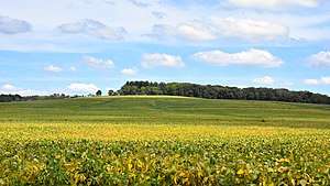 Looking eastward at Charles Mound, the highest point in Illinois from Elizabeth Scales Mound Road, September 2016 | |
| Highest point | |
| Elevation | 1,235 ft (376 m) NAVD 88[1] |
| Prominence | 95 ft (29 m) [2] |
| Listing | U.S. state high points 45th |
| Coordinates | 42°30′15″N 90°14′23″W [1] |
| Geography | |
 Charles Mound Illinois state highpoint | |
| Location | Jo Daviess County, Illinois, United States |
| Topo map | USGS Shullsburg |
Geography
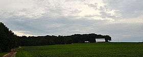
Charles Mound is the highest natural point in Illinois. (The highest point is the Willis Tower, formerly known as the Sears Tower.) The top of the hill is about 0.25 miles (400 m) from the Wisconsin border. It is within the Driftless Area, a region of Illinois, Iowa, Minnesota, and Wisconsin that was not covered or ground down by the last continental glaciers. The hill itself is an erosional remnant, similar to that on which the original village site of Scales Mound was located. Shallow Elizabeth silt loam soil is on the summit and the surrounding area has deeper silty clay loam of the Lacrescent series.[4]
Settlement
Elijah Charles, one of the region's first permanent settlers, arrived in 1828 and settled at the base of the mound and the hill assumed his name.[5]
Access
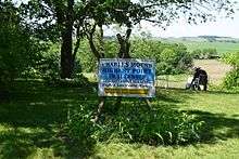
Charles Mound is located on rolling farmland. The land owners, Jean and Wayne Wuebbels, allow public access on the first full weekends of the months of June, July, August, and September.[6]
See also


- List of U.S. states by elevation
References
- "Charles". NGS data sheet. U.S. National Geodetic Survey. Retrieved 2008-12-17.
- "Charles Mound, Illinois". Peakbagger.com. Retrieved 2012-10-17.
- U.S. Geological Survey Geographic Names Information System: Charles Mound
- https://casoilresource.lawr.ucdavis.edu/gmap/
- Mansberger, Floyd (1990-04-02). "Scales Mound Historic District" (PDF). National Register of Historic Places Registration Form. Illinois Historic Preservation Agency. Archived from the original (PDF) on 2008-06-25. Retrieved 2008-12-17.
- "2011 Access Dates for Illinois". The Highpointers Foundation. 2011-02-01. Retrieved 2011-08-20.
External links
| Wikimedia Commons has media related to Charles Mound. |
- "Charles Mound". Property Information Report. Illinois Geographic Information System. Archived from the original on 2011-07-20. Retrieved 2008-12-17.
- "2003 Highpointers Convention". The Highpointers Foundation. Archived from the original on 2007-03-03. Retrieved 2008-12-17.
Highest natural points of U.S. states and additional U.S. areas | ||
|---|---|---|
| ||
| Additional U.S. areas | ||