Khoksa Upazila
Khoksa (Bengali: খোকসা) is an Upazila of Kushtia District in the Division of Khulna, Bangladesh.[1]
Khoksa খোকসা | |
|---|---|
Upazila | |
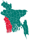
 Khoksa Location in Bangladesh | |
| Coordinates: 23°48′N 89°17′E | |
| Country | |
| Division | Khulna Division |
| District | Kushtia District |
| Area | |
| • Total | 99.17 km2 (38.29 sq mi) |
| Population (2011) | |
| • Total | 129,551 |
| • Density | 1,300/km2 (3,400/sq mi) |
| Time zone | UTC+6 (BST) |
| Postal code | 7020 |
| Website | Official Map of Khoksa |
Geography
Khoksa is located at 23.8000°N 89.2833°E . It has 16,424 households and a total area of 99.17 km².
Demographics
According to 2011 Bangladesh census, Khoksa had a population of 129,551. Males constituted 49.78% of the population and females 50.22. Muslims formed 90.548% of the population, Hindus 9.443%, Christians 0.008% and others 0.006%. Khoksa had a literacy rate of 44.7% for the population 7 years and above.[2]
According to the 1991 Bangladesh census, Khoksa had a population of 93,371. Males constituted 51.65% of the population, and females 48.35%. The population aged 18 or over was 47,024. Khoksa had an average literacy rate of 25.2% (7+ years), compared to the national average of 32.4%.[3]
Administration
Khoksa has 3 Unions/Wards, 79 Mauzas/Mahallas, and 92 villages.
Education
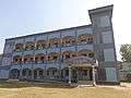
Educational Institutions: Khoksa (Bengali: খোকসা) . has a number of educational institutions. Khokha Government College, Kushtia (Bengali: খোকসা সরকারি কলেজ, কুষ্টিয়া) and Khoksa-Janipur Pilot High School (Bengali: খোকসা জানিপুর পাইলট উচ্চ বিদ্যালয়)are mentionable. These educational institutions have a glorious history and reputation. Students of these institutions are making brilliant results in public examinations. Besides there are Shomospur High School, Khoksa Janipur Pilot Girls High School, Iswardi High School, Bonogram High School, Moragacha High School etc.
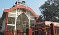
Khoksa Janipur Pilot High School - Since 1900a..
References
- Kamruzzaman (2012), "Khoksa Upazila", in Sirajul Islam and Ahmed A. Jamal (ed.), Banglapedia: National Encyclopedia of Bangladesh (Second ed.), Asiatic Society of Bangladesh
- "Bangladesh Population and Housing Census 2011: Zila Report – Kushtia" (PDF). Table P01 : Household and Population by Sex and Residence, Table P05 : Population by Religion, Age group and Residence, Table P09 : Literacy of Population 7 Years & Above by Religion, Sex and Residence. Bangladesh Bureau of Statistics (BBS), Ministry of Planning, Government of the People’s Republic of Bangladesh. Retrieved 9 December 2018.
- "Population Census Wing, BBS". Archived from the original on 2005-03-27. Retrieved November 10, 2006.
| Upazila/Thana: | ||
|---|---|---|