Kumarkhali Upazila
Kumarkhali (Bengali: কুমারখালি) is an Upazila of Kushtia District in the Division of Khulna, Bangladesh.[1] It is famous for the Shelaidaha area, where the poet Rabindranath Tagore spent a considerable time of his youth.
Kumarkhali কুমারখালি (কুষ্টিয়া) | |
|---|---|
Upazila | |
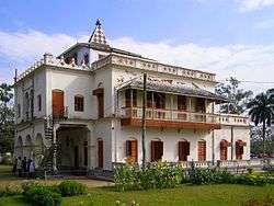 Shilaidaha Kuthibari, the famous residence of Rabindranath Tagore, is located at Kumarkhali | |
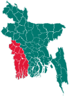
 Kumarkhali Location in Bangladesh | |
| Coordinates: 23°51′15.12″N 89°14′30.12″E | |
| Country | |
| Division | Khulna Division |
| District | Kushtia District |
| Capital | Kumarkhali |
| Area | |
| • Total | 265.89 km2 (102.66 sq mi) |
| Population (2011) | |
| • Total | 328,457 |
| • Density | 1,200/km2 (3,200/sq mi) |
| Time zone | UTC+6 (BST) |
| Website | Official site Official map of Kumarkhali |
Geography
Kumarkhali is located at 23.8542°N 89.2417°E . It has 48387 households and total area 265.89 km².
Demographics
According to 2011 Bangladesh census, Kumarkhali had a population of 328,457. Males constituted 49.77% of the population and females 50.23. Muslims formed 96.757% of the population, Hindus 3.297%, Christians 0.005% and others 0.003%. Kumarkhali had a literacy rate of 45.3% for the population 7 years and above.[2]
At the 1991 Bangladesh census Kumarkhali had a population of 269,008, of whom 133,845 were aged 18 or older. Males constituted 51.77% of the population, and females 48.23%. Kumarkhali had an average literacy rate of 24.9% (7+ years), against the national average of 32.4%.[3]
Administration
Kumarkhali has 11 Unions and about 150 villages.
See also
- Upazilas of Bangladesh
- Districts of Bangladesh
- Divisions of Bangladesh
References
- Shiek Md Badrul Alam Tipu (2012), "Kumarkhali Upazila", in Sirajul Islam and Ahmed A. Jamal (ed.), Banglapedia: National Encyclopedia of Bangladesh (Second ed.), Asiatic Society of Bangladesh
- "Bangladesh Population and Housing Census 2011: Zila Report – Kushtia" (PDF). Table P01 : Household and Population by Sex and Residence, Table P05 : Population by Religion, Age group and Residence, Table P09 : Literacy of Population 7 Years & Above by Religion, Sex and Residence. Bangladesh Bureau of Statistics (BBS), Ministry of Planning, Government of the People’s Republic of Bangladesh. Retrieved 9 December 2018.
- "Population Census Wing, BBS". Archived from the original on 2005-03-27. Retrieved November 10, 2006.
| Upazila/Thana: | ||
|---|---|---|