Green Line (MBTA)
The Green Line is a light rail system run by the Massachusetts Bay Transportation Authority (MBTA) in the Boston, Massachusetts, metropolitan area. It is the oldest Boston rapid transit line, and with tunnel sections dating from 1897, the oldest in America.[4] It runs as a deep-level subway through downtown Boston, and on the surface into inner suburbs via four branches on several radial boulevards. With an average daily weekday ridership of 152,200 in 2019, it is the second most heavily used light rail system in the country.[1] The line was assigned the green color in 1967 during a systemwide rebranding because several branches pass through sections of the Emerald Necklace of Boston.[5][6][7]

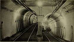
The four branches are the remnants of a large streetcar system, which began in 1856 with the Cambridge Horse Railroad and was consolidated into the Boston Elevated Railway several decades later. The branches all travel downtown through the Tremont Street subway, the oldest subway tunnel in North America. The Tremont Street subway opened its first section on September 1, 1897, to take streetcars off overcrowded downtown streets; it was extended five times over the next five decades. The streetcar system peaked in size around 1930 and was gradually replaced with trackless trolleys and buses, with cuts as late as 1985. The new D branch opened on a converted commuter rail line in 1959; the Green Line Extension project will extend two branches into Somerville and Medford, and is planned for completion in 2021.[8]
Route description
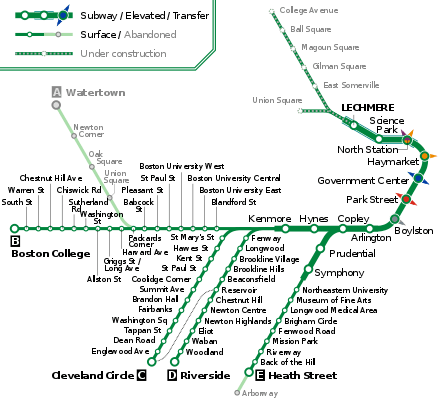
The Green Line is based around the central subway, a group of tunnels which run through the urban core of Boston.[9] The Tremont Street subway runs roughly north–south through downtown, with stations at Boylston, Park Street, Government Center, Haymarket, and North Station – all with connections to other lines of the MBTA subway system. The Boylston Street subway runs roughly east–west through the Back Bay neighborhood, with stations at Arlington, Copley, Hynes Convention Center, and Kenmore; it connects to the Tremont Street subway at Boylston. The Huntington Avenue subway diverges from the Boylston Street subway at a flat junction west of Copley, running southwest with stations at Prudential and Symphony.[10]:96 A branch of the Tremont Street subway, disused since 1962, runs south from Boylston to the former Pleasant Street incline.
North of North Station, the line inclines up to the Lechmere Viaduct, which crosses the Charles River with an elevated station at Science Park. The Green Line is closed north of North Station from May 24, 2020, to 2021 for construction of the Green Line Extension (GLX). The GLX will continue north from the Lechmere viaduct, with an elevated Lechmere station in East Cambridge replacing the former surface terminal. Two branches will split north of Lechmere: the Union Square branch to Union Square via the Fitchburg Line right-of-way, and the Medford branch to Medford/Tufts via the Lowell Line right-of-way.
The Green Line has four western surface branches, each with a letter designation:
- The B branch runs west in a short tunnel from Kenmore, surfacing in the median of Commonwealth Avenue at Blandford Street. It runs 4.2 miles (6.8 km) on Commonwealth Avenue through Boston University, Allston, and Brighton to Boston College station. As of 2020, Park Street is the downtown terminus of B Branch service.
- The C branch runs southwest in a tunnel from Kenmore, surfacing in the median of Beacon Street at St. Marys Street. It runs 2.9 miles (4.7 km) on Beacon Street through Brookline to Cleveland Circle station. As of 2020, North Station is the downtown terminus of C branch service.
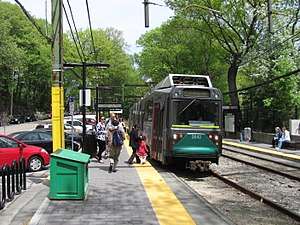
- The D branch diverges from the C branch tunnel southwest of Kenmore, surfacing at Fenway station. It runs 9.7 miles (15.6 km) though Brookline and Newton along the grade-separated Highland branch (a former Boston and Albany Railroad commuter rail line) to Riverside station. As of 2020, Government Center is the downtown terminus of D branch service.
- The E branch runs southwest through the Huntington Avenue subway from Copley, surfacing in the median of Huntington Avenue at Northeastern University station. It runs 2.6 miles (4.2 km) along Huntington Avenue and South Huntington Avenue to Heath Street, with the outer 0.7 miles (1.1 km) (west of Brigham Circle) in mixed traffic rather than a dedicated median. Until 1985, the line continued south through Jamaica Plain to Arborway.[5] As of 2020, North Station is the downtown terminus of E Branch service.
Former branches
The Green Line A branch was the northernmost of the branches, running from the Blandford Street portal (still used by the B branch), west to Watertown, mostly street-running. The 57 bus replaced the streetcar line in 1969. The A branch diverged from Commonwealth Avenue west of Boston University and ran to a terminus in Watertown, across the Charles River from Watertown Square, until 1969. Although the route-letter scheme had been introduced two years prior to its closure, the "A" designation was never signed on streetcars to Watertown. It was, however, included in the destination signs on the Boeing-Vertol LRVs ordered in the mid-1970s, when reopening service to Watertown was under consideration. The "A" line tracks remained in non-revenue service to access maintenance facilities at Watertown until 1994.
No branches had used the Canal Street portal (except as a terminal) after 1949 or the Pleasant Street portal after 1961. All Green Line trains stop at Park Street, Boylston, Arlington, and Copley. All trains except "E" also stop at Hynes Convention Center and Kenmore. Only "E" trains stop at Prudential and Symphony.
The Pleasant Street portal hosted two services in its final days. The 9 to City Point ended in 1953, and the 43 to Egleston was cut back to Lenox Street in 1956, cut back to the portal in 1961, and ended operation in 1962. Prior to that, the 48 ran out Tremont Street to Dover Street and Washington Street, ending at Dudley, and last running in 1938.
The last two routes to continue beyond the Canal Street portal both ran to Sullivan. The 92 ran via Main Street, last running in 1948, and the 93 via Bunker Hill Street last ran in 1949. Until 1997 trains continued to use the portal and its North Station surface station as a terminal.
In addition to the lines that later became the E branch, the predecessors to the 58 and 60 split in Brookline, one branch running into the current "E" tracks and into the Boylston Street portal, and the other running up Brookline Street to end at Massachusetts Avenue station. These were truncated in 1932 into a shorter route from Brookline Village to the subway via the Boylston Street portal, which itself stopped running in 1938 (being cut back to Brigham Circle short-turn trips), three years before the closure of that portal.
The last "foreign" cars to operate in the subway were those of the Eastern Massachusetts Street Railway, running from the Canal Street portal to the Brattle Loop at Scollay Square until 1935. It was then that the old Mystic River Bridge to Chelsea was closed to streetcars and the lines were replaced by bus service; the next year the BERy bought the Eastern Mass Chelsea Division and through-routed it with its lines connecting to the East Boston Tunnel at Maverick.
From the Lechmere terminal opening on July 10, 1922 to February 6, 1931, special service ran from Lechmere to various points on the subway. These trips were replaced on February 7, 1931 by extensions of the various branches from the west, which had terminated at Park Street, through to Lechmere.
Inclines/portals
Cars entered the subway from the surface at a number of portals or inclines, listed here from north to south/east to west.
Lechmere
Lechmere was the north end of the Green Line until 2020. From the opening of the Lechmere Viaduct leading to it in 1912 until 1922, streetcar lines simply fed onto the viaduct from Cambridge Street and Bridge Street (now Monsignor O'Brien Highway). In 1922 a prepayment station was opened, with a new loop for subway trains to turn around and a separate loop for surface cars, and no intermingling between the two. The surface lines have since been replaced with buses, but the Green Line still looped at Lechmere until 2020.
Canal Street
The Canal Street portal (also Haymarket portal, North Station portal or Causeway Street portal, often referred to in revenue service as the Canal Street loop) was part of the transition between subway and elevated railway on the Green Line, as it transitioned from the Tremont Street subway to the Causeway Street elevated towards the Lechmere Viaduct until 2004, when the Green Line north of North Station was closed for building of a new tunnel and portal. Certain trains turned at Canal Street, while others emerged from the subway to a viaduct to Lechmere. It was, however, possible for a passenger to alight from a train at Canal Street and proceed up a series of stairways to the Lechmere Viaduct. However, most passengers desiring to continue to Science Park or Lechmere would have changed to a Lechmere signed car from a North Station signed car prior to the emergence from the central subway.
The original four-track portal opened in 1898 at the north end of the first subway; cars could turn east or west on Causeway Street. In 1901 the Charlestown Elevated was connected to the outer tracks, and streetcars only operated via the inner tracks. The Washington Street Tunnel opened in 1908, connecting to the Elevated via a new portal just east of the streetcar one, and all four tracks were once again open for streetcar use until 1975. In 1912 the Lechmere Viaduct opened, again using the two outer tracks for an elevated line. The inner tracks continued to serve the surface, including a surface station at North Station, until 1997, when they were closed for construction of the new tunnel and the Green Line was shifted to the old Orange Line (Charlestown Elevated) portal along the way. The 93 was the last service to continue onto surface streets from the portal, last running in 1949.
Pleasant Street
The Pleasant Street portal was the south end of the Tremont Street subway, opened one month after the original subway in 1897. It split from the Boylston Street subway at a flying junction at Boylston, and another flying junction split the tunnel into two side-by-side tunnels to the four-track portal. The two west tracks rose onto Tremont Street and the two east ones onto Pleasant Street, later part of Broadway. From 1901 to 1908 the portal was only used by Washington Street Elevated trains, after which streetcar service was restored—though much of it had been cut back to Dudley for transfer to the Elevated. Until 1953 service ran to City Point at eastern end of South Boston as part of 9. The last cars ran through the portal in 1961 as part of the 43, and in 1962 a shuttle service from Boylston to the portal was ended. The portal has since been covered, but someday may become part of a new streetcar line that would partly replace access to rapid transit for southern Metro Boston neighborhoods, that had been severed from MBTA rapid transit service in 1987 with the demolishing of the Washington Street Elevated original southern section of the Orange Line. This proposed new streetcar service could go as far south as the Red Line's Mattapan station, with a northern turnaround terminus at Government Center, according to a 2012-dated proposal.[11]
Public Garden and Boylston Street
The first portal to open, on September 1, 1897, was the Public Garden portal, providing an outlet for the subway on the north side of Boylston Street in the Public Garden. When the Boylston Street subway opened in 1914, extending the subway west, the incline and portal were relocated to the center of Boylston Street as the Boylston Street portal. The last cars to use the portal ran in 1941 from Huntington Avenue, when the Huntington Avenue subway opened as a branch off the main subway and the portal was closed.
Northeastern
The Northeastern portal lies in the median of Huntington Avenue at the end of the Huntington Avenue subway, just east of Northeastern University. It opened in 1941 and carries E branch trains.
The incline was built as a wooden trestle to the street atop a level grade, as the original plans called for eventual extension of the subway; in the mid 1980s the trestle was replaced with fill (which greatly quieted the sound).
Kenmore

The Kenmore portal or Kenmore Square portal opened in 1914 with the extension of the Boylston Street subway westward to the east side of Kenmore Square, in the median of Commonwealth Avenue. It closed in 1932 when the subway station at Kenmore was built and two new portals were opened to the west.
Blandford Street, St. Marys Street, and Fenway
The Blandford Street portal and St. Marys Street portal, in the medians of Commonwealth Avenue and Beacon Street respectively, opened in 1932 as part of the extension of the Boylston Street subway under Kenmore Square and the opening of the new Kenmore station. They are currently used by the "B" and "C" Branches respectively. The Fenway portal opened in 1959 along with the opening of the Highland branch, and provides a third exit from Kenmore, south of the St. Marys Street portal. It carries trains of the D branch.
Rolling stock
Like the three other MBTA subway lines, the line uses standard gauge tracks. However, instead of heavy rail metro rolling stock, the Green Line uses modern streetcars (light rail vehicles) as heavy rail stock would be inappropriate for the surface branches with their numerous grade crossings.
Listing
Active fleet
Rolling stock as of June 2020:[2][12][13]
| Year Built | Manufacturer | Model | Image | Length | Width | Fleet Numbers | Quantity |
|---|---|---|---|---|---|---|---|
| 1986–1988 | Kinki Sharyo | Type 7 LRV | 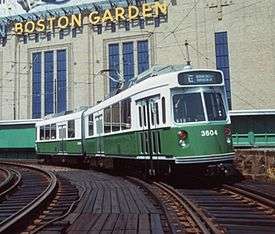 |
72 ft (22 m) | 104 in (2.64 m) | 3600–3699 | 100 (84 active, all overhauled)
|
| 1997 |  |
3700–3719 | 20 (17 active, all overhauled)
| ||||
| 1998–2007 | AnsaldoBreda | Type 8 LRV | 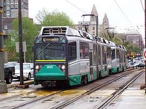 |
74 ft (23 m) | 104 in (2.64 m) | 3800–3894 | 94 (85 active) |
| 2018-2019 | CAF USA | Type 9 LRV | 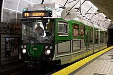 |
74 ft (23 m) | 104 in (2.64 m) | 3900–3923 | 24 (16 active. Deliveries to continue throughout 2020) |
Retired fleet
Only MBTA operated vehicles are included here, not cars from the Boston Elevated Railway (BERy) era.
| Years in Service | Manufacturer | Model | Image | Length | Width | Fleet Numbers | Quantity |
|---|---|---|---|---|---|---|---|
| 1976–2007 | Boeing Vertol | US Standard Light Rail Vehicle | 71 ft (22 m) | 104 in (2.64 m) | 3400–3543 | 144 (31 units cancelled) | |
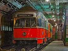
| 1937–19851 | Pullman Standard | PCC streetcar | 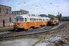 |
48 ft (15 m) | 100 in (2.54 m) | 3000–3346 | 344 (2 cars scrapped before 1964) |
^1 Ten PCC streetcars are currently in revenue service on the Ashmont–Mattapan line.
History
Early rolling stock
When it opened at the end of the 19th century, the Tremont Street subway was not intended as a full-scale rapid transit line (though it was built to pre-metro standards), but to allow ordinary streetcars to bypass the worst street congestion in downtown Boston.[4][14] Operations by several different companies were eventually consolidated into the Boston Elevated Railway, which ran a mixture of car types. After receiving a test unit in 1937, the BERy began to standardize on PCC streetcars, acquiring 320 units between 1941 and 1951 plus an additional 25 in 1959 to phase out the last older cars.[12]
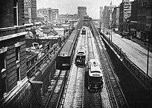
Boeing LRV
.jpg)
In the early 1970s, light rail—which had largely disappeared from North America after the slow decline of streetcar systems from the 1920s to the 1950s—was reintroduced as a method of urban renewal less expensive than conventional metro systems.[15] In 1971, as part of a program to supply further work to defense contractors as the Vietnam War wound down, the Urban Mass Transit Administration selected Boeing Vertol as systems manager for a project to design a new generation of generic light rail vehicle.[16]
After a 1972 report by Prof. Vukan R. Vuchic,[17] Boston (with its older streetcar tunnel systems) and San Francisco (with a new Muni Metro streetcar tunnel being built as part of BART construction) were chosen as the testbeds for this new rolling stock, intended to jumpstart similar systems in other cities.[15] The US Standard Light Rail Vehicle was designed as the largest rolling stock that would fit through the Tremont Street tunnel, the Muni Metro's Twin Peaks Tunnel, and SEPTA's subway–surface lines tunnel.[14] The new cars were faster—a top speed of 50 miles per hour (80 km/h) versus the PCC's 36 miles per hour (58 km/h)—and had an articulated middle section for higher capacity.[14] Boeing began construction of 175 cars for the MBTA in May 1973.[16]
The first LRVs entered service on the D branch in December 1976 but were immediately beset with problems. Certain cars frequently derailed on tight turns in the Riverside, Boston College and Lechmere yards. Battery trays, air conditioners—mounted under the cars, continually drawing in dirt and debris from under the car when in the tunnels—and air compressors all suffered numerous failures; the plug-style doors had trouble sealing properly; and traction motors failed sooner than expected.[18] Desperate for reliable rolling stock, the MBTA launched an overhaul program to extend the availability of its older PCC cars. A total of 34 cars, primarily out-of-service wrecks and parts cars, were rebuilt to as-new condition.[18] In 1980, the MBTA tested Canadian Light Rail Vehicles for three months to determine whether they could be used on the Green Line.[19]
As of 2013, ten of the rebuilt PCC cars still run on the Ashmont–Mattapan section of the Red Line, because maintaining the small PCC fleet is less expensive than rebuilding the rail line for modern light rail or heavy rail stock.[12][18] Because these heritage streetcars operate exclusively on a dedicated right of way which has only two grade crossings (instead of using street running), they are less exposed to collisions in mixed road traffic.
Modern fleet

In 1986–88, 100 second generation (Type 7) LRVs were delivered from the Japanese firm Kinki Sharyo, with an additional 20 cars ordered and delivered in 1997.[20] The first low-floor Green Line streetcars, allowing for handicapped-accessible boarding directly from slightly raised platforms, were the Type 8 cars from AnsaldoBreda which began arriving in 1998.[12] The first Type 8s entered revenue service in March 1999, but they were prone to derailment at higher speeds as well as brake problems; not until 2008 did they assume full service on the D branch (where they reach full speed).[5] One hundred low-floor cars were purchased from the Italian company AnsaldoBreda, with styling by Pininfarina. They were initially problematic and difficult to maintain: the first cars failed every 400 miles (640 km), far short of the 9,000 miles (14,000 km) specified by the MBTA, and were prone to derailments. The MBTA has been forced to spend an additional US$9.5 million to modify tracks to prevent the derailments, echoing early problems with the Boeing stock. The MBTA has been criticized for their failure to assess Bredas' reliability before entering into the deal, and during delivery.
In December 2004, the MBTA canceled orders for the cars still to be delivered as part of the authority's nine-year, US$225 million deal with Breda.[21] One year later, in December 2005 the MBTA announced that it had entered into a restructuring of the deal, reducing the order to 85 cars (with spare parts to be provided in lieu of the 15 remaining cars), and providing for the remaining payment under the original deal only if the cars met performance requirements.[22] Construction of the last car under the order was completed on December 14, 2006.[23] After additional delays on the Type 8 car order, the last 10 cars were assembled and delivered in late 2007, with five spare shells retained (95 cars in service). After several years of modifications to D branch tracks, the Breda cars returned to service on that line, and now provide service on every branch of the Green Line. As the final Type 8s were delivered, the last of the Boeing-Vertol cars were retired in March 2007 and all except ten of the cars were scrapped.[24] Of the remaining cars, six were sold to the US Government and are now in Pueblo, Colorado for testing purposes, one was given to the Seashore Trolley Museum, and three were retained by the MBTA for work service.
Of the 120 Type 7 cars 103 were overhauled by Alstom in Hornell, New York. The work includes new propulsion systems, climate control systems and interiors as well as exterior work. The pilot car for the program left in October 2012 and was returned in November 2014, with the last car returned in April 2019.[25][12]
Twenty-four new Type 9 Green Line cars are being delivered. Revenue service began in late 2018 and all 24 cars will have entered service by the fall of 2019. The Type 9 cars will provide additional rolling stock to allow for Green Line Extension operations, and will not replace any of the existing fleet.[26] The cars will be made by CAF USA, Inc., with the shells and frames made in Spain, and final assembly and testing done at their plant in Elmira, New York.[27] As of March 2017, the first unit had been expected to enter passenger service in Spring 2018, with all 24 cars in service by the end of the year.[28] The first Type 9 car, #3900, began revenue service on December 21, 2018.[29]
Planning for a Type 10 fleet—which would likely replace all Type 7 and Type 8 cars in the mid-2020s—began in 2018 with plans for a fully low floor fleet. As of November 2019, the MBTA planned to release an RFP in early 2020, with notice to proceed given in early 2021.[30]
Display cars
Two older streetcars are on display on the unused outer inbound track at Boylston station, which formerly carried cars coming from the Pleasant Street portal. Car #5734, a Type 5 A-1 car built in 1924 and retired in 1959, is owned by the Seashore Trolley Museum, but resides semipermanently in Boston. PCC #3295, built in 1951 and retired in 1986, is owned by the MBTA.[12] The cars were formerly used for fantrips, the most recent one being in 1997. These trolleys are no longer in working condition, however. The cars were heavily vandalized on January 14, 2014, but the vandalism was fully removed the next day.[31]
The San Francisco Municipal Railway runs a variety of PCC cars in various paint schemes on its F Market heritage line. Number 1059 is painted in Boston Elevated Railway colors, but that individual car never ran in Boston.[32]
Accessibility
The Red Line, Blue Line, and Orange Line run rapid transit cars and use stations with high platforms level with the car floor providing easy access for the disabled. The Green Line originated as a streetcar line, and used a variety of streetcars before converting to light rail vehicles.
Originally all the Green Line stations had platforms at track level, and passengers had to ascend several steps up into the vehicles. This limited accessibility for persons with disabilities. To address this issue and comply with changing federal and state laws, additional facilities have been added:[33]
- Wheelchair lifts have been provided at some stops. They are rolled up to the car door and the lift mechanism is operated using a hand crank. They are quite time-consuming to operate, causing significant delays when used during peak periods.
- Short platforms level with car floors, accessed by ramps, were installed just before or after selected stations. Because the car door arrangement required a large gap between the platform and the car, a bridge plate attached to the raised platform had to be positioned after the train stopped with a door at that platform.
- The MBTA has followed the worldwide trend of operating low-floor streetcars. As an ongoing project, not complete in 2012, platforms are being raised slightly to about the height of a street curb. Low-floor cars have remotely controlled bridge plates at the center doors to allow wheelchairs and strollers to reach the car floor a few inches higher.
History
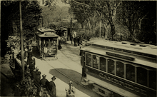
Beginning in the 1850s, Boston sprouted a large network of horsecar lines, the first public transit in the city. The West End Street Railway was created by the state legislature in 1887 to build a single line, but soon consolidated many of the existing lines into a single privately owned system with consistent fares and route designations. The Allston – Park Square line (which served the general area of the A branch) was the first section to be converted to electric traction in 1889. It used modified existing horsecars outfitted with Frank J. Sprague's revolutionary electrical equipment, which had first been demonstrated the previous year in Richmond, Virginia.[34]:9–10 In 1897, the West End Street Railway property was handed over to the Boston Elevated Railway (BERy) in the form of a 24-year lease, and the companies were ultimately combined.
By the early 1890s, the sheer quantity of streetcars during peak periods was clogging the streets of downtown Boston. The Tremont Street subway, the first passenger subway in North America, was opened in stages in 1897 and 1898, with underground stations at Boylston, Park Street, Scollay Square, Adams Square, and Haymarket. The Main Line Elevated was run through the tunnel from 1901, displacing through-running streetcars,[34]:19–21 until it was rerouted to its own Washington Street Tunnel in 1908, and the streetcars were returned to the Tremont tunnel.[34]:27
Though initially intended merely to clear streetcars from the busiest sections of downtown streets, the Tremont Street subway became useful as a rapid transit service in its own right. The 1912 completion of the Causeway Street Elevated and Lechmere Viaduct extended grade-separated service to Lechmere Square in Cambridge, and in 1922 the Lechmere transfer station was built. In 1914, the Boylston Street subway opened as a westward extension to just short of Kenmore Square, and in 1933 Kenmore station and short tunnel extensions towards two surface lines were added. In 1941, the Huntington Avenue subway and its two additional underground stations removed the last surface streetcars from downtown Boston.
Beginning in the 1930s, the massive surface streetcar system was "bustituted" with buses and trackless trolleys which had lower operating costs and more flexible routes. As the 1950s closed out, the only remaining streetcar lines were the Watertown Line, Commonwealth Avenue Line, Beacon Street Line, Arborway Line, and the Lenox Street Line plus several short turn services. In 1959, the Boston and Albany Railroad's Highland Branch was converted to the Riverside Line, a fully grade-separated suburban service. In 1961, the last through service to Lenox Street via the Pleasant Street portal ended, though a Pleasant Street – Boylston shuttle continued for one more year. In 1963, part of the original subway was rebuilt under Government Center, abandoning and partially demolishing Adams Square station.
In 1947, the now-bankrupt BERy was replaced by the public Metropolitan Transit Authority (M.T.A.). The new agency was unpopular, even spawning a popular protest song; in 1964, it was replaced with the Massachusetts Bay Transportation Authority which had an expanded funding area to preserve suburban commuter rail lines. In 1967, as part of a systemwide rebranding that included new station names and color names for the transit lines, the remaining streetcar services were designated the "Green Line" because several of them traveled near the Emerald Necklace park system. The streetcar lines were given letter designations: "A" to the Watertown Line, "B" to the Commonwealth Avenue Line, "C" to the Beacon Street Line, "D" to the Riverside Line, and "E" to the Arborway Line.
The Watertown Line ran mostly in mixed traffic after diverging from Commonwealth Avenue; it was permanently replaced with buses in 1969. The section of the Arborway Line past Heath Street was "temporarily" – ultimately permanently – bustituted in 1985. In 2001, with new low-floor streetcars entering service, the MBTA began retrofitting underground stations and major surface stops with low raised platforms for handicapped accessibility. In 2004, the Causeway Street Elevated was replaced with a new tunnel under the Boston Garden, which consolidated the Orange Line and Green Line at a new North Station "superstation", while continuing to connect to Commuter Rail service north of Boston.
The name "Green Line" was assigned in 1967 as part of a major reorganization of the MBTA system's branding.[5] In the 1970s, the Green Line and all other MBTA lines were re-evaluated by the Boston Transportation Planning Review for region-wide efficacy and future modernization alternatives initiated as far as physical plant and operating measures.
Operations and signalling

Unlike the MBTA heavy rail subway lines, the Green Line has only limited central control and monitoring. This also means that it has lagged behind the other three rail lines in the availability of countdown signs and "next train" arrival information.
The line is signalled with advisory wayside signals, except on surface portions in street medians or in-street running. Wayside signal territory stretches from Lechmere to the surface portals at Kenmore, and along the entire length of the D–Riverside branch. There are no automatic protection devices, but the cars have track brakes, giving the ability to stop quickly under control of the operator. Interlockings are controlled through a wayside Automatic Vehicle Identification (AVI) system that relies on the operator properly entering the destination manually on a roto-wheel in the train cab at the beginning of a run.
The line is monitored from the Operations Control Center (OCC). Responsibility for controlling service is shared by the control room and field personnel along the right of way. Track circuit and signal indications are not transmitted to the operational personnel sites. In lieu of track circuit indications, the AVI system is displayed in the control room to provide a periodic update to train position wherever AVI detectors exist. The AVI system user interface was solely text based until the current control room was opened, in which a new schematic display based on AVI data was instituted. Track circuit indications are available digitally in signal houses at the Park Street interlocking, at the new North Station interlocking, and at the new Kenmore interlocking, but are not transmitted to OCC. In January 2013, the MBTA announced plans to add full vehicle location tracking on the Green Line for countdown signs and smartphone applications, including using AVI data in the tunnels and GPS receivers on the surface lines.[35] The first real-time data—location data on the surface lines—became available in October 2014. Full tracking was expected by early 2015.[36]
As of 2020, the MBTA typically runs two-car trains on weekdays, with one-car trains used at some times on weekends. The last scheduled use of one-car trains on weekdays was in March 2007.[5] Three-car trains were added on the B and D branches in 2010 – their first use since 2005 – and a four-car train was tested in April 2011.[5] In March 2011, the number of three-car trains was substantially increased, including use on the E Branch.[5][37] However, three-car trains suffered from reliability problems and slow boarding.[38] The use of three-car trains ended in March 2016.[5]
Turnarounds
Aside from the terminal stations, several locations have turnaround loops or crossover switches where trains can reverse direction for short turns. Three of these, where northbound trains can turn southbound, are regularly used as the downtown terminals for the branches:
- At North Station, a pair of pocket tracks allow reversing. As of 2020, this is the terminal of the C and E branches.
- At Government Center, a loop under City Hall Plaza. As of 2020, this is the terminal of the D Branch.
- At Park Street, a loop connects the inner tracks. As of 2020, this is the terminal of the B Branch. The MBTA plans to add a crossover to allow through movements from the terminating (inner) northbound platform at Park Street are expected to increase capacity and reliability.[39]
Several other loops and crossovers are not used in regular revenue service, but may be used during construction work or service disruptions, or for non-revenue trains:[2]
- At Government Center, the Brattle Loop allows southbound trains to turn northbound.
- At Kenmore, a loop allows eastbound (inbound) C and D branch trains to turn westbound.
- On the B Branch, a pocket track at Blandford Street allows trains to reverse in either direction. It is sometimes used to reverse westbound trains to provide extra service in the subway. Occasionally-used crossovers are located at Babcock Street, Washington Street, and east of Boston College.
- On the C Branch, occasionally-used crossovers are located at St. Marys Street and Coolidge Corner.
- On the D Branch, occasionally-used crossovers are located west of Fenway, Brookline Hills, Beaconsfield, Reservoir, Newton Highlands, and Waban. At Reservoir, the spur tracks to Reservoir Carhouse have platforms for short turn trains.
- On the E Branch, crossovers are located at Prudential, Northeastern University, and Brigham Circle, along with a siding at Northeastern. The Brigham Circle crossover is frequently used for short turns during traffic congestion on the street-running section of the line.
Plans
Somerville/Medford extension (Green Line Extension Project)

To settle a lawsuit with the Conservation Law Foundation to mitigate increased automobile emissions from the Big Dig, the Commonwealth of Massachusetts agreed to extend the line from its northern terminus at Lechmere to Medford Hillside through Somerville and Medford, two suburbs underserved by the MBTA relative to their population densities, commercial importance, and proximity to Boston. The line would use railroad rights-of-way that serve the Lowell Line (which also carries Amtrak's Downeaster) and the Fitchburg Line of MBTA Commuter Rail. The extension is projected to have a total weekday ridership of about 52,000.[40]
The Green Line Extension (GLX) is planned to have two branches, which will split just past a relocated Lechmere station. The Medford Branch, which will become an extension of the D branch,[41] will run along the Lowell Line right of way with stops at East Somerville, Gilman Square, Magoun Square, Ball Square, and a terminus at Medford/Tufts in Medford, on the edge of the Tufts University campus. Earlier plans called for further extension to Route 16 or even West Medford, but extension beyond College Avenue was placed on hold due to cost issues. GLX as built will not preclude further extension to Route 16 if funding becomes available.
The Union Square branch will follow the Fitchburg Line right-of-way from Lechmere to Union Square station just south of Union Square in Somerville. It will operate as an extension of the E branch.[41]
In 2010, the Massachusetts Department of Transportation (MassDOT) announced that the new service was expected to be operational in October 2015; interim air quality offset measures would need to be taken if the project missed December 2014 deadline as expected. In August 2011, MassDOT announced that opening of the Extension would be postponed to fall (Q3 or Q4) 2018 at the earliest, with some stations not opening until 2019. The stated reason was difficulties in land acquisition, plus implied concerns about cost controls and financing.[42] Interim air-quality improvement measures will be necessary due to the project delays. Possibilities include extending Green Line branches to Lechmere, increased bus service in Somerville and Medford, and temporary or permanent commuter rail stops along the GLX corridor.[43] In September 2014, the target date for start of service was pushed back to 2020.[44]
On June 11, 2012, the Federal Transit Administration approved the Extensions for entry into the Preliminary Engineering phase as part of the New Starts program. This approval was a necessary step in MassDOT's application for $557.06 million in New Starts funding.[45]
A groundbreaking was held at the Medford Street bridge on December 11, 2012.[46] A Notice to Proceed was issued to the contractor, Barletta Heavy Division, Inc., on January 31, 2013.[47]
As of December 2015, the future of the project was in doubt due to a substantial increase in costs,[48] but it has been reduced in scope and is now expected to open in December 2021.[8]
Revised GLX plan
On May 9, 2016, the GLX Interim Project Management Team submitted a report[49] outlining a redesigned project to the MassDOT Board of Directors and the MBTA Fiscal & Management Control Board, which then voted to ‘support advancing the Green Line Extension Project ("GLX Project") and [seek] Federal Transit Administration ("FTA") review and approval of the redesigned GLX Project.
To achieve needed cost savings a number of elements of the project were simplified or dropped. Stations will have open platforms with several shelters. The Vehicle Maintenance Facility will be reduced by roughly half, and three bridges that were to be replaced will instead be retained.
Under the trimmed plan, the Somerville Community Path was to terminate at Washington Street, Somerville instead of Water Street in Cambridge, however a full-length path was included in the bidding package as an extra credit option and the winning bidder agreed to build it.[50]
The FTA approved the new $2.3 billion plan on April 4, 2017. On June 25, 2018, a fourth groundbreaking ceremony was held, with local, state, and federal officials taking part.[8] The new line is expected to be completed at the end of 2021.[51]
Accessibility renovations

All of the Green Line originally opened by 1959, long before the 1990 Americans with Disabilities Act mandated that new construction be fully accessible. The MBTA began modifying Red, Orange, and Blue Line stations for accessibility in the late 1980s; however, Green Line stations were not modified until the late 1990s, when the Type 8 vehicles were under construction. The MBTA began the Light Rail Accessibility Program in 1996.[52]:30 Because modifying the numerous stations all at once would be prohibitively expensive, the MBTA designated "key stations" – largely those with high ridership or bus connections – for prioritization.[53]
Riverside station was completely rebuilt with raised accessible platforms around 1998. North Station and Park Street (both of which already had elevators from previous projects) were outfitted with portable lifts for temporary accessibility around 2000, as were Lechmere and ten surface stations.[53] Between 2001 and 2003, 16 surface stations (4 on the B Branch, 4 on the C Branch, 3 on the D Branch, and 5 on the E Branch) were retrofitted with raised platforms.[54] The 13 B, C, and E branch stations collectively cost $32 million.[55] Construction of raised platforms was completed at Park Street and Haymarket around 2003; Prudential was also reconstructed that year by the developer of 111 Huntington Avenue. The fully accessible underground "superstation" at North Station opened in 2004.[5]
Renovations for accessibility were completed at Arlington in 2009[56], Kenmore and Copley in 2010[57][58], and Science Park in 2011.[59] A two-year closure of Government Center ended in 2016 with the opening of the accessible transfer station.[60] This left only Hynes Convention Center and Symphony (both with planned renovations) and Boylston as inaccessible stations in the central subway. The opening of the Green Line Extension in 2021 will add six new stations; Lechmere will be replaced by a fully accessible elevated station.
Woodland was made accessible in 2006.[61] Renovations completed in 2009 made Longwood accessible for the first time, and replaced the lifts at Boston College and Brookline Village.[62][63] Temporary work to make Newton Highlands accessible was done in 2019; a full reconstruction will be completed in 2020.[64] A reconstruction of Brookline Hills (replacing lifts) will be completed in 2021.[64] Construction of two accessible stations on the B Branch to replace four non-accessible stations will begin in 2020.[65]
Location tracking

The Red, Orange, and Blue lines have block signalling systems that make tracking the location of trains easier. Signs in most station on those lines began to display real-time train information in late 2012 and early 2013, while data feeds have been available for smartphone applications since 2010.[35] However, the wayside signalling system used in the Green Line's tunnels and the D Branch does not provide for that level of tracking, nor do the basic stop/go signals used on the street-level branch lines. In January 2013, the MBTA announced plans to provide full tracking data for the Green Line by 2015, allowing use of smartphone applications and in-station countdown signs.[35] The $13.4 million system is funded by MassDOT; it uses existing Automatic Vehicle Identification (AVI) systems plus additional sensors in the tunnels, and GPS receivers on the surface sections.[66]
In September 2013, the MBTA announced that "Next Train" signs would be unveiled at Kenmore that month.[67] On October 23, 2014, location tracking data became available for Green Line trains above ground. Arrival predictions for surface stations – including the activation of countdown signs along the D branch – and underground tracking and predictions were to be rolled out in two phases by early 2015.[36] In March 2015, the MBTA announced that enough AVI equipment had been installed to allow the release of some underground data by April 2015, though some equipment would not be completed until July.[66] Most underground location data went live in August 2015, with trains near Park Street and Boylston waiting until September.
The first predictive countdown signs on the Green Line were activated at Newton Centre and Newton Highlands on April 24, 2015, followed shortly by other D branch stations.[68] Countdown signs at Kenmore and Hynes were activated in August 2015. Signs at Copley and Arlington plus eastbound-only signs from Boylston through Science Park were activated in October 2015.[69] The final set of signs – those on the westbound platforms of Science Park through Boylston – were activated in January 2016. Because holding and short-turning trains at the downtown terminals makes time-based predictions unreliable, the signs instead show how many stops away a train is.[70]
Station listing
This listing includes only the Green Line section between Lechmere and Kenmore, which are or will be served by multiple branches. For stops on the surface sections of the branches, see Green Line B branch § Station listing, Green Line C branch § Station listing, Green Line D branch § Station listing, and Green Line E branch § Station listing. All stations in the central subway have prepaid fare areas (fare control).
| Location | Station | Branches | Opened | Notes and connections |
|---|---|---|---|---|
| East Cambridge | D, E | 2021 (planned) | The Lechmere Viaduct opened on June 1, 1912, with a direct connection to surface lines until July 9, 1922. The surface station was open from July 10, 1922 to May 23, 2020. A new elevated station is under construction. | |
| West End | August 20, 1955 | Temporarily closed on May 24, 2020. | ||
| North End | C, E | June 28, 2004 | Original surface station was open from September 3, 1898 to March 27, 1997. Elevated station was open from June 1, 1912 to June 24, 2004. | |
| September 3, 1898 | ||||
| Downtown Boston | C, D, E | |||
| B, C, D, E | September 1, 1897 | At Downtown Crossing: | ||
| Boylston | ||||
| Back Bay | November 13, 1921 | |||
| October 3, 1914 | ||||
| Hynes Convention Center | B, C, D | |||
| Fenway–Kenmore | October 23, 1932 | At Lansdowne: | ||
| Currently operating station | ||||
Incidents and accidents
On August 23, 2004, a Type 8 Breda low-floor streetcar derailed at Northeastern University Green Line stop, causing scarring in the outbound platform near the pedestrian crossing on the Opera Place side of the station.[71]
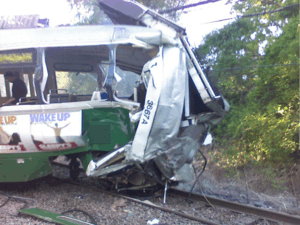
On May 28, 2008, two D branch trains collided in Newton. The operator of one of the trains was killed and numerous riders were taken to area hospitals with injuries of varying degrees of seriousness. While it was originally thought that cell phone use was responsible for the accident, the cause was officially determined to be an episode of micro-sleep caused by the driver's sleep apnea.[72]
On May 8, 2009, two trolleys rear-end collided underground between Park Street and Government Center when the driver of one of the trolleys, 24-year-old Aiden Quinn, was text messaging his girlfriend while driving.[73] Quinn had run through a red light before the crash, which injured 46 people. MBTA officials estimated that the cost of the crash was $9.6 million.[74] A strict ban on cell phone usage by MBTA operators was later enacted.[75]
On October 8, 2012, two E branch trolleys collided in the 700 block of Huntington Avenue near Brigham Circle when one derailed into the other, injuring three people including a train operator.[76] The next month on November 29, two trolleys collided at low speed at Boylston, injuring several dozen passengers.[77]
On March 10, 2014, a D branch trolley with passengers aboard derailed in the tunnel just west of Kenmore Station, near the flat junction between the "D" and "C" branches. A second train had to brake suddenly to avoid hitting the derailed train.[78] Ten people were treated for moderate injuries.[79]
On December 9, 2014, in the morning rush hour, a Type 7 trolley struck a pillar near Boylston and Park Streets, smashing the window and breaking off one of the panels of the two panel doors. Nobody on the train was injured.[80]
In October 2016, the Boston Globe reported that the Green Line had the highest number of derailments and accidents on light rail lines in the United States in 2015. The number of incidents had been increasing for several years due to deferred maintenance on tracks and wheels, which resulted in more low-speed derailments of Type 8 cars.[81]
References
- "Transit Ridership Report: Third Quarter 2019" (PDF). American Public Transportation Association. November 22, 2019.
- "Ridership and Service Statistics" (PDF) (14th ed.). Massachusetts Bay Transportation Authority. 2014.
- Booz • Allen & Hamilton Inc. (1995). "Applicability of Low-Floor Light Rail Vehicles in North America" (PDF). Transit Cooperative Research Program. Retrieved August 7, 2013.
- Most, Doug (January 26, 2014). "The bigger dig". Boston Globe. Retrieved January 22, 2016.
- Belcher, Jonathan. "Changes to Transit Service in the MBTA district" (PDF). NETransit.
- Sanborn, George M. (1992). A Chronicle of the Boston Transit System. Massachusetts Bay Transportation Authority – via MIT.
- "Curiosity Carcards" (PDF). Massachusetts Bay Transportation Authority.
- "Green Line extension breaks ground – for real, this time". BostonGlobe.com. Retrieved June 26, 2018.
- Malikova, Alexandra A. (June 2012). "MBTA Green Line 3-Car Train Operating Plans to Enhance Reliability and Capacity (Master's Thesis)" (PDF). Massachusetts Institute of Technology Department of Civil and Environmental Engineering. Retrieved August 7, 2013.
- Clarke, Bradley H. (2003). Streetcar Lines of the Hub – The 1940s. Boston Street Railway Association. ISBN 0938315056.
- "Roxbury–Dorchester–Mattapan Transit Needs Study" (PDF). Massachusetts Department of Transportation. September 2012. p. 53. Retrieved October 4, 2017.
- "The MBTA Vehicle Inventory Page". NETransit. Retrieved September 23, 2018.
- "Green Line Fleet (Type 7) Overhaul – Project Update and Final Engineering Services" (PDF). MBTA.com. December 10, 2018. Archived from the original (PDF) on December 15, 2018. Retrieved December 15, 2018.
- Diamant, Emanuel S.; et al. (Spring 1976). "Light Rail Transit : A State of the Art Review". United States Department of Transportation. Retrieved August 7, 2013.
- Thompson, Gregory L. (November 2003). "Defining an Alternative Future: Birth of the Light Rail Movement in North America" (PDF). Transportation Research Board. Retrieved August 7, 2013.
- "History: Light Rail Vehicle/Rapid Transit Car". Boeing. Retrieved August 7, 2013.
- Vuchic, Vukan R. (October 1972). Light Rail Transit Systems: A Definition and Evaluation (Report). Urban Mass Transportation Administration, US Department of Transportation. Retrieved December 20, 2018.
- Moore, Scott. "Boston's Green Line Crisis". NETransit. Archived from the original on April 6, 2004. Retrieved August 7, 2013.
- A Chronicle of the Boston Transit System. Massachusetts Bay Transportation Authority. 1981. p. 14 – via Internet Archive.
- "Boston – MBTA: Green Line – Technical Data" (PDF). Kinki-Sharyo. Archived from the original (PDF) on July 20, 2014. Retrieved August 7, 2013.
- Flint, Anthony. "MBTA Halts Purchase of Green Line 'Lemons'" (mirrored copy). The Boston Globe. December 12, 2004.
- Daniel, Mac (December 17, 2005). "Green Line seeks zippier service with upgrade plan". The Boston Globe. Archived from the original on January 25, 2007.CS1 maint: BOT: original-url status unknown (link), archived as of January 25, 2007
- "Bredas". The Boston Globe. December 14, 2006. Archived from the original on January 24, 2007.CS1 maint: BOT: original-url status unknown (link) archived as of January 24, 2007
- "End of the line for T pioneers". The Boston Globe. March 16, 2007. Retrieved August 7, 2013.
- Annear, Steve (November 18, 2014). "First of Refurbished Green Line Trolleys Heads Back Home". Boston. Retrieved November 25, 2014.
- Annear, Steve (May 13, 2014). "New Green Line Trains Will Hit the Tracks by 2017". Boston. Retrieved May 20, 2014.
- "CAF wins Boston Green Line order". Railway Gazette. May 16, 2014. Retrieved May 20, 2014.
- "Green Line Type 9 Project Update" (PDF). Massachusetts Bay Transportation Authority. March 27, 2017. p. 11.
- "New MBTA Green Line Car goes into Passenger Service" (Press release). Massachusetts Bay Transportation Authority. December 21, 2018.
- Brelsford, Laura (November 26, 2019). "SWA Initiatives—November 2019" (PDF). p. 12.
- Boroyan, Nate (January 16, 2014). "T Employees Work Through the Night Scrubbing Vandalized Trolleys". BostInno. Retrieved November 25, 2014.
- "No.1059 Boston Elevated Railway". Market Street Railway. Retrieved November 25, 2014.
- "MBTA > About the MBTA > Transit Projects > Transit Projects and Accessibility". Archived from the original on January 18, 2012. Retrieved October 23, 2018.
- Cudahy, Brian J. (1972). Change at Park Street Under; the story of Boston's subways. Brattleboro, Vt.: S. Greene Press. ISBN 0-8289-0173-2.
- Rocheleau, Matt (January 22, 2013). "MBTA: Mobile apps will be able to track Green Line trains by 2015". Boston Globe. Retrieved January 22, 2013.
- "CUSTOMERS ARE NOW ABLE TO TRACK GREEN LINE TRAINS" (Press release). Massachusetts Bay Transportation Authority. October 23, 2014. Retrieved October 28, 2014.
- "Green Line to nearly triple the number of 3-car trains" (Press release). Massachusetts Bay Transportation Authority. March 16, 2011.
- Vaccaro, Adam (May 3, 2016). "Why is the Green Line so crowded?". Boston Globe.
- "MBTA Capital Investment Program FY15-FY19" (PDF). MBTA. March 12, 2014. p. 124. Retrieved April 23, 2015.
- Bowles, Ian (July 30, 2010), Final Environmental Impact Report (PDF), p. 5, archived from the original (PDF) on July 8, 2011, retrieved October 16, 2010
- "Green Line Extension Project: Systemwide Stats and SUMMIT Results" (PDF). Green Line Extension Project: FY 2012 New Starts Submittal. Massachusetts Department of Transportation. January 2012. Retrieved January 27, 2015.
- Byrne, Matt (August 1, 2011). "State: Green Line extension will be delayed til 2018". boston.com (The Boston Globe). Retrieved August 1, 2011.
- Central Transportation Planning Staff (January 23, 2012). "Green Line Extension SIP Mitigation Inventory" (PDF). Massachusetts Department of Transportation. Retrieved June 26, 2012.
- Metzger, Andy. "Green Line Extension Cost Rises To $2 Billion". WBUR. Retrieved February 10, 2015.
- Mello, Mary Beth (June 11, 2012). "Re: Preliminary Engineering Approval for the Green Line Extension (GLX) Light Rail Transit Project" (PDF). Federal Transit Administration. Retrieved June 26, 2012.
- "Green Line Extension Phase 1 Construction Begins". Commonwealth Conversation: Transportation. Massachusetts Department of Transportation. December 11, 2012. Retrieved December 15, 2012.
- "Notice to Proceed Given For Phase 1 of Green Line Extension". Ward 5 Online. February 8, 2013. Retrieved February 8, 2013.
- Vaccaro, Adam (December 14, 2015). "Transit officials won't commit additional state money to Green Line extension". Boston Globe. Retrieved December 15, 2015.
- Interim Project Management Team Report: Green Line Extension Project – Report to the MBTA Fiscal and Management Control Board and the MassDOT Board of Directors Submitted May 9, 2016
- Vaccaro, Adam (May 13, 2019). "Somerville's getting a brand new bike path with the Green Line extension. Is it wide enough?". The Boston Globe.
- Dungca, Nicole (April 4, 2017). "Feds OK Green Line extension costs, securing project's future". Boston Globe. Retrieved April 5, 2017.
- Official Audit Report – Issued June 16, 2014: Massachusetts Bay Transportation Authority, For the period January 1, 2005 through December 31, 2012 (PDF) (Report). Auditor of the Commonwealth. June 16, 2014.
- "Executive Summary" (PDF). Program of Mass Transportation. Boston Regional Metropolitan Planning Organization. January 2004. p. 2-9. Archived from the original (PDF) on February 20, 2012.
- Ridership & Service Statistics (9 ed.). Massachusetts Bay Transportation Authority. 2004. p. 2.19 – via Internet Archive.
- "Planned Accessibility Projects – On Board the Green Line". Massachusetts Bay Transportation Authority. Archived from the original on August 10, 2004.
- Bierman, Noah (June 2, 2009). "Arlington T station reopens with disabled access". Boston Globe. Retrieved May 23, 2012.
- Rocheleau, Matt (September 14, 2010). "Copley station project nears end; historic church plans repairs". Boston Globe. Retrieved May 23, 2012.
- Moskowitz, Eric (April 25, 2010). "Kenmore station upgrades done, finally". Boston Globe. p. B2 – via Newspapers.com.

- "Trolley service to resume as project end". Boston Globe. November 3, 2011. Retrieved May 23, 2012.
- Moskowitz, Eric (March 21, 2016). "Government Center reopens". Boston Globe. Retrieved March 21, 2016.
- "MPO Agency Notes" (PDF). TRANSreport. Boston Region Metropolitan Planning Organization. April 2006 – via Internet Archive.
- Rocheleau, Matt (September 28, 2012). "MBTA to hold meeting on $20m project to rebuild Boston College Station". Boston Globe.
- "Access in Motion: 2009 Calendar" (PDF). Massachusetts Bay Transportation Authority. 2009. Archived from the original (PDF) on January 2, 2010.
- Brelsford, Laura (June 5, 2019). "SWA Initiatives—June 2019" (PDF). Massachusetts Bay Transportation Authority Department of System-Wide Accessibility. p. 2.
- Brown, Joel (August 29, 2019). "Comm Ave's $20.4M Makeover Nears Completion". BU Today.
- "MBTA installing underground tracking system for Green Line trolleys" (Press release). Massachusetts Bay Transportation Authority. March 3, 2015. Retrieved March 12, 2015.
- Annear, Steve (September 18, 2013). "The MBTA's Green Line Is Getting 'Next Train' Electronic Information Boards". Boston Magazine. Retrieved September 18, 2013.
- "Green Line's First Countdown Signs Go Live in Newton" (Press release). Massachusetts Bay Transportation Authority. April 24, 2015. Retrieved April 25, 2015.
- Roberts, Sarah (October 6, 2015). "Green Line to get countdown clocks in downtown stations". Boston Globe. Retrieved October 6, 2015.
- Levenson, Eric (January 20, 2016). "Why the Green Line's new countdown clocks measure 'stops away' instead of time". Boston Globe. Retrieved January 20, 2016.
- "Derailment disrupts Green Line E service". Boston Globe. August 23, 2014.
- Collision Between Two Massachusetts Bay Transportation Authority Green Line Trains, Newton, Massachusetts, May 28, 2008 (NTSB/RAR-09-02) (PDF) (Report). National Transportation Safety Board. July 14, 2009. Archived from the original (PDF) on October 16, 2011.
- "Trolley Driver Was Texting Girlfriend At Time Of Crash: 46 Injured In Green Line Crash" Archived February 22, 2012, at the Wayback Machine, WCVB, Boston, May 8, 2009.
- Texting Trolley Driver Is Transgendered Male, ABC News, May 11, 2009
- "Trolley Crash Inspires Tougher Cell Phone Policy: NTSB Still Investigating Crash" Archived February 22, 2012, at the Wayback Machine, WCVB, May 9, 2009
- "Accident involving two Green Line trolleys". www.wcvb.com. Retrieved October 8, 2012.
- Moskowitz, Erik; et al. (November 29, 2012). "35 taken to hospital after two trolleys collide at Boylston MBTA station". Boston Globe. Retrieved November 29, 2012.
- Tempera, Jacqueline; Martine Powers (March 10, 2014). "Seven injured as MBTA Green Line train derails near Kenmore Station". Boston.com. Retrieved March 11, 2014.
- "Green Line train derails; `it was intense'". Boston Herald. March 10, 2014. Retrieved March 10, 2014.
- Armstrong, Jim (December 9, 2014). "Door Torn Off Green Line Trolley Near Park Street Station". CBS 4 WBZ-TV. Archived from the original on November 28, 2017.
- Dungca, Nicole (October 13, 2016). "The Green Line had the most derailments in the nation last year". Boston Globe. Retrieved October 13, 2016.
External links
| Wikimedia Commons has media related to MBTA Green Line. |