Park Street station (MBTA)
Park Street is an MBTA transit station in Boston, Massachusetts. It is located at the intersection of Park Street and Tremont Street at the eastern edge of Boston Common in Downtown Boston. One of the two oldest stations on the "T" (the other is Boylston), Park Street is the transfer point between the Green and Red Lines, as one of the quartet of "hub stations" on the MBTA subway system. Park Street is the fourth-busiest station in the MBTA network, with an average of 19,836 entries each weekday in 2010.[1]
Park Street | |||||||||||||||||||||||||||||||
|---|---|---|---|---|---|---|---|---|---|---|---|---|---|---|---|---|---|---|---|---|---|---|---|---|---|---|---|---|---|---|---|
%2C_December_2019.JPG) A southbound Red Line train leaving Park Street station in 2019 | |||||||||||||||||||||||||||||||
| Location | Tremont Street and Park Street Boston, Massachusetts | ||||||||||||||||||||||||||||||
| Coordinates | 42.356389°N 71.0625°W | ||||||||||||||||||||||||||||||
| Owned by | MBTA | ||||||||||||||||||||||||||||||
| Line(s) | Cambridge Tunnel Tremont Street subway | ||||||||||||||||||||||||||||||
| Platforms | 2 island platforms, 1 side platform (Green Line) 1 island platform, 2 side platforms (Red Line) | ||||||||||||||||||||||||||||||
| Tracks | 4 (upper level - Green Line) 2 (lower level - Red Line) | ||||||||||||||||||||||||||||||
| Connections | via Winter Street Concourse to Downtown Crossing: | ||||||||||||||||||||||||||||||
| Construction | |||||||||||||||||||||||||||||||
| Platform levels | 2 | ||||||||||||||||||||||||||||||
| Disabled access | Yes | ||||||||||||||||||||||||||||||
| History | |||||||||||||||||||||||||||||||
| Opened | September 3, 1897 (upper level) March 23, 1912 (lower level) | ||||||||||||||||||||||||||||||
| Rebuilt | 1915, 1936, 1977-79, 1980s, 2004, 2012 | ||||||||||||||||||||||||||||||
| Traffic | |||||||||||||||||||||||||||||||
| Passengers (2013) | 19,653 (weekday average boardings)[1] | ||||||||||||||||||||||||||||||
| Services | |||||||||||||||||||||||||||||||
| |||||||||||||||||||||||||||||||
| |||||||||||||||||||||||||||||||
History
Initial construction
Tremont Street subway

The southern section of the Tremont Street subway from the Public Garden incline through Boylston to Park Street opened on September 1, 1897, followed on October 1 by the spur to the Pleasant Street Portal.[2] The station was built with 4 tracks serving 2 island platforms; these were connected by two loops, allowing streetcars from the south and west to reverse direction and return to the portals and surface routes.
On September 3, 1898, the tunnel was extended to Scollay Square, Adams Square, Haymarket Square, and the Canal Street Incline.[2] Some cars ran all the way through the tunnel on the outer tracks; others continued to loop at Park Street.
Boylston and Park Street were built with rectangular stone headhouses designed by Edmund M. Wheelwright that did not aesthetically match the Common. Unlike the interior decor, the headhouses were sharply criticized as "resembling mausoleums" and "pretentiously monumental".[3][4] Later stations on the East Boston Tunnel and Washington Street Tunnel used more modest headhouse designs in response to this criticism.[3]
Electric destination indicator boards were first installed at Park Street in 1899, replacing an announcer with a megaphone.[5][6]:22 Signalmen used metal picks to complete a circuit, lighting up a numeral indicating which berth the car arriving on a given route would stop at.[5]
Main Line Elevated

On June 10, 1901, the Main Line Elevated began running through the Tremont Street subway. The platforms at Park Street were retrofitted with raised wooden sections to allow elevated trains to run on the outer tracks to the Pleasant Street Portal, while streetcars continued to use the inner tracks and inner loop, entering the subway from the Public Garden incline.[2] This arrangement lasted until Main Line service was moved to a separate tunnel under parallel Washington Street. Elevated trains last ran through the tunnel on November 28, 1908; they moved to the Washington Street Tunnel on November 30, and streetcar service returned to all tracks on December 4.[2][7]
Cambridge Tunnel
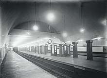
On March 23, 1912, the Cambridge Tunnel opened from Harvard Square to Park Street Under.[2] Park Street Under was built with two tracks with one side platform each and a center island platform, intended as a Spanish solution setup to speed boarding. Stairwells were added to the original platform level to connect to the lower level platforms. Unlike most other underground stations on the system (which were cut and cover construction with low ceilings), Park Street Under featured a spacious double-vaulted ceiling.
It was the first transfer station on the system to receive the "Under" postfix, rather than a separate name from the existing station. This represented a change in naming policy, and the first step towards easing wayfinding difficulties in the complex system.[8][9] North Station West (opened later in 1912), South Station Under (1916) and Scollay Under (1916) would later use this naming scheme.[10][11][12] Construction of the Dorchester Tunnel begun on May 3, 1912; the extension opened to Washington on April 4, 1915, and in three more segments to South Station Under in 1916, Broadway in 1917, and Andrew in 1918.[2]
Overcrowding had been a problem at Park Street since the Main Line was routed through it, and did not improve when it reverted to streetcar-only operations. The problem worsened with the influx of passengers transferring at Park Street Under, as the only entrances to those platforms were narrow staircases connecting through the streetcar level.[7] In preparation for the Boylston Street subway and the extension of the Cambridge Tunnel, the Boston Transit Commission substantially expanded the streetcar level. The platforms were extended to the south and straightened; the southbound platform was increased in area by one-half, and the northbound platform by three-eighths. The south headhouse of the southbound platform was moved south to the end of the expanded platform.[13][14] The construction work began on August 7, 1914, and was completed on March 8, 1915.[7][6]
Later changes
A loudspeaker system for announcements was added in 1921.[15] The Park Street Information Booth on the upper level, which soon became a Boston landmark, opened on December 15, 1923 and replaced an earlier kiosk in the same location.[6][16][17] On January 3, 1925, an explosion of celluloid film carried by a passenger injured dozens on a streetcar arriving at the station.[18]
Although the 1914–15 renovation increased the platform area, the narrow stairways to the lower level still impeded passenger flow. The stairway between the lower center platform and the upper northbound platform was replaced with a pair of stairways – one over the other – in a project that was completed in August 1921.[19][20][21] Widening of the stairs between the southbound platforms was completed on August 22, 1922.[22] The stairway between the upper southbound platform and the lower northbound platform was doubled in width, with the bottom half split into two sets in opposite directions.[23] That work – partially necessitated by capacity increases in the East Boston Tunnel – was completed on December 24, 1924.[24][25] Finally, widening of the stairs between the upper northbound platform and the lower southbound platform was completed on May 27, 1925.[26] These improvements reduced the amount of room available on the north ends of the streetcar platforms, and boarding areas were moved south.[7]
In July 1922, the Boston Transit Commission proposed the addition of a side platform adjacent to the outer northbound streetcar track, with a passageway under Tremont Street leading to two new entrances at Temple Place.[27] Opening the Winter Street Concourse to passengers was also proposed, but was soon rejected by the Department of Public Utilities in favor of continued use as storage space for adjacent businesses.[28] A more ambitious 1927 plan by one of the BERy trustees called for new side platforms on both sides of the streetcar level, with a sub-passage connecting the four streetcar platforms, as well as the Temple Place entrances and Winter Street passageway.[29]
In 1936, in response to still-persistent overcrowding, the Boston Transit Department constructed a new northbound side platform under Tremont Street with entrances at Temple Street. The project also added a sub-passage connecting the streetcar platforms and a passage connecting the new platform with the Cambridge Tunnel fare lobby opposite Park Street, but did not open the Winter Street Concourse.[30] The new platform moved the streetcar boarding area southbound for the second time. A new lighting system was also installed.[7] The project, funded by the Works Progress Administration, cost $407,000 (equivalent to $5.9 million in 2019).[30][31] Work began on January 8, 1936, and the new platform was opened on December 5.[6][30]
The 1947 state act that created the Metropolitan Transit Authority (MTA) from the Boston Elevated Railway established four immediate projects for the new agency, one of which was expansion of the Tremont Street subway to four tracks between Park Street and Scollay Square.[32] As part of the plan, Park Street and Boylston stations were to be combined into a single Boston Common station, with a direct entrance from an underground parking garage.[33] The garage ultimately opened in 1961, but the stations were not combined.[34] The south headhouse on the northbound side was removed in 1963.[35][7]:23
MBTA era

In 1964, the outer loop track was removed. Instead, a new crossover switch was installed to allow southbound streetcars from the through track to reach either side of the southbound platform.[7] There have been proposals to reconnect the outer loop, to allow trains on the outer inbound track to be turned around at Park Street, but this has not been done because of the cost of structural reinforcements that would now be required. A short stub "pit" track for emergency service remains within the inner loop. In 1966, the south headhouse on the southbound platform was converted to an information booth for the new Freedom Trail.[36][37]
In 1967, as part of a general system rebranding by the newly formed MBTA, the subway lines were assigned colors. The streetcar system—then down to five branches, and soon four—became the Green Line, the Cambridge-Dorchester Line became the Red Line, and the Main Line El became the Orange Line.[2] In the 1970s, the MBTA began allowing street musicians to play in the station.[38] Park Street was used as a filming location for See How She Runs (1978) and Spenser: For Hire (1985–88); the sitcom Park Street Under (1979) was set in a fictional bar inside the station.[38]
The late 1970s saw the first major renovations to the station in four decades. Plans were released for the modernization of Park Street and three other downtown stations on August 27, 1975.[39] A $3.6 million contract was awarded on December 1, 1976.[39] The 1936-built Temple Place entrance and passageway were closed that month, and concession stands were removed in 1977. The modernization included new wall tiles, new lighting, rebuilt staircases, and upgrades to the faregate area on the southbound platform.[7] Elevators to the fare lobby from the Red Line center platform and the surface were installed in 1979, making the Red Line section accessible.[40] However, the surface elevator was frequently out of service due to repairs and other construction in the station.[41] The aesthetics of the renovation were not well received; one longtime employee remarked the station resembled a billiard parlor.[38]
The Winter Street Concourse, an upper level of the Dorchester Tunnel between Park Street and Downtown Crossing, was cleared of some non-public storage and office space, and opened as a pedestrian connector in January 1979. It allows passengers to walk from the northbound Green Line side platform at Park Street to the southbound Orange Line platform at Downtown Crossing while remaining inside fare control.[7][6]
From August 1981 to June 22, 1996, additional peak-hour Red Line trains ran between Quincy Center station and Park Street, using crossovers north of Park Street to reverse direction. Between November 30, 1981 and June 1982, Park Street was also the northern terminus of a small number of five-car trains (the first Red Line trains longer than four cars), as station platforms to the north were not yet extended for longer trains.[2]
In the mid-1980s, the MBTA spent $80 million to extend the platforms of seven Red Line and three Orange Line stations to allow the use of six-car trains.[42] The agency obtained a $22 million federal grant in 1984 to partially fund the Central, Park Street, and Washington station work.[43] In 1985-86, the platforms at Park Street were extended to the north.[2][44] Six-car trains began operation on January 21, 1988.[2] The MBTA opened bidding for an additional round of construction in March 1991; a $6 million contract was issued on July 10.[45][46] The 1993-completed project included elevators to the Green Line sub-passage, completing elevator access to all platforms; however, Green Line trains were not yet accessible.[47][38] The northbound Green Line headhouse was exit-only until June 20, 1992, when it was converted to also serve as an entrance.[48] Around that time, a new south headhouse was built on the southbound side as the Freedom Trail information center was moved to a new structure nearby.[49]
Around 2000, the MBTA outfitted the Green Line platforms with portable lifts as a temporary accessibility measure to serve the new low-floor Type 8 streetcars.[50] A $15 million project to build raised low platforms at Park Street and Haymarket began in 2001.[51][52] The work at Park Street was done in segments to allow service to the station to continue during construction.[53] Construction was completed in 2003.[54] New elevators from the surface to the westbound Green Line unpaid lobby and from the westbound Green Line platform to the Red Line island platform opened on December 21, 2012.[55] In early 2019, the MBTA accepted bids for a $11.8 million renovation of Park Street station. The project includes replacement of all wayfinding signage and lighting, as well as the reopening of the 1976-closed Temple Place entrance.[56] The elevator between the Red Line lobby and platform will be replaced in 2022-2024 as part of accessibility improvements at Downtown Crossing.[57]
Station layout
Track Layout | |||||||||||||||||||||||||||||||||||||||||||||||||||||||||||||||||||||||||||||
|---|---|---|---|---|---|---|---|---|---|---|---|---|---|---|---|---|---|---|---|---|---|---|---|---|---|---|---|---|---|---|---|---|---|---|---|---|---|---|---|---|---|---|---|---|---|---|---|---|---|---|---|---|---|---|---|---|---|---|---|---|---|---|---|---|---|---|---|---|---|---|---|---|---|---|---|---|---|
Green Line | |||||||||||||||||||||||||||||||||||||||||||||||||||||||||||||||||||||||||||||
| |||||||||||||||||||||||||||||||||||||||||||||||||||||||||||||||||||||||||||||
Red Line | |||||||||||||||||||||||||||||||||||||||||||||||||||||||||||||||||||||||||||||
| |||||||||||||||||||||||||||||||||||||||||||||||||||||||||||||||||||||||||||||
Park Street is a bi-level station, with the Green Line running on the upper level and the Red Line on the lower level. The Green Line has four tracks numbered 1 to 4 (north to south). Tracks 1 and 2 serve an island platform for westbound trains. Tracks 3 and 4 serve an island platform for eastbound trains, with an additional side platform serving Track 4. Track 4 is used by all eastbound through trains; Track 3 is only used by trains terminating at Park Street, as it loops to rejoin Track 2. Both island platforms have headhouses and fare control areas on their northeast end; the westbound platform also has a headhouse at its southwest end. A sub-passage connects the middle of the three Green Line platforms. A passage from the eastbound side platform leads to a small fare lobby under Winter Street, with stairs to the surface and the Winter Street Concourse to Downtown Crossing.
The Red Line has two tracks: Track 5 southbound and Track 6 northbound. The Red Line has both island and side platforms; however, unlike the Spanish solution, all platforms are used for both boarding and alighting. Staircases connect each platform to both Green Line island platform and the fare lobby; exit-only escalators lead from the southern end of the side platforms to the surface. A backup control room for the subway system is located on the Green Line level over the middle of the Red Line platforms.[38]
| G | Street level | Exit/entrance, buses |
| B1 | Track 1 | ← Green Line ("C", "E" branches) toward Cleveland Circle or Heath Street (Boylston) |
| Island platform | ||
| Track 2 | ← Green Line ("B", "D" branches) toward Boston College or Riverside (Boylston) | |
| Track 3 | Green Line ("B" branch) termination track → | |
| Island platform | ||
| Track 4 | Green Line ("C", "E" branches) toward North Station (Government Center) → Green Line ("D" branch) toward Government Center (Terminus) → | |
| Side platform | ||
| Mezzanine | Winter Street Concourse to Downtown Crossing station | |
| B2 | Side platform | |
| Track 5 | ← Red Line toward Alewife (Charles/MGH) | |
| Island platform | ||
| Track 6 | Red Line toward Ashmont or Braintree (Downtown Crossing) → | |
| Side platform | ||
Park Street station is not a major bus transfer point, though MBTA Bus routes 43 and 55 (plus the single early-morning outbound trips of routes 191, 192, and 193) and several MVRTA commuter routes stop on Tremont Street at Temple Place.
Accessibility

Park Street station is accessible for passengers on all trains. Elevators connect the surface to the westbound Green Line platform, and to the fare lobby.[58] The Red Line center platform has elevators to the westbound Green Line platform and to the fare lobby; the Red Line side platforms are not accessible. Elevators also connect the westbound Green Line platform and the eastbound side platform to the sub-passage. Because there are no elevators connecting the Red Line with the southbound Orange Line at Downtown Crossing, the accessible route for that transfer uses the Winter Street Concourse and the elevator at Park Street.
Public art
There are several pieces of public art in the station. Celebration of the Underground by Lilli Ann K. Rosenberg is a large wall mosaic along the outer outbound (westbound) tracks at the Green Line level, and can be viewed from the outbound island platform. The mosaic commemorates the designation of the Tremont Street subway, including Park Street station, as a National Historic Landmark.[59] Created in 1978, it received renewed attention in 2020 after it was cleaned and better lit.[60]
Benedictions by Ralph Helmick consists of two giant bronze hands each mounted separately over the inbound and outbound Red Line tracks on the lower level of the station. Each hand is posed in a classic gesture of benediction or blessing.[61]
References
- "Ridership and Service Statistics" (PDF) (14th ed.). Massachusetts Bay Transportation Authority. 2014.
- Belcher, Jonathan. "Changes to Transit Service in the MBTA district" (PDF). NETransit.
- Coburn, Frederick W. (November 1910). "Rapid Transit and Civic Beauty". New Boston. Vol. 1 no. 7. pp. 307–314 – via Google Books.
- Rettig, Polly M. (June 14, 1976). "National Register of Historic Places Inventory – Nomination Form: Tremont Street Subway". National Park Service.
- "Signalmen of the Subway". Boston Globe. July 25, 1915. p. 25 – via Newspapers.com.

- Clarke, Bradley H. & Cummings, O.R. (1997). Tremont Street Subway: A Century of Public Service. Boston Street Railway Association. pp. 43, 49. ISBN 0938315048.
- Chasson, George Jr. (1987). Lonto, Arthur J. (ed.). "Boston's Main Line El: The Formative Years 1879-1908". Headlights. Electric Railroader's Association. 49: 22–23.
- O'Regan, Gerry (2012). "MBTA Red Line". nycsubway.org. David Pirmann.
- Cudahy, Brian J. (1972). Change at Park Street Under. Stephen Greene Press. p. 47. ISBN 0828901732. LCCN 72081531.
- "Few Used New Bowdoin Sq Tunnel Immediately After its Opening". Boston Globe. March 18, 1916. p. 14 – via Newspapers.com.
- "New Elevated Line to Open". Boston Globe. May 31, 1912. p. 18 – via Newspapers.com.
- ""South Station Under" Opens Tomorrow". Boston Globe. December 2, 1916. p. 16 – via Newspapers.com.
- "Will Use Part of the New Subway Sunday or Monday". Boston Globe. July 24, 1914. p. 9 – via Newspapers.com.
- "New Boylston St Subway". Boston Globe. July 23, 1914. pp. 1, 4 – via Newspapers.com. (second page)
- "Park-St Subway Station Now Has a Loud-Speaking Phone". Boston Globe. May 26, 1921. p. 1 – via Newspapers.com.
- "'L' Information Booth in Park St Station". Boston Globe. December 15, 1923. p. 18 – via Newspapers.com.
- Annual Report of the Public Trustees of the Boston Elevated Railway for the Year Ending December 31, 1923. Boston Elevated Railway. 1924. p. 8 – via Internet Archive.
- "Many Injured in Explosion on Car in Park-St Subway". Boston Globe. January 3, 1925. p. 1 – via Newspapers.com.
- Annual Report of the Transit Department for the Year Ending January 31, 1921. Boston Transit Department. 1921. p. 28 – via Internet Archive.
- Annual Report of the Transit Department for the Year Ending January 31, 1922. Boston Transit Department. 1922. p. 25 – via HathiTrust.
- "Open New Stairway at Park St This Week". Boston Globe. July 28, 1921. p. 7 – via Newspapers.com.
- Annual Report of the Transit Department for the Year Ending January 31, 1923. Boston Transit Department. 1923. p. 4 – via Internet Archive.
- Annual Report of the Transit Department for the Year Ending January 31, 1924. Boston Transit Department. 1924. pp. 30–31 – via Internet Archive.
- Annual Report of the Transit Department for the Year Ending January 31, 1925. Boston Transit Department. 1925. p. 38 – via HathiTrust.
- "Subway Changes at Park-St Station". Boston Globe. November 5, 1923. p. 14 – via Newspapers.com.
- Annual Report of the Transit Department for the Year Ending December 31, 1925. Boston Transit Department. 1926. p. 43–44 – via Internet Archive.
- "Plan to Alleviate Park St Congestion". Boston Globe. July 30, 1922. p. 12 – via Newspapers.com.
- "Foot Passage Under Tremont St for Subway Car Passengers". Boston Globe. October 24, 1922. p. 14 – via Newspapers.com.
- "O'Hare Plan for Park-St Station Designed to End Jams both on Street and in Subway". Boston Globe. December 14, 1927. p. 17 – via Newspapers.com.
- Eighteenth Annual Report of the Board of Trustees of the Boston Elevated Railway Company for the Year Ending December 31, 1936. Boston Elevated Railway. 1937. p. 16 – via Internet Archive.
- Thomas, Ryland; Williamson, Samuel H. (2019). "What Was the U.S. GDP Then?". MeasuringWorth. Retrieved April 6, 2019. United States Gross Domestic Product deflator figures follow the Measuring Worth series.
- "Chapter 544: An act providing for the creation of the Metropolitan Transit Authority and the acquisition and operation by it of the entire assets, property and franchises of the Boston Elevated Railway Company". Acts and Resolves passed by the General Court of Massachusetts in the year 1947. Secretary of the Commonwealth. June 19, 1947. pp. 539–556 – via Internet Archive.
- "You May Be Getting Off and On Subway Cars at Boston Common Station". Boston Globe. June 20, 1948. p. 92 – via Newspapers.com. (second page)
- "Boston Common Garage to Be World's Biggest". Boston Globe. November 17, 1961. p. 20 – via Newspapers.com.
- "MTA Duel Proves Clinker". Boston Globe. August 16, 1962. p. 10 – via Newspapers.com.
- "Buy a Piece of Freedom Trail". Boston Globe. February 6, 1966. p. 78 – via Newspapers.com.
- Cohen, Cathleen (October 2, 1966). "Freedom Trail Booth A Multi-Purpose Room". Boston Globe. p. 16 – via Newspapers.com.
- "Park Street Station". Boston Globe Calendar. August 27, 1992. pp. 12, 13 – via Newspapers.com. (second page)
- Sanborn, George M. (1992). A Chronicle of the Boston Transit System. Massachusetts Bay Transportation Authority. Archived from the original on April 16, 2019 – via Massachusetts Institute of Technology.
- 1979 Annual Report. Massachusetts Bay Transportation Authority. 1979. p. 27 – via Internet Archive.
- Ackerman, Jerry (March 8, 1989). "T pressured to open all routes to disabled". Boston Globe. pp. 1, 16 – via Newspapers.com. (second page, third page)
- 1985 Annual Report. Massachusetts Bay Transportation Authority. 1985. p. 13 – via Internet Archive.
- 1984 Annual Report. Massachusetts Bay Transportation Authority. 1984. p. 22 – via Internet Archive.
- 1986 Annual Report. Massachusetts Bay Transportation Authority. 1986. p. 23 – via Internet Archive.
- "Legal Notices". Boston Globe. March 12, 1991. p. 68 – via Newspapers.com.
- "Field narrowed to 3 finalists for MBTA post". Boston Globe. July 11, 1991. p. 51 – via Newspapers.com.
- Tran Systems and Planners Collaborative (August 24, 2007). "Evaluation of MBTA Paratransit and Accessible Fixed Route Transit Services: Final Report" (PDF). Massachusetts Bay Transportation Authority.
- Cullen, Kevin (June 23, 1992). "City Scenes". Boston Globe. p. 21 – via Newspapers.com.
- Howe, Peter J. (March 3, 1990). "Plan razed for center on Common". Boston Globe. p. 21 – via Newspapers.com.
- "Executive Summary" (PDF). Program of Mass Transportation. Boston Regional Metropolitan Planning Organization. January 2004. p. 2-9. Archived from the original (PDF) on February 20, 2012.
- "U.S. Government Procurements". Commerce Business Daily. No. PSA-2843. May 8, 2001. p. 17 – via Google Books.
- "Planned Accessibility Projects - On Board the Green Line". Massachusetts Bay Transportation Authority. Archived from the original on August 10, 2004.
- "MBTA Continues Light Rail Accessibility Program at Park Street Station" (Press release). Massachusetts Bay Transportation Authority. March 13, 2003. Archived from the original on April 17, 2003.
- "Light Rail Accessibility Program at Park Street Station Approaches Completion" (Press release). Massachusetts Bay Transportation Authority. July 25, 2003. Archived from the original on August 3, 2003.
- Smith, Kelly (December 21, 2012). "New elevators for America's first subway station" (Press release). Massachusetts Bay Transportation Authority.
- "Notice to Bidders" (PDF). Park Street Station Wayfinding and Station Improvements. Massachusetts Bay Transportation Authority. January 23, 2019.
- McCormack, John (March 23, 2020). "MBTA Contract No. A90PS01: Engineering and Design Services for the MBTA Downtown Crossing Station Accessibility Improvements Project, Phase II" (PDF). Massachusetts Bay Transportation Authority.
- "Park Street Station Neighborhood Map" (PDF). Massachusetts Bay Transportation Authority. April 2012. Archived from the original (PDF) on July 17, 2014.
- "On the Green Line" (PDF). Massachusetts Bay Transportation Authority.
- Annear, Steve (March 5, 2020). "MBTA sheds new light on Park Street station mural". Boston Globe.
- "On the Red Line" (PDF). Massachusetts Bay Transportation Authority.
External links
| Wikimedia Commons has media related to Park Street station. |
- MBTA - Park Street
- Park Street entrance from Google Maps Street View
- West Street entrance from Google Maps Street View
| Public art | |
|---|---|