Fenway station
Fenway is a light rail stop on the MBTA Green Line D branch, located under Park Drive near the Riverway in the Fenway–Kenmore neighborhood of Boston, Massachusetts. It opened along with the rest of the D Branch on July 4, 1959, when trolleys replaced Highland Branch commuter rail service. The station is fully handicapped accessible from Park Drive via the Landmark Center parking lot as well as from Miner Street.
Fenway | |||||||||||
|---|---|---|---|---|---|---|---|---|---|---|---|
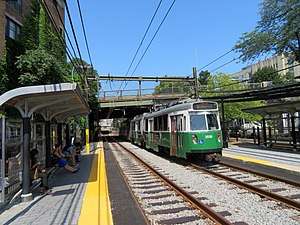 An inbound train at Fenway station in July 2019 | |||||||||||
| Location | Park Drive near The Riverway Boston, Massachusetts | ||||||||||
| Coordinates | 42°20′42.15″N 71°6′17.37″W | ||||||||||
| Owned by | MBTA | ||||||||||
| Line(s) | Highland Branch | ||||||||||
| Platforms | 2 side platforms | ||||||||||
| Tracks | 2 | ||||||||||
| Connections | |||||||||||
| Construction | |||||||||||
| Bicycle facilities | 18 spaces | ||||||||||
| Disabled access | Yes | ||||||||||
| History | |||||||||||
| Opened | July 4, 1959[1] | ||||||||||
| Previous names | Fenway Park | ||||||||||
| Traffic | |||||||||||
| Passengers (2011) | 3,488 (weekday average boardings)[2] | ||||||||||
| Services | |||||||||||
| |||||||||||
Named after the Fenway parkway rather than Fenway Park, it is not the nearest station to the stadium—Lansdowne commuter rail and Kenmore Green Line station are closer. Nevertheless, it is heavily used during Boston Red Sox home games and other Fenway Park events.
History
The Boston and Worcester Railroad opened a 1.4-mile (2.3 km) branch from Brookline Junction to Brookline on April 10, 1848.[3] The Charles River Branch Railroad extended the Brookline Branch to Newton Upper Falls in November 1852 and to Needham in June 1853, keeping the original B&W station for its service.[3][4]
The Boston and Albany Railroad bought back the line, then part of the New York and New England Railroad, in February 1883. It was double-tracked and extended to the B&A main at Riverside; "Newton Circuit" service via the Highland Branch and the main line began on May 16, 1886.[3] No station was located at what is now Park Drive; the nearest stations were Chapel and later Longwood to the west.[4]
In June 1957, the Massachusetts Legislature approved the purchase of the branch by the M.T.A. from the nearly-bankrupt New York Central Railroad for conversion to a trolley line. Service ended on May 31, 1958.[3] The line was quickly converted for trolley service and reopened on July 4, 1959.[1] All pre-1958 station locations were kept (though many station buildings were demolished for parking lots) and a new Fenway Park station was added at Park Drive.[5]

In the mid-1970s, the MBTA began calling the station Fenway after the road of the same name in the 1970s, as it is significantly further from Fenway Park than Kenmore station; however, the old name was used on some maps into the 1980s.[6][7] Until the 2006 season, it remained well-trafficked by fans from Red Sox games because the MBTA did not collect fares at outbound Green Line surface stops, making the trip to Riverside free for those boarding at Fenway but not at Kenmore. At the beginning of 2007, the MBTA started collecting fares on outbound trips and the station's popularity declined.[8] However, some fans still use the station either due to confusion or to avoid crowding at Kenmore.
In the early 2000s, the MBTA modified key surface stops with raised platforms for accessibility as part of the Light Rail Accessibility Program. The renovation of Fenway was completed around 2002.[9][10] In June 2007, the MBTA constructed a new siding at Fenway station to store maintenance equipment.
Fenway station was a proposed stop on the MBTA's proposed Urban Ring Project.[11] The Urban Ring was to be a Bus Rapid Transit (BRT) Line designed to connect the current MBTA Lines to reduce strain on the downtown stations. Under the most recent plan, the line would have run under the D branch near Fenway in a bored tunnel, with an underground station at Fenway.[12] The Urban Ring project is currently shelved due to the MBTA's financial difficulties.
Station layout
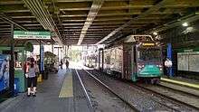
The station is located under the Park Drive overpass, with platforms stretching under the bridge and slightly to the west. A set of stairs connects the inbound platform to the bridge. Accessible sidewalks connect the inbound platform to Park Drive via the Landmark Center parking lot and to Miner Street next to the tracks. The outbound platform has no entrances of its own and is accessed via pedestrian crossings from the inbound platform.
Around 2016, the MBTA is considered adding one or two elevators to improve accessibility at the station, but it was not pursued.[13]
| G | Street level | Exit/entrance, buses |
| P Platform level |
Side platform | |
| Westbound | ← Green Line toward Riverside (Longwood) | |
| Eastbound | Green Line toward Government Center (Kenmore) → | |
| Side platform | ||
MBTA Bus routes CT2 and 47 run on Park Drive, with stops on the bridge above the station.[14] There are no crosswalks to access the southbound bus stop at the station; the nearest crosswalks are at Riverway.
References
- Belcher, Jonathan. "Changes to Transit Service in the MBTA district" (PDF). NETransit. p. 290. Page numbers are accurate to the April 21, 2018 version.
- "Ridership and Service Statistics" (PDF) (14th ed.). Massachusetts Bay Transportation Authority. 2014.
- Humphrey, Thomas J.; Clark, Norton D. (1985). Boston's Commuter Rail: The First 150 Years. Boston Street Railway Association. pp. 21–24. ISBN 9780685412947.
- Karr, Ronald Dale (1995). The Rail Lines of Southern New England. Branch Line Press. pp. 277, 288–289. ISBN 0942147022.
- Lufkin, Richard F. (1959), Metropolitan Transit Authority System Route Map, Metropolitan Transit Authority – via Wikimedia Commons
- "Transportation Map: Fourth Edition". Massachusetts Bay Transportation Authority. Summer 1976 – via Ward Maps.
- "System Route Map". Massachusetts Bay Transportation Authority. 1988 – via Ward Maps.
- Waltz, Vicky (11 November 2006). "End of the Line for Free T". BU Today. Retrieved 1 July 2012.
- "Subway Service". Ridership and Service Statistics. Massachusetts Bay Transportation Authority. October 2003. p. 2.19 – via Internet Archive.
- "Executive Summary" (PDF). Program of Mass Transportation. Boston Regional Metropolitan Planning Organization. January 2004. p. 2-9. Archived from the original (PDF) on February 20, 2012.
- "Urban Ring Phase 2 FACT SHEET" (PDF). January 2009. Archived from the original (PDF) on 8 July 2011.
- "The Urban Ring Phase 2: Revised Draft Environmental Impact Report/Statement" (PDF). Massachusetts Executive Office of Transportation. November 2008. Retrieved 7 November 2015.
- Brelsford, Laura (December 5, 2016). "MBTA System-Wide Accessibility Initiatives: December 2016 Update" (PDF). Massachusetts Bay Transportation Authority Department of System-Wide Accessibility. p. 10.
- "Fenway Station Neighborhood Map" (PDF). Massachusetts Bay Transportation Authority. October 2011. Retrieved 7 November 2015.
External links
| Wikimedia Commons has media related to Fenway station. |