Green Line E branch
The E branch (also referred to as the Huntington Avenue branch, or formerly as the Arborway branch) is a streetcar line in the Boston, Massachusetts area, operating as a branch of the Massachusetts Bay Transportation Authority Green Line. From 1985 to 2011, service beyond Heath Street to the original outbound terminus at Arborway was "temporarily" suspended, with the route 39 bus providing service beyond; service restoration was officially canceled in 2011 after the defeat of a lawsuit. The segment of the line between Brigham Circle and Heath Street is the only remaining section of street-running tracks in revenue use by the MBTA; all other trackage is in tunnels and bridges, on private rights-of-way, in reserved medians, or is used for out-of-service trains (near Cleveland Circle).
| Green Line E branch | |||||||||||||||||||||||||||||||||||||||||||||||||||||||||||||||||||||||||||||||||||||||||||||||||||||||||||||||||||||||||||||||||||||||||||||||||||||||||||||||||||||||||||||||||||||||||||||||||||||||||||||||||||||||||||||||||||||||||||||||||||||||||||||||||||||||||||||||||||||||||||||||||||||||||||||||||||||||||||||||||||||||||||
|---|---|---|---|---|---|---|---|---|---|---|---|---|---|---|---|---|---|---|---|---|---|---|---|---|---|---|---|---|---|---|---|---|---|---|---|---|---|---|---|---|---|---|---|---|---|---|---|---|---|---|---|---|---|---|---|---|---|---|---|---|---|---|---|---|---|---|---|---|---|---|---|---|---|---|---|---|---|---|---|---|---|---|---|---|---|---|---|---|---|---|---|---|---|---|---|---|---|---|---|---|---|---|---|---|---|---|---|---|---|---|---|---|---|---|---|---|---|---|---|---|---|---|---|---|---|---|---|---|---|---|---|---|---|---|---|---|---|---|---|---|---|---|---|---|---|---|---|---|---|---|---|---|---|---|---|---|---|---|---|---|---|---|---|---|---|---|---|---|---|---|---|---|---|---|---|---|---|---|---|---|---|---|---|---|---|---|---|---|---|---|---|---|---|---|---|---|---|---|---|---|---|---|---|---|---|---|---|---|---|---|---|---|---|---|---|---|---|---|---|---|---|---|---|---|---|---|---|---|---|---|---|---|---|---|---|---|---|---|---|---|---|---|---|---|---|---|---|---|---|---|---|---|---|---|---|---|---|---|---|---|---|---|---|---|---|---|---|---|---|---|---|---|---|---|---|---|---|---|---|---|---|---|---|---|---|---|---|---|---|---|---|---|---|---|---|---|---|---|---|---|---|---|---|---|---|---|---|---|---|---|---|---|---|---|---|---|---|---|---|---|---|---|---|---|---|---|---|---|---|---|---|
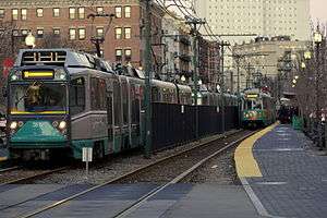 E branch trains at Northeastern University station in 2008 | |||||||||||||||||||||||||||||||||||||||||||||||||||||||||||||||||||||||||||||||||||||||||||||||||||||||||||||||||||||||||||||||||||||||||||||||||||||||||||||||||||||||||||||||||||||||||||||||||||||||||||||||||||||||||||||||||||||||||||||||||||||||||||||||||||||||||||||||||||||||||||||||||||||||||||||||||||||||||||||||||||||||||||
| Overview | |||||||||||||||||||||||||||||||||||||||||||||||||||||||||||||||||||||||||||||||||||||||||||||||||||||||||||||||||||||||||||||||||||||||||||||||||||||||||||||||||||||||||||||||||||||||||||||||||||||||||||||||||||||||||||||||||||||||||||||||||||||||||||||||||||||||||||||||||||||||||||||||||||||||||||||||||||||||||||||||||||||||||||
| Type | Light rail | ||||||||||||||||||||||||||||||||||||||||||||||||||||||||||||||||||||||||||||||||||||||||||||||||||||||||||||||||||||||||||||||||||||||||||||||||||||||||||||||||||||||||||||||||||||||||||||||||||||||||||||||||||||||||||||||||||||||||||||||||||||||||||||||||||||||||||||||||||||||||||||||||||||||||||||||||||||||||||||||||||||||||||
| System | Green Line | ||||||||||||||||||||||||||||||||||||||||||||||||||||||||||||||||||||||||||||||||||||||||||||||||||||||||||||||||||||||||||||||||||||||||||||||||||||||||||||||||||||||||||||||||||||||||||||||||||||||||||||||||||||||||||||||||||||||||||||||||||||||||||||||||||||||||||||||||||||||||||||||||||||||||||||||||||||||||||||||||||||||||||
| Locale | Boston | ||||||||||||||||||||||||||||||||||||||||||||||||||||||||||||||||||||||||||||||||||||||||||||||||||||||||||||||||||||||||||||||||||||||||||||||||||||||||||||||||||||||||||||||||||||||||||||||||||||||||||||||||||||||||||||||||||||||||||||||||||||||||||||||||||||||||||||||||||||||||||||||||||||||||||||||||||||||||||||||||||||||||||
| Termini | North Station Heath Street | ||||||||||||||||||||||||||||||||||||||||||||||||||||||||||||||||||||||||||||||||||||||||||||||||||||||||||||||||||||||||||||||||||||||||||||||||||||||||||||||||||||||||||||||||||||||||||||||||||||||||||||||||||||||||||||||||||||||||||||||||||||||||||||||||||||||||||||||||||||||||||||||||||||||||||||||||||||||||||||||||||||||||||
| Stations | 17 | ||||||||||||||||||||||||||||||||||||||||||||||||||||||||||||||||||||||||||||||||||||||||||||||||||||||||||||||||||||||||||||||||||||||||||||||||||||||||||||||||||||||||||||||||||||||||||||||||||||||||||||||||||||||||||||||||||||||||||||||||||||||||||||||||||||||||||||||||||||||||||||||||||||||||||||||||||||||||||||||||||||||||||
| Operation | |||||||||||||||||||||||||||||||||||||||||||||||||||||||||||||||||||||||||||||||||||||||||||||||||||||||||||||||||||||||||||||||||||||||||||||||||||||||||||||||||||||||||||||||||||||||||||||||||||||||||||||||||||||||||||||||||||||||||||||||||||||||||||||||||||||||||||||||||||||||||||||||||||||||||||||||||||||||||||||||||||||||||||
| Opened | February 16, 1941[1] | ||||||||||||||||||||||||||||||||||||||||||||||||||||||||||||||||||||||||||||||||||||||||||||||||||||||||||||||||||||||||||||||||||||||||||||||||||||||||||||||||||||||||||||||||||||||||||||||||||||||||||||||||||||||||||||||||||||||||||||||||||||||||||||||||||||||||||||||||||||||||||||||||||||||||||||||||||||||||||||||||||||||||||
| Operator(s) | MBTA | ||||||||||||||||||||||||||||||||||||||||||||||||||||||||||||||||||||||||||||||||||||||||||||||||||||||||||||||||||||||||||||||||||||||||||||||||||||||||||||||||||||||||||||||||||||||||||||||||||||||||||||||||||||||||||||||||||||||||||||||||||||||||||||||||||||||||||||||||||||||||||||||||||||||||||||||||||||||||||||||||||||||||||
| Character | Underground (Symphony and eastward) Median ROW (Northeastern to Brigham Circle) Street-running (Brigham Circle to Heath Street) | ||||||||||||||||||||||||||||||||||||||||||||||||||||||||||||||||||||||||||||||||||||||||||||||||||||||||||||||||||||||||||||||||||||||||||||||||||||||||||||||||||||||||||||||||||||||||||||||||||||||||||||||||||||||||||||||||||||||||||||||||||||||||||||||||||||||||||||||||||||||||||||||||||||||||||||||||||||||||||||||||||||||||||
| Rolling stock | Kinki Sharyo Type 7 Ansaldobreda Type 8 | ||||||||||||||||||||||||||||||||||||||||||||||||||||||||||||||||||||||||||||||||||||||||||||||||||||||||||||||||||||||||||||||||||||||||||||||||||||||||||||||||||||||||||||||||||||||||||||||||||||||||||||||||||||||||||||||||||||||||||||||||||||||||||||||||||||||||||||||||||||||||||||||||||||||||||||||||||||||||||||||||||||||||||
| Technical | |||||||||||||||||||||||||||||||||||||||||||||||||||||||||||||||||||||||||||||||||||||||||||||||||||||||||||||||||||||||||||||||||||||||||||||||||||||||||||||||||||||||||||||||||||||||||||||||||||||||||||||||||||||||||||||||||||||||||||||||||||||||||||||||||||||||||||||||||||||||||||||||||||||||||||||||||||||||||||||||||||||||||||
| Line length | 4.3 miles (6.9 km) | ||||||||||||||||||||||||||||||||||||||||||||||||||||||||||||||||||||||||||||||||||||||||||||||||||||||||||||||||||||||||||||||||||||||||||||||||||||||||||||||||||||||||||||||||||||||||||||||||||||||||||||||||||||||||||||||||||||||||||||||||||||||||||||||||||||||||||||||||||||||||||||||||||||||||||||||||||||||||||||||||||||||||||
| Number of tracks | 2 | ||||||||||||||||||||||||||||||||||||||||||||||||||||||||||||||||||||||||||||||||||||||||||||||||||||||||||||||||||||||||||||||||||||||||||||||||||||||||||||||||||||||||||||||||||||||||||||||||||||||||||||||||||||||||||||||||||||||||||||||||||||||||||||||||||||||||||||||||||||||||||||||||||||||||||||||||||||||||||||||||||||||||||
| Track gauge | 4 ft 8 1⁄2 in (1,435 mm) | ||||||||||||||||||||||||||||||||||||||||||||||||||||||||||||||||||||||||||||||||||||||||||||||||||||||||||||||||||||||||||||||||||||||||||||||||||||||||||||||||||||||||||||||||||||||||||||||||||||||||||||||||||||||||||||||||||||||||||||||||||||||||||||||||||||||||||||||||||||||||||||||||||||||||||||||||||||||||||||||||||||||||||
| |||||||||||||||||||||||||||||||||||||||||||||||||||||||||||||||||||||||||||||||||||||||||||||||||||||||||||||||||||||||||||||||||||||||||||||||||||||||||||||||||||||||||||||||||||||||||||||||||||||||||||||||||||||||||||||||||||||||||||||||||||||||||||||||||||||||||||||||||||||||||||||||||||||||||||||||||||||||||||||||||||||||||||
Northeast of the street-running section, the tracks run in the median of Huntington Avenue before descending via the Northeastern incline into the Huntington Avenue subway. Just west of Copley station, an underground flat junction connects the line into the other Green Line branches in the Boylston Street subway, where they all run together to downtown.
As of May 2020, the E branch terminates at North Station. It will be extended to Union Square in 2021 as part of the Green Line Extension.
History
Horsecar lines
What became the E branch was formed from portions of several streetcar lines. The first of these was the West Roxbury Railroad, a horsecar line opened on November 14, 1857 in what was then West Roxbury.[2][3]:60 It ran from Roxbury Crossing to Jamaica Plain along Lowell Street (now Columbus Avenue), Centre Street, and South Street.[4] The line was quickly leased by the Metropolitan Railroad, which operated through service between Jamaica Plain and downtown Boston using its line on Tremont Street. Travel time for the 4 1⁄2-mile (7.2 km)-long line was over an hour with a ten-cent fare.[3]:60 A two-track carhouse with a waiting room was located at the terminus of the line at Jamaica Street in Jamaica Plain.[5]:10 (The Metropolitan's main carhouse and barn was located at Roxbury Crossing.)[5]:10 In 1858, the Metropolitan opened a connector between Lowell Street and John Eliot Square, allowing Jamaica Plain cars to also use the Washington Street line (via Dudley Square) to reach downtown. The railroad also rebuilt the Jamaica Plain line that year to accommodate heavier ridership, including the double-tracking of some portions.[5]:10
On August 1, 1859, the Metropolitan was granted permission to add a 1.6-mile (2.6 km)-long branch to School Street (northwest of Brookline Village) along what was then called Washington Street.[6][5]:11 (It was soon renamed as Tremont Street east of Brookline Village; the portion between Brigham Circle and Brookline Village was renamed again as part of Huntington Avenue in 1895.) The line opened on October 26, 1859.[7] Permission to double-track the line was given on September 9, 1879.[5]:11 The portion west of Brookline Village may have been intermittently operated.[8]
As the west part of the Back Bay was filled, Huntington Avenue became a major thoroughfare. The Metropolitan received rights to construct a double-track line on Huntington from Copley Square (where it connected to the existing Marlborough Street line) to West Chester Park (later renamed Massachusetts Avenue) on March 18, 1881.[5]:11 The 0.7-mile (1.1 km) line opened by that September, serving the exhibitions at the Mechanics Hall and New England Fair Building.[9] A 1.2-mile (1.9 km) extension along the newly-laid-out section of Huntington from West Chester Park to Brigham Circle was granted on October 29, 1883; its opening on October 1, 1884 completed a second Brookline–Boston route.[5]:11[8][10] A 1.2-mile (1.9 km) branch along Longwood Avenue to Coolidge Corner opened around late 1884.[11][12] Around 1888, a 0.8-mile (1.3 km) branch was opened west from Brookline Village on Boylston Street and Cypress Street, serving the Pill Hill area.[13][14][15] (This may have been to compete with the Boston and Albany Railroad, which had begun its Newton Circuit service through Brookline in 1886.[16])
Electrification
In November 1887, the Metropolitan was merged into the West End Street Railway as it consolidated the various Boston street railways into a unified system.[17] After the successful electrification of the Beacon Street line in 1888–89, the West End quickly moved to electrify its entire system.[3]:57 The Jamaica Plain–Northern Depots line was concerted to electric operation on October 14, 1891, followed by other Tremont Street lines on October 22.[18][19] The horsecar barn at Jamaica Plain was replaced with a new structure for the electric cars; in early 1901, it was in turn replaced by a 320-by-325-foot (98 m × 99 m) carhouse with a passenger waiting room and space for 150 streetcars.[20][5]:10–11
The West End electrified its Huntington Avenue line in 1893–94. Work was completed by mid-July 1894 except for a short stretch near the Riverway.[21] On August 4, all Brookline service via Huntington Avenue was converted to electric operation. This included the Washington Street branch (extended to Park Street), the Cypress Street branch, and the Tremont Street tracks to Roxbury Crossing.[22][3]:61 The Washington Street branch was extended to Beacon Street at Washington Square on September 1, allowing through service between Reservoir via Brookline Village.[23] On August 15, 1896, an extension of the Beacon Street line opened on Chestnut Hill Avenue and Commonwealth Avenue to Lake Street.[24] Reservoir service via Brookline Village was extended to Lake Street, where a connection was made with the Commonwealth Avenue Street Railway.[3]:58
In November 1894, the Cypress Street branch was extended slightly to the new Cypress Street carhouse, which housed 36 streetcars.[25][26] The carhouse was expanded in 1897, with a new capacity around 79 cars.[25] Electrification of the Longwood Avenue branch was after the other Huntington Avenue branches, completed in 1894 or 1895.[22][27] Only the Boston portion of the branch was electrified (possibly owing to the deteriorated bridge over the Muddy River and the Highland Branch, which was replaced in 1897–98[28]); in September 1894, Brookline directed the West End to remove the Longwood Avenue tracks west of the town line.[29] In 1894–96, the city paved Huntington Avenue as a boulevard, with the streetcar tracks moved into a dedicated median east of Brigham Circle.[30][31][32]
The first section of the Tremont Street subway opened on September 1, 1897. Among the lines immediately routed into the subway using the Public Garden incline were the Cypress Street via Huntington Avenue and Jamaica Plain crosstown via Huntington Avenue lines.[33] The southern subway section to the Pleasant Street incline opened on September 30, and Jamaica Plain cars via Tremont Street were routed into the subway.[34][3]:23 Reservoir service via Huntington Avenue was added to the subway on November 8.[35] Longwood Avenue cars and Lake Street via Huntington Avenue cars soon used the subway as well.[3]:22 Other early services also used Huntington Avenue east of Massachusetts Avenue, including a Forest Hills–Park Street route via Washington Street (introduced on November 1, 1898) and a Humboldt Avenue–East Boston Ferries route.[3]:61[36]
Expansion
Two connecting routes opened in August 1900. New tracks on Harvard Street from Brookline Village to Coolidge Corner allowed through service from Allston to the subway via Huntington Avenue. The Ipswich Street line provided an additional route between Brookline Village and the subway; service on that line initially ran to Cypress Street.[37] Service using the Ipswich Street line was extended west on Boylston Street from Cypress Street to the Newton line at Chestnut Hill later in 1900.[38] Through service on the Longwood Avenue branch ended on August 8, 1901; it became a Brookline Avenue–Huntington Avenue shuttle.[36] On May 5, 1903, the Boston and Worcester Street Railway (B&W) began operations; east of Chestnut Hill, it used the BERy tracks on Boylston Street and Huntington Avenue.[39]
The Main Line Elevated opened between Dudley Square and Sullivan Square on June 10, 1901. The Main Line used the outer tracks of the Tremont Street subway (the Pleasant Street incline tracks) and provided a significantly faster route to downtown that surface streetcars, prompting a rearrangement of the streetcar network. Jamaica Plain service was rerouted to the Dudley Square transfer station; a new Dudley–Brookline route was introduced soon after.[40][41] Tracks on South Street between Jamaica Plain and Forest Hills Square (and the adjacent Forest Hills Yard) were approved by the city in June 1900.[42] Construction did not begin until April 1902, and the connector opened on May 17.[43][3]:61 The BERy opened tracks on the newly-laid-out South Huntington Avenue between Centre Street and Huntington Avenue on May 11, 1903, and began running Jamaica Plain–Park Street service via South, Centre, South Huntington, and Huntington.[44][3]:61
By 1907, regular service on Huntington Avenue west of Massachusetts Avenue included cars from Jamaica Plain via South Huntington Avenue, Lake Street (with some Reservoir short turns) via Washington Street, Oak Square via Harvard Street, and Allston Carhouse via Harvard Street, all entering the subway and looping at Park Street; as well as Cypress Street–Dudley cars and B&W cars. (A number of additional routes continued to use Huntington Avenue east of Massachusetts Avenue.) Additional routes used the tracks on South Street and Center Street in Jamaica Plain, including Forest Hills–Park Street (via Columbus Avenue), Jamaica Plain Carhouse–Dudley, and Jamaica Plain–Sullivan Square.[45]:20–21 On November 30, 1908, Main Line trains were rerouted into the Washington Street Tunnel; the outer Tremont Street subway tracks and the Pleasant Street Incline reopened to streetcars on December 4, with some lines extended or rerouted from Dudley. Streetcars entering the subway on Boylston Street continued to loop at Park Street; those entering at Pleasant Street (including lines from Brookline via Tremont Street, and Jamaica Plain via Roxbury Crossing) exited the subway at Canal Street and looped at North Station.[46][47][45]:25
The extension of the Elevated to Forest Hills (adjacent to Arborway) on November 22, 1909, provided a faster route downtown from Arborway (above the Washington Street streetcar lines), but the Jamaica Plain cars used a completely different route to get there.
The tracks on Huntington Avenue from Brookline to South Huntington Avenue were last used on September 9, 1938, by cars from Brookline Village into the subway, as well as what became the 66 Allston – Dudley bus (this was also the last use of the tracks on Tremont Street west of Columbus Avenue). The cars from Brookline Village had been truncated from earlier lines running further into Brookline (later the 58 and 60 buses) and on September 10 they started running as short-turn trips on Huntington Avenue to Brigham Circle.
Huntington Avenue subway

The Huntington Avenue subway opened on February 16, 1941, taking Huntington Avenue cars (the last to use the Boylston Street Portal) underground for a larger part of their route. By then, three routes used the Huntington Avenue line:
- 39: Arborway–Park Street
- 41: Jamaica Plain–Dudley Square
- 57: Francis Street–Park Street (a short turn of route 39)
A loop at Heath Street was constructed in 1945 to allow use of the new PCC streetcars, which only had an operator's cab at one end and could not use crossovers like the one at Francis Street to reverse direction. Route 57 was extended to the new loop on December 15, 1945, and began using PCC streetcars on January 3, 1946.[48]:97 From June 1947 to June 1949, and again in the 1950s, an additional Northeastern University–Park Street shuttle was run.[48]:98
Route 41 was replaced by buses on June 8, 1949.[48]:70 In 1954, route 57 was extended to the surface terminal at North Station.[49]:194 Route 57 - by then a weekday-only route - was discontinued effective September 1, 1961. The number was reassigned to the short-lived Boylston–Pleasant Street shuttle in November 1961.[49]:194 From September 1962 to March 1965, a single Lechmere–Heath Street round trip was operating during the morning peak to serve school demand. This trip was the only time that three-car trains of PCC cars were used on Huntington Avenue.[1]
The Massachusetts Bay Transportation Authority (MBTA) took over from the MTA in 1964. The MBTA gave color designations to the four subway lines in 1965, with the Tremont Street subway routes designated as the Green Line. On December 26, 1964, Heath Street–Government Center short turns using the newly-opened loop at Government Center were added to accommodate ridership from the new Prudential Center.These trips were cut back to Park Street the next month, but returned to Government Center on March 25, 1967.[1] On September 19, 1966, the Heath Street short turn was increased in frequency, with every other trip terminating at Heath Street during peak hours. This experiment was unsuccessful and was ended on November 7.[1] The Heath Street short turns were reduced from two-car trains to single cars on January 3, 1972.[1]

The five Green Line branches were lettered in 1967, with the Huntington Avenue line designated the E branch.[1] In 1968, the city and the MBTA began planning a widening of Huntington Avenue east of Brigham Circle. Three of the eight stops (Forsyth Street, Vancouver Street, and Wigglesworth Street) would be closed, with platforms widened (the original impetus for the project) at the remaining five. The long siding would be moved inside the reservation, and fencing would be placed between the tracks to deter pedestrians from crossing the tracks away from intersections.[50] The project was stalled in 1969 by federal budget cuts.[51] In 1971, the MBTA replaced both tracks between Brigham Circle and Parker Hill Street.[52] The widening project was revived in 1972, with the addition of a footbridge at Northeastern.[53] The project faced opposition from the Museum of Fine Arts, which objected to the taking of a 10-foot (3.0 m)-wide strip of the museum's lawn.[54] It was placed on hold in 1975 due to the ongoing recession.[55]
From September 11, 1976, to January 1, 1977, service was replaced with buses at night to allow installation of new lighting and electrical equipment in the Huntington Avenue Subway.[1] On January 1, all peak and midday service was cut to Heath Street as winter weather caused a car shortage; buses designated route 39 ran between Arborway and Copley.[1] This ended on March 19; regular Heath Street turns were extended to North Station from then to June 18, 1977.[1] Route 39 buses again replaced weekday service past Heath Street from June 18 to September 9 due to track work on Centre Street.[1] Continued streetcar shortages and delays with the new Boeing LRVs caused weekday service to be replaced with buses past Heath Street on October 17, 1977. Service to Arborway resumed in stages, with full service restored on December 31, 1978.[1] The new LRVs were first used on the line for Northeastern short turns on January 16, 1978; these were extended to Heath Street on April 24.[1]
Although the planned road widening never occurred, the MBTA ultimately reconstructed the line for use by the new LRVs as part of other road and sewer work on Huntington Avenue.[56] The MBTA work largely followed the plans proposed in the 1960s; the Northeastern footbridge was not included. The three previously-proposed stops were cut along with Parker Street; the remaining stops at Brigham Circle, Longwood Medical Area, Museum-Ruggles, and Northeastern were rebuilt with wider and longer platforms. On March 21, 1980, service was cut back to a Symphony–Park Street shuttle (run by LRVs) to allow for construction, with route 39 buses again operating.[57][1] The shuttle was extended to Northeastern on June 21 and Brigham Circle on September 20.[1] Symphony was closed on January 3, 1981 during a budget crisis.[58][1] Service restoration on the outer section of the line, originally scheduled for 1981, was delayed by the budget issues.[57][59] Arborway service ultimately resumed on June 26, 1982, including peak-hour Heath Street short turns and the reopening of Symphony.[1][60][61]
Heath Street service was extended to Lechmere on January 2, 1983. A snowstorm on February 11 temporarily shut down the Arborway Line; a Lechmere–Government Center shuttle was run to replace the Heath Street cars. The Arborway Line quickly reopened, but the Heath Street turns were not resumed; the shuttle ran until March 26.[1] From October 12 to November 11, 1983, the line was cut back to Brigham Circle (with double-ended LRVs) due to Southwest Corridor construction near Arborway, with route 39 buses running.[1] Heath Street short turns were resumed on September 18, 1984 using LRVs.[1]
Arborway restoration controversy

On December 28, 1985, the Arborway Line was indefinitely replaced by route 39 (Arborway–Copley) bus service due to road construction on Huntington Avenue. This ended PCC streetcar service on the Green Line, though they remained in use on the Mattapan Line.[1] LRV service was resumed to Brigham Circle on July 26, 1986; the downtown terminal was Lechmere on weekdays, and Government Center nights and weekends.[1] On June 20, 1987, all Brigham Circle service was extended to Lechmere, with newer Type 7 LRVs replacing the Boeing LRVs.[1] Heath Street service resumed on November 4, 1989, but route 39 buses continued to provide all service south of Heath Street.[1] That December, route 39 was extended to Back Bay station to connect with the Orange Line; fares were reduced from subway to bus prices.[1] From 2000 to 2017, buses used a loop - originally built for the Green Line, but never used by revenue trains - at Forest Hills.[1]
Whether to restore E branch service to Arborway became controversial; much of Jamaica Plain wanted the line to return, while the MBTA did not wish to resume using the long street-running section.[62] A 1987 study found that restoring service to Arborway would cost $37.4 million in construction and $5.9 million in annual operating costs, but would draw more riders than bus service.[63] To settle a lawsuit with the Conservation Law Foundation, the Massachusetts Executive Office of Transportation and Construction (EOTC) agreed to environmental mitigation for increased automobile emissions due to the Central Artery/Tunnel Project. In 2000, an Administrative Consent Order (ACO) affirmed specific project commitments, including restoration of streetcar service beyond Heath Street to Arborway. Restoration was also included in the State Implementation Plan for the Clean Air Act (SIP) which is required by the Environmental Protection Agency due to non-attainment of National Ambient Air Quality Standards.[64][65] After some MBTA and community opposition, a revised settlement resulted in the substitution of other projects with similar regional air quality benefits, though no longer localized along the E branch corridor. EOTC promised to consider other transit enhancements in the Arborway corridor.[66]
A 2004 study stated that since tracks to Arborway would be street-running along South and Centre streets, trolley traffic would increase local congestion and could potentially block emergency vehicles. Councilor John Tobin asked the MBTA to remove the tracks in March 2005, which by then had (along with the overhead poles) deteriorated to the point where they were not usable.[67] The Arborway Committee filed suit in 2007, but an appeals court ruled in January 2011 that the lawsuit was a decade too late to be considered – effectively ending any attempt for the restoration of streetcar service for the foreseeable future.[68] The City of Boston has proposed extending the E branch southward to Hyde Square in Jamaica Plain.[69]
Later changes
On October 20, 1996, the Muddy River flooded the central subway. The E branch was replaced by buses; service was restored to Northeastern on October 25, Brigham Circle on November 9, and Heath Street on December 7.[1] From July 24 to December 17, 2000, the line was cut back to Brigham Circle for track work on South Huntington Avenue, with route 39 supplemented by express service.[1]
In the early 2000s, the MBTA modified key surface stops with raised platforms for accessibility as part of the Light Rail Accessibility Program. Portable lifts were installed at Heath Street and Museum of Fine Arts around 2000 as a temporary measure.[70][71] For much of mid-2002, buses replaced weekend service to allow for the station construction.[1] The accessible platforms at Northeastern, Museum of Fine Arts, Longwood, Brigham Circle, and Heath Street - part of a $32 million modification of thirteen B, C, and E branch stations - were completed in 2003.[72][73]
From June 28, 2004, to November 12, 2005, E branch service was cut back to North Station as the Causeway Street elevated was replaced by a new tunnel.[1] Track work again caused the line to be cut to Brigham Circle from September 2 to December 30, 2006.[1] Three-car trains were operated on the line for a brief period beginning on March 21, 2011.[1] Service was cut to North Station from April 30 to November 4, 2011 as Science Park was renovated.[1]
As part of a series of service reductions due to a budget crisis, weekend service was cut to Brigham Circle on July 1, 2012.[1] The cutback was unpopular with local residents, who considered it an unnecessary inconvenience.[74] On October 13, 2012, the cut was quietly reversed by reducing frequency on the branch slightly, thus allowing the same equipment to cover the full line at no additional cost.[75] This was made official with the December 29, 2012 timetable.[1]
On May 24, 2020, service was cut back from Lechmere to North Station to allow the old Lechmere Elevated to be demolished and the Lechmere Viaduct connected to the Green Line Extension viaduct. Service will resume to the replacement elevated Lechmere station, with an extension to the new Union Square station, in 2021.[1]
Station listing
| Location | Station | Opened | Notes and connections |
|---|---|---|---|
| Somerville | April 2021 (planned) | Under construction | |
| East Cambridge | Original surface station was open from July 22, 1922 to May 23, 2020. Elevated station is under construction. | ||
| West End | August 20, 1955 | Temporarily closed from May 24, 2020 until April 2021 | |
| North End | June 28, 2004 | Original surface station was open from September 3, 1898 to March 27, 1997. Elevated station was open from June 1, 1912 to June 24, 2004. | |
| September 3, 1898 | |||
| Downtown Boston | |||
| September 1, 1897 | At Downtown Crossing: | ||
| Boylston | |||
| Back Bay | November 13, 1921 | ||
| October 3, 1914 | |||
| February 16, 1941 | MBTA Bus: 39, 55 | ||
| Fenway–Kenmore | Symphony | MBTA Bus: 1, 39 | |
| August 4, 1894 | MBTA Bus: 39, 192 | ||
| Forsyth Street | Closed on March 22, 1980 | ||
| Parker Street | Closed on March 22, 1980 | ||
| MBTA Bus: 8, 19, 39, 47, 192, CT2, CT3 | |||
| Vancouver Street | Closed on March 22, 1980 | ||
| Longwood Medical Area | MBTA Bus: 39, CT2, 192 | ||
| Wigglesworth Street | Closed on March 22, 1980 | ||
| MBTA Bus: 39, 66, 192, MIS | |||
| Mission Hill | Fenwood Road | MBTA Bus: 39, 66, 192 | |
| Mission Park | MBTA Bus: 39, 66, 192 | ||
| Riverway | MBTA Bus: 39, 66, 192 | ||
| Back of the Hill | June 26, 1982 | MBTA Bus: 39, 192 | |
| December 15, 1945 | MBTA Bus: 14, 39, 192 | ||
| Jamaica Plain | Stops on South Huntington Avenue | July 11, 1903 | Closed on December 28, 1985 |
| Stops on Centre Street and South Street | October 14, 1891 | Closed on December 28, 1985 | |
| Stops on South Street | May 17, 1902 | Closed on December 28, 1985 | |
| Arborway | Closed on December 28, 1985 Terminal for other streetcar (until 1953) and bus lines. Connection to Orange Line at adjacent Forest Hills station. |
References
- Belcher, Jonathan. "Changes to Transit Service in the MBTA district" (PDF). NETransit.
- "Miscellaneous Items". New England Farmer. November 21, 1857. p. 3 – via Newspapers.com.

- Clarke, Bradley H.; Cummings, O.R. (1997). Tremont Street Subway: A Century of Public Service. Boston Street Railway Association. ISBN 0938315048.
- "Chapter 230: An Act in addition to an Act to incorporate the West Roxbury Railroad Company". Acts and Resolves passed by the General Court of Massachusetts in the years 1856–7. William White. 1857. pp. 564–567 – via Internet Archive.
- Heath, Richard (May 16, 2013). "A History of Forest Hills" (PDF). Jamaica Plain Historical Society.
- Bolton, Charles Knowles, 1867-1950 (1897). Brookline: the history of a favored town. C. A. W. Spencer. p. 58 – via Internet Archive.
- "Horse Railroad to Brookline". New England Farmer. October 29, 1859. p. 2 – via Newspapers.com.
- The Boston Horse and Street Railroad Guide. Edward E. Clark. 1887. pp. 26–29 – via Internet Archive.
- "Amusements". Boston Globe. September 20, 1881. p. 3 – via Newspapers.com.
- "From Brookline to the Fair". Boston Globe. September 27, 1884. p. 4 – via Newspapers.com.
- "On the Rollers". Boston Globe. November 23, 1884. p. 15 – via Newspapers.com.
- "Table Gossip". Boston Globe. November 16, 1884. p. 18 – via Newspapers.com.
- "[Untitled classified ad]". Boston Globe. October 4, 1888. p. 7 – via Newspapers.com.
- "By Lewis J. Bird & Co., Auctr's.,". Boston Globe. October 15, 1889. p. 7 – via Newspapers.com.
- "Two Horses Electrocuted". Boston Globe. July 27, 1890. p. 2 – via Newspapers.com.
- "The Railroad". Boston Globe. May 17, 1886. p. 3 – via Newspapers.com.
- Pinanski, Abraham Edward (1908). The Street Railway System of Metropolitan Boston. McGraw Publishing. p. 17 – via Google Books.
- "More Electric Cars". Boston Globe. October 13, 1891. p. 9 – via Newspapers.com.
- "More Electric Cars". Boston Globe. October 21, 1891. p. 6 – via Newspapers.com.
- "Storage House for 150 Electric Cars". Boston Globe. January 14, 1901. p. 12 – via Newspapers.com.
- "Reaching Out With Iron Bands". Boston Globe. July 16, 1894. p. 2 – via Newspapers.com.
- "Brookline". Boston Globe. August 4, 1894. p. 5 – via Newspapers.com.
- "This Time in History". Rollsign. Vol. 56 no. 9/10. Boston Street Railway Association. September–October 2019. p. 13.
- "Newton". Boston Globe. August 15, 1896. p. 3 – via Newspapers.com.
- Barber, Richard (March–April 1984). "Fifty Years Ago... The Last Days of Cypress Street Carhouse". Rollsign. Vol. 21 no. 3/4. Boston Street Railway Association. pp. 3–7.
- West End Street Railway (1894). Annual Report of the West End Street Railway Company for the Year Ending September 30, 1894. Walker, Young & Co. p. 4 – via Google Books.
- "Changes in Car Routes". Boston Globe. August 24, 1895. p. 7 – via Newspapers.com.
- "Longwood Av Bridge". Boston Globe. December 8, 1898. p. 3 – via Newspapers.com.
- Massachusetts Board of Railroad Commissioners (January 1896). "Locations and Motive Power". Twenty-Seventh Annual Report of the Board of Railroad Commissioners. Wright and Potter. p. 320 – via Google Books.
- "New Surfaces". Boston Globe. September 9, 1896. p. 3 – via Newspapers.com.
- Atlas of the City of Boston: Boston Proper and Roxbury. G.W. Bromley & Co. 1895 – via Ward Maps.
- "City Document No. 170: Ninety-Third Location". Documents of the City of Boston for the Year 1894. 4. Rockwell and Churchill. 1895. pp. 1–2 – via Google Books.
- "Subway Notice". Boston Globe. August 31, 1897. p. 3 – via Newspapers.com.
- "Notice Served". Boston Globe. September 29, 1897. p. 9 – via Newspapers.com.
- "Subway Notice". Boston Globe. November 6, 1897. p. 2 – via Newspapers.com.
- "Changes in Street Railway Service". Boston Globe. August 8, 1901. p. 7 – via Newspapers.com.
- "New Electric Car Routes". Boston Globe. July 30, 1900. p. 12 – via Newspapers.com.
- "Wrangle Ends". Boston Globe. December 15, 1900. p. 11 – via Newspapers.com.
- Carlson, Stephen P.; Harding, Thomas W. (1990). From Boston to the Berkshires: a pictorial review of electric transportation in Massachusetts. Boston Street Railway Association. p. 123. ISBN 093831503X.
- "Making Ready". Boston Globe. June 8, 1901. p. 7 – via Newspapers.com.
- "To Open Elevated Tomorrow". Boston Globe. June 9, 1901. p. 1 – via Newspapers.com.
- "Document 101: West End Street Railway - Two Hundred and First Location". Documents of the City of Boston for the Year 1900. 3. City of Boston. June 1, 1900 – via Hathi Trust.
- "West Roxbury District". Boston Globe. April 7, 1902. p. 7 – via Newspapers.com.
- "New Route Open". Boston Globe. May 11, 1903. p. 11 – via Newspapers.com.
- Chasson, George Jr. (1987). Lonto, Arthur J. (ed.). "Boston's Main Line El: The Formative Years 1879-1908". Headlights. Electric Railroader's Association. 49.
- "Pleasant-st Service Again". Boston Globe. December 4, 1908. p. 1 – via Newspapers.com.
- "Boston Elevated to our Patrons". Boston Globe. November 27, 1908. p. 1 – via Newspapers.com.
- Clarke, Bradley H. (2003). Streetcar Lines of the Hub - The 1940s. Boston Street Railway Association. ISBN 0938315056.
- Clarke, Bradley H. (2015). Streetcar Lines of the Hub: Boston's MTA Through Riverside and Beyond. Boston Street Railway Association. ISBN 9780938315070.
- Plotkin, A.S. (August 23, 1968). "Huntington Av. Face-Lifting". Boston Globe. p. 2 – via Newspapers.com.
- Plotkin, A.S. (October 22, 1969). "MBTA Unable to Start Huntington Av. Project". Boston Globe. p. 11 – via Newspapers.com.
- Plotkin, A.S. (May 19, 1971). "Huntington av. trolley, paving to get face lift". Boston Globe. p. 3 – via Newspapers.com.
- "Surface Lines Report". Rollsign. Vol. 9 no. 8/9. Boston Street Railway Association. August–September 1972 – via Tremont Street Subway NHL documentation.
- Plotkin, A.S. (February 2, 1973). "$5m Huntington av. plan almost ready". Boston Globe. p. 43 – via Newspapers.com.
- Plotkin, A.S. (August 21, 1975). "Highway projects worth $146m stalled for lack of money". Boston Globe. p. 14 – via Newspapers.com.
- Radin, Charles A. (April 24, 1980). "MBTA to halt BC trolley line". Boston Globe. p. 24 – via Newspapers.com.
- Radin, Charles A. (March 8, 1980). "Arborway line closing until '81". Boston Globe. p. 20 – via Newspapers.com.
- "Bowdoin, Symphony T stations close today". Boston Globe. January 3, 1981. p. 1 – via Newspapers.com.
- Pave, Marvin (February 4, 1982). "T asks 15-cent fare cut and improvements if advisory panel votes $16m-$20m more". Boston Globe. pp. 15, 16 – via Newspapers.com. (scond page)
- "Hot tar shuts down Arborway trolleys". Boston Globe. July 8, 1982. p. 31 – via Newspapers.com.
- "T reducing some fares". Boston Globe. April 14, 1982. p. 1 – via Newspapers.com.
- Greer, Michael (November 22, 2002). "Streetcars in Jamaica Plain: A History". Jamaica Plain Gazette – via Jamaica Plain Historial Society.
- Howe, Peter J. (December 3, 1987). "MBTA to decide soon on future of Arborway line: bus or trolley". Boston Globe. p. 32 – via Newspapers.com.
- Central Transportation Planning Staff (January 2004). "Executive Summary". Program for Mass Transportation (PDF). Massachusetts Bay Transportation Authority. p. ES-15. Archived from the original (PDF) on April 12, 2005.
- "Massachusetts DEP Air Pollution Control Regs 310 CMR 7.25-7.60". Massachusetts Department of Transportation. Archived from the original on June 5, 2005.
- Ruch, John (March 7, 2008). "State suggests Route 39 changes". Jamaica Plain Gazette. Retrieved April 1, 2015.
- Park, Madison (May 15, 2005). "The unused track runs through it". The Boston Globe. Retrieved December 28, 2018.
- Ruch, John (August 26, 2011). "Trolley comeback killed by court". Jamaica Plain Gazette. Retrieved February 19, 2013.
- "Go Boston 2030 Vision and Action Plan" (PDF). March 7, 2017. Retrieved March 14, 2017.
- "Executive Summary" (PDF). Program of Mass Transportation. Boston Regional Metropolitan Planning Organization. January 2004. p. 2-9. Archived from the original (PDF) on February 20, 2012.
- "Subway Map" (PDF). Massachusetts Bay Transportation Authority. 2001. Archived from the original (PDF) on July 1, 2001.
- "Planned Accessibility Projects - On Board the Green Line". Massachusetts Bay Transportation Authority. Archived from the original on August 10, 2004.
- "Transportation Short Notes" (PDF). TRANSreport. Boston Metropolitan Planning Organization. July 2003. p. 3. Archived from the original (PDF) on January 16, 2011.
- Fox, Jeremy (June 30, 2012). "Loss of weekend E train service worries riders". Boston Globe. Retrieved February 23, 2015.
- Rocheleau, Matt (December 28, 2012). "MBTA reinstates weekend trolley service for entire E branch of the Green Line". Boston Globe. Retrieved February 23, 2015.
External links
| Wikimedia Commons has media related to Green Line E branch. |