Urban Ring Project (MBTA)
The Urban Ring was a proposed project of the Massachusetts Bay Transportation Authority and the Massachusetts Department of Transportation, to develop new public transportation routes that would provide improved circumferential connections among many existing transit lines that project radially from downtown Boston.[1] The Urban Ring Corridor is located roughly one to two miles from downtown Boston, passing through the Massachusetts cities of Boston, Chelsea, Everett, Medford, Somerville, Cambridge, and Brookline.[1] The project was expected to convert 41,500 car trips to transit trips daily.[2]
| Parent | Massachusetts Bay Transportation Authority |
|---|---|
| Founded | Suspended, but partial implementation of some segments is proceeding |
| Headquarters | 10 Park Plaza, Boston, MA 02116 |
| Locale | Boston, Massachusetts |
| Service area | Boston, Chelsea, Everett, Medford, Somerville, Cambridge, and Brookline |
| Service type | Bus rapid transit |
| Routes | 1 circumferential, with 2 major spurs |
| Stations | 31 proposed |
| Daily ridership | 282,000–293,000 passengers per day in 2025 (estimated) |
| Fuel type | Diesel |
| Operator | MBTA |
| Website | www |
The Major Investment Study split the project into three phases, the first of which (enhanced bus service) was partially implemented. The planning of Phase 2 was suspended in January 2010 because MBTA and the Commonwealth of Massachusetts have insufficient funding to build a substantial portion of that phase (projected to cost $2.4 billion).[2][3] As of 2019, some interim bus service improvements have been implemented or are underway, in the absence of major funding.
Background
Transportation advocates in Boston have complained that rail transit riders cannot travel from one outlying area to another without first traveling to the downtown hub stations, changing lines, and traveling outbound again. Some of the radial transit lines, notably the Green Line, are so overcrowded that service is very slow and limited in capacity because of rush-hour "crush loads". There are several crosstown bus lines, such as the #1, #66, CT1, CT2, and CT3 routes, but they are slow, unreliable, and subject to bus bunching because they must operate in mixed street traffic.[4]
A circumferential rapid transit line was proposed by the City of Boston as early as 1923, and circumferential transit has been studied as early as 1972, in the Boston Transportation Planning Review.[5] Detailed proposals were not studied until the late 1990s.[6]
Project proposal
The proposed project has three phases. The first phase has been partially implemented. Phase 1, as it is commonly called, involves expanding "crosstown" bus lines serving the entire corridor and "express commuter" lines connecting to suburban locations. Phase 2 would create six overlapping Bus Rapid Transit lines forming a complete ring around downtown Boston. Phase 3 includes the implementation of rail service on the most heavily traveled portion of the ring, from Assembly Square in southeastern Somerville to Dudley Square in the Roxbury neighborhood of Boston, via East Cambridge.
Phase 1
Phase 1[7] as recommended in the Major Investment Study, would expand the "crosstown" (CT) bus system by extending and increasing frequency on the three existing lines, and by adding eight new lines. It also adds "express commuter" (EC) lines for connections to locations outside the corridor. Estimated ridership according to the Phase 2 DEIR would have been 40,000 for 2003, at a capital cost of $100 million, for low-floor, low-emissions buses.
The MBTA determined that Phase 1 of the Urban Ring project did not meet the threshold requirements for an extensive environmental review, and so can be implemented as a part of its normal service planning process. However, of the eleven CT routes and three EC routes proposed, only CT1, CT2, and CT3 were running as of 2014.[8]
Phase 2
Draft EIR

The MBTA filed the Draft Environmental Impact Report (DEIR) for Phase 2 with the Massachusetts Environmental Policy Act (MEPA) Office on November 30, 2004.[9] In its FY2005-10 and draft FY2006-11 Capital Improvement Plans, the MBTA has not budgeted any money for the Urban Ring project, beyond supporting the EIR process.[10]
Phase 2[11] would convert and expand five of the "crosstown" lines (CT2, CT3, CT4, CT5, and CT8) into bus rapid transit lines that overlap and form a complete ring around the urban core.
- BRT 1: Airport Station to Kendall Square via Wellington, Assembly Square, Sullivan Square, and Lechmere
- BRT 2: Logan Airport Terminals to Wellington with local service to Chelsea and Everett
- BRT 3: Wellington to Kendall via Gilman Square, Union Square Somerville, and Lechmere
- BRT 5: Lechmere to Ruggles via Kendall, Grand Junction/MIT, BU Bridge, Kenmore/Yawkey/Fenway, and Huntington Avenue
- BRT 6: Commonwealth Ave at Boston University Central to UMass Boston via Ruggles, Melnea Cass Blvd, Uphams Corner
- BRT 7: Longwood Medical Area to Mystic Mall via South Boston, World Trade Center, Ted Williams Tunnel, and Downtown Chelsea
BRT connections with the commuter rail lines would be improved by expanding the following existing stations:
- Downtown Chelsea (Newburyport/Rockport Line)
- Yawkey (Framingham/Worcester Line, project initiated, construction scheduled for completion in 2014)
- Ruggles (inbound platform for Northeast corridor)
The following new Commuter Rail stations would be created:
- Sullivan Square (near junction of Newburyport/Rockport and Haverhill/Reading Lines)
- Gilman Square (Lowell Line)
- Union Square (Fitchburg Line)
The new BRT lines would make additional connections at other commuter rail stops, rapid transit stops, and bus hubs.
Some parts of the BRT system would run in mixed traffic, including through the Ted Williams Tunnel and to the terminals at Logan International Airport. Dedicated lanes would be provided for certain portions, including:
- The Grand Junction Railroad right-of-way, which runs through the campus of the Massachusetts Institute of Technology and crosses the Charles River under the Boston University Bridge
- Railroad right-of-way in Somerville, connecting with Lechmere
- Portions from East Boston to Chelsea
- Melnea Cass Boulevard, connecting the Silver, Orange, and Green Lines (E Branch)
- The Haul Road in South Boston
Ridership was estimated at 106,000 passengers per day in 2010; capital cost was estimated at $500 million.
2008 revised draft EIR
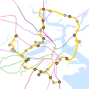
As of June 2008, the revised route of the ring had the following stops:
| Station | Existing Connections | City / Neighborhood | Notes |
|---|---|---|---|
| Logan International Airport | East Boston | West Garage | |
| Airport | East Boston | ||
| Griffin Way | Chelsea | ||
| Chelsea station | Chelsea | ||
| Mystic Mall | |||
| Everett / Massachusetts Route 16 / Gateway Center | Everett | ||
| Wellington | and bus hub | Medford | |
| Assembly | Somerville | ||
| Sullivan Square | and bus hub | Charlestown | Proposed Commuter Rail Stop |
| Inner Belt Road | Somerville | ||
| Lechmere | Cambridge | Station relocation part of Green Line Extension Project; under construction (completion by December 2021) | |
| First Street / Cambridgeside Galleria | Cambridge | ||
| Binney Street | Cambridge | ||
| Fulkerson Street | Cambridge | Served only by one of the BRT routes, the others would go direct to Kendall | |
| Kendall/MIT | Cambridge | ||
| Massachusetts Avenue / Massachusetts Institute of Technology | Cambridge | Via Albany Street | |
| Cambridgeport at George Washington Park | Cambridgeport | Crossing into Grand Junction Railroad right-of-way | |
| Commonwealth Avenue at Boston University Bridge (Boston University West) |
Boston | Via widened Grand Junction Railroad bridge | |
| Yawkey | Boston (Fenway–Kenmore) | ||
| Kenmore | Boston (Fenway–Kenmore) | Minor spur served by only 1 BRT route (#57 bus) | |
| Longwood | Boston | Underground station proposed | |
| Ruggles |
and bus hub |
Boston | |
| Washington Street at Melnea Cass Boulevard | Roxbury | ||
| Dudley Square | and bus hub | Roxbury | |
| Crosstown Center | Dorchester | ||
| BU Medical Center | Boston | ||
| Broadway | South Boston | Unused (since 1919) streetcar tunnel segment above Red Line tracks | |
| A Street | South Boston | ||
| World Trade Center | South Boston | ||
This routing skipped Gilman and Union Squares in Somerville, but these locations would be connected to the new Lechmere Station via the Green Line Extension. The Grand Junction Railroad crossing of the Charles River would be widened to include bus lanes and a multi-use path.

There would be two major spurs. Three different routings were being considered for the first spur, on the west side of the ring, which would leave from Commonwealth Avenue and go to:
- Allston West Station
- North Harvard Street
- Western Avenue
- Harvard, Red Line
The second major spur, on the south side of the ring, would leave from between Crosstown Center and the BU Medical Center, and go to:
- Newmarket Square (new Commuter Rail stop on the Fairmount Line)
- Edward Everett Square, Dorchester
- JFK/UMass, Red Line
These proposal were fairly close to the route covered by the 66 bus.
An interim surface routing was proposed, with multiple stops in the Longwood Medical Area, while the tunnel would be under construction.
The capital cost for this version of the plan was estimated at $2.2 billion, with a projected daily ridership of 170,000. Approximately 53% of the route was either in a bus-only lane, dedicated busway, or tunnel.[12] This was increased from the previous plan for Phase 2, to improve travel times. As a result of the implementation of Phase 2, ridership growth on the Red, Orange, Blue, and Green lines would be slowed, but Commuter Rail ridership boosted. The Urban Ring would have a higher collective ridership than the Orange Line, Blue Line, or the entire Commuter Rail system.[12]
Phase 3
Phase 3[13] would add a rail line on the most heavily traveled portion of the corridor, from Assembly Square in Somerville to Lechmere, Kendall Station, crossing Massachusetts Avenue near MIT, and connecting at Longwood Medical a, Ruggles, and Dudley Square. The exact alignment would be determined through further environmental review, and included possible stops in Union Square Somerville, Cambridgeport and/or Kenmore Square, and a possible new tunnel under the Charles River.
There were three alternatives being considered for Phase 3, which differed from the alternatives described in the Major Investment Study (MIS) and Draft Environmental Impact Review (DEIR). Employment growth projections have also changed since those documents were written. The three proposed options for what type of rail service to build were:
- A light rail branch of the Green Line, mostly on the surface
- A light rail branch of the Green Line, entirely subway
- A heavy rail branch of the Orange Line, entirely subway
Estimated ridership is 282,000–293,000 passengers per day in 2025; about 47,000 would be diverted from cars, and most of the rest would be diverted from trips on congested radial lines, reducing the need to travel through downtown Boston.
Partial implementation
Since the suspension of the overall project, a segment of the original route was constructed, completing in 2018. The "Silver Line Gateway" service (route SL3) has commenced, connecting Downtown and South Boston to the inner-core city of Chelsea, with an intermediate stop serving Logan Airport. The route is a mix of dedicated right-of-way and shared street traffic segments, using articulated buses.
See also
- Interstate 695 (Massachusetts) – a 1960s proposed but cancelled highway involving many of the same communities
References
- eot Urban Ring Notice
- "Urban Ring Phase 2: Fact Sheet", Executive Office of transportation, Commonwealth of Massachusetts, January 2009 (archived 2011)
- Mullan, Jeffery B. (January 22, 2010). "Re: Urban Ring Phase 2, EOEEA #12565" (PDF). Massachusetts Executive Office of Energy and Environmental Affairs.
- "As MBTA Issues Continue, Advocates Push for Transportation Funding Bill". NBC Boston. Retrieved 2020-03-04.
- "Circumferential Transit Report". Boston Transportation Planning Review. Commonwealth of Massachusetts. October 1972. Retrieved 2014-02-11.
- Central Transportation Planning Staff (15 November 1993). "The Transportation Plan for the Boston Region - Volume 2". National Transportation Library. Retrieved 24 January 2013.
- Sources for this section: The official project brochure and Phase 2 Draft EIR.
- MBTA Bus Schedule
- "Urban Ring Documents Library", MBTA. (archived 2006)
- "MBTA Financials", MBTA. Also cf. "Inside the T: Capital Investment Program: The FY06 – FY10 Capital Investment Program", MBTA, (archived 2005)
- Sources for this section: The official project brochure and Phase 2 Draft EIR.
- Sempra Energy
- Source: Official project brochure.
External links
- Massachusetts DoT Website for the Urban Ring Project
- Phase 2 plans
- GRAND JUNCTION FEASIBILITY REVIEW, December 22, 2016, City of Cambridge