Green Line D branch
The D branch of the Massachusetts Bay Transportation Authority's Green Line, also known as the Highland branch or the Riverside Line, is a light rail line in west Boston, Massachusetts, with stations also located in Brookline and Newton. It branches off near Kenmore Square from the Tremont Street and Boylston Street subways from downtown shared with the other light rail lines. It then continues west for about ten miles on a private surface right of way, formerly the Highland branch of the Boston and Albany Railroad. The right of way is double tracked throughout without express tracks. It is grade separated from roads and highways, though there are pedestrian crossings at stations and in Webster Conservation Area in Newton.
| Green Line D branch | |||||||||||||||||||||||||||||||||||||||||||||||||||||||||||||||||||||||||||||||||||||||||||||||||||||||||||||||||||||||||||||||||||||||||||||||||||||||||||||||||||||||||||||||||||||||||||||||||||||||||||||||||||||||||||||||||||||||||||||||||||||||||||||||||||||||||||||||||||||||||||||||||||||||||||||||||||||||||||||||||||||||||||||||||||||||||||||||||||||
|---|---|---|---|---|---|---|---|---|---|---|---|---|---|---|---|---|---|---|---|---|---|---|---|---|---|---|---|---|---|---|---|---|---|---|---|---|---|---|---|---|---|---|---|---|---|---|---|---|---|---|---|---|---|---|---|---|---|---|---|---|---|---|---|---|---|---|---|---|---|---|---|---|---|---|---|---|---|---|---|---|---|---|---|---|---|---|---|---|---|---|---|---|---|---|---|---|---|---|---|---|---|---|---|---|---|---|---|---|---|---|---|---|---|---|---|---|---|---|---|---|---|---|---|---|---|---|---|---|---|---|---|---|---|---|---|---|---|---|---|---|---|---|---|---|---|---|---|---|---|---|---|---|---|---|---|---|---|---|---|---|---|---|---|---|---|---|---|---|---|---|---|---|---|---|---|---|---|---|---|---|---|---|---|---|---|---|---|---|---|---|---|---|---|---|---|---|---|---|---|---|---|---|---|---|---|---|---|---|---|---|---|---|---|---|---|---|---|---|---|---|---|---|---|---|---|---|---|---|---|---|---|---|---|---|---|---|---|---|---|---|---|---|---|---|---|---|---|---|---|---|---|---|---|---|---|---|---|---|---|---|---|---|---|---|---|---|---|---|---|---|---|---|---|---|---|---|---|---|---|---|---|---|---|---|---|---|---|---|---|---|---|---|---|---|---|---|---|---|---|---|---|---|---|---|---|---|---|---|---|---|---|---|---|---|---|---|---|---|---|---|---|---|---|---|---|---|---|---|---|---|---|---|---|---|---|---|---|---|---|---|---|---|---|---|---|---|---|---|---|---|---|---|---|---|---|---|---|
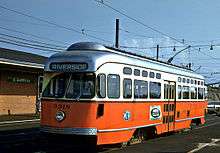
 An inbound train at Newton Center station | |||||||||||||||||||||||||||||||||||||||||||||||||||||||||||||||||||||||||||||||||||||||||||||||||||||||||||||||||||||||||||||||||||||||||||||||||||||||||||||||||||||||||||||||||||||||||||||||||||||||||||||||||||||||||||||||||||||||||||||||||||||||||||||||||||||||||||||||||||||||||||||||||||||||||||||||||||||||||||||||||||||||||||||||||||||||||||||||||||||
| Overview | |||||||||||||||||||||||||||||||||||||||||||||||||||||||||||||||||||||||||||||||||||||||||||||||||||||||||||||||||||||||||||||||||||||||||||||||||||||||||||||||||||||||||||||||||||||||||||||||||||||||||||||||||||||||||||||||||||||||||||||||||||||||||||||||||||||||||||||||||||||||||||||||||||||||||||||||||||||||||||||||||||||||||||||||||||||||||||||||||||||
| Type | Light rail | ||||||||||||||||||||||||||||||||||||||||||||||||||||||||||||||||||||||||||||||||||||||||||||||||||||||||||||||||||||||||||||||||||||||||||||||||||||||||||||||||||||||||||||||||||||||||||||||||||||||||||||||||||||||||||||||||||||||||||||||||||||||||||||||||||||||||||||||||||||||||||||||||||||||||||||||||||||||||||||||||||||||||||||||||||||||||||||||||||||
| System | Green Line | ||||||||||||||||||||||||||||||||||||||||||||||||||||||||||||||||||||||||||||||||||||||||||||||||||||||||||||||||||||||||||||||||||||||||||||||||||||||||||||||||||||||||||||||||||||||||||||||||||||||||||||||||||||||||||||||||||||||||||||||||||||||||||||||||||||||||||||||||||||||||||||||||||||||||||||||||||||||||||||||||||||||||||||||||||||||||||||||||||||
| Locale | Boston, Brookline and Newton, Massachusetts | ||||||||||||||||||||||||||||||||||||||||||||||||||||||||||||||||||||||||||||||||||||||||||||||||||||||||||||||||||||||||||||||||||||||||||||||||||||||||||||||||||||||||||||||||||||||||||||||||||||||||||||||||||||||||||||||||||||||||||||||||||||||||||||||||||||||||||||||||||||||||||||||||||||||||||||||||||||||||||||||||||||||||||||||||||||||||||||||||||||
| Termini | Government Center Riverside | ||||||||||||||||||||||||||||||||||||||||||||||||||||||||||||||||||||||||||||||||||||||||||||||||||||||||||||||||||||||||||||||||||||||||||||||||||||||||||||||||||||||||||||||||||||||||||||||||||||||||||||||||||||||||||||||||||||||||||||||||||||||||||||||||||||||||||||||||||||||||||||||||||||||||||||||||||||||||||||||||||||||||||||||||||||||||||||||||||||
| Stations | 20 | ||||||||||||||||||||||||||||||||||||||||||||||||||||||||||||||||||||||||||||||||||||||||||||||||||||||||||||||||||||||||||||||||||||||||||||||||||||||||||||||||||||||||||||||||||||||||||||||||||||||||||||||||||||||||||||||||||||||||||||||||||||||||||||||||||||||||||||||||||||||||||||||||||||||||||||||||||||||||||||||||||||||||||||||||||||||||||||||||||||
| Daily ridership | 24,632 (surface boardings, 2011)[1] | ||||||||||||||||||||||||||||||||||||||||||||||||||||||||||||||||||||||||||||||||||||||||||||||||||||||||||||||||||||||||||||||||||||||||||||||||||||||||||||||||||||||||||||||||||||||||||||||||||||||||||||||||||||||||||||||||||||||||||||||||||||||||||||||||||||||||||||||||||||||||||||||||||||||||||||||||||||||||||||||||||||||||||||||||||||||||||||||||||||
| Operation | |||||||||||||||||||||||||||||||||||||||||||||||||||||||||||||||||||||||||||||||||||||||||||||||||||||||||||||||||||||||||||||||||||||||||||||||||||||||||||||||||||||||||||||||||||||||||||||||||||||||||||||||||||||||||||||||||||||||||||||||||||||||||||||||||||||||||||||||||||||||||||||||||||||||||||||||||||||||||||||||||||||||||||||||||||||||||||||||||||||
| Opened | July 4, 1959[2] | ||||||||||||||||||||||||||||||||||||||||||||||||||||||||||||||||||||||||||||||||||||||||||||||||||||||||||||||||||||||||||||||||||||||||||||||||||||||||||||||||||||||||||||||||||||||||||||||||||||||||||||||||||||||||||||||||||||||||||||||||||||||||||||||||||||||||||||||||||||||||||||||||||||||||||||||||||||||||||||||||||||||||||||||||||||||||||||||||||||
| Owner | MBTA | ||||||||||||||||||||||||||||||||||||||||||||||||||||||||||||||||||||||||||||||||||||||||||||||||||||||||||||||||||||||||||||||||||||||||||||||||||||||||||||||||||||||||||||||||||||||||||||||||||||||||||||||||||||||||||||||||||||||||||||||||||||||||||||||||||||||||||||||||||||||||||||||||||||||||||||||||||||||||||||||||||||||||||||||||||||||||||||||||||||
| Operator(s) | MBTA | ||||||||||||||||||||||||||||||||||||||||||||||||||||||||||||||||||||||||||||||||||||||||||||||||||||||||||||||||||||||||||||||||||||||||||||||||||||||||||||||||||||||||||||||||||||||||||||||||||||||||||||||||||||||||||||||||||||||||||||||||||||||||||||||||||||||||||||||||||||||||||||||||||||||||||||||||||||||||||||||||||||||||||||||||||||||||||||||||||||
| Character | Underground (Kenmore and eastward) Grade-separated ROW (west of Kenmore) | ||||||||||||||||||||||||||||||||||||||||||||||||||||||||||||||||||||||||||||||||||||||||||||||||||||||||||||||||||||||||||||||||||||||||||||||||||||||||||||||||||||||||||||||||||||||||||||||||||||||||||||||||||||||||||||||||||||||||||||||||||||||||||||||||||||||||||||||||||||||||||||||||||||||||||||||||||||||||||||||||||||||||||||||||||||||||||||||||||||
| Technical | |||||||||||||||||||||||||||||||||||||||||||||||||||||||||||||||||||||||||||||||||||||||||||||||||||||||||||||||||||||||||||||||||||||||||||||||||||||||||||||||||||||||||||||||||||||||||||||||||||||||||||||||||||||||||||||||||||||||||||||||||||||||||||||||||||||||||||||||||||||||||||||||||||||||||||||||||||||||||||||||||||||||||||||||||||||||||||||||||||||
| Track gauge | 4 ft 8 1⁄2 in (1,435 mm) | ||||||||||||||||||||||||||||||||||||||||||||||||||||||||||||||||||||||||||||||||||||||||||||||||||||||||||||||||||||||||||||||||||||||||||||||||||||||||||||||||||||||||||||||||||||||||||||||||||||||||||||||||||||||||||||||||||||||||||||||||||||||||||||||||||||||||||||||||||||||||||||||||||||||||||||||||||||||||||||||||||||||||||||||||||||||||||||||||||||
| |||||||||||||||||||||||||||||||||||||||||||||||||||||||||||||||||||||||||||||||||||||||||||||||||||||||||||||||||||||||||||||||||||||||||||||||||||||||||||||||||||||||||||||||||||||||||||||||||||||||||||||||||||||||||||||||||||||||||||||||||||||||||||||||||||||||||||||||||||||||||||||||||||||||||||||||||||||||||||||||||||||||||||||||||||||||||||||||||||||
As of 2016, the downtown terminus is at Government Center. Free transfer is provided to the rapid transit lines and other light rail lines (the B branch to Boston College, the C branch to Cleveland Circle, and the E branch to Heath Street) at the various subway stops.
The D branch was the most recent light rail line to be built in the Boston area, opening in 1959. It was built on the Boston and Albany Railroad's Highland branch, which closed in 1958 for the conversion. The route has varied scenery, passing golf courses, residential neighborhoods, woods, lakes, and small town centers. The Newton Centre and Newton Highlands stations still feature Richardsonian Romanesque station buildings designed by Shepley, Rutan and Coolidge in the 1890s.
History
Commuter rail
The first section of what became the Highland branch was built by the Boston and Worcester Railroad between Boston and Brookline in 1847. The Charles River branch railroad, a forerunner of the New York and New England Railroad, extended the line to Newton Upper Falls in 1852. The B&A, successor to the Boston and Worcester, bought the line in 1883 and extended to Riverside, rejoining its main line there. The B&A instituted loop service ("Newton Circuit"), going one way to Riverside on the main line and the other way on the Highland branch; the NY&NE continued to use the branch as well.
In 1906 the New York, New Haven and Hartford Railroad built a new cutoff from Needham Junction east to their Dedham branch at West Roxbury, and began routing NY&NE trains that way. However, in 1911, they too began running loop service on the "Needham Circuit", running one way on the old Boston and Providence Railroad to West Roxbury and the other way on the B&A Highland branch.
NYNH&H service through Newton stopped in 1925 and the last B&A train ran over the Highland branch on May 31, 1958.
Conversion to light rail
From mid-1958 to mid-1959, the Highland branch from Riverside to Fenway was converted to light rail by Boston's Metropolitan Transit Authority. This was to be a low budget project and the light rail option was chosen over third rail rapid transit trains because the last 2 miles (3.2 km) to downtown would be via an existing light rail subway. The primary $7M contract was let to the Perini Corporation with an additional $2M for work by the MTA, of which part was designated for added land purchases. With the Riverside terminal just off what is now Interstate 95 and one mile (1.6 km) from today's I-90, the line would be a showpiece of park and ride mass transit from distant suburbs using an existing railroad right of way.
The major project parts included the following:
- Overhead wire 600 volt DC electrification was installed with a new substation at Cook St. Junction, between Eliot and Newton Highlands.
- The existing 105 lb (48 kg) rails were for the most part kept. Replacing worn rail sections, regrading and reballasting was done only where needed.
- A connection was made to the existing subway under Beacon St. leading to Kenmore Square, Boylston St. and the Boston Common.
- Simple ground level paved platforms were installed or upgraded at each of the 12 stops Woodland to Fenway.
- Three aspect color light block signals were added to support a closest train spacing at about a 2-minute headway from Riverside to Reservoir and a 1-minute headway from Reservoir to Fenway.
- The original station buildings (presumably those in poor condition) were demolished except at Newton Highlands and Newton Centre and one other location (near the present Woodland station) that was not an intended stop.
- Small wood frame shelters were added on the inbound side of 11 stops, Woodland to Longwood, with a similar shelter added on the outbound side at a few stops. A roadway overpass provided shelter at Fenway.
- A larger waiting room was built at Riverside and this was also used as a ticketing office by intercity bus lines. The new Riverside terminal complex was southwest of the original B&A Riverside platforms, and fronted Grove St.
- A yard holding about 30 cars, half of the fleet needed for the line, was built at Riverside. Most of the yard was paved so passengers could board cars parked further back in the yard.
- Additional car storage tracks were built just inbound (east) of Reservoir Station next to the existing Reservoir Carhouse. Also, a grade separated outbound to inbound short turn loop was added just west of the station.
- Park and ride lots were built at several stops, the lot at Riverside being the largest, holding nearly 2000 automobiles while the lot at Woodland was second largest, holding about 350 autos.
- Due to budget constraints, no rolling stock was purchased. About sixty Presidents Conference Committee (PCC) cars were taken from the existing 340 odd car fleet for use on the Highland branch. To free up these cars, MTA General Manager Edward Dana discontinued some existing light rail services including the Waverley to Harvard Square, Watertown Square to Harvard Square and North Cambridge to Harvard Square routes. Those three were converted to electric trolley bus (trackless trolley) operation which survives to this day; diesel buses were substituted on some other routes.
Light rail operation began on the Highland branch on July 4, 1959, with single cars or 2 and 3 car trains, running from Riverside or Reservoir to Park St. Station downtown. It was intended to short turn every other rush hour train at Reservoir and berths at Park St. were marked "Riverside/Reservoir." But from the very start, ridership was heavy enough on the outer end of the line to require running nearly all trips to Riverside, the exceptions mainly at the very beginning and very end of the day. Scheduled service frequency ranged from 6 minutes during rush hours to 15 minutes late in the evening. The MTA chose to maintain at least a 10 to 15 minute headway throughout rather than short turn trains at Reservoir during off hours.
The Highland branch was originally given route number 4. (Routes 1, 2, and 3 were today's Red Line, Orange Line, and Blue Line rapid transit, respectively.)
With few exceptions, on board fare collection has been used at the surface stations. Originally the fare was the flat 20 cent rapid transit fare. By 1961 a zone fare system, pay enter inbound and pay exit outbound, was instituted. Fare was 10 cents Riverside to Reservoir, 10 cents Reservoir to Fenway, and 20 cents Fenway to downtown (40 cents for the entire ride). From the mid 1970s to the mid 2000s the outbound ride from Fenway to Riverside was free to speed up alighting from the cars (and a somewhat higher fare charged for the inbound ride). Beginning in 1996, passengers prepaid their fares at the Riverside station, first during morning rush hour only and ca 2006 full-time. Also, after Red Sox games and during a few other heavily traveled times, passengers sometimes prepaid fares at other stations, notably Fenway.
In 1961, passenger boardings were reported at 30,000 per day.[3]
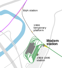
No passenger connection has been provided between the Riverside light rail station and the Riverside station on the B&A main line, now the MBTA Commuter Rail Framingham/Worcester Line. B&A Service to the latter Riverside station ended in the 1970s although a pedestrian underpass and platform still exists, the underpass was closed in 2016 because it is in very poor condition. The nearest commuter rail station on the latter line is in the Newton village of Auburndale, about half a mile away. The tracks from the D branch to the Boston and Albany main were severed and overgrown until, to facilitate the delivery of new light rail vehicles in the 1970s, they were rebuilt and have since been maintained, although they are not used for any regular service. Special commuter rail trains did run to South Station from a temporary platform near the Riverside light rail station from October 23–25, 1996 after heavy rain led to extensive flooding in the Boston area, closure of the Kenmore Square subway station and cutting off of the Riverside line from the downtown subway stations.[4]
The MBTA takes over
By August 1964, when the MBTA took over, service on the Riverside Line was extended on all days but Sundays to Lechmere. Sunday service was extended on September 10, 1966.
In 1967, letter designations replaced the route numbers for the light rail lines and the 4 Riverside–Lechmere became the D Riverside.
Over the years, the following changes in eastern terminal have been made:
- March 25, 1974: cut back from Lechmere to North Station (termini swapped with Green Line B branch). This was in connection with track reconstruction on the surface portion of the line which significantly increased trip time.
- June 26, 1976: cut back to Government Center due to construction at North Station.
- September 11, 1976: extended to North Station (Canal St. loop terminal).
The MBTA's first Boeing light rail vehicles operated on the D branch on December 30, 1976, and turned around at Park Street or Government Center due to the North Station loop catenary not yet upgraded for pantographs.
- January 1, 1977: extended to Lechmere weekdays, cut back to Government Center weekends.
- March 19, 1977: cut back to Government Center on all days.
- June 18, 1977: extended to Lechmere.
- September 9, 1977: cut back to Government Center.
- December 15, 1977: extended to the North Station Canal St. terminal which was reconfigured with three stub end tracks replacing the turning loop. The Riverside line terminated here most of the time over the next few years as it was the only line scheduled with all double ended equipment (Boeing LRVs). Any PCC cars on the line looped at Government Center.
Use of PCC cars on the "D" line officially ended March 23, 1978, but later LRV shortages prompted the occasional return of PCC cars.
- March 21, 1980: extended to Lechmere
- June 21, 1980: cut back to North Station
- April 4, 1981: extended to Lechmere
- January 2, 1983: cut back to Government Center rush hours and middays
- March 26, 1983: extended to Lechmere rush hours, midday and some rush hour "D" trains continue to loop at Government Center
- January 20, 1984, to shortly after: cut back to Government Center rush hours due to North Station on the MBTA Commuter Rail being closed due to a bridge fire, and all rush hour Lechmere service being provided by a shuttle to Government Center
- June 20, 1987: cut back to Government Center always
- March 28, 1997: extended to Lechmere weekends, due to North Station turnback facility being permanently closed
- June 21, 1997: extended to Lechmere always
- June 28, 2004: cut back to Government Center, due to the line north of North Station being closed
- November 12, 2005: Lechmere viaduct reopens, however D line service is not re-extended.
- March 22, 2014: Extended to North Station during midday and evenings on weekdays and all day on weekends. Operates only to Park Street during rush hours and peak times.
- March 22, 2016: reverts to Government Center with reopening of Government Center station.
- Timeline of the extent of "D" service

Track improvements
From the very start of light rail service, in 1959, there were complaints about rough riding followed by continual improvements to the track. While the ride was generally satisfactory at 30 mph (48 km/h), many operators went faster. At least one news report, in response to riders encountering almost violent side-to-side swaying of the cars, mentioned a 35 mph (56 km/h) speed limit imposed by the MBTA management. (A PCC car can reach nearly 50 mph (80 km/h) on level track.) Also, continuously welded rail joints were gradually introduced.
When the first Boeing LRV was brought in for testing in the early 1970s, it became clear that the entire track would need to be rebuilt in order to support the greater weight of those cars and take advantage of their 50 mph (80 km/h) speed. Different techniques were used for maintaining service as each of three sections of the line were rebuilt.
- September 8, 1973, to December 28, 1973. The outer end of the line, from Riverside to Eliot, was taken out of service and passengers transferred to and from substitute buses at Newton Highlands. A temporary turning loop was built just beyond (west of) Newton Highlands in an area known as Cooks Junction. This turning loop is now in use at Seashore Trolley Museum in Maine and is the Loop at Talbot Park.
- Mid-June to mid-September 1974. The inner portion of the line from Reservoir to Fenway was taken out of service for rebuilding. A rather ingeniously placed, at grade, inbound to outbound turning loop was built in the Cleveland Circle-Reservoir yard. This was used by both inbound and outbound cars to access the existing grade separated short turn loop which also connected to Beacon Street and its subway connection, eliminating the need for passengers to make transfers. This section of track has since been reconfigured with crossovers and a relocated ramp out to Beacon St. and the temporary through routing from Reservoir via Beacon St. to the subway can be repeated with cars, now all double ended, changing ends just east of Reservoir. This routing has not always been utilized during disruptions; a bus shuttle from Reservoir to Kenmore or Fenway has been used on several occasions.
- September 13, 1974 until September 29, 1975. Partial bidirectional single track operation between Newton Highlands and Reservoir was done permitting rebuilding of the track, approximately 1 mile (1.6 km) long sections at a time. This maintained a continuous trip by rail from Riverside to downtown Boston although not without an increase of trip time, sometimes by up to ten minutes.[5]
The tracks were rehabilitated again in 2007. This project was undertaken because the newest LRV's, low floor handicapped accessible models from Breda, did not operate reliably over the tracks at the desired 40 to 50 mph (64–80 km/h) speeds. While the Riverside line generally received the newest cars first, it was the last to get the Breda cars due to the need to upgrade the tracks.
- June 23 until August 3, 2007: Shuttle buses replaced rail service between Riverside and Reservoir during the upgrading of that section of track and facilities. Travelers reported increases in trip time of 15 to 30 minutes.[6] The work was originally planned for nighttime hours, but overnight construction noise upset the residents in the neighborhoods through which the line passes. The line was not fully out of service and was used for non-revenue moves to the car shops at Riverside. In addition, full service operated on the July 4 holiday to handle crowds attending the annual concert and fireworks display.[6]
- August 4 until August 31, 2007: Service was replaced by shuttle buses between Reservoir and Fenway for upgrading of track and facilities.[6] A two car train of articulated light rail cars carried roughly the same number of people as a three PCC train. These were the typical rush hour consists during their respective years in service. While the Boeing LRVs and their successors could be operated in three car trains, such operation on a regular basis did not begin until March 21, 2011.[7]
The tracks will be rehabilitated once more. This work between October 8, 2018 throughout 2020, including a full modern signal system for the line from Beaconsfield to Riverside and partial track replacements. Between October & December 2018, shuttle bus service replaced service between Brookline Hills and Reservoir every weekday evening and every weekend until after December 16. During 2019 and 2020, shuttle buses will replace service on 15 weekends and on all weeknights (except holidays) from 8:30 to the end of service. Weekend diversion is particularly between Kenmore and Reservoir with coordination with the Fenway Portal flood prevention project. The shuttles will not stop at Beaconsfield because the nearby streets are too narrow to accommodate the buses.[8]
Incidents and accidents
On May 28, 2008, just after 6pm, two trains collided between Woodland and Waban stations, behind 56 Dorset Road.[9] The driver of the rear train, Terrese Edmonds, was trapped by the collision and died.[9][10] The National Transportation Safety Board investigation concluded that the driver of the rearmost train probably had an episode of micro-sleep caused by sleep apnea.
About a year later, another crash, this one in the central subway, was blamed on an operator texting while driving.[11]
Station listing
| Location | Station | Opened | Notes and connections |
|---|---|---|---|
| Medford | 2021 (planned) | Under construction | |
| Under construction | |||
| Somerville | Under construction | ||
| Under construction | |||
| Under construction | |||
| East Cambridge | Original surface station was open from July 10, 1922 to May 23, 2020; it had not served by the D branch since June 24, 2004. An elevated station (to be served by the D and E branches) is under construction. | ||
| West End | August 20, 1955 | Has not served by the D branch since June 24, 2004. Temporarily closed on May 24, 2020 (was served by the E Branch); it will be served by the D and E branches upon reopening. | |
| North End | June 28, 2004 | Current station for C and E branches; has not served D branch since March 20, 2016 | |
| September 3, 1898 | Current station for C and E branches; has not served D branch since March 20, 2016 | ||
| Downtown Boston | |||
| September 1, 1897 | At Downtown Crossing: | ||
| Boylston | |||
| Back Bay | November 13, 1921 | ||
| October 3, 1914 | |||
| Hynes Convention Center | |||
| Fenway–Kenmore | October 23, 1932 | At Lansdowne: | |
| July 4, 1959 | |||
| Brookline | |||
| Brookline Hills | |||
| Beaconsfield | |||
| Newton | Chestnut Hill | ||
| Eliot | |||
| Waban | |||
Bibliography
- Ronald Dale Karr (1994) The Rail Lines of Southern New England: A Handbook of Railroad History. Branch Line Press. ISBN 0-942147-02-2
References
- "Ridership and Service Statistics" (PDF) (14th ed.). Massachusetts Bay Transportation Authority. 2014.
- Belcher, Jonathan. "Changes to Transit Service in the MBTA district" (PDF). NETransit.
- Edward Dana, Transportation Bulletin #65: Riverside Line Extension, National Railroad Historical Society.
- Archived August 28, 2005, at the Wayback Machine
- Archived September 30, 2007, at the Wayback Machine
- Archived May 22, 2011, at the Wayback Machine
- "MassDOT Blog | The Official Blog of the Massachusetts Department of Transportation". Transportation.blog.state.ma.us. Retrieved 2015-04-30.
- Authority, Massachusetts Bay Transportation. "Green Line D Track and Signal Replacement | Transforming the T | MBTA". www.mbta.com. Retrieved 23 October 2018.
- Bierman, Noah; et al. (28 May 2008). "Trolley operator dies after collision in Newton". Boston Globe. Archived from the original on 25 June 2013. Retrieved 6 August 2013.
External links
| Wikimedia Commons has media related to Green Line D branch. |
- MBTA.com – Green Line – All branches
- History of Newton Highlands – Includes photos of old railway stations
- History of the Railways of Massachusetts
- Railroad History Database