Green Line B branch
The B branch, also called the Commonwealth Avenue branch or Boston College branch, is a branch of the MBTA Green Line light rail system which operates on Commonwealth Avenue west of downtown Boston, Massachusetts. One of four branches of the Green Line, the B branch runs from Boston College station down the median of Commonwealth Avenue to Blandford Street. There, it enters Blandford Street portal into Kenmore station, where it merges with the C and D branches. The combined services run into the Boylston Street subway and Tremont Street subway to downtown Boston. As of 2016, B branch service terminates at Park Street. Unlike the other branches, the B branch runs solely through the city limits of Boston.
| Green Line B branch | ||||||||||||||||||||||||||||||||||||||||||||||||||||||||||||||||||||||||||||||||||||||||||||||||||||||||||||||||||||||||||||||||||||||||||||||||||||||||||||||||||||||||||||||||||||||||||||||||||||||||||||||||||||||||||||||||||||||||||||||||||||||||||||||||||||||||||||||||||||||||||||||||||||||
|---|---|---|---|---|---|---|---|---|---|---|---|---|---|---|---|---|---|---|---|---|---|---|---|---|---|---|---|---|---|---|---|---|---|---|---|---|---|---|---|---|---|---|---|---|---|---|---|---|---|---|---|---|---|---|---|---|---|---|---|---|---|---|---|---|---|---|---|---|---|---|---|---|---|---|---|---|---|---|---|---|---|---|---|---|---|---|---|---|---|---|---|---|---|---|---|---|---|---|---|---|---|---|---|---|---|---|---|---|---|---|---|---|---|---|---|---|---|---|---|---|---|---|---|---|---|---|---|---|---|---|---|---|---|---|---|---|---|---|---|---|---|---|---|---|---|---|---|---|---|---|---|---|---|---|---|---|---|---|---|---|---|---|---|---|---|---|---|---|---|---|---|---|---|---|---|---|---|---|---|---|---|---|---|---|---|---|---|---|---|---|---|---|---|---|---|---|---|---|---|---|---|---|---|---|---|---|---|---|---|---|---|---|---|---|---|---|---|---|---|---|---|---|---|---|---|---|---|---|---|---|---|---|---|---|---|---|---|---|---|---|---|---|---|---|---|---|---|---|---|---|---|---|---|---|---|---|---|---|---|---|---|---|---|---|---|---|---|---|---|---|---|---|---|---|---|---|---|---|---|---|---|---|---|---|---|---|---|---|---|---|---|---|---|---|
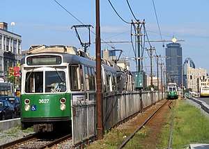 An outbound train approaching Babcock Street station | ||||||||||||||||||||||||||||||||||||||||||||||||||||||||||||||||||||||||||||||||||||||||||||||||||||||||||||||||||||||||||||||||||||||||||||||||||||||||||||||||||||||||||||||||||||||||||||||||||||||||||||||||||||||||||||||||||||||||||||||||||||||||||||||||||||||||||||||||||||||||||||||||||||||
| Overview | ||||||||||||||||||||||||||||||||||||||||||||||||||||||||||||||||||||||||||||||||||||||||||||||||||||||||||||||||||||||||||||||||||||||||||||||||||||||||||||||||||||||||||||||||||||||||||||||||||||||||||||||||||||||||||||||||||||||||||||||||||||||||||||||||||||||||||||||||||||||||||||||||||||||
| Type | Light rail | |||||||||||||||||||||||||||||||||||||||||||||||||||||||||||||||||||||||||||||||||||||||||||||||||||||||||||||||||||||||||||||||||||||||||||||||||||||||||||||||||||||||||||||||||||||||||||||||||||||||||||||||||||||||||||||||||||||||||||||||||||||||||||||||||||||||||||||||||||||||||||||||||||||
| System | Green Line | |||||||||||||||||||||||||||||||||||||||||||||||||||||||||||||||||||||||||||||||||||||||||||||||||||||||||||||||||||||||||||||||||||||||||||||||||||||||||||||||||||||||||||||||||||||||||||||||||||||||||||||||||||||||||||||||||||||||||||||||||||||||||||||||||||||||||||||||||||||||||||||||||||||
| Locale | Boston | |||||||||||||||||||||||||||||||||||||||||||||||||||||||||||||||||||||||||||||||||||||||||||||||||||||||||||||||||||||||||||||||||||||||||||||||||||||||||||||||||||||||||||||||||||||||||||||||||||||||||||||||||||||||||||||||||||||||||||||||||||||||||||||||||||||||||||||||||||||||||||||||||||||
| Termini | Park Street Boston College | |||||||||||||||||||||||||||||||||||||||||||||||||||||||||||||||||||||||||||||||||||||||||||||||||||||||||||||||||||||||||||||||||||||||||||||||||||||||||||||||||||||||||||||||||||||||||||||||||||||||||||||||||||||||||||||||||||||||||||||||||||||||||||||||||||||||||||||||||||||||||||||||||||||
| Stations | 24 | |||||||||||||||||||||||||||||||||||||||||||||||||||||||||||||||||||||||||||||||||||||||||||||||||||||||||||||||||||||||||||||||||||||||||||||||||||||||||||||||||||||||||||||||||||||||||||||||||||||||||||||||||||||||||||||||||||||||||||||||||||||||||||||||||||||||||||||||||||||||||||||||||||||
| Daily ridership | 26,310 (weekday average boardings from surface stops only in 2010–2011)[1] | |||||||||||||||||||||||||||||||||||||||||||||||||||||||||||||||||||||||||||||||||||||||||||||||||||||||||||||||||||||||||||||||||||||||||||||||||||||||||||||||||||||||||||||||||||||||||||||||||||||||||||||||||||||||||||||||||||||||||||||||||||||||||||||||||||||||||||||||||||||||||||||||||||||
| Operation | ||||||||||||||||||||||||||||||||||||||||||||||||||||||||||||||||||||||||||||||||||||||||||||||||||||||||||||||||||||||||||||||||||||||||||||||||||||||||||||||||||||||||||||||||||||||||||||||||||||||||||||||||||||||||||||||||||||||||||||||||||||||||||||||||||||||||||||||||||||||||||||||||||||||
| Opened | 1894 (Kenmore–Cottage Farm Bridge) 1895 (Cottage Farm Bridge–Packards Corner) 1896 (Lake Street–Chestnut Hill Avenue) 1900 (Packards Corner–Chestnut Hill Avenue)[2] | |||||||||||||||||||||||||||||||||||||||||||||||||||||||||||||||||||||||||||||||||||||||||||||||||||||||||||||||||||||||||||||||||||||||||||||||||||||||||||||||||||||||||||||||||||||||||||||||||||||||||||||||||||||||||||||||||||||||||||||||||||||||||||||||||||||||||||||||||||||||||||||||||||||
| Owner | MBTA | |||||||||||||||||||||||||||||||||||||||||||||||||||||||||||||||||||||||||||||||||||||||||||||||||||||||||||||||||||||||||||||||||||||||||||||||||||||||||||||||||||||||||||||||||||||||||||||||||||||||||||||||||||||||||||||||||||||||||||||||||||||||||||||||||||||||||||||||||||||||||||||||||||||
| Operator(s) | MBTA | |||||||||||||||||||||||||||||||||||||||||||||||||||||||||||||||||||||||||||||||||||||||||||||||||||||||||||||||||||||||||||||||||||||||||||||||||||||||||||||||||||||||||||||||||||||||||||||||||||||||||||||||||||||||||||||||||||||||||||||||||||||||||||||||||||||||||||||||||||||||||||||||||||||
| Character | Underground (Kenmore and eastward) Center median running (west of Kenmore) | |||||||||||||||||||||||||||||||||||||||||||||||||||||||||||||||||||||||||||||||||||||||||||||||||||||||||||||||||||||||||||||||||||||||||||||||||||||||||||||||||||||||||||||||||||||||||||||||||||||||||||||||||||||||||||||||||||||||||||||||||||||||||||||||||||||||||||||||||||||||||||||||||||||
| Rolling stock | Kinki Sharyo Type 7 Ansaldobreda Type 8 | |||||||||||||||||||||||||||||||||||||||||||||||||||||||||||||||||||||||||||||||||||||||||||||||||||||||||||||||||||||||||||||||||||||||||||||||||||||||||||||||||||||||||||||||||||||||||||||||||||||||||||||||||||||||||||||||||||||||||||||||||||||||||||||||||||||||||||||||||||||||||||||||||||||
| Technical | ||||||||||||||||||||||||||||||||||||||||||||||||||||||||||||||||||||||||||||||||||||||||||||||||||||||||||||||||||||||||||||||||||||||||||||||||||||||||||||||||||||||||||||||||||||||||||||||||||||||||||||||||||||||||||||||||||||||||||||||||||||||||||||||||||||||||||||||||||||||||||||||||||||||
| Track gauge | 4 ft 8 1⁄2 in (1,435 mm) | |||||||||||||||||||||||||||||||||||||||||||||||||||||||||||||||||||||||||||||||||||||||||||||||||||||||||||||||||||||||||||||||||||||||||||||||||||||||||||||||||||||||||||||||||||||||||||||||||||||||||||||||||||||||||||||||||||||||||||||||||||||||||||||||||||||||||||||||||||||||||||||||||||||
| ||||||||||||||||||||||||||||||||||||||||||||||||||||||||||||||||||||||||||||||||||||||||||||||||||||||||||||||||||||||||||||||||||||||||||||||||||||||||||||||||||||||||||||||||||||||||||||||||||||||||||||||||||||||||||||||||||||||||||||||||||||||||||||||||||||||||||||||||||||||||||||||||||||||
The Green Line Rivalry between Boston College and Boston University is named in reference to the B branch, which runs to both universities.
History
Initial construction

The first sections of what is now the B branch to open were built for what became the Watertown Line and Beacon Street Line. In 1889, the West End Street Railway opened the Beacon Street Line, including a branch that ran from Coolidge Corner to Oak Square along Harvard Avenue, Brighton Avenue, Cambridge Street, and Washington Street.[3]:58 While this route provided service to the fast-growing suburbs of Allston and Brighton, a more direct route was desirable. When Commonwealth Avenue was improved between Governors Square and the junction with Brighton Avenue in the mid-1890s, a 33-foot (10 m)-wide median was included for use by a streetcar line to support real estate development.[4] Service began from Governors Square to Cottage Farm in 1894, to Brighton Avenue in 1895, and along Brighton Avenue to connect with the older trackage on May 18, 1896.[2][3]:48 (That line was extended to near Nonantum Square on June 13, 1896.)[3]:48
Further west, between Chestnut Hill Avenue and the Boston–Newton boundary at Lake Street, a 25-foot (7.6 m)-wide streetcar median was built.[4] Service between Lake Street and downtown Boston began on August 15, 1896.[5] Streetcars ran on Chestnut Hill Avenue, the existing Beacon Street line, Washington Street, and Huntington Avenue.[3]:58 At Lake Street, the line connected with the Commonwealth Avenue Street Railway, which had opened to Auburndale on March 26, 1896.[6]:38
East of Governors Square, the Beacon Street line originally ran on Beacon Street, Massachusetts Avenue, and Boylston Street to Park Square.[3]:54 By the time the Commonwealth Avenue segments opened, streetcars continued along heavily congested tracks on Tremont Street (electrified in 1891) to reach the northern railroad terminals.[3]:61 Both the Nonantum Square and Lake Street lines were rerouted into the Tremont Street subway to terminate at Park Street station soon after the tunnel's September 1, 1897 opening.[3]:21
The Boston Elevated Railway (BERy) leased the West End Street Railway on October 1, 1897, and continued its system expansion.[3]:35 The BERy opened new tracks on Commonwealth Avenue from Chestnut Hill Avenue to Brighton Avenue on May 26, 1900, allowing direct service from Lake Street to downtown via Commonwealth Avenue. Even though much of the land surrounding Commonwealth Avenue in Brighton was not yet developed, the new line was heavily patronized.[3]:58 For most of its length, the 1900-built trackage was not in a center median, but in a reservation between the southbound travel lane and southbound carriage lane. Between Warren Street and Wallingford Road, the reservation was significantly wider than the tracks.[7]
Growing service

The Commonwealth Avenue Street Railway opened the popular Norumbega Park on June 17, 1897.[3] (That line merged into the Newton and Boston Street Railway (N&B) in 1904 and the Middlesex and Boston Street Railway (M&B) in 1909.) Through service between Norumbega Park and Park Street station, operated by BERy east of Lake Street, begun on January 17, 1903.[3]:39 The Newton Street Railway (also merged into the N&B in 1904) began through service between Park Street and Waltham via the Watertown Line on February 23, 1903. When the Cambridge Tunnel opened in April 1912, the Waltham service was rerouted to Central Square station in Cambridge instead.[3]:39 On May 1, 1912, the M&B began a second through service over the Commonwealth Avenue route – this one running to Newton Highlands.[3]:39
The Boylston Street subway opened on October 3, 1914, acting as an extension of the Tremont Street subway to just east of Governors Square, with intermediate stops at Copley Square and Massachusetts Avenue.[3]:40 (A third station, Arlington, was not built until 1921.) The Newton Highlands through service was cut back to Lake Street, where it connected with BERy streetcar service.[3]:39 Norumbega Park through service was similar cut back on November 1, 1914, as the older M&B streetcars could not match the speed of the newer BERy streetcars in the subway.[3]:58
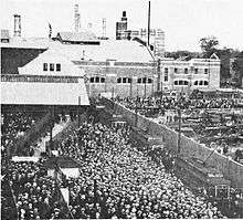
The Commonwealth Avenue line served two major baseball stadiums: Fenway Park (opened 1912) near Governors Square, and Braves Field (opened 1915) in Allston. The BERy opened a prepayment surface station (where riders paid their fares at the stop, rather than on board the streetcar) at Kenmore Street in Governors Square in 1915.[3]:58 The new Braves Field opened on August 18, 1915; it included a loop track between Gaffney Street and Babcock Street with a prepayment station to allow streetcars to directly serve the ballpark.[8] The loop was also used to turn trains for Red Sox games at Fenway Park, and for rush-hour short turns; after November 1945, these short turns also operated during midday and on Saturdays.[9]:108 The loop was heavily used during games; for the 1948 World Series, streetcars ran between Park Street and Braves Field on 45-second headways.[9]:109
Further changes
Around 1916, the BERy built a storage yard for streetcars north of Commonwealth Avenue at Lake Street.[10][11][12] Remaining M&B service to Lake Street was replaced by buses in 1930; the BERy replaced the old transfer station in the median with a new platform and waiting room in the yard on September 12, 1930.[3]:59 An expansion of Reservoir Yard (south of Beacon Street near Chestnut Hill Avenue), completed in May 1940, supplemented Lake Street Yard and eliminated the need to base some Commonwealth Avenue streetcars at Bennett Street Carhouse in Cambridge.[9]:102
In June 1922, the BERy proposed to operate the inner part of the Commonwealth Avenue line as a rapid transit service. Three-car trains of recently acquired center-entrance cars, which had higher capacity and shorter dwell times than older streetcars, would run on headways as low as two minutes at rush hour and four minutes at other times.[13][3]:59 A terminal stations would be built at Linden Street (near Harvard Avenue) in Allston, where passengers would transfer between the subway trains and surface streetcar lines.[13] The Lechmere Square in East Cambridge (already under construction) opened that July, but local opposition to the forced transfer caused the Linden Street terminal plan to be scrapped.[3]:59
The congestion at busy Governors Square caused numerous delays to the streetcar lines. In May 1924, the state legislature directed the Metropolitan District Commission to plan an expanded rapid transit system in Boston, including an extension of the Boylston street Subway under Governors Square.[14] The report, released in December 1926, called for the existing streetcar tunnels in Boston to be reorganized into two rapid transit lines with high-floor rolling stock.[15] One line was to run from East Boston to Brighton, with the East Boston Tunnel (which had been converted from streetcars to rapid transit in 1924) realigned to connect with the Tremont Street subway near Park Street station. The Boylston Street subway would have been extended to Commonwealth Avenue, with a new station under Governors Square. A transfer station between the rapid transit line and the truncated Watertown and Lake Street surface lines was to be located at Warren Street between Commonwealth Avenue and Cambridge Street, near Brighton Center.[15]:5 Intermediate surface stops were to be located at St. Marys Street, Gaffney Street, Packards Corner, Harvard Avenue, and Allston Street.[15]:VI Several busy grade crossings also were to be eliminated, and the report noted that the then-rapid growth along Commonwealth Avenue in Brighton might later justify extension of rapid transit to Lake Street.[15]:32

The subway under Governors Square was projected to cost $5 million (equivalent to $72 million in 2019). The BERy and the city objected to this cost and proposed a $1.4 million plan where flyover ramps would separate Beacon Street auto and streetcar traffic from other traffic in the square.[16] The tunnel was eventually chosen but construction did not begin until 1930, after the legislature lowered the cost that the BERy would pay to rent the subway from the city.[17] Kenmore station and the new subway, which split to separate portals at St. Marys Street on Beacon Street and Blandford Street on Commonwealth Avenue, opened on October 23, 1932.[18][3]:59 The extension was built to support future rapid transit conversion of the Commonwealth Avenue line, including extension of the underground section further west.[17][3]:44
Interest in converting the Commonwealth Avenue line to rapid transit declined as focus shifted to expanding the subway to further suburbs. The 1945 and 1947 Coolidge Commission reports (the next major planning effort after the 1926 report) instead recommended a parallel rapid transit line along the Boston and Albany Railroad corridor, with local streetcar service retained on Commonwealth Avenue.[19][9]:16 However, several smaller improvements were made to the line. A siding was opened at Washington Street on October 27, 1926, allowing trains to be short turned when necessary.[3]:59 On February 7, 1931, the Beacon Street and Commonwealth Avenue lines were extended to Lechmere, replacing shuttle services between Lechmere and various points in the subway.[20][21] On June 30, 1931, the existing crossover west of Blandford Street was replaced by a pocket track, allowing temporary storage of streetcars there. It replaced the former surface cutback at Kenmore for subway short turns, which began on September 24, 1934.[3]:59 Around 1940, the Lake Street line was assigned route number 62 as part of a systemwide renumbering.[9]:27 On May 6, 1940, the line was reassigned from Bennett Street Carhouse (near Harvard Square) to Reservoir Carhouse, eliminating the need for deadhead moves on Cambridge Street.[9]:115
Postwar years
In the early 1940s, the BERy began replacing its older streetcars with the PCC streetcar. PCCs were first used on the Lake Street line in May 1944, and they fully replaced center-entrance cars on the line in regular service on December 10, 1945.[9]:100 The short length of trackage on Chestnut Hill Avenue – which had not been used in revenue service since Lake Street service via Brookline Village was replaced by the route 65 bus in the late 1920s – was modified as part of trackwork related to the introduction of the PCCs. A connecting track from Commonwealth Avenue westbound to Chestnut Hill Avenue southbound was opened on May 31, 1947, completing the wye between the two avenues.[9]:102 On May 21, 1947, in recognition of the expansion of Boston College, the BERy changed the "Lake Street" designation to "Boston College".[9]:99 On August 29, 1947, the privately owned BERy was succeeded by the publicly owned Metropolitan Transit Authority (MTA).[9]:17
The little-used siding at Washington Street was removed in January 1953, leaving only a crossover.[22]:202 In April 1959, all Boston and Albany Railroad Worcester Line stops between Back Bay and Newtonville were closed for the construction of the Turnpike Extension, leaving the Watertown and Boston College lines as the only rail transit serving Allston and Brighton.[23] Boston University purchased Braves Field in 1953 when the Braves moved to Milwaukee, and soon wished to use the loop area for other purposes. After several years of requests, the MTA abandoned the loop on January 15, 1962.[22]:214
In 1960, the wide streetcar reservation between Warren Street and Wallingford Road was narrowed to add additional travel lanes to Commonwealth Avenue, leaving the streetcar tracks in a relocated median between the travel lanes.[24][25]:45 On November 25, 1961, the Boston College was cut back to Park Street station, while the 1959-opened Riverside Line was extended to Lechmere in its stead.[22]:203 In 1963-65, the Commonwealth Avenue bridge over the Boston and Albany Railroad was rebuilt to accommodate the Turnpike Extension. Streetcar service was maintained using a temporary parallel bridge.[26][22]:203
MBTA era
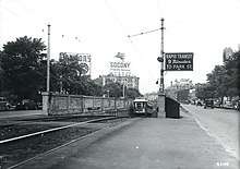
In August 1964, the Massachusetts Bay Transportation Authority (MBTA) replaced the MTA. As part of systemwide rebranding efforts, the remaining streetcar routes feeding the Tremont Street subway became the Green Line on August 26, 1965.[27] In 1967, the five branches were given letters to distinguish them; the Boston College line became the B branch. (The Watertown line became the A branch, while the Beacon Street line became the C branch.)[27] The MBTA experimented with changing the downtown terminals of the Green Line branches (unlike its predecessors, which had changed the downtown terminal of the Boston College line just twice.) The B branch was extended to the new loop at Government Center opened on November 18, 1964 – the first service to regularly use the loop.[27] Over the next two decades, the downtown termini were frequently changed; the B branch variously terminated at Park Street, Government Center, Haymarket, North Station, and Lechmere. On July 30, 1983, the terminus was finally changed to Government Center station, where it would stay until 2004.[27]
On June 21, 1969, the A branch was replaced with Watertown–Kenmore buses, halving streetcar service on Commonwealth Avenue east of Packard's Corner.[27][3]:48 In 1970, the median was moved slightly south between Chestnut Hill Avenue and Lake Street.[28][29] The westbound roadway was lowered several feet below the median between South Street and Greycliff Road, with the Foster Street stop moved 500 feet (150 m) west to the Greycliff Road grade crossing.[25] Around 1975, the stop at University Road was discontinued, while the stop at Alcorn Street was moved 500 feet east to Babcock Street.[25]
Stop consolidation

The B branch is frequently criticized by riders for its slow service, which is largely a result of a high number of stops and level crossings. Until 2004, the line had 22 stops on the surface section, while the C and D branches had 13 each and the E branch just 9.[30]
In late 2003, the MBTA proposed eliminating five surface stops (Greycliff Road, Chiswick Road, Mount Hood Road, Summit Avenue, and Fordham Road) as part of a project to improve the line. The five stops were chosen because they had low ridership and were located very close to other stations.[31] No stops east of Packards Corner were chosen, although they would affect the largest number of riders; despite their close spacing, they have higher ridership, and their proximity to traffic lights lowers the travel time savings from elimination. After a public comment period, Chiswick Road was removed from the proposal, as it serves a nearby elderly housing community.[31] On April 20, 2004, the other four stops were closed as a 6-to-8-month pilot program.[30] On March 15, 2005, after a survey showed that 73% of 1,142 riders surveyed approved of the closures, the MBTA board voted to make the closures permanent.[31]
In 2014, the MBTA began planning to consolidate four stops – Boston University West, St. Paul Street, Pleasant Street, and Babcock Street – located near Boston University's West Campus. The four stops, which are not accessible, will be turned into two fully accessible stops as part of a planned redesign of Commonwealth Avenue between the BU Bridge and Packard's Corner.[32][33] The MBTA awarded a $17.8 million construction contract on March 23, 2020. Construction will last from fall 2020 to fall 2021, with night and weekend bustitution for 32 weeks.[34]
Station listing

| Location | Station | Opened | Notes and connections |
|---|---|---|---|
| East Cambridge | July 10, 1922 | Original surface station was open from July 10, 1922 to May 23, 2020; it had not served the B branch since March 21, 1980. An elevated station (to be served by the D and E branches) is under construction. | |
| West End | August 20, 1955 | Has not served B branch since March 21, 1980. Temporarily closed on May 24, 2020 (was served by the E branch). | |
| North End | June 28, 2004 | Current station for C and E branches; has not served B branch since December 31, 2004 | |
| September 3, 1898 | Current station for C and E branches; has not served B branch since December 31, 2004 | ||
| Downtown Boston | Current station for C, D, and E branches; has not served B branch since March 21, 2014 | ||
| September 1, 1897 | At Downtown Crossing: | ||
| Boylston | |||
| Back Bay | November 13, 1921 | ||
| October 3, 1914 | |||
| Hynes Convention Center | |||
| Fenway–Kenmore | October 23, 1932 | At Lansdowne: | |
| Boston University | Blandford Street | c. 1894 | |
| University Road | Closed c. 1975 | ||
| Boston University West | c. 1895 | ||
| St. Paul Street | |||
| Pleasant Street | |||
| Allston | Babcock Street | c. 1975 | Moved from Alcorn Street around 1975 |
| Packards Corner | c. 1895 | ||
| Fordham Road | May 26, 1900 | Closed on April 20, 2004 | |
| Griggs Street | |||
| Allston Street | |||
| Brighton | Warren Street | ||
| Summit Avenue | Closed on April 20, 2004 | ||
| Mount Hood Road | Closed on April 20, 2004 | ||
| Sutherland Road | |||
| Leamington Road | Closed on June 21, 1980 | ||
| Chiswick Road | |||
| Chestnut Hill Avenue | August 15, 1896 | ||
| South Street | |||
| Greycliff Road | c. 1970 | Moved from Foster Street around 1970; closed on April 20, 2004 | |
| Brighton/Newton | August 15, 1896 |
References
- "Ridership and Service Statistics" (PDF) (14th ed.). Massachusetts Bay Transportation Authority. 2014.
- Engineering and Maintenance Department (1981). History of subways, tunnels and elevated lines. Massachusetts Bay Transportation Authority – via Internet Archive.
- Clarke, Bradley H.; Cummings, O.R. (1997). Tremont Street Subway: A Century of Public Service. Boston Street Railway Association. ISBN 0938315048.
- Annual Report of City Engineer (28 ed.). 1895. pp. 131–137.
- "Newton". Boston Globe. August 15, 1896. p. 3 – via Newspapers.com.

- "Commonwealth Av. Street Railway Company". Boston Globe. March 27, 1896. p. 5 – via Newspapers.com.
- "Atlas of the City of Boston: Ward 25, Brighton". G.W. Bromley and Co. 1909 – via Ward Maps.
- "Handling Traffic at Largest Baseball Park". Electric Railway Journal. Vol. 46 no. 13. September 25, 1915. p. 621 – via Internet Archive.
- Clarke, Bradley H. (2003). Streetcar Lines of the Hub – The 1940s. Boston Street Railway Association. ISBN 0938315056.
- "Sheet 10". Track Lengths of Surface Lines and Subway. Boston Elevated Railway. 1921 – via Ward Maps.
- "Part of Ward 6, City of Newton". Atlas of the City of Newton, Massachusetts. G.W. Bromley and Company. 1917 – via Ward Maps.
- "Part of Brighton, Ward 25, City of Boston". Atlas of the City of Boston, Wards 25 & 26, Brighton. G.W. Bromley and Company. 1916 – via Ward Maps.
- "New Prepayment Station in Boston". Electric Railway Journal. Vol. 59 no. 23. June 10, 1922. p. 951.
- "Chapter 45: Resolve providing for an investigation by the Division of Metropolitan Planning relative to the extension and development of rapid transit service in Boston, Somerville and surrounding cities and towns". Acts and resolves passed by the General Court of Massachusetts in the year 1924. May 24, 1924. pp. 602–603 – via Internet Archive.
- Report on Improved Transportation Facilities in Boston. Division of Metropolitan Planning. December 1926. hdl:2027/mdp.39015049422689.
- "Planning Board Agrees with Boston Elevated". Electric Railway Journal. Vol. 68 no. 20. November 13, 1926. p. 899.
- Annual Report of the Transit Department of the City of Boston. Boston Transit Department. 1930. pp. 1–4 – via Internet Archive.
- Annual report of the public trustees of the Boston Elevated Railway (14 ed.). Boston Elevated Railway. p. 14 – via Internet Archive.
- Boston Elevated Railway; Massachusetts Department of Public Utilities (April 1945), Air View: Present Rapid Transit System – Boston Elevated Railway and Proposed Extensions of Rapid Transit into Suburban Boston – via Wikimedia Commons
- Chasson, George Jr. (1987). Lonto, Arthur J. (ed.). "Boston's Main Line El: The Formative Years 1879-1908". Headlights. Electric Railroader's Association. 49: 25–26.
- "Lake St, Reservoir, to Lechmere trains". Boston Globe. February 5, 1931. p. 7 – via Newspapers.com.
- Clarke, Bradley H. (2015). Streetcar Lines of the Hub: Boston's MTA Through Riverside and Beyond. Boston Street Railway Association. ISBN 9780938315070.
- Humphrey, Thomas J.; Clark, Norton D. (1985). Boston's Commuter Rail: The First 150 Years. Boston Street Railway Association. p. 24. ISBN 9780685412947.
- Keblinsky, Joseph A. (September 1, 1960). "Commonwealth Avenue Gets a Face-Lifting Job". Boston Globe. p. 9 – via Newspapers.com.
- Sindel, David A. (June 2017). Strategies for meeting future capacity needs on the light rail MBTA Green Line. Massachusetts Institute of Technology. hdl:1721.1/111263.
- "Commonwealth Avenue Bridge Replacement". Rollsign. Vol. 54 no. 7/8. Boston Street Railway Association. July–August 2017. p. 11.
- Belcher, Jonathan. "Changes to Transit Service in the MBTA district" (PDF). NETransit.
- "Ask the Globe". Boston Globe. February 18, 1970. p. 2 – via Newspapers.com.
- Rosa, Francis (April 17, 1970). "Korea's Kim looms challenge in Marathon". Boston Globe. p. 29 – via Newspapers.com.
- "Green Line B Branch Service Enhancements" (PDF). TRANSreport. Boston Regional Metropolitan Planning Organization. May 2004. Archived from the original (PDF) on November 26, 2010.
- Daniel, Mac (March 16, 2005). "T drops 4 Green Line stops after results of rider survey". Boston Globe. Archived from the original on March 18, 2005.
- "Comm. Ave. Green Line Improvements Public Meeting" (Press release). Massachusetts Bay Transportation Authority. October 16, 2014.
- O'Rourke, John (October 23, 2014). "T May Eliminate Two Green Line B Stops". BU Today. Retrieved October 31, 2014.
- "FMCB Awards $17.8 Million for B Branch Station Consolidation Work" (Press release). Massachusetts Bay Transportation Authority. March 23, 2020.
External links
| Wikimedia Commons has media related to Green Line B branch. |