Green Line C branch
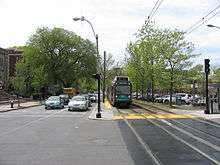
The C branch, also called the Beacon Street Line or Cleveland Circle Line, is one of four branches of the Massachusetts Bay Transportation Authority's Green Line light rail system in the Boston, Massachusetts metropolitan area. The line begins at Cleveland Circle in the Brighton neighborhood of Boston and runs on the surface through Brookline along the median of Beacon Street. Reentering Boston, the line goes underground through the St. Marys Street incline and joins the B and D branches at Kenmore. Trains run through the Boylston Street subway to Copley where the E branch joins, then continue through the Tremont Street subway to downtown Boston. As of 2020, the C branch terminates at North Station.
| Green Line C branch | |||
|---|---|---|---|
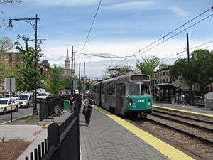 An outbound train at St. Marys Street station | |||
| Overview | |||
| Type | Light rail | ||
| System | MBTA | ||
| Locale | Boston and Brookline, Massachusetts | ||
| Termini | North Station Cleveland Circle | ||
| Stations | 22 | ||
| Daily ridership | 12,466 (2011 surface boardings)[1] | ||
| Operation | |||
| Opened | October 23, 1932 | ||
| Owner | MBTA | ||
| Operator(s) | MBTA | ||
| Character | Underground (Kenmore and eastward) Dedicated Lane ROW (west of Kenmore) | ||
| Rolling stock | Kinki Sharyo Type 7 Ansaldobreda Type 8 | ||
| Technical | |||
| Number of tracks | 2 | ||
| Track gauge | 4 ft 8 1⁄2 in (1,435 mm) | ||
| |||
History
The first tracks on Beacon Street were laid in 1888, running from Massachusetts Avenue west to Coolidge Corner. The next year the rest of the line to Cleveland Circle opened, with access to the Reservoir carhouse. In 1889, the first electric streetcar route (see Green Line A branch) used Beacon Street from Coolidge Corner east to Massachusetts Avenue, then ran south on Massachusetts Avenue and east on Boylston Street to Park Square. That same year, the line on Beacon Street to Cleveland Circle was electrified. Another connection to the Beacon Street line was provided at Washington Square; streetcars came from Brookline Village along Washington Street and turned west on Beacon Street. This line was later extended north on Chestnut Hill Avenue and west on Commonwealth Avenue to Boston College and was the predecessor of the 65 bus route.
The Tremont Street subway opened on September 1, 1897; Beacon Street service was routed into the Public Garden incline at the Public Garden, turning around at Park Street.[2]:57 The Boylston Street subway opened on October 3, 1914 as a westward extension of the Tremont Street subway. The Beacon Street line entered just east of Kenmore Square.[2]:57
On December 14, 1929, most trips of the Kenmore–Lechmere shuttle were extended along Beacon Street to Washington Square. This resulted in 2 1⁄2-minute rush-hour headways on the inner part of the line, with three-car Washington Square–Lechmere trains and two-car Cleveland Circle–Park Street trains on alternating 5-minute headways.[3] On January 9, 1930, the BERy began running Washington Square-bound streetcars express from Kenmore to Kent Street in the afternoon peak due to crowding.[4] The Washington Street service was cut back to Kenmore in June 1930 but resumed that September.[5][6]
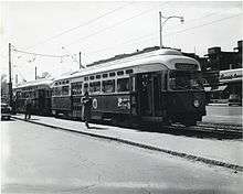
On February 7, 1931, Commonwealth Avenue and Beacon Street service was extended from Park Street to Lechmere using three-car trains; the Washington Street short turns were cut back to Kenmore–Park Street shuttles.[7][8] On October 23, 1932, a westward extension of the subway was opened with an underground Kenmore station. It split into separate tunnels for the Commonwealth Avenue and Beacon Street lines; the latter surfaced at St. Marys Street.[2]:57 The first use of two-car trains of PCC streetcars on the system was on the Beacon Street line on April 16, 1945.[9]:100 At that time, service on the line operated every 2.8 minutes at morning peak, 6 minutes midday, and 2.7 minutes in the afternoon peak.[9]:202 The first use of a three-car train of PCC cars was on July 13, 1946 for a baseball extra; they entered regular service on September 16, 1946.[9]:100 From 1940 until its 1967 naming as the C branch, the Beacon Street line had route number 61.[9]:100
The Riverside Line (later the D branch) was connected to the Beacon Street tunnel near Mountfort Street, with service beginning on July 4, 1959.[2]:63 On November 20, 1961, after 30 years running to Lechmere, the line was cut back to North Station (except Sundays).[10] It was extended back to Lechmere on March 25, 1967; Saturday service was briefly cut to Government Center from June–September 1968.[10] From June 8 to September 11, 1974, D branch trains ran over the C branch due to track work. Trains used a temporary loop at Reservoir and non-revenue tracks on Chestnut Hill Avenue to cross between the two lines.[10] From March 20 to June 25, 1976, C branch night service looped at Kenmore to allow electrical work in the central subway.[10]
Boeing LRVs were first used on the line on January 20, 1978. By March 24, three-car trains of PCC streetcars were no longer used on the C branch; all service was two-car trains of PCCs or LRVs.[10] From June to September 1979, all service on the line was with PCCs due to LRV maintenance issues.[10] The line was cut back to Government Center except at rush hour from March 21 to June 21, 1980, and cut back to Park Street non April 4, 1981.[10] The line was extended to Government Center on June 26, 1982, with LRVs providing all service.[10]
From July 24 to September 10, 1982, the line was replaced by buses to allow for track replacement. Four stops were permanently closed to speed travel times.[10] Service was extended to North Station on July 30, 1983; this was the terminal until a cut to Government Center on March 29, 1997.[10] It was extended again to North Station on January 1, 2005.[10] As of 2020, regular C branch service terminates at North Station.
Traffic signals
The C branch runs on a dedicated median on Beacon Street in Brookline, with a total of 18 grade crossings at major cross streets.[11] Like on its sister B branch, C branch streetcars must stop on traffic signals at street crossings. The signals on Beacon Street in Brookline could in theory be prioritized to make the Green Line run faster. However, the MBTA, which would be expected to pay for the streetcar sensors, does not consider the project to be cost-effective.[12] In 2007, the Boston Globe published letters from riders who are in favor of these sensors,[13] a letter from the MBTA spokesperson arguing that a major study is needed before the MBTA spends money,[14] and a letter arguing that the T's spokesperson is giving too many excuses.[15]
In January 2008, the MBTA hired a consultant to study the issue.[16] As of 2011, the Town of Brookline was considering formally asking the MBTA to cooperate in setting up traffic signal prioritization to speed up Green Line trains on Beacon Street.[17]
In Mayor Marty Walsh's "Go Boston 2030" plan, prioritizing traffic signals on Beacon Street was a proposed idea. The plan indicated that the project is planned to be completed within five years.[18]
Station listing
.JPG)
| Location | Station | Opened | Notes and connections |
|---|---|---|---|
| East Cambridge | July 10, 1922 | Original surface station was open from July 10, 1922 to May 23, 2020; it had not served the B branch since April 3, 1981. An elevated station (to be served by the D and E branches) is under construction. | |
| West End | August 20, 1955 | Has not served B branch since April 3, 1981. Temporarily closed on May 24, 2020 (was served by the E branch). | |
| North End | June 28, 2004 | Original surface station was open from September 3, 1898 to March 27, 1997. Elevated station was open from June 1, 1912 to June 24, 2004. | |
| September 3, 1898 | |||
| Downtown Boston | |||
| September 1, 1897 | At Downtown Crossing: | ||
| Boylston | |||
| Back Bay | November 13, 1921 | ||
| October 3, 1914 | |||
| Hynes Convention Center | |||
| Fenway–Kenmore | October 23, 1932 | At Lansdowne: | |
| Brookline | 1888 | ||
| Carlton Street | Closed on July 24, 1982 | ||
| Hawes Street | |||
| Kent Street | |||
| St. Paul Street | |||
| Winchester Street | 1889 | Closed on July 4, 1982 | |
| Summit Avenue | |||
| Brandon Hall | |||
| Fairbanks | |||
| Winthrop Road | Closed on July 4, 1982 | ||
| Tappan Street | |||
| Dean Road | |||
| Englewood Avenue | |||
| Strathmore Road | Closed on July 24, 1982 | ||
| Brighton | At Reservoir: | ||
References
- "Ridership and Service Statistics" (PDF) (14th ed.). Massachusetts Bay Transportation Authority. 2014.
- Clarke, Bradley H.; Cummings, O.R. (1997). Tremont Street Subway: A Century of Public Service. Boston Street Railway Association. ISBN 0938315048.
- "Added "L" Service on Beacon-St Line". Boston Globe. December 13, 1929. p. 19 – via Newspapers.com.

- "To Prevent Crowding of Reservoir-Beacon Cars". Boston Globe. January 8, 1930. p. 16 – via Newspapers.com.
- "Several Changes in "L" Service Effective Today". Boston Globe. June 7, 1930. p. 9 – via Newspapers.com.
- "Crash of Trolleys Blocks Governor Sq". Boston Globe. July 25, 1930. p. 8 – via Newspapers.com.
- Chasson, George Jr. (1987). Lonto, Arthur J. (ed.). "Boston's Main Line El: The Formative Years 1879-1908". Headlights. Electric Railroader's Association. 49: 25–26.
- "Lake St, Reservoir, to Lechmere trains". Boston Globe. February 5, 1931. p. 7 – via Newspapers.com.
- Clarke, Bradley H. (2003). Streetcar Lines of the Hub – The 1940s. Boston Street Railway Association. ISBN 0938315056.
- Belcher, Jonathan. "Changes to Transit Service in the MBTA district" (PDF). NETransit.
- "Google Maps". Google Inc. 2011. Retrieved 27 September 2011.
- Masis, Julie (2 December 2007). "Beacon gets smart lights, but T isn't along for the ride". The Boston Globe. Retrieved 31 July 2011.
- "Letters". The Boston Globe. 9 December 2007. Retrieved 31 July 2011.
- "Letters". The Boston Globe. 16 December 2007. Retrieved 31 July 2011.
- "Letters". The Boston Globe. 30 December 2007. Retrieved 31 July 2011.
- Masis, Julie (27 January 2008). "T may get edge on Beacon St". The Boston Globe. Retrieved 31 July 2011.
- Parker, Brock (January 11, 2011). "Brookline mulling how to speed up C Line along Beacon Street". boston.com (The Boston Globe). Retrieved 2011-08-02.
- "Go Boston 2030 Full Plan" (PDF). 7 March 2017. p. 168. Retrieved 7 August 2017.