Garland, Texas
Garland is a city in the U.S. state of Texas. It is located northeast of Dallas and is a part of the Dallas–Fort Worth metroplex. It is located almost entirely within Dallas County, except a small portion located in Collin and Rockwall counties. At the 2010 census the city had a population of 226,876. In 2019, the population rose to 239,928, making it the 93rd-most populous city in the United States of America and the 12th-most populous city in Texas. Garland is second only to the city of Dallas in Dallas County by population and has easy access to downtown Dallas via public transportation including two Dart Blue line stations and buses.
Garland, Texas | |
|---|---|
 State & 5th Street in Downtown | |
 | |
| Motto(s): Texas Made Here[1] | |
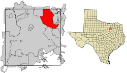 Location within Dallas County | |
 Garland Location within Texas  Garland Location within the United States | |
| Coordinates: 32°54′26″N 96°38′7″W | |
| Country | United States |
| State | Texas |
| County | Dallas |
| Incorporated | 1891[2] |
| Government | |
| • Type | Council-Manager |
| • City Council | Mayor Scott LeMay David Gibbons Deborah Morris Jerry Nickerson James Bookhout Rich Aubin Robert Vera Dylan Hedrick Robert John Smith |
| • City Manager | Bryan Bradford |
| • City Attorney | Brad Neighbor |
| Area | |
| • Total | 57.1 sq mi (147.9 km2) |
| • Land | 57.1 sq mi (147.9 km2) |
| • Water | 0 sq mi (0.0 km2) |
| Elevation | 551 ft (168 m) |
| Population (2019) | |
| • Total | 239,928 |
| • Density | 4,200/sq mi (1,600/km2) |
| Time zone | UTC-6 (CST) |
| • Summer (DST) | UTC-5 (CDT) |
| ZIP codes | 75040-75049 |
| Area code(s) | 214, 972, 469 |
| FIPS code | 48-29000[3] |
| GNIS feature ID | 1388185[4] |
| Website | garlandtx.gov |
History
Immigrants began arriving in the Peters colony area around 1850, but a community was not created until 1874. Two communities sprang up in the area: Embree, named for the physician K. H. Embree, and Duck Creek, named for the local creek of the same name. A rivalry between the two towns ensued as the area began to grow around the Santa Fe Railroad depot. Eventually, to settle a dispute regarding which town should have the local post office, Dallas County Judge Thomas A. Nash asked visiting Congressman Joe Abbott to move the post office between the two towns. The move was completed in 1887. The new location was named Garland after U.S. Attorney General Augustus Hill Garland. Soon after, the towns of Embree and Duck Creek were combined, and the three areas combined to form the city of Garland, which was incorporated in 1891. By 1904, the town had a population of 819 people.[2]
In 1920, local businessmen financed a new electrical generator plant (sold by Fairbanks-Morse) for the town. This later led to the formation of Garland Power and Light, the municipal electric provider that still powers the city today.[2][5]
On May 9, 1927, a devastating F4 tornado struck the town and killed 15 people,[6] including the former mayor, S. E. Nicholson.
Businesses began to move back into the area in the late 1930s. The Craddock food company and later the Byer-Rolnick hat factory (now owned by Resistol) moved into the area. In 1937, KRLD, a major Dallas radio station, built its radio antenna tower in Garland, and it is operational to this day. During World War II, several aircraft plants were operated in the area, and the Kraft Foods company purchased a vacant one after the war for its own use. By 1950, the population of Garland exceeded 10,000 people.[2] From 1950 to 1954, though, the Dallas/Garland area suffered from a serious and extended drought, so to supplement the water provided by wells, Garland began using the water from the nearby Lake Lavon. The suburban population boom that the whole country experienced after World War II also reached Garland by 1960, when the population nearly quadrupled from the 1950 figure to about 38,500. By 1970, the population had doubled to about 81,500. By 1980, the population reached 138,850.[2] Charles R. Matthews served as mayor in the 1980s; he was later a member of the elected Texas Railroad Commission.
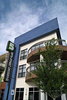
In the 2000s, Garland added several notable developments, mostly in the northern portion of the city. Hawaiian Falls waterpark opened in 2003. (Garland formerly had a Wet 'n Wild waterpark, which closed in 1993). The Garland Independent School District's Curtis Culwell Center (formerly called the Special Events Center),[7] an arena and conference facility, opened in 2005. Later that year, Firewheel Town Center, a Main Street-style outdoor mall, owned by Simon Property Group, opened in October 2005. It has over 100 business and includes an AMC theater. In 2009, the city, in conjunction with the developer Trammell Crow Company, finished a public/private partnership to develop the old parking lot (the land between 5th Street, 6th Street, and on the north side of Austin Street) into a new mixed-use, transit-oriented development named 5th Street Crossing. Catercorner to both City Hall and the downtown DART Rail station, the project consists of 189 residential apartment units, 11,000 square feet (1,000 m2) of flex retail, and six live-work units.[8]
The southeast side of Garland suffered a major blow on the night of December 26, 2015 after a large EF4 tornado struck the area, moving north from Sunnyvale. At least eight fatalities were confirmed in the city from this event.[9]
Garland Oct. 20, 2019 EF-1 tornado struck the area.[10]
Geography
| Garland, Texas | ||||||||||||||||||||||||||||||||||||||||||||||||||||||||||||
|---|---|---|---|---|---|---|---|---|---|---|---|---|---|---|---|---|---|---|---|---|---|---|---|---|---|---|---|---|---|---|---|---|---|---|---|---|---|---|---|---|---|---|---|---|---|---|---|---|---|---|---|---|---|---|---|---|---|---|---|---|
| Climate chart (explanation) | ||||||||||||||||||||||||||||||||||||||||||||||||||||||||||||
| ||||||||||||||||||||||||||||||||||||||||||||||||||||||||||||
| ||||||||||||||||||||||||||||||||||||||||||||||||||||||||||||
Garland is located at 32°54′26″N 96°38′7″W (32.907325, -96.635197).[11] According to the United States Census Bureau, the city has a total area of 57.1 square miles (147.9 km²), all land.
Neighborhoods and historical communities
- Buckingham North
- Duck Creek
- Centerville
- Eastern Hills
- Embree
- Firewheel
- Oaks
- Rose Hill
- Spring Park
- Travis College Hill Addition[12]
- Valley Creek*
- The 5
- Oakridge
- Brentwood Place
- Brentwood Village
Climate
Garland is part of the humid subtropical region. The average warmest month is July, with the highest recorded temperature being 111 °F (44 °C) in 2000. On average, the coolest month is January, with the lowest recorded temperature was −3 °F (−19 °C) in 1989. The maximum average precipitation occurs in May.
Demographics
| Historical population | |||
|---|---|---|---|
| Census | Pop. | %± | |
| 1890 | 478 | — | |
| 1900 | 819 | 71.3% | |
| 1910 | 804 | −1.8% | |
| 1920 | 1,421 | 76.7% | |
| 1930 | 1,584 | 11.5% | |
| 1940 | 2,233 | 41.0% | |
| 1950 | 10,571 | 373.4% | |
| 1960 | 38,501 | 264.2% | |
| 1970 | 81,437 | 111.5% | |
| 1980 | 138,857 | 70.5% | |
| 1990 | 180,650 | 30.1% | |
| 2000 | 215,768 | 19.4% | |
| 2010 | 226,876 | 5.1% | |
| Est. 2019 | 239,928 | [13] | 5.8% |
| U.S. Decennial Census Texas Almanac: 1850–2000 | |||
As of the 2010 census, 226,876 people, 75,696 households, and 56,272 families resided in the city. The population density was 3,973.3 people per square mile (1,534.1/km²). The 80,834 housing units averaged 1,415.7 per square mile (546.5/km²). The racial makeup of the city was 57.5% White, 14.5% African American, 0.8% Native American, 9.4% Asian, 0.04% Pacific Islander, 14.4% some other race, and 3.3% from two or more races. Hispanics or Latinos of any race were 37.8% of the population.[14] Non-Hispanic Whites were 36.7% of the population,[15] down from 86.5% in 1980.[16]
Of the 75,696 households in 2010, 36.9% had children under the age of 18 living with them, 52.0% were headed by married couples living together, 16.1% had a female householder with no husband present, and 25.7% were not families. About 20.8% of all households were made up of individuals, and 6.5% had someone living alone who was 65 years of age or older. The average household size was 2.99, and the average family size was 3.48.[14]
In the city, the population was distributed as 28.5% under the age of 18, 9.6% from 18 to 24, 28.0% from 25 to 44, 24.7% from 45 to 64, and 9.2% who were 65 years of age or older. The median age was 33.7 years. For every 100 females, there were 96.1 males. For every 100 females age 18 and over, there were 92.6 males.[14]
According to the Census Bureau's 2007–2011 American Community Survey, the median income for a household in the city was $52,441, and for a family was $57,293. Males had a median income of $36,041 versus $33,950 for females. The per capita income for the city was $20,000. About 11.1% of families and 14.5% of the population were below the poverty line, including 21.7% of those under age 18 and 7.3% of those age 65 or over.[17]
Vietnamese Americans
As of 2000, 12% of the foreign-born population of Garland originated from Vietnam. Two strip-style shopping malls along Walnut Street cater to Vietnamese people, and a community center as of 2009 hosts first-generation Vietnamese immigrants.[18] According to the 2010 Census, Garland has the 16th largest number of Vietnamese Americans in the United States.
Economy
In the late 1930s, the Craddock food company, which manufactured pickles, moved to town. In 1937, the KRLD (Dallas) radio tower was constructed in Garland. During World War II, several aircraft plants operated in the Garland area. After the war, Kraft Foods bought the Continental Motors Plant to retool for its manufacture. The Kraft Foods plant still operates to this day. As a station on two railroads, Garland was a major onion-shipping point in the 1940s.[2]
Resistol Hats in Garland is a notable manufacturer of premium hats, many of which have been worn by or given to notable figures around the world. The company has long been an important part of Garland's manufacturing base.[19]
The company was founded by E.R. Byer and Harry Rolnick, who established Byer-Rolnick in Dallas in 1927. At the time, the company produced men's felt hats. The company used the name "Resistol Hats" to indicate that the hats could "resist-all" weather conditions. Some accounts contend the name was given because the headbands in the company's hats were more resistant to scalp oil.[20]
The growing firm needed to expand. In 1938, it moved to a larger facility in Garland, where Resistol hats continue to be manufactured today. For decades, residents surrounding the hat factory could set their clocks to its whistle.[20]
In the early 1980s, Garland had one of the lowest poverty rates of cities in the country. In 1990, it had a population of 180,650 and 2,227 businesses, making it Dallas County's second-largest city and the tenth-largest in the state. Today, Garland had a variety of industries, including electronics, steel fabrication, oilfield equipment, aluminum die casting, hat manufacture, dairy products, and food processors.[2]
Top employers
According to the City of Garland's Economic Development Partnership website,[21] the top employers in the city are:
| # | Employer | # of Employees |
|---|---|---|
| 1 | Garland ISD | 7,425 |
| 2 | City of Garland | 2,000 |
| 3 | Kraft Foods | 796 |
| 4 | US Food Service | 520 |
| 5 | Epiroc Drilling Solutions | 460 |
| 6 | SilverLine Window | 425 |
| 7 | Hatco (Resistol) | 390 |
| 8 | L3-Communication | 350 |
| 9 | Arrow Fabricated Tubing | 340 |
| 10 | Valspar | 300 |
Garland has lost many of their major employers over the last few years. Raytheon moved to Richardson, Baylor Scott and White closed, L3 Technologies closed, and many others.
Arts and culture
.jpg)
Entertainment
- The Granville Arts Center is a complex owned and operated by the city. Included within the complex are two elegant proscenium theatres which seat 720 and 200, respectively. Also included as part of the complex is the Plaza Theatre, which has seating for 350. The Atrium at the Granville Arts Center is a 6,500-square-foot (600 m2) ballroom encased in glass on two sides and opening onto an elegant outdoor courtyard. The Atrium provides civic, community and commercial organizations the opportunity to house banquets, receptions, trade shows, and conventions.[22]
- The Plaza Theater[23]
- Pace House[24]
- Nickelrama Arcade[25]
Historic places
- The Garland Landmark Museum is housed in the former 1901 Santa Fe depot. Inside are historical artifacts and documents representing the period from 1850 to the present.[26]
- Historic Downtown Garland[27]
- Travis College Hill Historic District, a residential neighborhood in downtown Garland, was the first site ever in Garland history added to the National Register of Historic Places, administered by the U.S. Department of the Interior through its National Park Service. Two months later, the downtown Square and surrounding buildings became the second site in Garland added to the prestigious listing. Travis College Hill consists of 12 homes whose period of significance is 1913 to 1960. Travis College Hill was platted in January 1913 by. developer R.O. Travis.
Libraries
.jpg)
On May 9, 1927, a tornado destroyed much of the city and killed 17 people, including a former mayor, S. E. Nicholson. Six years later, the Nicholson Memorial Library opened in his honor.[2]
The Nicholson Memorial Library System is also the Major Resource Center, or headquarters, of the Northeast Texas Library System (NETLS). NETLS serves a 33-county area that includes 105 member libraries. The NETLS headquarters and offices have been housed in NMLS' Central Library since 1983.[28]
Parks and recreation
Garland includes over 2,880 acres (1,170 ha) of park land, six recreation centers, and 63 parks.[29][30]
Government
- M. Davis Williams, 1891-1893[31][32]
- Frank.M. Haygood, 1893-1895
- J. Jasper Hawkins, 1895-1897
- John A. Martin, 1897-1900
- Thomas J. Swim, 1900–1901, 1903–1904, 1908–1910
- Charles H. Marshall, 1901
- John H. Cullom, 1901-1903
- E.G. Cole, 1906-1908
- George A. Alexander, 1910–1912, 1914–1915, 1918–1920
- John F. White, 1912-1914
- R.L. Reagan, 1913
- George W. Crossman, 1916-1917
- R.D. Murphree, 1920-1924
- S.E. Nicholson, 1924-1925
- G.L. Davis, 1925-1927
- C.S. Nelson, 1927-1929
- W.C. Jamison, 1929–1931, 1934-1936
- M.D. Williams, 1931-1934
- J.A. Alexander, 1936-1939
- Ray Olinger, 1939-1948
- D. Cecil Williams, 1948-1952
- H.A. Walker, 1952-1956
- W.H. Bradfield, Sr., 1956-1958
- Ernest E. Wright Jr., 1958-1962
- Carl Cooper, 1962-1966
- Jim Toler, 1966-1970[33]
- Rufus Rupard, 1970-1972
- Don Raines, 1972-1976
- Charles G. Clack, 1976-1982
- Ruth Nicholson, 1982-1984 and 1988-1990
- Charles R. Matthews, 1984-1986
- Bill Tomlinson, 1986-1988 and 1990-1992
- Bob Smith, 1992-1994
- James B. Ratliff, 1994-1998
- Jim Spence, 1998-2002
- Bob Day, 2002-2007
- Ronald Jones, 2007-2012[34]
- Douglas Athas, 2013–2018[35]
- Lori Barnett-Dodson, 2018-2019
- Scott LeMay, 2019–present
The city of Garland is a voluntary member of the North Central Texas Council of Governments association, the purpose of which is to coordinate individual and collective local governments and facilitate regional solutions, eliminate unnecessary duplication, and enable joint decisions.
The Parkland Health & Hospital System (Dallas County Hospital District) operates the Garland Health Center.[36]
The Texas Department of Public Safety (DPS) operates the Region I office in Garland.[37]
The Texas Department of Criminal Justice (TDCJ) operates the Dallas II District Parole Offices in Garland.[38]
The United States Postal Service operates the Garland,[39] Kingsley,[40] and North Garland post offices.[41]
Education
Primary and secondary schools

Most of Garland is in the Garland Independent School District (GISD). Parts of Garland extend into other districts, including the Dallas, Mesquite, and Richardson Independent School Districts.
The GISD does not have school zoning, so GISD residents may apply to any GISD school.
The GISD portion of Garland is served by several high schools. Garland High School is home to the district's international baccalaureate program. North Garland High School is the math, science and technology magnet. Lakeview Centennial High School is GISD's "College and Career" magnet school. South Garland High School is known within the community for its vocational cosmetology program. Other GISD high schools include Naaman Forest, Rowlett, and Sachse High Schools.
The Mesquite ISD portion of Garland is served by Price Elementary School, Vanston Middle School, and North Mesquite High School.
The Richardson ISD portion is served by O. Henry Elementary School, Liberty Junior High School, and Berkner High School, which are in the western portion of Garland.
As of November 2006, the GISD had 52,391 students and 3,236 teachers, for an average ratio of 16.2 students per teacher.[42] The 2006 GISD property tax rate was $1.5449 per hundred dollars of assessed property value.[43]
For a private Christian school option, hundreds of families have chosen for their children to attend Garland Christian Academy, which was founded in 1972. The city also has a PreK-12 Islamic school, Brighter Horizons Academy.
Colleges and universities
.jpg)
An article by Richland College states that, "Richland College officially opened its Garland Campus on June 30, 2009. The campus, located on the corner of Walnut and Glenbrook, serves as a location for area companies, organizations, and individuals. Currently, the campus offers courses and training for Management Skills, Business Productivity Skills, Language Training, Manufacturing/Construction Skills, and Computer/IT Training. This remote campus also provides a separate lease space currently used by the Garland Chamber of Commerce."[44]
Garland is also the home of Amberton University, a fully accredited private university with both undergraduate and graduate degree programs. Amberton University was formerly known as Amber University and previously known as Abilene Christian University at Dallas.
Infrastructure
Transportation
The city of Garland has a lower than average percentage of households without a car. In 2015, 4.6 percent of Garland households lacked a car, and that figure was virtually unchanged in 2016 (4.4 percent). The national average was 8.7 percent in 2016. Garland averaged 2.04 cars per household in 2016, compared to a national average of 1.8.[45] According to the American Community Survey for 2016 (5-year average), 78.8 percent of Garland residents commuted by driving alone, 13.1 carpooled, 2.5 used public transportation, and .9 percent walked. About 1.3 percent of Garland residents commuted to work by bicycle, taxi, motorcycle, or some other means, while 3.5 percent worked out of the home.[46]
Major highways
.svg.png)
.svg.png)


- Belt Line Loop (some parts are named as First Street and Broadway Blvd) serves as an outer loop around the Dallas suburbs.
Trains
A Kansas City Southern track runs parallel to State Highway 78 (Garland Road and Lavon Drive), coming out of Dallas and heading all the way through the other side of Garland towards Wylie. There is also a Dallas, Garland and Northeastern Railroad line serving industries around the city.
Air
The city of Garland owns the Garland/DFW Heloplex.[47] The facility was the first municipal heliport in Texas when it opened in November 1989.[48] Located at 2559 S. Jupiter Road, the heliport is operated by SKY Helicopters Inc.,[49] which was initially awarded a lease of the facility in January 1993.[50]
Utilities
The city of Garland operates the city's water system and waste services. Electricity for about 85% of Garland is provided by the city's municipal utility, Garland Power and Light (GP&L). Electricity for the other 15% was formerly provided by TXU, but is now supplied by multiple companies after deregulation of the Texas electricity market.
Water and wastewater utilities
Garland is an original member city of the North Texas Municipal Water District (NTMWD). The vision of the city fathers in the early 1940s resulted in Garland and its companion member cities benefitting from reliable, high quality, affordable water from the water district's many reservoirs.
The effluent from Garland's wastewater treatment plant flows through a NTMWD man-made, 1,840-acre (7.4 km2) wetland. This provides a natural habitat for a wide variety of birds and reduces the sediment, nitrogen, and phosphorus contents of the water to a drinkable level. Through the use of selected aquatic plants, this environmentally friendly project will provide millions of gallons of reusable water and reduce the environmental impact.
Garland Power and Light

Garland Power and Light (GP&L) was founded in 1923 to provide Garland residents not-for-profit public utility services, locally controlled by its citizens. GP&L provides services to over 69,000 customers, making it the fourth largest municipal utility in Texas and the 41st largest in the nation.
Garland Power and Light has three gas-fired generating plants, which combined have 640 megawatts of generation capacity. In addition, Garland partners with the Texas Municipal Power Agency which operates the 462-megawatt coal-fired Gibbons Creek Power Plant. Garland's electric distribution system has 1,007 mi (1,621 km) of overhead lines and 1,000 mi (1,600 km) of underground lines. Its transmission system consists of 23 substations and 133 mi (214 km) of transmission lines. Garland's peak load for 2007 was 483 megawatts, with annual operating revenues of nearly $238 million.[51]
The two national indices are System Average Interruption Frequency Index SAIFI and System Average Interruption Duration Index SAIDI. SAIFI is the number of times power is lost, and SAIDI is the length of time the power is out. These standards compare the frequency and duration of power outages and the customers affected. Garland is one of the few power providers that post their SAIDA/SAIFI numbers.
Notable people
- Ember Moon, WWE.[52]
- Crystal Bernard, starred as K.C. Cunningham on the TV sitcom Happy Days and as Helen in the show Wings.
- Mookie Blaylock, NBA basketball player
- C.L. Bryant, an African-American Baptist minister and conservative talk show host over KEEL in his native Shreveport, Louisiana, headed the NAACP when he formerly resided in Garland.
- Amber Dotson, American country music artist.
- Samuel Eguavoen, American football player
- Caleb Landry Jones, American actor
- Mitchel Musso, actor and musician
- Adrian Phillips, NFL football player
- LeAnn Rimes, musician, grew up here.
- Gene Summers, musician[53]
- Tyrese Maxey, University of Kentucky Basketball Player
- Brian Adam Douglas, Brooklyn based artist
References
- "City of Garland Texas". City of Garland Texas. Archived from the original on October 31, 2012. Retrieved October 19, 2012.
- "Garland, TX". Texas State Historical Association. Retrieved January 8, 2012.
- "U.S. Census website". United States Census Bureau. Retrieved January 31, 2008.
- "US Board on Geographic Names". United States Geological Survey. October 25, 2007. Retrieved January 31, 2008.
- "A Brief History of Garland". City of Garland-. Retrieved January 8, 2012.
- Grazulis, Thomas P. (1993). Significant Tornadoes 1680-1991: A Chronology and Analysis of Events. St. Johnsbury, Vermont: Environmental Films. pp. 808–811. ISBN 1-879362-03-1.
- "Curtis Culwell Center". specialeventscenter.com. Retrieved May 4, 2015.
- "JHP - Architecture & Urban Design" (PDF). Jhparch.com. Retrieved August 27, 2017.
- "Texas under siege: Tornadoes, flooding, snow and ice". USAToday. Retrieved December 27, 2015.
- "Tornado Damage: Dallas, Garland, Midlothian, Rowlett From Oct. 20, 2019". nbcdfw. Retrieved October 21, 2019.
- "US Gazetteer files: 2010, 2000, and 1990". United States Census Bureau. February 12, 2011. Retrieved April 23, 2011.
- "Garland Texas - News Details". Garlandtx.gov. Archived from the original on November 13, 2016. Retrieved November 13, 2016.
- "Population and Housing Unit Estimates". Retrieved May 21, 2020.
- "Profile of General Population and Housing Characteristics: 2010 Demographic Profile Data (DP-1): Garland city, Texas". United States Census Bureau. Retrieved January 12, 2012.
- "Garland (city), Texas". State & County QuickFacts. U.S. Census Bureau.
- "Race and Hispanic Origin for Selected Cities and Other Places: Earliest Census to 1990". U.S. Census Bureau. Archived from the original on August 6, 2012.
- "DP03: Selected Economic Characteristics, 2007-2011 American Community Survey 5-Year Estimates". United States Census Bureau. Retrieved June 24, 2013.
- Brettell, Caroline B. '"Big D" Incorporating New Immigrants in a Sunbelt Suburban Metropolis' (Chapter 3). In: Singer, Audrey, Susan Wiley Hardwick, and Caroline Brettell. Twenty-First Century Gateways: Immigrant Incorporation in Suburban America (James A. Johnson metro series). Brookings Institution Press, 2009. ISBN 0815779283, 9780815779285. Start p. 53. CITED: p.62.
- "Texas Primer: The Resistol Hat". Texas Monthly. Retrieved December 25, 2011.
- "Resistol Hat History". Resistol Hats. Retrieved December 25, 2011.
- "Major Employers & Clusters - Garland Texas Economic Development Partnership - Garland Economic Development Partnership". Garlandedp.com. Retrieved December 4, 2017.
- "Archived copy". Archived from the original on September 7, 2009. Retrieved September 3, 2009.CS1 maint: archived copy as title (link)
- "Archived copy". Archived from the original on September 8, 2009. Retrieved September 3, 2009.CS1 maint: archived copy as title (link)
- "Archived copy". Archived from the original on September 5, 2009. Retrieved September 3, 2009.CS1 maint: archived copy as title (link)
- i3dthemes.com. "Nickelrama Arcade, Our games use real nickels". Nickelrama.com. Retrieved August 27, 2017.
- "Garland Landmark Society - Home". Garlandhistorical.org. Retrieved August 27, 2017.
- "HugeDomains.com - GarlandDowntown.com is for sale (Garland Downtown)". Garlanddowntown.com. Retrieved August 27, 2017.
- "History of Nicholson Memorial Library System". Nicholson Memorial Library System-. Retrieved January 8, 2012.
- "Parks". Garland Parks-. Retrieved January 8, 2012.
- "Recreation Centers". Garland Parks-. Retrieved January 8, 2012.
- "Composition of the Garland City Council from the City's Incorporation in 1891 to Present". Garland Landmark Society. Retrieved April 8, 2017.
- Richard Abshire (2009). Garland: a Contemporary History. San Antonio: Historical Publishing Network. ISBN 978-1-893619-92-0. (Includes list of mayors)
- "Fast Money and Fraud", New York Times, April 23, 1989
- "Mayor". City of Garland. Archived from the original on August 29, 2012.
- "Mayor". City of Garland. Retrieved April 7, 2017.
- "Clinic Sites and Services: Archived May 16, 2008, at the Wayback Machine" Parkland Health & Hospital System. Retrieved on October 25, 2012.
- "Regional Contact Information" (Archive). Texas Department of Public Safety. Retrieved on April 24, 2014.
- "Parole Division Region II Archived August 20, 2011, at the Wayback Machine." Texas Department of Criminal Justice. Retrieved on May 15, 2010.
- "Post Office Location - GARLAND Archived June 11, 2010, at the Wayback Machine." United States Postal Service. Retrieved on May 16, 2010.
- "Post Office Location - KINGSLEY Archived April 20, 2010, at the Wayback Machine." United States Postal Service. Retrieved on May 16, 2010.
- "Post Office Location - NORTH GARLAND Archived June 11, 2010, at the Wayback Machine." United States Postal Service. Retrieved on May 16, 2010.
- "Archived copy". Archived from the original on September 28, 2007. Retrieved April 15, 2007.CS1 maint: archived copy as title (link)
- "2006 AD VALOREM TAX RATES FOR DALLAS COUNTY" (PDF). Dallascad.org. Retrieved August 27, 2017.
- "About the Garland Campus". Richland College. Retrieved December 25, 2011.
- "Car Ownership in U.S. Cities Data and Map". Governing. Retrieved May 4, 2018.
- "Means of Transportation to Work by Age". Census Reporter. Retrieved May 4, 2018.
- FAA Airport Master Record for T57 (Form 5010 PDF). Federal Aviation Administration. Effective March 3, 2015.
- Richter, Marice (December 10, 1989). "Garland awaits day heliport will take off". The Dallas Morning News. Dallas, Texas. Retrieved March 18, 2015.
- "SKY Helicopters - Facilities". SKY Helicopters. Archived from the original on April 12, 2015. Retrieved March 18, 2015.
- Boehm, Rachel (January 7, 1993). "Garland approves lease for heliport - Carrollton firm signs 5-year deal". The Dallas Morning News. Dallas, Texas. Retrieved March 18, 2015.
- "Welcome To Garland Power & Light". garlandpower-light.org. Archived from the original on July 31, 2012. Retrieved May 4, 2015.
- https://www.guidelive.com/wwe/2018/09/12/born-raised-garland-ember-moon-went-lakeview-centennial-soccer-player-wwe-superstar
- "RAB Hall of Fame: Gene Summers". rockabillyhall.com. Retrieved May 4, 2015.
Bibliography
External links
- City of Garland
- Garland Landmark Society
- Garland, Texas from the Handbook of Texas Online
Municipalities and communities of Collin County, Texas, United States | ||
|---|---|---|
| Cities |  Collin County map | |
| Towns | ||
| CDP | ||
| Other unincorporated communities |
| |
| Historical communities | ||
| Ghost towns | ||
| Footnotes | ‡This populated place also has portions in an adjacent county or counties | |
Municipalities and communities of Dallas County, Texas, United States | ||
|---|---|---|
| Cities |  Dallas County map | |
| Towns | ||
| Unincorporated community | ||
| Historical communities |
| |
| Footnotes | ‡This populated place also has portions in an adjacent county or counties | |

Mayors of cities with populations exceeding 100,000 in Texas | ||
|---|---|---|
| ||
| Authority control |
|---|