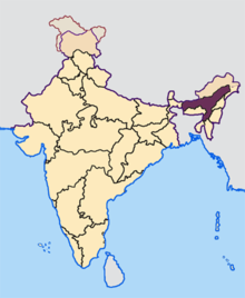
Dimasa Kingdom
The Dimasa Kingdom[4][5] (Hidimbā kingdom) was a powerful kingdom in Assam, Northeast India ruled by Dimasa kings,[6][7][8] called Timisa in the Ahom Buranjis.[9] The Dimasa kingdom and others (Kamata, Chutiya) that developed in the wake of the Kamarupa kingdom were led by chieftains of indigenous communities of Assam and are examples of indigenous state formations in Medieval Assam.[10] The British finally annexed the kingdom: the plains in 1832[11] and the hills in 1834.[12] This kingdom gave its name to undivided Cachar district of colonial Assam. And after independence the undivided Cachar district was split into three districts in Assam: Dima Hasao district (formerly North Cachar Hills), Cachar district, Hailakandi district.
Dimasa Kingdom | |||||||||
|---|---|---|---|---|---|---|---|---|---|
| 13th century CE–1832 | |||||||||
| Capital | Dimapur, Maibong, Khaspur | ||||||||
| Government | Tribal Monarchy | ||||||||
| Historical era | Medieval India | ||||||||
• Established | 13th century CE | ||||||||
• Annexed to British India | 1832 | ||||||||
| |||||||||
| Part of a series on the |
| History of Assam |
|---|
 |
|
Proto-historic |
|
Late Medieval |
|
Modern |
|
Contemporary |
| Categories |
|
| Part of a series on the |
| Culture of Assam |
|---|
 |
|
Proto-historic
Classical Medieval
Modern |
|
|
|
Festivals
|
|
Religion Major
Others |
|
History
Archives
Genres
Institutions Awards |
|
Music and performing arts |
|
Media |
|
Symbols
|
In the 18th century, a divine Hindu origin was constructed for the rulers of the Kachari kingdom and it was named Hidimba, and the kings as Hidimbesvar.[13] The name Hiḍimbā continued to be used in the official records when the East India Company took over the administration of Cachar.[14]
Origins
The origin of the Kachari Kingdom is not clear.[15] According to tradition the Dimasa had their domain in Kamarupa and their king belonged to a lineage called Ha-tsung-tsa or Ha-cheng-sa,[16] a name first mentioned in a coin from 1520.[17] Some of them had to leave due to a political turmoil and while crossing the Brahmaputra some of them were swept away[18]—therefore, they are called Dimasa ("son of the big river"). The similarity in Dimasa traditions and religious beliefs with those of the Chutiya kingdom supports this tradition of initial unity and then divergence.[19] Linguistic studies too point to a close association between the Dimasa language and the Moran language that was alive till the beginning of the 20th-century, suggesting that the Dimasa kingdom had an eastern Assam presence before the advent of the Ahoms.[20] The Dimasas had a tradition of worshiping Kechai Khaiti, the war goddess common among all Bodo-Kachari peoples:[21] as the Rabhas,[22][23] Tiwas, Koch,[24] Chutias,[25] etc.[26] According to an account in a Buranji, the first Ahom king Sukaphaa (r. 1228–1268) encountered them in the Tirap region (currently in Arunachal Pradesh), soon after they had to leave a place called Mohung (salt springs) losing it to the Nagas, which supports a tradition that eastern boundary of their domain extended up to Mohong or Namchang (near Jeypore, Assam) beyond the river Dichang.[27]
According to legend Hachengsa (or Hasengcha) was an extraordinary boy brought up by a tiger and a tigress in a forest near Dimapur who replaced the existing king following divine oracles; which likely indicates the emergence of a strong military leader able to consolidate power.[28] Subsequently, the Hasengcha Sengfang (clan) emerged and beginning with Khorapha (1520 in Dimapur),[29] the Dimasa kings continued to draw lineage from Hachengcha in Maibong and Khaspur till the 19th century.[30] This legend of the origin of Hachengcha is recorded in an unpublished manuscript written by the late Rajkumar Janmejoy Barman, a member of the royal clan of the Dimasas.
At Kachomari
From archaeological evidence and Kachari Buranjis record, First capital Laksmindrapur is doubtlessly accepted as Kachomari.[31]
At Dimapur
By the 13th century, the Kachari kingdom extended along the southern banks of Brahmaputra River, from Dikhow river to Kallang River and included the valley of Dhansiri and present-day Dima Hasao district.[32] Dimapur was built by Raja Chakradhvaj after being driven from Ghergaon in Jorhat district.[33] According to the Buranjis (that called the kings khun timisa[34]), the Kachari settlements to the east of Dhansiri withdrew before the Ahom advance.[35] The Chutiya Kingdom existed in the Northeast and the Kamata Kingdom and the Baro-Bhuyans to its west.
In Dimapur, the remains of the Kachari city are still evident. The locals around Dimapur refer to the remains as the "Chess Pieces" of Dima Raja or the King of Dimasa. "A few ancient temples only in upper Assam were then built of masonry, whereas the remains at Dimapur, for instance, which flourished centuries before the Ahoms arrived, show us that Kacharis knew all about the art of brick making and permanent buildings."[36]
China Ming dynasty has political interactions with Dimasa Kingdom,[37] Ming dynasty canonized Dimasa as a tusi in 1406, which named Dimasa Xuanwei Si (Chinese: 底马撒宣慰司).[38]
Hostilities with Ahoms
The Ahoms settled into the track between the Chutiya and the Kachari Kingdoms that was inhabited by the Borahi and Moran people. The first clash with the Ahom Kingdom took place in 1490, in which the Ahoms were defeated. The Ahoms pursued peace, and an Ahom princess was offered to the Kachari king and the Kachari took control of the land beyond the Dhansiri. But the Ahoms were getting powerful and pushed the Kacharis back west. In 1526 the Kacharis defeated the Ahoms in a battle, but in the same year, they were defeated in a second battle. In 1531 the Ahoms advanced up to Dimapur, the capital. The Dimasas in accordance to their animistic faith believes cows (Mushu) to be "Gushu" (impure). This belief is still held by the Dimasas. When the Ahom army attacked the Kachari's army, they took the cover of cows. The king of the Kachari Kingdom along with his mother and many royals were murdered after the Ahoms reached the city. The Ahoms later installed Detsung as the king of the Kachari Kingdom with yearly taxes of 20 Elephant and 1 lakhs of rupees (mudras). But in 1536 the Ahoms attacked the Kachari capital once again and sacked the city. The Dimasa abandoned Dimapur and retreated south to set up their new capital in Maibang. "Mai" means "Paddy" and "bang" means "Plenty or abundance".
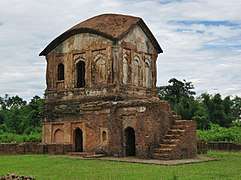
At Maibang
At Maibang, the Dimasa Kachari kings came under Brahmin influence.[39] The son of Detsung took a Hindu name, Nirbhay Narayan (Sankritised name), and established his Brahmin guru as the Dharmadhi that became an important institution of the state. The titular deity of the Dimasas changed from Kechai Khaiti to Ranachandi in the 16th-century as a result of Hinduisation.[40] The royal family came under Hindu influence at Maibang, though the first conversion of a Kachari king to Hinduism is recorded in Khaspur, much later.[41] According to a legend constructed at the time, the royal family descends from Ghatotkacha, the son of Bhima of the Mahabharata fame, and Hidimbi, a princess of the Kachari people.[42]
Chilarai attacked the kingdom on or after 1564,[43] during the reign of either Durlabh Narayan or his predecessor, and made it into a tributary of the Koch Kingdom. The size of the annual tribute— seventy thousand rupees, one thousand gold mohurs and sixty elephants[43]— testifies to the resourcefulness of the Kachari state.
A conflict with the Jaintia Kingdom over the region of Dimarua led to a battle and the defeat of the Jaintia king (Dhan Manik). After the death of Dhan Manik, Satrudaman the Dimasa Kachari king, installed Jasa Manik on the throne who manipulated events to bring the Dimasa Kacharis into conflict with the Ahoms once again in 1618. Satrudaman, the most powerful Dimasa Kachari king, ruled over Dimarua in Nagaon district (long before it was ruled by Tiwa tribal chief (Jongal Balahu), North Cachar, Dhansiri valley, plains of Cachar and parts of eastern Sylhet. After his conquest of Sylhet, he struck coins in his name.
By the reign of Birdarpan Narayan (reign around 1644), the Kachari rule had withdrawn completely from the Dhansiri valley and it reverted to a jungle forming a barrier between the kingdom and the Ahom kingdom.[44] When a successor king, Tamradhwaj, declared independence, the Ahom king invaded Maibong and destroyed its forts in 1706 and the king had to take refuge in Khaspur.[45]
State structure
Kacharis had three ruling clans (semfongs): Bodosa (an old historical clan), Thaosengsa (the clan to which the kings belonged), and Hasyungsa (to which the kings relatives belonged).[46]
The king at Maibang was assisted in his state duties by a council of ministers (Patra and Bhandari), led by a chief called Barbhandari. These and other state offices were manned by people of the Dimasa group, who were not necessarily Hinduized. There were about 40 clans called Sengphong of the Dimasa people, each of which sent a representative to the royal assembly called Mel, a powerful institution that could elect a king. The representatives sat in the Mel mandap (Council Hall) according to the status of the Sengphong and which provided a counterfoil to royal powers.
Over time, the Sengphongs developed a hierarchical structure with five royal Sengphongs though most of the kings belonged to the Hacengha (Hasnusa) clan. Some of the clans provided specialized services to the state ministers, ambassadors, storekeepers, court writers, and other bureaucrats and ultimately developed into professional groups, e.g. Songyasa (king's cooks), Nablaisa (fishermen).
By the 17th century, the Dimasa Kachari rule extended into the plains of Cachar. The plains people did not participate in the courts of the Dimasa Kachari king directly. They were organized according to khels, and the king provided justice and collected revenue via an official called the Uzir. Though the plains people did not participate in the Dimasa Kachari royal court, the Dharmadhi guru and other Brahmins in the court cast a considerable influence, especially with the beginning of the 18th century.
At Khaspur
The region of Khaspur was originally a part of the Tripura Kingdom, which was taken over by Chilarai in the 16th century. The region was ruled by a tributary ruler, Kamalnarayana, the brother of Chilarai. In the middle of the 18th century, the last of the Koch rulers died without an heir and the control of the kingdom went to the ruler of the Dimasa Kachari Kingdom as dowry. After the merger, the capital of the Dimasa Kachari Kingdom moved to Khaspur, near present-day Silchar. In the 18th-century, the Hailakandi region was annexed to the Kachari kingdom.
Sanskritization
The fictitious but widely believed legend that was constructed by the Hindu Brahmins at Khaspur goes as follows:[47] During their exile, the Pandavas came to the Kachari Kingdom where Bhima fell in love with Hidimbi (sister of Hidimba). Bhima married princess Hidimbi according to the Gandharva system and a son was born to princess Hidimbi, named Ghatotkacha. He ruled the Kachari Kingdom for many decades. Thereafter, kings of his lineage ruled over the vast land of the "Dilao" river ( which translates to "long river" in English), now known as Brahmaputra River for centuries until 4th century AD. It is believed that Kacharies participated in the Mahabharata war too.
British occupation
The Dimasa Kachari kingdom came under Burmese occupation in the late early 19th-century along with the Ahom kingdom. The last king, Govinda Chandra Hasnu, was restored by the British after the Yandaboo Treaty in 1826, but he was unable to subjugate Tularam Senapati who ruled the hilly regions. Senapati Tularam Hasnusa domain was Mahur River and the Naga Hills in the south, the Doyang river on the west, the Dhansiri River on the east and Jamuna and Doyang in the north. In 1830, Govinda Chandra Hasnu died. In 1832, Senapoti Tularam Hasnu was pensioned off and his region was annexed by the British to ultimately become the North Cachar district; and in 1833, Govinda Chandra's domain was also annexed to become the Cachar district.[48]
After Gobinda Chandra Hasnu
In the early nineteenth century, after being dislodged from Meitrabak (present-day Manipur), its princes made Cachar a springboard for the reconquest of the territory. In 1819, three brothers occupied Cachar and drove Govinda Chandra Hasnu out to Sylhet (now in Bangladesh). The kingdom of Cachar, divided between Govinda Chandra Hasnu and Chaurajit in 1818, was repartitioned after the flight of Govind Chandra among the three Meitrabak princes. Chaurajit got the eastern portion of Cachar bordering Meitrabak which was ruled from Sonai. Gambhir Singh was given the land west of Tillain hill and his headquarters was at Gumrah, Marjit Singh ruled Hailakandi from Jhapirbond. The British annexed the Dimasa Kachari Kingdom under the doctrine of lapse. At the time of British annexation, the kingdom consisted of parts of Nagaon and Karbi Anglong; North Cachar (Dima Hasao), Cachar and the Jiri frontier of Manipur.
Rulers and Kings
| Capital | King | Date of Accession | Reign in Progress | End of reign |
|---|---|---|---|---|
| Dimapur | Bicharpatipha[50] | |||
| Vikramadityapha[50] | ||||
| Mahamanipha | ||||
| Manipha | ||||
| Ladapha | ||||
| Khorapha | 1520? | 1526 | ||
| Khuntara | 1526 | 1531 | ||
| Detsung/Dersung | 1531 | 1536 | ||
| Interregnum? | ||||
| Maibong | Nirbhay Narayan | 1558? | 1559 | |
| Durlabh Narayan | ||||
| Megha Narayan | 1568 | 1578 | 1583? | |
| Yasho Narayan (Satrudaman) | 1583? | 1601 | ||
| Indrapratap Narayan | 1601 | 1610 | ||
| Nar Narayan | ||||
| Bhimdarpa Narayan | 1618? | |||
| Indraballabh Narayan | 1628 | 1644? | ||
| Birdarpa Narayan | 1644? | 1681 | ||
| Garurdhwaj Narayan(Thaosen Clan) | 1681 | 1695 | ||
| Makardhwaj Narayan( Thaosen Clan) | 1695 | |||
| Udayaditya(Thaosen Clan) | ||||
| Tamradhwaj Narayan( Thaosen Clan/Sengphong) | 1706 | 1708 | ||
| Suradarpa Narayan ( Thaosen clan/Sengphong) | 1708 | |||
| Harischandra Narayan -1 (Thaosen Sengphong) | 1721 | |||
| Kirtichandra Narayan( Hasnusa Sengphong) | 1736 | |||
| Sandikhari Narayan alias Ram Chandra) | 1736 | |||
| Khaspur | Harischandra-2 (Hasnusa Sengphong) | 1771 | ||
| Lakshmichandra Narayan | 1772 | |||
| Krishnachandra Narayan | 1790 | 1813 | ||
| Govindachandra Narayan | 1814 | 1819 | ||
| Chaurajit Singh (from Manipur) | 1819 | 1823 | ||
| Gambhir Singh (from Manipur) | 1823 | 1824 | ||
| Govindachandra Narayan | 1824 | 1830 | ||
| British Annexation | 1832 |
Notes
- "639 Identifier Documentation: aho – ISO 639-3". SIL International (formerly known as the Summer Institute of Linguistics). SIL International. Retrieved 2019-06-29.
Ahom [aho]
- "Population by Religious Communities". Census India – 2001. Ministry of Home Affairs, Government of India. Retrieved 2019-07-01.
Census Data Finder/C Series/Population by Religious Communities
- "Population by religion community – 2011". Census of India, 2011. The Registrar General & Census Commissioner, India. Archived from the original on 25 August 2015.
- "In the 13th century the Dimasa kingdom extended along the south bank of the Brahmputra, from Dikhou to Kallang and included the Dhansiri Valley and the North Cachar Hills, with its capital at Dimapur." (Bhattacharjee 1987:222)
- All the possibilities of the Kachari kingdom at Sadiya or some other places of Northeast India remain unproven theories until concrete evidence is provided. Therefore, as a term denoting this particular social group, I prefer Dimasa to Kachari in the following discussion.(Shin 2020:64)
- (Shin 2020:61)
- "In the 13th century the Dimasa kingdom extended along the south bank of the Brahmputra, from Dikhou to Kallang and included the Dhansiri Valley and the North Cachar Hills."; "During 16th to 18th century AD they established a State of their own which covered modern South Assam (Barak Valley, parts of Assam Valley and intervening North Cachar Hills) and some parts of Nagaland and Manipur." (Bhattacharjee 1987:222)
- "Dimasa conceive of themselves as the rulers and subjects of the Dimasa kingdom." (Ramirez 2007:93)
- "Ahom chronicals attest the existence of "Timisa kings" (khun-timisa) who ruled over a large area of middle Assam, initially from Dimapur on the western foothills of present-day Nagaland." (Ramirez 2007:93)
- "During the 13th-16th centuries, while these continued to represent the rule over older peasant settlements in western and central Assam, there emerged alongside them also new kingdoms from several tribal bases, then undergoing a process of politico-economic transformation. These kingdoms did not represent mere dynastic changes in an ongoing political sobiety. Rather, they were almost new state formations in a seemingly political vacuum. The Chutiya, Ahom, Dimasa, Jaintia and Koch states were such formations." (Guha 1983:10)
- (Banerjee 1990:69)
- (Banerjee 1990:91)
- (Chatterji 1951:123–124)
- (Shin 2020:70)This is clear from a seal of the Superintendent of the District of Cachar of 1835. See Gait, Report on the Progress of Historical Research in Assam, p. 10.
- (Bhattacharjee 1992:392–393)
- "(T)he Kacharis of North Cachar believe that they once ruled in Kamarupa and their royal family traced its descent from the Rajas of that country, from the line of Ha-tsung-tsa." (Baruah 1986:187–188)
- "[the coin struck by Vīravijayanārāyaṇa, dated 1442 Śaka (1520 ad)] bears the legend describing the king as ‘a worshipper at the feet of the goddess Chandī and a subduer of the foes of Hāchengsā’."(Shin 2020:63)
- "The tradition current among the Dimasas of Cachar mention their kingdom in ancient Kamarupa and how during a political turmoil they had to cross the big river (Brahmaputra; Dilao) and a large section of their people were washed away." (Bhattacharjee 1992:392–393)
- "(That the Chutiyas and Sadiyal Kacharis were identical) is also supported by the similarities in traditions and religious beliefs associated with both the tribes." (Baruah 1986:187)
- "(B)y demonstrating that these people spoke a Dimasa dialect, we also show that a large part of Upper Assam spoke ancient Dimasa." (Jaquesson 2017:108)
- Kechai Khati worshipped by Bodo-kacharis
- Rabhas worship Kechai-khati and celebrate the Kechai-khati festival once every year
- Kechai-khati festival of Rabhas
- The Tiwas, as well as the Koch, also worshipped Kechai Kati. The Koch general Gohain Kamal built temples dedicated to Kesai Khati in Khaspur for the Dehans who were Tiwa and Mech soldiers from Gobha, Nellie and Kabi.
- Kechai-khati worship of Chutias
- "There is at Sadiya a shrine of Kechai Khaiti the tutelar deity of the Kacharis, which the Dimasa rulers continued to worship even after the establishment of their rule in Cachar." (Bhattacharjee 1992:393)
- (Baruah 1986:188)
- (Shin 2020:63–64)
- " The very first example comes from the coin struck by Vīravijayanārāyaṇa, dated 1442 Śaka (1520 ad). It bears the legend describing the king as ‘a worshipper at the feet of the goddess Chandī and a subduer of the foes of Hāchengsā’. Vīravijayanārāyaṇa is a name apparently unrecorded in other sources, but Rhodes considers that it was probably the Sanskrit name adopted by Dimasa king Khorapha, who was killed during the Ahom invasion in 1526." (Shin 2020:63)
- (Shin 2020:64)
- (Sarma 2016:74)
- (Bhattacharjee 1987:222)
- (Sarma 2016:76–77)It was built by Chokrodoz (Chakradhvaj), 4th raja of Cachar but long subsequent to the erection of ghergong in the jorhat district
- (Ramirez 2007:93)
- "(P)robably in the reign of the second Ahom king Sutepha (1268–81), the outlying Dimasa settlements, east of the Dikhu river, withdrew before the advance of the Ahoms." (Shin 2020:62)
- Shakespear, Leslie (2012). History of Upper Assam, Upper Burmah and North-Eastern Frontier. Cambridge University Press. p. 13. ISBN 978-1-108-04607-7.
- Seshan, Radhika (2017). Narratives, Routes and Intersections in Pre-Modern Asia. Routledge India. ISBN 9781138688582.
- Taizong Shilu Volume 55.
(永乐四年六月壬午)以大古剌底马撒二处地广各置宣慰使司……以泼的那浪为大古剌宣慰使腊罔帕为底马撒宣慰使
- "It was (at Maibong) that the Dimasa state formation process entered into a crucial phase under Brahmanical influence." (Bhattacharjee 1987:222)
- "Another significant development in the process of Hinduisation of the royal family and the aristocracy was the transformation of the titular deity Kechai Khaiti to Ranachandi." (Bhattacharjee 1992:394)
- (Rhodes 1986:166)
- (Bhattacharjee 1992:394)
- (Sarkar 1992:83)
- "By this time the Kacharis had completely withdrawn from the Dhansiri Valley, which had reverted into the jungle, forming a natural barrier between the Ahoms and the Kacharis. The Ahoms still, however, regarded the Kacharis as being a subject nation." (Rhodes 1986:164)
- "...but when the next king, Tamradhvaja, boldly proclaimed his independence, the Ahom King Rudra Simha invaded Kachar in December 1706. Tamradhvaja could offer little resistance, and Maibong was soon occupied and its fort demolished." (Rhodes 1986:165)
- "Those Kachari clans which were most closely connected with the raja and his entourage were the first to rise to dominant positions. They were the Bodosa, the most senior, known as the former ruling clan; the Thaosengsa, the clan to which the ruling dynasty belonged in the period for which data are available; the Hasyungsa, the clan of the king's relatives (Crace 1930)."(Maretina 2011:343)
- "Thus it is clear that this is an invented tradition by the Brahman pundits in the later stage of the monarchy in the Cachar plains. Although this is fictitious, people within the community strongly believe in this story of their ancestry." (Bathari 2014:17–18)
- (Bose 1985, p. 14)
- (Rhodes 1986:167)
- Not mentioned in the list of kings in (Rhodes 1986)
References
- Banerjee, A C (1990), "Reform and Reorganization: 1932-3", in Barpujari, H K (ed.), The Comprehensive History of Assam, IV, Guwahati: Publication Board, Assam, pp. 44–76CS1 maint: ref=harv (link)
- Sarma, Pradip (2016), Megalithic Splendours of the Dhansiri Valley of Northeast India (book), Chennai: Notion Press, ISBN 9781946129383CS1 maint: ref=harv (link)
- Barpujari, S. K. (1997), History of the Dimasas (from the earliest times to 1896 AD), Haflong
- Baruah, S L (1986), A Comprehensive History of Assam (book), New Delhi: Munshiram Manoharlal PublishersCS1 maint: ref=harv (link)
- Bathari, Uttam (2014). Memory History and polity a study of dimasa identity in colonial past and post colonial present (Ph.D.). Gauhati University. hdl:10603/115353.CS1 maint: ref=harv (link)
- Bhattacharjee, J. B. (1992), "The Kachari (Dimasa) state formation", in Barpujari, H. K. (ed.), The Comprehensive History of Assam, 2, Guwahati: Assam Publication Board, pp. 391–397
- Bhattacharjee, J B (1987). "The Economic Content of the Medieval State Formation Processes among the Dimasas of North East India". Proceedings of the Indian History Congress. 48: 222–225. JSTOR 44141683.CS1 maint: ref=harv (link)
- Bose, Manilal (1985), Development of Administration in Assam, Assam: Concept Publishing Company
- Chatterji, S. K. (1951), "The Hidimba (Dima-sa) people", Kirata-Janakrti, The Asiatic Society, pp. 122–126
- Gait, Edward A. (1906), A History of Assam, Calcutta
- Guha, Amalendu (December 1983), "The Ahom Political System: An Enquiry into the State Formation Process in Medieval Assam (1228-1714)", Social Scientist, 11 (12): 3–34, doi:10.2307/3516963, JSTOR 3516963
- Jaquesson, François (2017). Translated by van Breugel, Seino. "The linguistic reconstruction of the past The case of the Boro-Garo languages". Linguistics of the Tibeto-Burman Area. 40 (1): 90–122. doi:10.1075/ltba.40.1.04van.
- Maretina, Sofia A. (2011), "The Kachari state: The character of early state-like formations in hill districts of Northeast India", in Claessen, Henri J. M. (ed.), The Early State, 32, Walter de Gruyter, pp. 339–359, ISBN 9783110813326
- Ramirez, Philippe (2007), "Politico-ritual variations on the Assamese fringes: Do social systems exist?", in Sadan, Mandy; Robinne., François (eds.), Social Dynamics in the Highlands of Southeast Asia Reconsidering Political Systems of Highland Burma, Boston: Brill, pp. 91–107
- Rhodes, Nicholas G.; Bose, Shankar K. (2006), A History of the Dimasa-Kacharis As Seen Through Coinage, Mira Bose, Library of Numismatic Studies, Kolkata and Guwahati
- Rhodes, N G (1986). "The Coinage of Kachar". The Numismatic Chronicle. 146: 155–177. JSTOR 42667461.CS1 maint: ref=harv (link)
- Sarkar, J. N. (1992), "Early Rulers of Koch Bihar", in Barpujari, H. K. (ed.), The Comprehensive History of Assam, 2, Guwahati: Assam Publication Board, pp. 69–89
- Shin, Jae-Eun (2020). "Descending from demons, ascending to kshatriyas: Genealogical claims and political process in pre-modern Northeast India, The Chutiyas and the Dimasas". The Indian Economic and Social History Review. 57 (1): 49–75. doi:10.1177/0019464619894134.CS1 maint: ref=harv (link)
| ||
| Protohistoric Assam |
|  |
| Ancient Assam | ||
| Medieval Assam |
| |
| Colonial Assam | ||
| Contemporary Assam | ||