Dimapur
Dimapur is a city in Nagaland, India. It is the most populous city in Nagaland and also the most densely populated city in the state with an estimated population of about 250,000. The city is the main gateway and commercial centre of Nagaland.
Dimapur | |
|---|---|
City and municipality | |
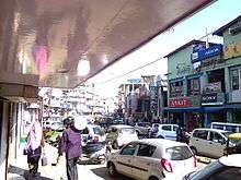
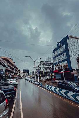 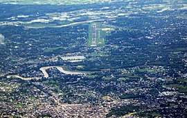 Dimapur Street (Top), Aerial view of Dimapur (Bottom) | |
 Dimapur  Dimapur | |
| Coordinates: 25.92°N 93.73°E | |
| Country | |
| State | |
| District | Dimapur |
| Government | |
| • Deputy Commissioner | Shri Anoop Kinchi, IAS |
| Area | |
| • Total | 121 km2 (47 sq mi) |
| Elevation | 145 m (476 ft) |
| Population | 254,674 |
| • Rank | 1st in Nagaland |
| • Density | 2,558/km2 (6,630/sq mi) |
| Languages | |
| • Official | English and Nagamese |
| Time zone | UTC+5:30 (IST) |
| PIN | 797 112, 797103, 797113, 797115, 797116 |
| Telephone code | 91 - (0) 03862 |
| Vehicle registration | NL-07 |
| Website | dimapur |
Located near the border with Assam along the banks of the Dhansiri River, Dimapur is the only plains tract of hilly Nagaland and also has the only railway station and airport in the state for connectivity and economic activity.
Etymology
The name Dimapur is derived from the Kachari language; Di means "water", ma means "large" and pur (sanskritised word) means "city", translating to "Big-river-city", associated with the meaning of "Kachari" which is "people of the river valley" and after the river which flows through it (Dhansiri).
There are two accounts of the way in which Dimapur got its name : many writers are of the opinion that the name 'Dimapur' was derived from Dimasa Kachari words Di-meaning water, Ma-meaning big and Pur-meaning city or township in the Dimasa dialect; while others contend that Dimapur is a corruption of Hidimbapur, meaning the city of Hidimbi (of Mahabharata fame) - the rakshasi-turned-woman whose marriage to the Pandava prince Bhima led to the birth of Ghatotkacha, believed to be the progenitor of the Kacharis. According to the second theory, the name Hidimbapur is conjectured to have been abbreviated to Dimbapur and subsequently to have lost a consonant to become Dimapur. In the Ahom Chronicles, Dimapur Is referred to sometimes as ‘Che-din-chi-pen’ (town-earth-burn-make) meaning ‘brick town’.[2]
History
Situated on the banks of the Dhansiri (originally known as Dong-siri meaning a ravine of peaceful habitation), Dimapur, often described as the ‘Brick City’ by European scholars and also by the Ahoms, was the ancient capital of the Dimasa Kachari community and an independent nation of the Dimasa, who were once a powerful and predominant race in the entire North-East India region (Brahmaputra/Dilao Valley).
Medieval period
According to popular belief, the city's formation in Nagaland is separate from that of Assam. In the Middle Ages, it was the capital of the Kachari Kingdom. In the heart of the town there is an old relic of the Kachari Kingdom which speaks about the once prosperous era.
The seat of capital of Dimapur Kingdom was originally enclosed by a brick wall four feet wide and sixteen feet high, surrounded by an outer ditch sixteen feet in width and twelve feet in depth, except on the southern side where the River Dhansiri formed a natural moat. On the eastern side, there was a fine solid gateway with brick masonry of pointed double arches. The gate was secured by heavy double doors, the hinges of which were seated in holes pierced in solid stone blocks. At both ends of the battlement there were turrets of half quadrant shape and in between the archway and the turrets were niches resembling ornamental windows. High up, on either side of the arch, were carvings of sunflowers, which were originally faced with brass so as to present a dazzling spectacle when seen sparkling in the sun from afar. Edward Albert Gait said of the brick structures of Dimapur that they showed the Kacharis' civilization to be further advanced than that shown by the timber and mud plaster constructions of the Ahoms.[3] Dimapur marked a progressive point in the history of the lineage of the Mech/Mechha Dynasty (un-sanskritised heritage of the Kacharis).
Inside the fortified city, there were seventeen ornamental stone pillars. These funerary monuments were decorated with carvings of foliage, flowers, familiar animals and birds. These monoliths are believed to be lineal monuments of the ruling kings of Dimapur. The largest of them was seventeen feet high and twenty-four feet in circumference and was said to be the memorial of Makardhwaj, greatest of the rulers of Dimapur (to be equated probably with Khungkradoa Raja, in whose time the Dimasa Kachari Kingdom reached its apogee. It was during this golden age that the conquests of Manipur and Burma took place under the leadership of Sengyah (Veer) Demalu Kemprai, the greatest warlord of the Kacharis. Also during this period, heroes like Rangadao (after whom Ranga Pathar, the southern part of Dimapur, was named), Degadao and mystic heroines like Wairingma and Waibangma won renown in war and the pursuit of mystical attainment. Other V-shaped stone monuments, seventeen in number, symbolised the seventeen royal clans of the 'Dimasa Kachari Aristocracy’ a term coined by Dr. Francis Hamilton, a renowned scholar of the Dimasa Kachari Royal Clan.
Shri SK. Barpujari in his book History of the Dimasa and some other writers opined that the Dimasa Kachari Kings to commemorate their Victory over other tribesmen, erected monoliths of different shapes indicating the different traditions of the vanquished tribes. This tradition of carving victory memorials is part of the culture of the hill tribes and may have been adopted by the Dimasa Kachari Kings in order to demonstrate the legitimacy of their rule. Dr H. Bareh in the Gazetteer of India writes that the oblong V-Shaped stone pillars closely correspond to the similarly V-Shaped post protruding from the roof of the house of wealthy Angamis, who are said to have adopted the practice.
The tallest and largest megalith, which lies isolated from others and has a unique Sultanate style, is believed to have been erected by the founder king of Dimapur, who after vanquishing the tribes all around made his triumphal tower to commemorate his victory and this became a tradition setter. In and around this old city, large number of tanks over 50 in number existed, although most of them have since either dried up or have been destroyed by reckless human encroachment without an iota of respect for the history. These tanks are believed to be dug by the kings for providing water supply to their people. Most of large tanks are rectangular and have a hardwood seasoned poles planted deep at the centre of the tanks, which have lasted for hundreds of years. Others are of irregular shapes without any such wooden poles. Inference in that, the former ones might have been dug by the kings for water supply and the later were habitation as 'Digjo Dijua' meaning 'cut off from main river or stream’ and this tradition is still in vogue, and this area covers Dimapur and Dimasa Kachari inhabited areas of Karbi Anglong District of Assam in the Dhansiri Valley. The present Dimapur is the commercial capital of Nagaland and is one of the fastest growing townships in the entire North-east region. But irony is, in the name of the modernity and development, this ancient city of Dimapur, whose historical relics finds a place in the World.
1900
During World War II, Dimapur was the centre of action between British India and Imperial Japan. It was the staging post for the Allied offensive. The Japanese could reach Kohima where a siege was laid. Allied reinforcement came through Dimapur by rail and road for the push against the Japanese. An airport at Dimapur was also in use for supplies to the allied forces in Burma. The battle for Kohima about 77 km from Dimapur is considered the turning point for the Japanese retreat from South East Asia.
The Jains were amongst the earliest non-Naga settlers of Nagaland. A few Jain families came to Kohima in the 1880s and settled there. They later moved to Dimapur in 1944 due to Japanese invasion during World War II. Prominent among them were Phulchand Sethi, Udayram Chabra, Mangilal Chabra, Phulchand Binaykia, Jethmal Sethi, Ramchandra Sethi, Bhajanlal Sethi, Kanhaiyal Sethi, Nathmal Sethi etc. Phulchand Sethi, Bhajanlal Sethi and other Sethi and Chabra brethren set up the SD Jain Temple, SD Jain School, SD Jain Charitable Hospital. Kanhaiyalal Sethi, Phulchand Sethi, and his brothers also built the Durga Mandir in Old Daily Market.
Present-day Dimapur has far outgrown its old town area (up to the old Dhansiri bridge, under reconstruction in 2017). It is one contiguous urban sprawl from the Assam border at Dilai gate and newfield checkgate up to the foothills of Chümoukedima, the designated district headquarters of Dimapur district.
Political status of the Kacharis
After the statehood was given a new interim body was set up whereby the Kacharis were given representation in the form of membership in the government body. The Kacharis were asked to nominate their member a qualified person could be found and hence they brought in a person from the Bodo (Mech), sub-tribe of the Great Kachari Family, late Shri Deblal Mech (a Bodo Kachari), to represent the people. The Kacharis are mostly in the Dimapur III constituency of the state, where total voters would be around 20,000; these consist of Dimasa Kachari, Bodo/Mech Kachari, Garo, Kuki and others, including Naga tribes like Angamis, Kyong (Lotha), Chakhesangs, Sumis, etc. Dimasas Kacharis or Kacharis honestly enrolled in the electoral roll the exact eligible voters whereas many other communities inflated their numbers very largely. At present, Dimasa Kacharis' live alongside other Kachari sub-tribes and the Naga community in Dimapur, and the Kachari community as a whole is considered as one of the indigenous community of Nagaland. The Kacharis are mostly found in the Dhansiripar Subdivision, Kachari Gaon, Diphupar, Ranga Pathar, etc.
Geography
Dimapur is located in the southwest of Nagaland. The vast majority of this area is flat with the Dhansiri River, a tributary of the Brahmaputra River flowing east of the city.
Climate
Dimapur is hot and humid in summers and moderately cold in winters.[4]
| Climate data for Dimapur | |||||||||||||
|---|---|---|---|---|---|---|---|---|---|---|---|---|---|
| Month | Jan | Feb | Mar | Apr | May | Jun | Jul | Aug | Sep | Oct | Nov | Dec | Year |
| Average high °C (°F) | 22.7 (72.9) |
24.5 (76.1) |
26.9 (80.4) |
27.2 (81.0) |
29.9 (85.8) |
31.5 (88.7) |
32.3 (90.1) |
33.5 (92.3) |
33.7 (92.7) |
30.9 (87.6) |
25.0 (77.0) |
24.4 (75.9) |
28.5 (83.4) |
| Average low °C (°F) | 9.8 (49.6) |
13.1 (55.6) |
18.6 (65.5) |
22.3 (72.1) |
21.6 (70.9) |
22.5 (72.5) |
23.7 (74.7) |
24.6 (76.3) |
25.2 (77.4) |
21.0 (69.8) |
14.5 (58.1) |
13.1 (55.6) |
19.2 (66.5) |
Demographics
As of 2011 the census of 2011 the city-population of the old Town Committee area (up to the old dhansiri bridge) at 122,834. Males constitute 52% of the population and females 48%. Dimapur has an average literacy rate of 86% male literacy is 88% and, female literacy is 84%.[1] In Dimapur, 12% of the population is under 6 years of age. Unlike other places in the state, this city has a heterogeneous mix of people from all over India, and for which it is also known as "mini India."
Besides the dominant Naga tribes who comprise about 50% of the city's population, other prominent groups include Bengalis, Assamese, Oriyas, Nepalese, Biharis, Meiteis, Kacharis, Kukis, Marwaris, Punjabis and also Tamils and Keralites. In the last two decades Tibetan traders have also settled in the city.
Religion
Christianity is the most popular religion in Dimapur, making up 45% of the city population and Hinduism nearly as popular at 41% of the population. Islam is followed by 11%, and Jainism by 1.7%.[1]
Tourism
Religious and historical sites
- Ruins of Kachari Rajbari
.jpg)
Although is left in ruins after centuries of abandonment, after facing conflict with the Ahom King in 18th century and with the settlement of township occupying almost half of its former glorious fortress, is still a national heritage site. It signifies great historical importance for the region of North-East. It also gives great value to the state of Nagaland.
- Dimapur Jain Temple
The Dimapur Jain Temple was built in 1947. The temple has some intricate glass work. The temple is considered very auspicious by the people of Dimapur. The temple was built by the tireless effort of Shri Subhkaran Sethi, Shri Phulchand Sethi, Shri Jethmal Sethi, Shri Udayram Chabra, Shri Chunnilal Kishanlal Sethi, Shri Kanhaiyal Sethi, and other Jain families present in Dimapur at that time.
Parks and other highlights
Dimapur has several places where tourist can visit such as Green Park, Aqua Mellow park, Zoological Garden, Science Center, Stone Park, Hazi Park, Agri Expo site, Rangapahar Forest, Triple Falls, Shiv Mandir, Loinloom Festival and Kali Temple.[5]
Transportation
Roadways
Highways passing through Dimapur


Airport
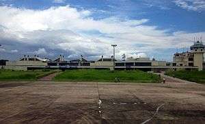
Dimapur is served by the Dimapur Airport which is located at 3rd mile (AH-1). It is the only civil airport in the state and operates routes to Kolkata, Guwahati, Imphal,[6] and Dibrugarh.
There are plans for expansion of the airport to meet international norms by buying land at Aoyimti village.
Railway
Dimapur is the only city in Nagaland that is connected by both rail and air. There are direct train services to cities like Guwahati, Kolkata, New Delhi, Bangalore, Chandigarh, Amritsar, Dibrugarh and Chennai from the Dimapur railway station. The station is categorised as an A category railway station which lies on the Lumding-Dibrugarh section under the Lumding railway division of Northeast Frontier Railway.
Economy
Although Dimapur accounts for only about 9% of the state, it is the commercial centre of Nagaland.
Commerce
A number of shopping centers and markets have sprung up in Dimapur, with the Hong Kong Market, Central Plaza, New Market, Bank colony (Super Market Area) and Circular and NL roads serving as the main commercial areas in the city. The Complexes and shopping centres have sprung up to Nuton Bosti.
The stretch from Purana Bazar to Chümoukedima along the AH-1 is also rapidly developing into commercial areas.
The city's Hong Kong Market is well known for imported goods from Thailand, China, and Burma and is the main Shopping Attraction for Tourists visiting Nagaland. The wholesale foodgrain items are available at KL Sethi Market Complex, Jasokie Market etc. at G S Road, Dimapur.
Industry
The Nagaland Industrial Growth Centre is situated at Ganeshnagar of Dhansiripar Sub-Division, where most of the Dimasa Kacharis lived — an area consisting of seven Dimasa Villages (Dhansiripar, Disaguphu, Amaluma, Doyapur, Ganeshnagar, Hazadisa, and Manglumukh).
Education

Universities and colleges
- Tetso College[7]
- Patkai Christian College
- Dimapur Government College
- National Institute of Technology Nagaland
- St. Joseph University
- Global Open University
- ICFAI University, Nagaland
See also
- Battle of Kohima
- Battle of the Tennis Court
- Chümoukedima
- Indian XXXIII Corps
- Nagaland
- Nagaland Page
- Northeast Indian Railways during World War II
References
- "Dimapur City Population Census 2011 | Nagaland". www.census2011.co.in.
- "SALESIAN PROVINCE OF DIMAPUR". donboscodimapur.org. Archived from the original on 24 March 2014. Retrieved 18 February 2014.
- Gait, Edward Albert (1906). A History of Assam. Calcutta: Thacker, Spink & Co. pp. 244–245. ISBN 1375513508.
- "February Climate History for Dimapur". myweather2.com. Retrieved 18 February 2014.
- "Dimapur Places to Visit". holidayiq.com. Retrieved 18 February 2014.
- "Alliance Air confirms plans to commence Guwahati-Dimapur-Imphal service in Dec-2019". CAPA. Retrieved 4 December 2019.
- Lyndem, Biloris; De, Utpal Kumar (2004). Education in North East India: Experience and Challenge. Concept Publishing Company. p. 346. ISBN 9788180690631. Retrieved 9 December 2016.
External links
| Wikimedia Commons has media related to Dimapur. |