Digapahandi
Digapahandi (formerly known as Bada Khemundi) is a town and a Notified Area Council (N.A.C.) in Ganjam district in the state of Odisha, India. There are 171 small villages which comes under Digapahandi tahasil and largely dependent on this town for their business and livelihood. Digapahandi town is divided into 11 wards, comprising Bazar street, Sunari street, New street, Phulasundari Street, Balaji Nagar Bada Brahmin street, Sana Brahmin street, Sasan street, Chikitia street, Rani street, Annapurna street, Anchala street, Uparabasa, Chikiti road etc.
Digapahandi Bada Khemundi Bada Khemundi | |
|---|---|
NAC | |
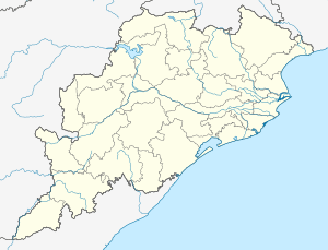 Digapahandi Location in Odisha, India  Digapahandi Digapahandi (India) | |
| Coordinates: 19.37°N 84.58°E | |
| Country | |
| State | Odisha |
| District | Ganjam |
| Government | |
| • Type | NAC |
| • Body | Digapahandi Notified Area Council |
| Elevation | 53 m (174 ft) |
| Population (2011) | |
| • Total | 125,382 |
| Languages | |
| • Official | Odia |
| Time zone | UTC+5:30 (IST) |
| PIN | 761012 |
| Telephone code | 06814 |
| Vehicle registration |
|
| Website | odisha |
Geography
Digapahandi is located at 19.37°N 84.58°E.[1] It has an average elevation of 53 metres (173 feet).
Demographics
As of 2011 India census, The Digapahandi Notified Area Committee has the population of 13,190 of which 6,679 are males while 6,511 are females. The population of Children with age of 0-6 is 1454 which is 11.02% of total population of Digapahandi (NAC). The literacy rate of Digapahandi city is 78.36% higher than the state average of 72.87%. In Digapahandi, Male literacy is around 85.61% while female literacy rate is 70.98%.
Economy
Most families of this town depend on their business. Some people are cultivators/farmer & teachers. There are no big industries in this area, 20-30 Granite industries are there. This is a junction (Punjikayaan) for the state highways (29 & 17) Sh17 and Nh326 runs on same road.
Education
The town has two government high schools namely Bada Khemundi High School for boys and Govt. Girls High School. The two colleges here are Khemundi college and Biju Patnaik Women's College. Besides, there is a Central School at Digapahandi. There are about 20 numbers of primary / M.E schools. There are 3 Sishu Mandir's from which one of the Sishu Mandir is under Sikshya Bikash Samiti that consist of classes from 1st to 10th class. Bina Pani nursery school is the oldest (1986) English/Odia primary school consist lkg to STD 5th
Politics
BJP, BJD & INC are the major political parties in this area. See Digapahandi (Odisha Vidhan Sabha constituency).
Facilities
The town has one tehsil office, one block office, one JMFRC court, two post offices, one government hospital, one police station, one fire station, one irrigation office, one fishery office, one veterinary, one govt guest house, one sub jail, one excise office & banks namely SBI, Canara, Andhra, BOI, Axis, Baroda etc.
Places of interest
The Ujjaleswar Temple situated nearly 19 km from Digapahandi. The shrine of Ujjaleswar has been developed from a cave temple, on a hillock which is approachable by steps. A huge stone shadowing the deity forms the back side of the temple, which has been also chiseled to steps for facilitating a circumambulating around the shrine.
References
External links
Capital: Bhubaneswar | |||||||
| Governance |
|  | |||||
| Topics | |||||||
| GI products | |||||||
| Districts by division |
| ||||||
| Cities | |||||||