Balasore district
Balasore District also known as Baleswar District or Baleshwar District, is an administrative district of Odisha state in eastern India. Balasore is one of the coastal Districts of Odisha. It lies on the northernmost part of the state. It was a part of the ancient Kalinga which later became a territory of Toshal or Utkal.
Balasore District | |
|---|---|
 Chandipur Beach | |
| Nickname(s): Granary of Odisha | |
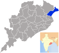 Location in Odisha, India | |
| Coordinates: 21.5°N 86.9°E | |
| Country | India |
| State | Odisha |
| Headquarters | Balasore |
| Government | |
| • Collector & District Magistrate | Shri K Sudarshan Chakravarty, IAS |
| • Superintendent of Police | Shri Banoth Jugal Kishore Kumar, IPS |
| Area | |
| • Total | 3,634 km2 (1,403 sq mi) |
| Elevation | 90.08 m (295.54 ft) |
| Population (2011[1]) | |
| • Total | 2,320,529 |
| • Rank | 4 |
| • Density | 609/km2 (1,580/sq mi) |
| Languages | |
| • Official | Odia, English |
| Time zone | UTC+5:30 (IST) |
| PIN | 756 xxx |
| Telephone code | 06782 |
| Vehicle registration | OD-01 |
| Coastline | 81 kilometres (50 mi) |
| Sex ratio | 957 ♂/♀ |
| Literacy | 80.66% |
| Climate | Aw (Köppen) |
| Precipitation | 1,583 millimetres (62.3 in) |
| Avg. summer temperature | 43.1 °C (109.6 °F) |
| Avg. winter temperature | 10.6 °C (51.1 °F) |
| Website | baleswar |
| General Information | |
|---|---|
| Name of Parliamentary Constituency: | Balasore |
| No. & Name of Assembly Constituency: | 035-Jaleswar 036-Bhograi 037-Basta 038-Balasore 039-Remuna(SC) 040-Nilgiri 041-Soro(SC) 042- Simulia |
| Sub-Division: | 2 (Balasore, Nilgiri) |
| Block: | 12 |
| Tahasil: | 12 |
| Municipality: | 3 |
| N.A.C.: | 1 |
| Gram Panchayat: | 289 |
| Village: | 2971 |
Geography
| This article is part of a series on |
| Odisha |
|---|
 |
| Governance |
|
| Topics |
| GI Products |
|
|
Districts Divisions |
|
|
Balasore district is located in the northeast of the state of Odisha and lies between 21° 3' to 21° 59' north latitude and 86° 20' to 87° 29' east longitude. The average altitude of the district is 19.08-metre. The district has a total area of 3634 km2. It is bounded by East Midnapore and West Midnapore district of West Bengal in its North, the Bay of Bengal in the east, Bhadrak district in the South and Mayurbhanj and Keonjhar districts on its western side.
Divisions
Balasore is the district headquarters. The district is further divided into 2 subdivisions, 12 blocks for undertaking developmental works in the rural areas, 12 tehsils for revenue and administrative purposes and 289 (257 old + 32 new) Gram Panchayats . Besides there are 4 towns consisting of 3 municipality and 1 NACs(Notified Area Councils). These local bodies look into civic aspects of urban areas. Also, there are 2971 villages, out of which 2602 are inhabited.
Transport
Balasore railway station falls en route on the main line connecting Chennai to Kolkata. NH 16 (erstwhile NH 5) runs through Balasore, and NH 60, which connects Balasore to Kolkata, is a four lane express way.
The nearest airport from Balasore is Biju Patnaik International Airport, Bhubaneswar.
Balasore runs state Buses of (OSRTC) which provide point to point service from Kolkata to Bhubneswar (via Balasore).
Demographics
According to the 2011 census Balasore district has a population of 2,320,529,[2] roughly equal to the nation of Latvia[3] or the US state of New Mexico.[4] This gives it a ranking of 195th in India (out of a total of 640).[2] The district has a population density of 609 inhabitants per square kilometre (1,580/sq mi) .[2] Its population growth rate over the decade 2001–2011 was 14.47%.[2] Balasore has a sex ratio of 957 females for every 1000 males,[2] and a literacy rate of 80.66%.[2]
Languages
At the time of the 2011 Census of India, 88.30% of the population in the district spoke Odia, 4.11% Santali, 3.39% Urdu, 1.30% Bengali and 0.67% Hindi as their first language.[5]
The primary language is Odia. Other languages include Bhunjia, spoken by approximately 7000 Bhunjia Adivasis[6] and Santali.
| Historical population | ||
|---|---|---|
| Year | Pop. | ±% p.a. |
| 1901 | 679,046 | — |
| 1911 | 669,624 | −0.14% |
| 1921 | 622,836 | −0.72% |
| 1931 | 630,857 | +0.13% |
| 1941 | 660,388 | +0.46% |
| 1951 | 658,742 | −0.02% |
| 1961 | 839,081 | +2.45% |
| 1971 | 1,091,230 | +2.66% |
| 1981 | 1,357,727 | +2.21% |
| 1991 | 1,696,583 | +2.25% |
| 2001 | 2,024,508 | +1.78% |
| 2011 | 2,320,529 | +1.37% |
| source:[7] | ||
Politics
The district has 1 Loksabha constituency and 8 Vidhan Sabha constituencies.
Vidhan sabha constituencies
The following is the 8 Vidhan sabha constituencies[8][9] of Balasore district and the elected members[10] of that area:
| No. | Constituency | Reservation | Extent of the Assembly Constituency (Blocks) | Member of 14th Assembly | Party |
|---|---|---|---|---|---|
| 35 | Jaleswar | None | Jaleswar (NAC), Jaleswar, Basta (part) | Aswini Patra | BJD |
| 36 | Bhogarai | None | Bhogarai | Ananta Das | BJD |
| 37 | Basta | None | Baliapal, Basta (part) | Nityanad Das | BJD |
| 38 | Balasore | None | Balasore (M), Balasore (part) | Jiban Pradip Dash | BJD |
| 39 | Remuna | SC | Remuna, Balasore (part) | Govinda Das | BJP |
| 40 | Nilagiri | None | Nilagiri (NAC), Nilagiri, Oupada, Bahanaga (part) | Sukanta Kumar Nayak | BJD |
| 41 | Soro | SC | Soro (NAC), Soro, Bahanaga (part) | Parshuram Dhada | BJD |
| 42 | Simulia | None | Simulia, Khaira | Jyoti Prakash Panigrahi | BJD |
See also
- Baba Bhusandeswar Temple
- Rocket launch sites
- Indian Space Research Organisation
- Thumba Equatorial Rocket Launching Station
- Bhadrak district
References
- http://www.census2011.co.in/census/district/408-Balasore.html
- "District Census 2011". Census2011.co.in. 2011. Retrieved 30 September 2011.
- US Directorate of Intelligence. "Country Comparison:Population". Retrieved 1 October 2011.
Latvia 2,204,708 July 2011 est.
- "2010 Resident Population Data". U. S. Census Bureau. Archived from the original on 19 October 2013. Retrieved 30 September 2011.
New Mexico – 2,059,179
- 2011 Census of India, Population By Mother Tongue
- M. Paul Lewis, ed. (2009). "Bhunjia: A language of India". Ethnologue: Languages of the World (16th ed.). Dallas, Texas: SIL International. Retrieved 30 September 2011.
- Decadal Variation In Population Since 1901
- Assembly Constituencies and their EXtent
- Seats of Odisha
- "List of Member in Fourteenth Assembly". ws.ori.nic.in. Archived from the original on 2 May 2007. Retrieved 19 February 2013.
MEMBER NAME
External links
| Wikisource has the text of the 1911 Encyclopædia Britannica article Balasore. |
| Wikivoyage has a travel guide for Chandipur. |
Places adjacent to Balasore district | ||||||||||
|---|---|---|---|---|---|---|---|---|---|---|
| ||||||||||
Capital: Bhubaneswar | |||||||
| Governance |
|  | |||||
| Topics | |||||||
| GI products | |||||||
| Districts by division |
| ||||||
| Cities | |||||||